Detailed Scale Landslide Data Base on Route No.7 Main Outputs of - - PowerPoint PPT Presentation

detailed scale landslide data base on route no 7 main
SMART_READER_LITE
LIVE PREVIEW

Detailed Scale Landslide Data Base on Route No.7 Main Outputs of - - PowerPoint PPT Presentation

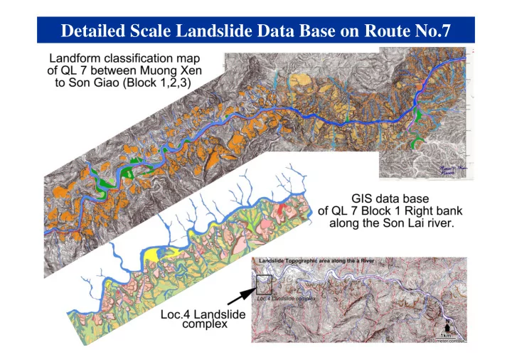
Detailed Scale Landslide Data Base on Route No.7 Main Outputs of WG3 Testing Group 1. A high-stress undrained dynamic-loading ring shear apparatus (ICL-2) was developed and applied to Vietnam (Simulating deep-seated landslides with 100- 200 m


slide-1
SLIDE 1

Detailed Scale Landslide Data Base on Route No.7

slide-2
SLIDE 2

Main Outputs of WG3 Testing Group

  • 1. A high-stress undrained dynamic-loading ring shear

apparatus (ICL-2) was developed and applied to Vietnam (Simulating deep-seated landslides with 100- 200 m in depth).

  • 2. The initiation mechanism and the dynamics of post-

failure motion of the targeted landslides was well studied.

  • 3. Hazard assessment technology of the precursor

stage of landslides was developed.

slide-3
SLIDE 3

The latest version, ICL‐2

High‐stress ring shear apparatus for large‐scale landslides. Maximum normal stress and undrained capacity is 3 MPa. A: Photo of the main apparatus. B: Mechanical structure C: Close up view of the shear box and sealing. D: Servo‐control system for Normal stress, shear stress, pore pressure and gap. Red arrow: control signal Black arrow: feed‐back signal Blue line is for water control

The design and construction of RSA (ICL-2)

slide-4
SLIDE 4

Simulating the Hai Van station landslide by LS-Rapid

Ring shear apparatus (ICL2)

slide-5
SLIDE 5

The Unzen-Mayuyama landslide-tsunami disaster in Japan. 15,000 people were killed by the landslide and its landslide-induced tsunami around Ariake Sea in 1792

Modeling of landslide-triggered tsunami for the 1792 Unzen Mayuyama case

slide-6
SLIDE 6

Photo courtesy by PASCO, Co., Ltd. Airphoto interpretation by GSI Landslide simulation by LS-RAPID

Risk assessment for the 2014.8 Hiroshima landslide disaster

LS-RAPID simulation (Sassa et al., 2014)

slide-7
SLIDE 7

Main Outputs of WG4 Mornitoring Group

  • 1. The web-based landslide monitoring system is

developed for the Hai Van station landslide.

  • 2. Equipments for landslide monitoring and early

warning were installed at the Hai Van station landslide

  • 3. A landslide flume model was developed and

applied to the case study

slide-8
SLIDE 8

Monitoring and early warning system

23

slide-9
SLIDE 9

Slope displacement in long-span extensometer

Oct Dec

Cumulative displace from upper position

Displacement start different position

slide-10
SLIDE 10

Displacement from GNSS since December 2015

After rainy season, almost stable Baseline analyses

slide-11
SLIDE 11

Groundwater table (Groundwater pressure gauge)

GL-30m GL-51m Rainfall gauge Granite rock Weathered granite 30m (0-30m screened) 51m(60m hole) (47.4-51.4m screened) Groundwater table

slide-12
SLIDE 12

Underground displacement (Borehole extensionmeter)

Outer tube extensionmeter Vex 30m Vex 80m

After scale out of inclinometer by landslide, Vex data will become important

slide-13
SLIDE 13

“Map and Web observation”

slide-14
SLIDE 14

29

Landslide experiment started in ITST from November 2015 Crane system Spraying system Image monitoring system

Landslide flume

slide-15
SLIDE 15

A PhD Research at Kyoto University