Contributions of Landscape Architecture toward Sustainable Water - - PowerPoint PPT Presentation

contributions of landscape architecture toward
SMART_READER_LITE
LIVE PREVIEW

Contributions of Landscape Architecture toward Sustainable Water - - PowerPoint PPT Presentation

Master of Landscape Architecture Program (MLA) Contributions of Landscape Architecture toward Sustainable Water Management in the Island of Gozo, Malta Damian Perez Beverinotti Xlendi Valley Gozo, Malta Ecological Landscape Modelling and


slide-1
SLIDE 1

Contributions of Landscape Architecture toward Sustainable Water Management in the Island of Gozo, Malta

Supported by the Programme Alßan, the European Union Programme of High Level Scholarships for Latin America, scholarship No. E07M403338AR

Damian Perez Beverinotti

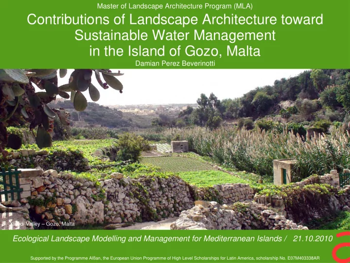
Xlendi Valley – Gozo, Malta

Master of Landscape Architecture Program (MLA)

Ecological Landscape Modelling and Management for Mediterranean Islands / 21.10.2010

slide-2
SLIDE 2

Presentation outline

  • Brief introduction to Mediterranean and Maltese landscape
  • Some issues affecting Gozitan landscape
  • Research questions / Scope and limitations
  • Research and planning methodology
  • Results / Findings
  • Conclusions
slide-3
SLIDE 3

Mediterranean Landscape

slide-4
SLIDE 4

4 / 43

Gozo Cultural Landscape

Gozo

  • Geomorphologic characteristics
  • Agricultural practices
  • Strategies to address water and soil conservation
slide-5
SLIDE 5

5 / 43

.

Gozo Cultural Landscape

Terraces

slide-6
SLIDE 6

6 / 43

.

Gozo Cultural Landscape

Source: Jones & Hunt (1994)

Terraces

slide-7
SLIDE 7

7 / 43

.

Gozo Cultural Landscape

Dams

slide-8
SLIDE 8

8 / 43

Gozo Cultural Landscape

Channels

slide-9
SLIDE 9

9 / 43

Gozo Cultural Landscape

Cisterns

slide-10
SLIDE 10

10 / 43

.

Gozo Cultural Landscape

Water mills Water mills

slide-11
SLIDE 11

11 / 43

.

Gozo Cultural Landscape

Water mills Dams Agricultural stores

slide-12
SLIDE 12

12 / 43

.

Gozo Cultural Landscape

Cane reed boundaries Opuntia sp. boundaries

slide-13
SLIDE 13

13 / 43

.

Gozo Cultural Landscape

Stone boundaries

slide-14
SLIDE 14

14 / 43

Challenges Rapid population Growth Development

1966 2004

Source: MEPA, Malta

slide-15
SLIDE 15

15 / 43

Water scarcity Climate change +

additional uncertainties to the planning process

Diminishing water resources Challenges

Jan Jul Dec

Rainfall distribution

slide-16
SLIDE 16

16 / 43

Challenges Agriculture less important as economic activity

Source: MEPA, Malta (2004)

Abandoned and fallow rural areas

  • Water scarcity
  • High labor costs
  • Cost of land
  • Fields size
slide-17
SLIDE 17

17 / 43

Research Questions

How can landscape architecture contribute through planning to cope with water scarcity in the Maltese cultural landscape How design may be guided in order to help in the sustainable management of water resources In which way may landscape architecture help allocate the scarce resources to solve the water management problems

slide-18
SLIDE 18

18 / 43

Scope and Limitations

While acknowledging the wider context of Gozo island, this research confines itself mainly to Xlendi basin The most up to date georeferenced data provided by Malta Environment and Planning Authority (MEPA) dated from 2003 and 2004 reflecting the rural and urban conditions of Gozo before the ascension of Malta to the EU. Mathematical modelling requires reliable data, scientific capacity and it is expensive. In this sense, ready available data from different sources on soil types, rainfall intensity, evapotranpiration have been used. Numerical models and results have been considered estimates and have been used as such. Conclusions consider the quality of the data available The unavailability of finances to carry out each aspect of the study to its logical conclusion has limited it. Nevertheless, these limitations do not significantly affect the quality of this study and are taken care of in the design of the study. Availability of ready data on related studies was also helpful.

slide-19
SLIDE 19

Methodology

slide-20
SLIDE 20

20 / 43

Landscape Planning and Water Management

Mathematical modelling

Quantitative approach

Non numerical approach

  • Requires reliable data
  • Requires Scientific capacity
  • Expensive
  • Cultural aspects?
slide-21
SLIDE 21

21 / 43

Source: Ecological Landscape Design and Planning / The Mediterranean Context (Makhzoumi & Pungetti 1999)

Ecological Landscape Design Paradigm

slide-22
SLIDE 22

22 / 43

Schematic illustration of the Ecological Landscape Association methodology.

Source: Ecological Landscape Design and Planning / The Mediterranean Context (Makhzoumi & Pungetti 1999)

Ecological Landscape Associations

slide-23
SLIDE 23

23 / 43

Water related processes

Runoff Erosion Leaching Percolation Mobilization of nutrients in the soil Mobilization of contaminants Evapotranspiration Evaporation Dilution

slide-24
SLIDE 24

24 / 43

Processes integration in both temporal and spatial scales

Ecological Landscape Associations Main water related process

Methodological approach

Watershed as spatial scale

Management units emphasizing the relationship between water and landscape

slide-25
SLIDE 25

Case Study – Xlendi basin

slide-26
SLIDE 26

26 / 43

Xlendi basin

Watershed Xlendi Victoria

600 Ha

65% rural 25% urban Second largest tourist related coastal settlement Land-use:

slide-27
SLIDE 27

27 / 43

Xlendi basin

High Landscape Sensitivity

Central valley is considered to be a high sensitivity landscape

Source: MEPA, Malta (2004)

slide-28
SLIDE 28

28 / 43

Xlendi basin

17% of the basin‘s fields are fallow or abandoned

Most located in the high slope areas of the valley

Source: MEPA, Malta (2004)

slide-29
SLIDE 29

29 / 43

Xlendi basin

18% of the basin is either irrigated or semi-irrigated Irrigated fields are clustered.

Source: MEPA, Malta (2004)

slide-30
SLIDE 30

30 / 43

Xlendi Flooding Risk

Source: Gozo & Comino Local Plan – MEPA 2006 and

Runoff water Accumulation during storms Obstructed discharge point

slide-31
SLIDE 31

31 / 43

Xlendi Flooding Risk

slide-32
SLIDE 32

Planning / Design Units for Xlendi basin

slide-33
SLIDE 33

33 / 43

Landscape Planning / Design Units

Slope Geology Drainage network Land use

slide-34
SLIDE 34

34 / 43

Landscape Planning / Design Units

  • Biotic
  • Abiotic
  • Cultural
  • Processes

related with water flow

slide-35
SLIDE 35

35 / 43

Upper urban areas / impervious soils / exotic species / runoff

  • Architectural heritage
  • Exotic and ruderal

vegetation

  • Sealed soils →

increased runoff (volume, frequency and flow duration)

  • Stormwater flowing to

sewers or down slope through the streets

Unit 1

slide-36
SLIDE 36

36 / 43

Upper urban areas / impervious soils / exotic species / runoff

Unit 1

  • Stormwater pollution

and excess runoff may be controlled by best management practices in streets and open spaces

  • Actions to collect

intercepted rain water in roofs might help reduce runoff

  • Traditional materials

might be combined with exotic plant species to build water related structures

slide-37
SLIDE 37

37 / 43

  • Extensively terraced

agricultural area

  • Runoff and

groundwater extraction are used as sources of irrigation water

  • Erosion occurs where

dry-stone walls have fallen into disrepair

  • Conservation of

terrace cultivation should be a priority

Walled terraces / Coralline Limestone – Globigerina / crops / runoff – erosion

Unit 2

slide-38
SLIDE 38

38 / 43

Walled terraces / Coralline Limestone – Globigerina / crops / runoff – erosion

Unit 2

  • Conservation of

terrace cultivation should be a priority

  • Small-scale high

value agricultural activities such us viticulture may be a solution for this problem

  • Water harvesting and

conservation techniques at field level may help reduce runoff while helping water scarcity

slide-39
SLIDE 39

39 / 43

Walled terraces / Globigerina - Coralline / garrigue / erosion - runoff

Unit 3

  • High proportion of

abandoned terraced fields

  • Conservation of

terrace cultivation should be a priority

  • High risk of erosion

associated with high slope

  • Natural vegetation

garrigue

  • Crops in the terraces
slide-40
SLIDE 40

40 / 43

Walled terraces / Globigerina - Coralline / garrigue / erosion - runoff

Unit 3

  • Conservation of the

rock walls and upper terraced fields should be a priority

  • Development

projects located in this unit should not impact the natural vegetation or increase erosion

slide-41
SLIDE 41

41 / 43

Walled terraces / blue clay / crops / erosion - runoff

Unit 4

  • High proportion of

abandoned terraced fields

  • High risk of erosion

associated with nature of soils - swelling clays

  • Crops
slide-42
SLIDE 42

42 / 43

Walled terraces / blue clay / crops / erosion - runoff

Unit 4

  • Irrigation water

availability in this area may help preserve the terraced fields

  • Cane and Opuntia
  • sp. boundaries may

be used to reduce erosion risk

  • Potential for water

harvesting

slide-43
SLIDE 43

43 / 43

Stream valley / lower coralline Limestone – valley fill / ‘widien’ vegetation / runoff - sedimentation

Unit 5

  • Provide unique

habitat for endangered species

  • Stream valley as a

corridor, linking patches and allowing for the movement of species

  • Farmed where slope

allows

  • Silted dams
slide-44
SLIDE 44

44 / 43

Stream valley / lower coralline limestone – valley fill / ‘widien’ vegetation / runoff - sedimentation

Unit 5

  • Techniques of runoff

water harvesting might be applied in the upper parts of the unit

  • Sedimentation and

the ecological functions of the stream should be taken into consideration

slide-45
SLIDE 45

45 / 43

Lower urban area / valley fill / sedimentation - runoff

Unit 6

  • Sedimentation and

runoff main water processes

  • Receive water,

pollution and rubbish from upslope

  • Tourist quality of the

area

slide-46
SLIDE 46

46 / 43

Lower urban area / valley fill / sedimentation

Unit 6

  • Actions to preserve

sedimentation up- stream but avoid it in the storm-water sewers should be taken

  • Development should

not occur where runoff water coming from upslope might be reduced

  • Low urban area

should adapt to live with water

slide-47
SLIDE 47

47 / 43

Conclusions

The methodology used in this study might help address the particularities of each zone of a basin in a way that scientific, cultural and ecological understanding of the landscape and the water related processes dominates the process of design/planning. The case study assists in the understanding of the link between landscape components and water driven processes in Xlendi basin which in turn might help as a base for sustainable planning decisions.

slide-48
SLIDE 48

Makhzoumi, J. & Pungetti, G., 1999. Ecological landscape design and planning: The Mediterranean Context, London: E& FN Spon. Malta Environment and Planning Authority (MEPA). Landscape Assessment Study for the Maltese

  • Islands. Floriana, Malta. 2004.

Van Grunderbeeck P. & Tourre Y. M.; Mediterranean Basin: Climate Change and Impacts during the 21st Century, in Climate Change and Energy in the Mediterranean. Plan Blue,UNEP. 2008. 558p . Jones, A. & Hunt, C., 1994. Walls, wells and water supply: aspects of the cultural landscape of Gozo, Maltese Islands. Landscape Issues, 11, 24-29.

References

in this presentation

Thank you for your attention

Contributions of Landscape Architecture toward Sustainable Water Management in the Island of Gozo, Malta

Ecological Landscape Modelling and Management for Mediterranean Islands / 21.10.2010