completing the map
play

Completing the Map with Street-level Imagery Christopher Beddow - PowerPoint PPT Presentation

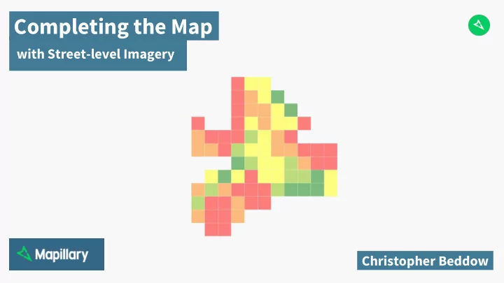
Completing the Map with Street-level Imagery Christopher Beddow #CompletetheMap What is it? Web application for image capture tracking Grid-based tracking of task or challenge Leaderboard for community coordination, recognition, and


  1. Completing the Map with Street-level Imagery Christopher Beddow

  2. #CompletetheMap What is it? ‣ Web application for image capture tracking ‣ Grid-based tracking of task or challenge ‣ Leaderboard for community coordination, recognition, and competition ‣ Measurement of progress based on OSM road distances Why? ‣ Targeted image collection ‣ Dashboard for community leaders

  3. #CompletetheMap Phase I: Uganda ‣ April ���� ‣ Over ���k images from YouthMappers ‣ University chapters organised Mapillary photo walks ‣ Leaderboard showed user progress

  4. #CompletetheMap Phase II: Ottawa ‣ August ���� ‣ Over ���k images from Bike Ottawa ‣ Open source app, zzptichka heavily contributed �Yaro Shkvorets� ‣ First grid-based system, metro area ‣ Unified leaderboard and map ‣ Resulting data used for OSM and bike stress map

  5. Revamp Challenges Solutions ‣ A better way to fetch and display ‣ Leaderboard API �open� contributor stats ‣ A better way to visualize progress ‣ Simple grids, � quantiles ‣ A better way to see temporal ‣ Mapbox JS GL - filtering vector tiles by date, uniqueness change ‣ Distance APIs -- unique and redundant �open� ‣ A better way to measure completion ‣ Run API calls hourly from preset GeoJSON shape ‣ Reduce server load ‣ Grid generator tool and modifiable settings script ‣ A DIY method to create a challenge

  6. #CompletetheMap Phase III: Brasilia ‣ November ���� ‣ Simplified layout ‣ More precise progress measurement ‣ Local users helped spread the word ‣ Over ��k images from OSM community ‣ ���km of OSM ways mapped

  7. #CompletetheMap Mobile version ‣ Web address redirects on mobile ‣ Compact layout ‣ Location icon ‣ Useful for mapping on the go ‣ Best with an external camera

  8. Do it yourself Creating a grid https://mapillary.github.io/mapillary_greenhouse/grid-generator/ ‣ Draw rectangle, upload geojson, or choose center point ‣ Indicate network type, cell units ‣ Indicate cell size, and number of columns ‣ OSM Overpass API - road distances ‣ Variation of Geoff Boeing’s OSMNX ‣ Geoprocessing with Turf.js

  9. Do it yourself Creating a task ‣ Choose a city size area or smaller ‣ Add grid.geojson to directory ‣ Choose start and end date ‣ Edit settings.js to add details ‣ Submit to Mapillary for server-side hourly processing

  10. Verify the results Teaching the computer ‣ Users can help improve algorithms ‣ Validating detections as accurate ‣ Traffic signs that are validated can be precisely positioned with computer vision ‣ Thousands of verifications ensure world class data quality ‣ Traffic signs detected in > � photo are added to traffic sign tiles in OSM iD

  11. Back to the map Using images in OSM ‣ OSM iD: resize viewer new ‣ JOSM: ��� degree image support new ‣ Traffic sign overlay - precise positions due to computer vision ‣ ��� million photos worldwide ‣ More new features on the way

  12. Enhanced Editing Placement Tools http://mapillary.github.io/mapillary-js/ ‣ Click in image to add map points ‣ Planned for OSM iD ‣ Available now in open-source library: Mapillary-JS

  13. Highlights ���8 Global Challenge ‣ � - �� May, ���� ‣ Ballerup, Denmark - ��k images/���km ‣ Kyiv, Ukraine - ��k images/���km ‣ Washington, DC, USA - ��k images/��km ‣ Funchal, Madeira - ��k images/��km ‣ Heredia, Costa Rica - ��k images/��km ‣ San Donato Milanese, Italy - ��k images/��km ‣ Myanmar, Hungary, Spain, Scotland, Canada, Lithuania, and more

  14. Map your world Next Global Challenge ‣ � - �� August, ���� ‣ Tweet to @mapillary using hashtag #CompletetheMap to nominate your city ‣ Current participants include Norway, Sweden, Brunei, Costa Rica, Colombia, Uzbekistan, Australia, Denmark, Russia, Germany, Belarus, Falkland Islands/Malvinas, Spain, USA ‣ Top � mappers receive a GoPro Hero � Black ‣ No setup required, we’ll make a dashboard

  15. The Future Building better maps ‣ Better measurement of OSM edits from images ‣ Better OSM editing tools for street-level imagery ‣ Better data extraction using computer vision and structure from motion ‣ Better access to machine learning data layers

  16. Questions? @c_beddow / christopher@mapillary.com

Download Presentation
Download Policy: The content available on the website is offered to you 'AS IS' for your personal information and use only. It cannot be commercialized, licensed, or distributed on other websites without prior consent from the author. To download a presentation, simply click this link. If you encounter any difficulties during the download process, it's possible that the publisher has removed the file from their server.

Recommend


More recommend