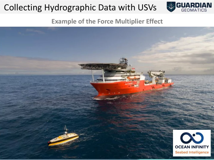
SLIDE 1 1
Example of the Force Multiplier Effect
Collecting Hydrographic Data with USVs
SLIDE 2 Contents
- Scope of Work and Outcomes
- MASS Operations
- Lessons Learned
SLIDE 3 Original Scope of Work
The survey scope of work undertaken from the vessel includes the following;
▪ Mobilisation of the Seabed Constructor’s over the side pole ▪ Mobilisation of three MASS units ▪ Sea acceptance trails for Seabed Constructor and three MASS units ▪ Deployment of four bottom mounted tide gauges ▪ Bathymetric survey of area to IHO S-44 requirements I. Order 1a for water depths greater than 10m II. 100% acoustic coverage shall be achieved for the entire are of operations – full seafloor search ▪ Contour delineation out to the 40m contour ▪ Box-in surveys for features identified by the Client ▪ Recovery of four bottom mounted tide gauges ▪ Demobilisation ▪ Final Reporting & Processing
SLIDE 4
Work area overview – 800km2
SLIDE 5 Scope of Work – Outcomes
▪ Successfully mobilised three MASS units ▪ Passed the Sea acceptance trails for Seabed three MASS units ▪ Successfully deployed four bottom mounted tide gauges ▪ 61.8 % completion (to date) of the Bathymetric survey
- I. Order 1a
- II. 100% acoustic coverage
▪ Contour delineation out to the 45m contour ▪ 12 x Box-in surveys - Completed ▪ Recovered two bottom mounted tide gauges ▪ Identified 13 unknown wrecks ▪ Identified 94 additional features (below impact threshold) ▪ Completed 7460 line km in 20 days (to 1 July) ▪ 373 km per day avg. (best day 630 km) ▪ Phase 2 - has just completed
SLIDE 6
Area Coverage DTM
SLIDE 7
3D View
SLIDE 8 Unchartered Wreck 1
Minimum Depth 36.43m Mean Seabed Depth 43.30m Length 59.57m Width 15.26m Height 9.08m
SLIDE 9 UNCHARTERED WRECK 2
Minimum Depth 16.30m Mean Seabed Depth 23.00m Length 48.00m Width 11.60m Height 7.30m
SLIDE 10
30th June 2019 - Nouadhibou Port
SLIDE 11
1st July 2019 - Nouadhibou Port
SLIDE 12 12
Fishing!
SURROUNDED!
SLIDE 13 Summary of the MASS Operations
3 x MASS Units:
- ASV 3, 4 and 8 successfully mobilised with a new payload.
- 7.7m vessel built by ASV Global – draft .99m
- Twin Yanmar motors, 1,000 L onboard
- AIS, 3 Cameras,
- Moonpool for payload equipment
SLIDE 14
TOTAL LINEAR KILOMETRES
SLIDE 15
Line KM per Day per Platorm
SLIDE 16
Vessel & MASS Operational Timeframes
SLIDE 17 17
Overarching document was the UK Code of Practice. Captain had overall responsibility. We operated MASS units on the basis of ‘ships equipment’ We had 10 experienced
competent.
- No RYA license
- No ASV Certificate
Once suitable trust obtained
- we could allow operators to
work under supervision of a competent operator
SLIDE 18 18
Control of Operations
SLIDE 19
Launch and Recovery (LARS)
SLIDE 20
Launch and Recovery (LARS)
SLIDE 21 Major Lessons Learnt
MASS Unit Survey Operations More effort required around treating them as autonomous units v unmanned survey vessels. Need to reduce human intervention in survey activity. MASS Unit Operations Took some time to get operational at efficient levels. Major issues being:
- Trust in the systems
- Trust in the people / operators
- Setting suitable data acquisition methodology
Data Transfer Accessing Data onboard is important to determine acceptable coverage. We have implemented an independent wi-fi system for data downloads instead of unit recovery.
SLIDE 22 USV’s a Force Multiplier
Unmanned Survey Vessel’s:-
- Dramatically increase the rate of effort achieved per day
- Significant reduction in fuel usage
- Minimal increase in headcount
- Reduce the risk of shallow water work.
However:-
- Require some different approaches to single vessel acquisition
- Gains diminish with increasing units
SLIDE 23 23
Final Data Coverage
SLIDE 24
Thank You