Bathy-500 Bathy-500 TM Bathy-500 Bathy-500 TM TM TM Hydrographic - - PowerPoint PPT Presentation

bathy 500
SMART_READER_LITE
LIVE PREVIEW

Bathy-500 Bathy-500 TM Bathy-500 Bathy-500 TM TM TM Hydrographic - - PowerPoint PPT Presentation

Bathy-500 Bathy-500 TM Bathy-500 Bathy-500 TM TM TM Hydrographic Survey Echosounders Hydrographic Survey Echosounders Hydrographic Survey Echosounders Hydrographic Survey Echosounders Bathy 500DF Dual Frequency Bathy 500DF Dual Frequency


slide-1
SLIDE 1

Bathy 500DF Dual Frequency Bathy 500MF Multi Frequency Bathy 500MF Multi Frequency Bathy 500DF Dual Frequency

Bathy-500 Bathy-500 TM

TM

Hydrographic Survey Echosounders Hydrographic Survey Echosounders

Bathy-500 Bathy-500 TM

TM

Hydrographic Survey Echosounders Hydrographic Survey Echosounders

slide-2
SLIDE 2

The Bathy-500 Series of echo sounders was specifically designed to provide the hydrographic surveyor with the best thermal chart based scientific echo sounder in the world. The echo sounder is available in single and dual frequency options and is portable and rugged. It has many features which are specifically designed for ease of use and reliability. SyQwest Inc has sold over 3,000 Bathy-500 Series echo sounders world wide in the last 10 years. The Bathy-500 Series of echo sounders was specifically designed to provide the hydrographic surveyor with the best thermal chart based scientific echo sounder in the world. The echo sounder is available in single and dual frequency options and is portable and rugged. It has many features which are specifically designed for ease of use and reliability. SyQwest Inc has sold over 3,000 Bathy-500 Series echo sounders world wide in the last 10 years.

Bathy-500 Series Background Information

slide-3
SLIDE 3

Bathy-500 Applications

Lake and River Hydrographic Surveys Inshore and Coastal Hydrographic Surveys Pre and Post Dredging Assessment Surveys

slide-4
SLIDE 4

Bathy-500 Features

Ruggedized Design Portable Water Resistant Design User Selectable Frequency Control High Resolution Thermal Printer Dual Frequency Upgradeable (Optional) internal DGPS Compatible with Hypack ™ and HYDROPro ™ Software Processing Packages Depth Resolution 1cm Ruggedized Design Portable Water Resistant Design User Selectable Frequency Control High Resolution Thermal Printer Dual Frequency Upgradeable (Optional) internal DGPS Compatible with Hypack ™ and HYDROPro ™ Software Processing Packages Depth Resolution 1cm

slide-5
SLIDE 5

Keypad and LCD Display Rugged and Simple to use Large Numeric Depth Display Keypad and LCD Display Rugged and Simple to use Large Numeric Depth Display

Bathy-500 User Interface

slide-6
SLIDE 6

Heave Compensator input Faster printing speeds 1X thru 7X up to 21.5 cm per minute Merge and Split operational print modes Independent Draft offset for HF and LF Centimeter resolution for Draft offset User selectable grid lines Heave Compensator input Faster printing speeds 1X thru 7X up to 21.5 cm per minute Merge and Split operational print modes Independent Draft offset for HF and LF Centimeter resolution for Draft offset User selectable grid lines

Bathy-500 New Features

slide-7
SLIDE 7

Merged Mode: High and low frequency are printed together utilizing the full chart display. With the higher frequency printed above the lower frequency. Merged Mode: High and low frequency are printed together utilizing the full chart display. With the higher frequency printed above the lower frequency. Split Mode: The chart is divided in half with each frequency independently printed. The higher frequency is printed on the upper half of the chart, the lower frequency on the bottom half. Split Mode: The chart is divided in half with each frequency independently printed. The higher frequency is printed on the upper half of the chart, the lower frequency on the bottom half.

Split & Merged Operational Print Modes

slide-8
SLIDE 8

Optional items available for the Bathy-500

Transducer over the side pole mount Internal Trimble DMS Series DGPS EDI Echo Sounder Test Set Heave Compensator Transducer over the side pole mount Internal Trimble DMS Series DGPS EDI Echo Sounder Test Set Heave Compensator

slide-9
SLIDE 9

Bathy-500 Advantages versus the Competition

Price versus Performance Less cost for comparable function Dual Frequency Upgradeable Internal DGPS Upgradeable Low meantime between failures Exceptional Customer Support Price versus Performance Less cost for comparable function Dual Frequency Upgradeable Internal DGPS Upgradeable Low meantime between failures Exceptional Customer Support

slide-10
SLIDE 10

Bathy-500 Series 33Khz Data

  • Lake Ramsey Louisiana
  • Bottom Type: Hard Clay (with 2‐6 silt overlay)
slide-11
SLIDE 11

Bathy-500 Series 200Khz Data

  • Lake Ramsey Louisiana
  • Bottom Type: Hard Clay (with 2‐6 silt overlay)
slide-12
SLIDE 12

Bathy-500 Series 200Khz Data

  • Woods Hole Massachusetts
slide-13
SLIDE 13

Bathy-500DF 33/210Khz

  • Providence Harbor, silt over sand
slide-14
SLIDE 14

SPECIFICATIONS

  • Depth Ranges:

Units of 0‐15, 0‐30, 0‐60, 0‐120, 0‐240, 0‐480, 0‐960, 0‐1920 Feet or 0‐5, 0‐10, 0‐20, 0‐40, 0‐80, 0‐160, 0‐320, 0‐640 Meters

  • Phasing:

0‐120, 60‐180, 120‐240, 180‐300,etc.. (displays 120ft range at 60 ft increments up to 1800‐1920) Feet, Auto or 0‐40, 20‐60, 40‐80, 60‐100, 80‐120,etc..(displays 40m range at 20m increments up to 600‐ 640) Meters, Auto

  • Chart Record:

8.5 inch X 90 Feet (21.59cm x 27.43mt) High‐Contrast Thermal Paper

  • Digital Display:

LCD (4 lines X 16 characters) 0.25 inch (6.35mm) characters (Depth Display 0.75 inch (19.05mm) characters) (Backlighting: Electro‐luminescent)

  • Resolution:

0.01 units for depths less than 100 meters; 0.1 for depths greater than 100 meters; 0.1 feet on all ranges

  • Accuracy:

Meets or exceeds all current IHO hydrographic requirements for single beam echo sounders 0‐40m 2.5cm, 40‐200m 5.0cm, >200m 10.0cm

  • Depth alarms:

Shallow & Deep (selected by keypad)

  • Speed of Sound:

4600 ‐ 5250 feet/second (1393 ‐ 1590 meters/second) (user selected via keypad)

  • Offset:

0 to +30 feet or 0 to +10 meters (allows the user, via keypad, to adjust for net sum of transducer depth and tide)

  • Geographic Pos.: NMEA‐0183 Format GGA or GLL Format from GPS/DGPS
  • Data I/O:

COM 1 provides bi‐directional interface to PC or other peripheral device; This port accepts external annotation from external sources such as hydrographic software. COM 2 accepts GPS/DGPS inputs and provides additional (from COM1) data outputs.

  • Data Output:

A) NMEA‐0183 Format (GGA or GLL) B) RS‐232/422 Data Output to the following formats: ODEC PMC dt (true depth & status) ‐ ODEC dpt (proprietary format; time & position [when available], true depth)‐ Atlas DESO 25 ‐ ODOM Digitrace ‐ ODOM Echotrac ‐ NMEA dbt ‐ NMEA dbs

  • Heave Compensation: Compatible with Teledyne TSS Format (Bathy‐500DF)
  • Acoustic Output:

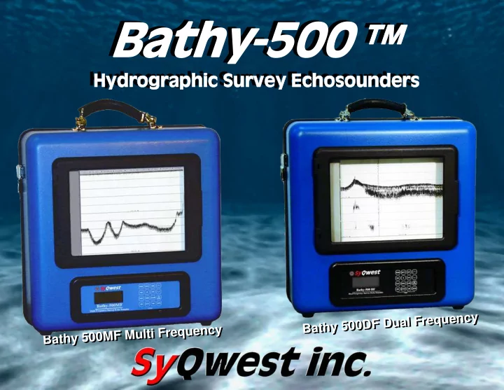
Bathy‐500DF; Single and Dual (interleaved) frequencies (user selectable & changeable via keypad) from these: 33kHz,40kHz,50kHz, 210kHz, 33/210Khz, 50/210kHz (@600watts maximum) Bathy‐500MF; Single frequency ( user selectable & changeable via keypad) from these: 33Khz,40Khz, 50Khz,210Khz (Acoustic output=600watts)

  • Input Power:

11‐30 volts D.C. (1.5 amps @ 12 v. 0.5 amp @ 30 v.) or 115/230 volts A.C. 50/60 hertz (20 watts)

  • Dimensions:

Height (including handle) 19 inches (48.26cm) Width 17.5 inches (44.45 cm) Depth 10 inches (25.4 cm) Weight: 36 lbs.(15.87 kg) (plus transducer)

End of presentation