
SLIDE 1
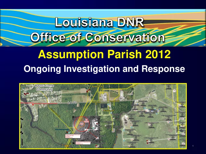
Assumption Parish 2012
Ongoing Investigation and Response
1
Assumption Parish 2012 Ongoing Investigation and Response 1 Bayou - - PowerPoint PPT Presentation
Assumption Parish 2012 Ongoing Investigation and Response 1 Bayou Corne/Napoleonville Salt Dome Slurry Area Area of potential instability Known area of instability 2 2 Sinkhole Immediate Response/Orders Received report of
1
2 2
3 3
4
Texas Brine to drill investigatory well to the abandoned cavern
approved on Aug. 13 deadline
with need for investigatory well
to report daily activities and monitoring efforts
effort to evaluate potential hydrocarbon/saltwater impact on aquifer
4
5
assistance retroactive to date
potential penalties for failure to comply with assistance order
5
6
7
7
8
9
10
10
11
State and Local Government Participants
Christopher Knotts, PE DNR Kevin Davis GOHSEP Madhurendu Kumar, PhD, PG DNR Pat Santos GOHSEP Commissioner Jim Welsh DNR Chris Guilbeaux GOHSEP Gary Ross, PE DNR James Smith GOHSEP Joe Ball DNR Clay Trachtman DHH Chris Sandoz, PE DNR Johan Forsman DHH Thomas Van Biersel, PhD DNR Jake Causey DHH Donald Haydel DNR John Johnston III LGS Laurence Bland DNR Chacko John, PhD LGS Gary Snellgrove DNR Warren Schulingcamp LGS David Elfert DNR Brian Harder LGS Kevin Masden DNR Riley Milner LGS Secretary Peggy Hatch DEQ Julius Langlinais, PhD LSU (Ret.) Chris Piehler DEQ Louis Thibodeaux, PhD LSU Celeste Bonnecaze DEQ Donald Goddard, PhD LSU Dutch Donlon DEQ Allan Pulsipher, PhD LSU Larry Gill DOTD Richard Hughes, PhD LSU Jeff Nunn, PhD LSU
11
12
Federal Government and Industry Advisors
Stephen Spencer USDOI Mark Cartwright Texas Brine R Williams USGS Kenneth Blanchard Texas Brine Mark Meremonte USGS Joel Warneke Texas Brine Elizabeth Lemersal USGS Greg Ball Chevron Jon Kolak USGS Laura Swafford Chevron Stephen Hammon USGS Cung Vu Chevron Max Ethridge USGS Bob Langan, PhD Chevron Michael Blanpied USGS Michael LeBlanc CrossTex Energy Harley Benz USGS Bobby McDonald Florida Gas Pipeline J Rubenstein USGS Bob Thoms, PhD Texas Brine consultant William Leith USGS Joe Ratigan, PhD Consultant to Oxy Steve Hickman USGS Bill Goodman Respec William Ellsworth USGS Ted Bourgoyne. PhD BEI John Lovelace USGS Boyce Clark, PhD Arcadis George Arcement, Jr. USGS Rebecca Fuller USCG Dayton Pannell USCG Steven Horton, PhD University of Memphis David Borns Sandia National Laboratories Stephen Bauer Sandia National Laboratories
12
13
13
14
Current theories for possible causes for slurry hole / bubbling
14
15
16
16
17 17
18
18
19 19
Most recent integrity test – July 2010
20
Crosstex No. 2
20
21
Crosstex No. 1
21
Existing ground water wells evaluated – sampling does not indicate presence of hydrocarbon or increased salinity in alluvial aquifer at these locations
22
Observation well action plan for the Mississippi River Alluvial Aquifer developed as extra measure to ensure public safety
Site identified and driller under contract to drill initial
landowner
in the investigation
aquifer
23
Site selected based on several factors
best location to ensure public safety
more likely to be in shallowest spots and linger longest under heavy clay
24
25
renewed seismic activity
identify potential alternative causes of natural gas bubbling and subsidence
theory and analysis of information gathered and data required
26
sites for observation wells
public and local officials
equipped to detect natural gas and other releases
27
equipment
28
29
30 30