SLIDE 1
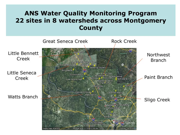
ANS Water Quality Monitoring Program 22 sites in 8 watersheds across Montgomery County
Little Bennett Creek Little Seneca Creek Watts Branch Great Seneca Creek Rock Creek Northwest Branch Paint Branch Sligo Creek
SLIDE 2
ANS monitoring site on the tributary of Ten Mile Creek near the ford on West Old Baltimore Road, April 2009
SLIDE 3
ANS monitoring site on the mainstem of Ten Mile Creek, 2010
SLIDE 4 Some of the stoneflies and mayflies we find at Ten Mile Creek
We find good diversity, great abundance, and sensitive
- rganisms at Ten Mile Creek
SLIDE 5 Stream dwellers also depend
- n healthy, well-functioning
forest ecosystems
SLIDE 6 The model uses Upper Rock Creek to estimate effects
Creek, but the watersheds are in different geological zones, have different soils, and very different topography
Ten Mile Creek Upper Rock Creek
SLIDE 7
ANS monitoring site at Muncaster Mill Road ANS monitoring site at Agricultural History Farm Park ANS monitoring site on the mainstem of Ten Mile Creek Upper Rock Creek Ten Mile Creek Steep slopes on Ten Mile Creek upstream
SLIDE 8 Tropical Storm Lee
cfs
- USGS stream gage
- vertopped
- 5'-high flood in Mease
pasture and Black Hill RP
Hurricane Camille”
fence and cattle guard washed away
Baltimore Road
monitoring sites washed
at both monitoring sites
SLIDE 9
Effect of Tropical Storm Lee on ANS Ten Mile Creek mainstem site (near LSTM 303B)
Flood debris on branches 5’ above stream bank Sediment of cobbles, gravel, and sand deposited on the right channel around the island, choking it off 5’ pole
SLIDE 10 Storm on October 12-13, 2011
smaller than a 1-year storm
- Rain started at 21:45
- n October 12
- 1.17” fell from 16:00-
16:55 on October 13
20:30 on October 13
SLIDE 11 Effect of October 12-13, 2011, storm on ANS Ten Mile Creek tributary site (LSTM 204)
- Banks washed out, undercut; sediment
deposited downstream
- Berm between stream and road washed out
- 30” deep pool in the ford – a Mercedes was
submerged in it for 3 hours
SLIDE 12 Storm on February 29, 2012
- 2” rain – less than a “1-year
storm”
- 4 stormwater ponds along
- Rt. 355 were overtopped
- USGS stream gage recorded
rise in discharge from 119 cfs to 2,180 cfs in 25 minutes
- 5'-flood in Mease pasture
and Black Hill Regional Park
- Damage to W. Old Balto Rd.
and foot trail in Black Hill Park
SLIDE 13
Floodwaters covered the bridge in Black Hill Regional Park The footpath had to be rebuilt
SLIDE 14 Storm on January 30-31, 2013 (greater than a 2- year storm)
- 5.08” of rain fell in 2 waves
- Peak discharge of 1,760 cfs
- Mainstem “went on a
rampage” at Norman Mease’s farm
- Massive amounts of sediment
deposited around the island in the mainstem
- The tributary did not rise at
all, but flooding from the mainstem washed out the banks of the tributary and widened it
- The road was damaged
- The tributary is now <2’ from
- W. Old Baltimore Road
SLIDE 15
Dead pickerel frog Deposition around island and in pool Tributary widened, now very close to road Effects of January 30-31, 2013 storm Right channel around the island is now filled with sediment Deposition around the island and in the pool
SLIDE 16
Development in Clarksburg, 2005-2011
Watershed mostly forested in 2005 Development of Stringtown Road and Snowden Farm Parkway began in 2006, followed by Woodcrest and Gateway Commons (2007-2010) and the widening of route 355 (fall 2012)