2
play

2 What Transport for Cambridge? Submission to Greater Cambridge - PDF document

1 2 What Transport for Cambridge? Submission to Greater Cambridge City Deal By Professor Marcial Echenique OBE ScD RIBA RTPI and Jonathan Barker Introduction Cambridge Futures was founded in 1997 as a joint initiative between the City and


  1. 1 2 What Transport for Cambridge? Submission to Greater Cambridge City Deal By Professor Marcial Echenique OBE ScD RIBA RTPI and Jonathan Barker Introduction Cambridge Futures was founded in 1997 as a joint initiative between the City and University to inform the debate about the future development of Cambridge. The first study tested several development options and its findings have greatly influenced the Plan for Cambridge which currently is being implemented 1 . Clearly the level of growth allowed by the plan will result in a corresponding increase in travel, putting an even greater strain on a transport infrastructure that is already at capacity in many areas and suffering from a deficit of investment. Cambridge Futures 2 : What transport for Cambridge? addressed this problem. Method of carrying out the transport study 
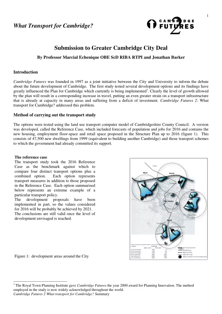
The options were tested using the land use transport computer model of Cambridgeshire County Council. A version was developed, called the Reference Case, which included forecasts of population and jobs for 2016 and contains the new housing, employment floor-space and retail space proposed in the Structure Plan up to 2016 (figure 1). This consists of 47,500 new dwellings from 1999 (equivalent to building another Cambridge) and those transport schemes to which the government had already committed its support. The reference case The transport study took the 2016 Reference Case as the benchmark against which to compare four distinct transport options plus a combined option. Each option represents transport measures in addition to those proposed in the Reference Case. Each option summarised below represents an extreme example of a particular transport policy. The development proposals have been implemented in part, so the values considered for 2016 will be probably be achieved by 2021. The conclusions are still valid once the level of development envisaged is reached. Figure 1: development areas around the City 1 The Royal Town Planning Institute gave Cambridge Futures the year 2000 award for Planning Innovation. The method employed in the study is now widely acknowledged throughout the world. Cambridge Futures 2 What transport for Cambridge? Summary

  2. 2 Cycling and walking – a major expansion of the 1. cycling network including and outer circular route, and better connections from Cambridge to surrounding villages. The study did show how other options considered below would affect cycling and walking. For example, road pricing would encourage people to cycle or walk rather than travel by car. Figure 2 Expansion of cycling and walking 2. Public transport – rapid transit routes segregated from traffic to avoid delays and with tunnels under the city centre, to the rail station and east Cambridge. Potentially 2 tunnels for public transport only were considered – one running East-West and another North-South allowing the bus rapid transit to reach a remodelled bus station and the main railway station without being impaired by congestion. Figure 3: Public transport option Public transport option – Entrance to the tunnel under the City centre Cambridge Futures 2 What transport for Cambridge? Summary

  3. 3 Highways – an orbital road around 3. Cambridge with link roads running parallel to the A14 and M11 to cater for local traffic, and tunnels under Shelford and the hills south of the city to reduce its environmental impact. The Structure Plan identifies the need for new road links south of Cambridge from the M11 to Addenbrookes which has been built, and north east of Cambridge from a new A14 interchange near Fen Ditton to Airport Way. Figure 4: Orbital highway option Figure 6: Orbital around the East and South of the City 4. Road pricing – to manage the demand for road space by imposing a charge on drivers during the busy morning and evening periods equivalent to £3.50 per day for crossing an outer cordon and £0.50p per day for driving within the cordon. Drivers would have free access to the park and ride sites and no charge off peak 10am to 4pm and 7pm to 7 am. Figure 5: Road pricing option The road pricing option tested a system based on similar technology to the London congestion charge scheme. This uses number plate recognition cameras to detect vehicles as they cross an outer cordon. There are also roving detector vehicles within the cordon area. For Cambridge, the cordon was assumed to encompass the whole of the urban area. Entrance to road pricing cordon Cambridge Futures 2 What transport for Cambridge? Summary

  4. 4 5. Combined option - the study also tested all of the above options in combination which gives the best results. The results for the combined proposals (see figure 6) was highly satisfactory as the reduction in congestion will produce time saving for transport users estimated at £28 million per year and generating £30 million per year of net revenues from the congestion charge helping to fund up to 50% the overall capital cost of the combined proposals estimated at £500 million. Figure 6 Combined option: extension of cycling and walking networks, high quality public transport, orbital road and congestion pricing. The Findings The committed transport schemes will not be sufficient to cater for the large increase in travel and many areas of the city will be gridlocked. The delays would jeopardise economic growth, worsening environmental conditions and the quality of life. Comparing conditions across the Sub region with those in 2001, there would be increases of around 40% in the cost of living, 30% in production costs for employers. There would be an increase of 30% in fuel consumption in and around the Cambridge urban area which corresponds to a 30% increase in transport related carbon dioxide emissions Public Transport: A fast and extensive local rapid transit system would not result in a significant improvement in traffic conditions. Tunnels would provide an opportunity for improving the conditions for pedestrians in bus and rail stations and in the central area as well as the level of service for public transport users. However, these benefits do not justify the high construction costs of tunnels unless a higher patronage is achieved by diverting car users to the public transport. Highway improvements: The orbital road would cater for some of the demand for traffic movements and provide a link between the major proposed developments around the north, north-west, south and east of Cambridge, such as Northern Fringe housing and existing Science Parks, North West development, Southern Fringe housing and Addenbrookes biomedical campus and future Airport site. This would be particularly advantageous around the south and east of Cambridge where there is currently a lack of capacity for orbital traffic movements. It would improve overall traffic conditions in Cambridge and for the Sub-region as a whole, but there would be a slight increase in the number of car trips and distance travelled which results in a forecast increase in carbon emissions compared to the Reference Case unless a reduction of car usage is achieved in the more congested areas. Road Pricing: This option would raise a lot of revenue, (around £40 million in the first year of operation, declining to around £30 million per year over the first 5 years as households and jobs relocate to avoid paying the congestion charge. This option would greatly reduce traffic levels in Cambridge and overall carbon emissions. The option tested could raise in financial markets up to £250 million of capital based on future revenues streams from the charge, depending on whether the agency responsible was public or private, and the length of time that revenue can be collected by the agency (hypothecation period), and whether there is an off-peak charge. Combined Option: The options work well together as a whole. Road pricing acts as an effective means of managing the demand for car travel in Cambridge and the rapid transit system gives people a fast and reliable alternative to the car. The orbital highway allows drivers to more easily access the park and ride service that best serves their Cambridge Futures 2 What transport for Cambridge? Summary

Download Presentation
Download Policy: The content available on the website is offered to you 'AS IS' for your personal information and use only. It cannot be commercialized, licensed, or distributed on other websites without prior consent from the author. To download a presentation, simply click this link. If you encounter any difficulties during the download process, it's possible that the publisher has removed the file from their server.

Recommend


More recommend