Wildland Fire Smoke & Roadway Visibility: Predict, Prepare and - - PowerPoint PPT Presentation

wildland fire smoke roadway visibility predict prepare
SMART_READER_LITE
LIVE PREVIEW

Wildland Fire Smoke & Roadway Visibility: Predict, Prepare and - - PowerPoint PPT Presentation

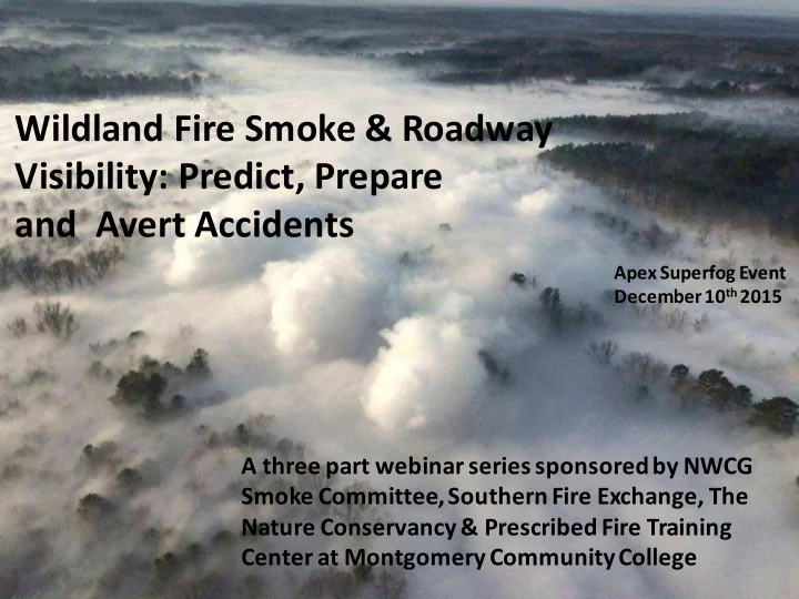
Wildland Fire Smoke & Roadway Visibility: Predict, Prepare and Avert Accidents Apex Superfog Event December 10 th 2015 A three part webinar series sponsored by NWCG Smoke Committee, Southern Fire Exchange, The Nature Conservancy &


slide-1
SLIDE 1

Wildland Fire Smoke & Roadway Visibility: Predict, Prepare and Avert Accidents

A three part webinar series sponsored by NWCG Smoke Committee, Southern Fire Exchange, The Nature Conservancy & Prescribed Fire Training Center at Montgomery Community College

Apex Superfog Event December 10th2015

slide-2
SLIDE 2

But first some webinar business: √ Start Recording √ Recognition of our partners √ Recognition of our presenters √ Archived by FRAMES √ Continuing Forestry Education Credits √ Webinar flow: time / presentation /questions

Southern Fire Exchange

slide-3
SLIDE 3

For those who wish to earn Continuing Forestry Education credits or to receive updates! I will need:

  • 1. Name: Last, First, & M.I.
  • 2. “email address” &
  • 3. “physical mailing address”

This is for CFE and MCC PFTC Certificates as well as for future mailings in relation to the webinars. This information can be entered into the webinar Chat Box or email it to: gary.curcio@gmail.com Also, I can be reached at 252-624-7635 (cell #)

slide-4
SLIDE 4

Part 2: “Weather information & Tools Available to Stay Ahead of Superfog Events or Severely Reduced Roadway Visibility”

“The tools for wildland smoke are building blocks of knowledge that deal with fuel, weather fire, and emissions”.

slide-5
SLIDE 5

“Charles K. McMahon… in his 1980-85 RPR commented;

through “Situational Awareness” Wildland fire managers, both prescribed & wildfire, can create opportunities to minimize the detrimental effects of fire’s smoke …..”  smoke from smoldering combustion  understanding moisture relationships in forest fuels,  understanding the cumulative interaction of weather elements, and  use of continued developing remote sensing methods and evolving dispersion models

5

slide-6
SLIDE 6
  • Asst. Verona Fire Chief Gene Thomas VFD &

Deputy Sheriff Steve Boehm Onslow County Hwy 17 outside Jacksonville, NC

6

slide-7
SLIDE 7

Let’s Review Superfog Event; the worst Case Outcome

slide-8
SLIDE 8

Critical atmospheric water content for visibility to be less than 3m (Superfog)

  • From theoretic calculation, critical

water content needs to be 0.87g/kg (Gary Achtemeier, retired USFS Researcher)

  • From experiments, critical water

content is 2.00g/kg (Christian Bartolome, Mechanical Engineer, UC-Riverside)

For Superfog to form, water content has to be right in the two merging air masses

slide-9
SLIDE 9

WE DO NOT KNOW WE KNOW! Fire Smoke Ambient Air Air Mass Mixed Air Parcel

Superfog is the result of two merging air masses

slide-10
SLIDE 10

Air Resource Advisors, technical smoke specialists, are trained to address Roadway Visibility

10

Roadway Visibility Plan (RVP)

Daily Assessment Process for evaluating RV Prepare RV Forecast Communication / Distribution Process for RV Forecast Validate RV Forecast

slide-11
SLIDE 11

11

Daily Assessment Process to Develop Roadway Visibility Forecast

Evaluate forecast / monitor

visual observation & remote sensing

Prepare & transmit RV forecast Identify impacted roadways

3 mileage zones

Where is the smoke going? Review natural

drainage for smoke transport & perform PB –Piedmont, Trajectory, &/or Dispersion Model runs

Physically inspect smoke production

Its origin & type

Collect Fire Weather

information for surface and upper air

Assess Fire Behavior

surface and ground fuels

Assess Fire Danger

surface and ground fuel consumption

What needs to be assessed? What information/tools are available?

slide-12
SLIDE 12

Starting as a Prescribed fire on Saturday June 16th, 2012. The Burn spotted and was declared a wildfire on June 17th. Dad Fire burned approximately 21,000 acres of Pocosin Fuels Fire Danger reflects how well the forest “SURFACE FUELS” will

  • burn. It gives an idea of

what is available to burn.

12

Sunday 1 hr. 10 hr. 100 hr. 1000 hr. KBDI IC ERC SC BI 8 9 15 18 224 12 39 11 50

Fire Danger (NFDRS addresses only “surface fuels”) – Dad Fire

Fuel Model O High Pocosin Caution on use of NFDRS Fire Behavior Components with the new planned update

slide-13
SLIDE 13

Comparing ERC Trendlines amongst NFDRS Brush Fuel Models

13

5 10 15 20 25 30 35 40 45 50 1-Jan 1-Feb1-Mar 1-Apr 1-May 1-Jun 1-Jul 1-Aug 1-Sep 1-Oct 1-Nov 1-Dec Energy Release Component (ERC x 25= BTUs/ft²)

  • Poly. (FM B)
  • Poly. (FM D)
  • Poly. (FM F)
  • Poly. (FM O) Pocosin

Chamise Southern Rough Chaparral

slide-14
SLIDE 14

14

1 hr. 10 hr. 100 hr. 1000 hr. KBDI IC ERC SC BI 8 9 15 18 224 12 39 11 50 8 9 15 18 224 22 30 11 44 Fuel Model O High Pocosin Fuel Model G Short Needle Fire Behavior Components

  • f NFDRS Outputs

SOW T RH WS 1 78 52 13

slide-15
SLIDE 15

15 SPEED LIMIT HIGH SPEED LIMIT 45

Old NFDRS program New / revised NFDRS program

slide-16
SLIDE 16

H layer F layer L layer Difficult to burn > 45 % MOE Light L = 2.5T ~ 10 Hr. Medium to Heavy L = 7 to 12 T/ac ~ 100 Hr. Difficult to > 50 % Difficult to burn > 75 %

slide-17
SLIDE 17

Organic Soils and duffs (Non-Surface Fuels) are additional fuel types that need to be inclusive to any NFDRS

17

slide-18
SLIDE 18

18

Fire Behavior: Are we dealing with smoldering or flaming combustion?

slide-19
SLIDE 19

19

Fire Weather Information to be collected

Evaluating Smoke Dispersion & Smoke Induced Fog Potential on SSA’s & Roadway Visibility due to smoldering combustion Do “key variables” reach threshold / critical values? (sunset to sunrise) Present (√) Hours Present CRITICAL OVERLAP Common Hours SURFACE TEMP (≤ 70⁰F, critical ≤ 55°F) RH (≥ 70% / critical > 90%) SURFACE WIND SPEED (< 7mph, critical ≤ 4) CLOUD COVER (<60%,critical <40%) TURNER STABILITY (E,F, or G)

  • ATMS. DISPERSION Index (< 10, critical ≤ 6)

LOW VISIBILITY OCCURRENCE RISK Index (≥7, critical ≥9) SUPERFOG POTENTIAL (≥ 70%, critical ≥ 80%)

slide-20
SLIDE 20

20

SURFACE TEMP (≤ 70⁰F, critical ≤ 55°F) 43 RH (≥ 70% / critical > 90%) 100 SURFACE WIND SPEED (< 7mph, critical ≤ 4) 1 CLOUD COVER (<60%,critical <40%) 44 TURNER STABILITY (E,F, or G) D / F*

  • ATMS. DISPERSION Index (< 10, critical ≤ 6)

1 LOW VISIBILITY OCCURRENCE RISK Index (≥7, critical ≥9) 10 SUPERFOG POTENTIAL (≥ 70%, critical ≥ 80%) 100 Transportation Corridor Distance in miles from Smoke Source (mountain topography supports greater surface smoke transport distances) 0-3 CRIT. Yes

Weather Information from Fire Weather Point Matrix (PFW) Reedy Creek Station * Value determined from portable tool

slide-21
SLIDE 21

21

Fire Weather Information was available the day before the Superfog Event at 4:10 PM

slide-22
SLIDE 22

22

Interstate 40 Arizona Superfog Event October 19th2016

slide-23
SLIDE 23

23

SURFACE TEMP (≤ 70⁰F, critical ≤ 55°F) 29 – 33 RH (≥ 70% / critical > 90%) 71 – 91 SURFACE WIND SPEED (< 7mph, critical ≤ 4) 10-15 CLOUD COVER (<60%,critical <40%) 10–30 TURNER STABILITY (E,F, or G) NA

  • ATMS. DISPERSION Index (< 10, critical ≤ 6)

NA LOW VISIBILITY OCCURRENCE RISK Index (≥7, critical ≥9) NA SUPERFOG POTENTIAL (≥ 70%, critical ≥ 80%) NA Transportation Corridor Distance in miles from Smoke Source (mountain topography supports greater surface smoke transport distances) 0-3 CRIT. Yes

Information from Fire Weather Forecast concerning tonight’s weather

slide-24
SLIDE 24

24

SURFACE TEMP (≤ 70⁰F, critical ≤ 55°F) 29 – 39 33 RH (≥ 70% / critical > 90%) 71 – 91 80 SURFACE WIND SPEED (< 7mph, critical ≤ 4) 10-15 5 CLOUD COVER (<60%,critical <40%) 10-30 TURNER STABILITY (E,F, or G) NA

  • ATMS. DISPERSION Index (< 10, critical ≤ 6)

NA LOW VISIBILITY OCCURRENCE RISK Index (≥7, critical ≥9) NA SUPERFOG POTENTIAL (≥ 70%, critical ≥ 80%) NA Transportation Corridor Distance in miles from Smoke Source (mountain topography supports greater surface smoke transport distances) 0-3 CRIT. Yes

Information from Fire Weather Forecast & Spot Forecast

slide-25
SLIDE 25

25

Information from Fire Weather Forecast & Spot Forecast Fill in the index values from tools available based on the Spot Forecast

SURFACE TEMP (≤ 70⁰F, critical ≤ 55°F) 29 – 39 33 RH (≥ 70% / critical > 90%) 71 – 91 80 SURFACE WIND SPEED (< 7mph, critical ≤ 4) 10-15 5 CLOUD COVER (<60%,critical <40%) 10–30 TURNER STABILITY (E,F, or G) F

  • ATMS. DISPERSION Index (< 10, critical ≤ 6)

2-5 LOW VISIBILITY OCCURRENCE RISK Index (≥7, critical ≥9) 4-5 SUPERFOG POTENTIAL (≥ 70%, critical ≥ 80%) 70 Transportation Corridor Distance in miles from Smoke Source (mountain topography supports greater surface smoke transport distances) 0-3 CRIT. Yes

slide-26
SLIDE 26

26

Daytime insolation Night-time conditions Surface wind speed (m/s) Strong Moderate Slight Thin overcast or > 4/8 low cloud <= 4/8 cloudiness < 2 or < 4.4 mph A A - B B E F 2 – 3 or < 6.6 mph A - B B C E F 3 – 5 or < 11 mph B B - C C D E 5 – 6 or < 13.2 mph C C - D D D D > 6 or . 13.2 mph C D D D D

Quick Assessment to determine Turner Stability Index

slide-27
SLIDE 27

27

Table to determine Atmospheric Dispersion Index

slide-28
SLIDE 28

28

Quick Assessment to determine LVORI

slide-29
SLIDE 29

29

Gary Achtemeier,

  • Measured T, Td of several smokes from Rx Burns in the field
  • Developed a model to mix the smoke and ambient air parcel
  • If the water content of the mixed air parcel exceeds the critical

water content, superfog will occur.

slide-30
SLIDE 30

30

Air mass conditions likely to PRODUCE SUPERFOG.The Superfog Analysis Model (SAM) has identified criteria: 1) liquid water content (lwc) ≥ 2 g kg ¯¹ 2) water droplets diam. ≤ 1 µm 3) water droplet concentration (CCN) > 10⁵ cm¯³ 4) Air Temp > 40°F 5) RH % > 80% 6) fuel moisture content > 40% 7) Wind Speed ≤ 2.2 mph ( 1m s¯¹) This table was built from data collected on Prescribed Burns. Therefore fuel conditions and fire danger were acceptable for conducting prescribed fires. It shows the probability when prescribed fire smoke air mixes with ambient air and causes supersaturated conditions producing superfog. The air is assumed to be calm and

  • stable. As wind speed rises it increases mixing and helps to dissipate superfog.

The smoke measurements taken were from smoldering fires therefore the application of the Table to wildfires is dicey and comes with uncertainty. Also smoke from Prescribed Fire flaming combustion is buoyant and can loft smoke above the surface inversion or mixes well within the inversion. Smoke from flaming combustion can still cause reduced roadway visibility but not superfog.

slide-31
SLIDE 31

31

SURFACE TEMP (≤ 70⁰F, critical ≤ 55°F) 33 RH (≥ 70% / critical > 90%) 80 SURFACE WIND SPEED (< 7mph, critical ≤ 4) 5 CLOUD COVER (<60%,critical <40%) 10-30 TURNER STABILITY (E,F, or G) F*

  • ATMS. DISPERSION Index (< 10, critical ≤ 6)

2-5* LOW VISIBILITY OCCURRENCE RISK Index (≥7, critical ≥9) 4-5 SUPERFOG POTENTIAL (≥ 70%, critical ≥ 80%) 70 Transportation Corridor Distance in miles from Smoke Source (mountain topography supports greater surface smoke transport distances) 0-3 CRIT. Yes

Information from Spot Forecast

SURFACE TEMP (≤ 70⁰F, critical ≤ 55°F) 24 RH (≥ 70% / critical > 90%) 90 SURFACE WIND SPEED (< 7mph, critical ≤ 4) CLOUD COVER (<60%,critical <40%) 10-30 TURNER STABILITY (E,F, or G) F/G *

  • ATMS. DISPERSION Index (< 10, critical ≤ 6)

0* LOW VISIBILITY OCCURRENCE RISK Index (≥7, critical ≥9) 7* SUPERFOG POTENTIAL (≥ 70%, critical ≥ 80%) 100 Transportation Corridor Distance in miles from Smoke Source (mountain topography supports greater surface smoke transport distances) 0-3 CRIT. Yes

Information from Green Base RAWS actual observations * Values estimated by Charts

slide-32
SLIDE 32

32

Mountain Parkway Powell County Kentucky Superfog Event November 16 2016 8:45 AM Smoke from the Woodland Fire

slide-33
SLIDE 33

33

What was the Fire Danger, expected Fire Behavior and Forecasted Fire Weather

slide-34
SLIDE 34

34

Fire Danger 1 hr. 10 hr. 100 hr. 1000 hr. KBDI IC ERC SC BI 8 8 14 17 469 22 29 8 37 SOW T RH WS 1 66 38 3 From these numbers, how well will the forest fuels burn? What type of fire behavior; Flamingor Smoldering combustion?

slide-35
SLIDE 35

35

SURFACE TEMP (≤ 70⁰F, critical ≤ 55°F) Yes RH (≥ 70% / critical > 90%) Yes SURFACE WIND SPEED (< 7mph, critical ≤ 4) Yes CLOUD COVER (<60%,critical <40%) Yes TURNER STABILITY (E,F, or G) F*

  • ATMS. DISPERSION Index (< 10, critical ≤ 6)

3 LOW VISIBILITY OCCURRENCE RISK Index (≥7, critical ≥9) 8 SUPERFOG POTENTIAL (≥ 70%, critical ≥ 80%) 100* Transportation Corridor Distance in miles from Smoke Source (mountain topography supports greater surface smoke transport distances) 0-3 CRIT. Yes

437 PM EST TUE NOV 15 2016 TONIGHT... SKY/WEATHER.........MOSTLY CLOUDY THEN BECOMING PARTLY CLOUDY. MIN TEMPERATURE.....37-42. 24 HR TREND......12 DEGREES WARMER. MAX HUMIDITY........100 PERCENT. 24 HR TREND......UNCHANGED. 20-FOOT WINDS.......SOUTHWEST WINDS AROUND 5 MPH. LAL.................1 HAINES INDEX........3 OR VERY LOW POTENTIAL FOR LARGE PLUME DOMINATED FIRE GROWTH. ADI.................3. LVORI...............8. PROB OF PRECIP......0 PERCENT. QPF (INCHES)........NONE. Fire Weather forecast issued the previous afternoon , Tuesday. * Estimated from TS Table

slide-36
SLIDE 36

36

TIME (EST) 6PM 7PM 8PM 9PM 10P 11P MID 1AM 2AM 3AM 4AM 5AM SKY (%).........72 69 64 54 49 46 40 37 36 34 34 31 TEMP............52 49 47 46 45 44 42 42 41 40 40 39 DEWPOINT........38 39 41 41 42 43 42 42 41 40 40 39 RH..............59 68 79 83 89 96 100 100 100 100 100 100 20 FT WIND DIR..SW SW SW SW SW SW W W W W W W 20 FT WIND SPD..2 2 2 2 2 2 2 2 2 2 2 2 20 FT WIND GUST.5 5 5 5 5 5 5 5 5 5 5 5 RIDGE WIND DIR..SW SW SW SW SW SW W W W W W W RIDGE WIND SPD..5 5 5 5 5 5 5 5 5 5 5 5 TRANSP WIND DIR.SW SW SW SW SW SW W W W W W W TRANSP WIND SPD.8 7 5 3 2 2 3 5 5 5 5 3 LVORI...........3 3 4 5 7 8 10 9 9 9 9 10 ADI.............4 3 2 1 1 1 2 2 2 2 2 2 Spot Forecast from the NWS prepared Tuesday for Wednesday night & early morning hours

slide-37
SLIDE 37

37

Interstate 16 Montrose, GA February 6th, 2013

slide-38
SLIDE 38

Current readings @ 0800 AT = 45 RH = 100 DWPT = 45 WS = 0 Current readings @ 0700 AT = 46 RH = 100 DWPT = 46 WS = 0 Current readings @ 0600 AT = 46 RH = 100 DWPT = 46 WS = 0 Current readings @ 0500 AT = 52 RH = 100 DWPT = 52 WS = 0 Current readings @ 0400 AT = 52 RH = 100 DWPT = 52 WS = 3mph @~315 degrees Current readings @ 0300 AT = 52 RH = 100 DWPT = 52 WS = 5mph @~280 degrees From MESOWEST nearest station W M Bud Barron Airport for 2/6/13 For 11 hours RH was at 100% from 11 pm on 2/5 until the accident @~8am on 2/6 Current readings @ 0200 AT = 50 RH = 100 DWPT = 50 WS = 0 Current readings @ 0200 AT = 50 RH = 100 DWPT = 50 WS = 0 Current readings @ 0100 AT = 52 RH = 100 DWPT = 52 WS = 0 Current readings @ 0000 AT = 52 RH = 100 DWPT = 52 WS = 3 mph @~250 degrees Current readings @ 2300 on 2/5 AT = 54 RH = 100 DWPT = 54 WS = 3 mph @~250 degrees Current readings @ 2200 on 2/5 AT = 57 RH = 88 DWPT = 54 WS = 0 mph @~250 degrees

slide-39
SLIDE 39

39

Fire Weather Information to be collected

Evaluating Smoke Dispersion & Smoke Induced Fog Potential on SSA’s & Roadway Visibility due to smoldering combustion Do “key variables” reach threshold / critical values? (sunset to sunrise) Present (√) Hours Present CRITICAL OVERLAP Common Hours SURFACE TEMP (≤ 70⁰F, critical ≤ 55°F) RH (≥ 70% / critical > 90%) SURFACE WIND SPEED (< 7mph, critical ≤ 4) CLOUD COVER (<60%,critical <40%) TURNER STABILITY (E,F, or G)

  • ATMS. DISPERSION Index (< 10, critical ≤ 6)

LOW VISIBILITY OCCURRENCE RISK Index (≥7, critical ≥9) SUPERFOG POTENTIAL (≥ 70%, critical ≥ 80%) Transportation Corridor Distance in miles from Smoke Source (mountain topography 0-3 CRIT. 4-7 W.O. 8-10+ Alert

slide-40
SLIDE 40

40

slide-41
SLIDE 41

41

Fire Weather Information to be collected

Evaluating Smoke Dispersion & Smoke Induced Fog Potential on SSA’s & Roadway Visibility due to smoldering combustion SURFACE TEMP (≤ 70⁰F, critical ≤ 55°F) RH (≥ 70% / critical > 90%) SURFACE WIND SPEED (< 7mph, critical ≤ 4) CLOUD COVER (<60%,critical <40%) TURNER STABILITY (E,F, or G)

  • ATMS. DISPERSION Index (< 10, critical ≤ 6)

LOW VISIBILITY OCCURRENCE RISK Index (≥7, critical ≥9) SUPERFOG POTENTIAL (≥ 70%, critical ≥ 80%) Transportation Corridor Distance in miles from Smoke Source (mountain topography supports greater surface smoke transport distances)

2013 PM FCST LVORI1 N Percentage 1 0.0% 2 1 0.0% 3 154 4.0% 4 258 6.7% 5 405 10.6% 6 1098 28.7% 7 104 2.7% 8 830 21.7% 9 978 25.5% Total 3828 100.0%

LVORI is ≥ 7 49.9 %

slide-42
SLIDE 42

42

Fire Weather Information to be collected

Evaluating Smoke Dispersion & Smoke Induced Fog Potential on SSA’s & Roadway Visibility due to smoldering combustion SURFACE TEMP (≤ 70⁰F, critical ≤ 55°F) RH (≥ 70% / critical > 90%) SURFACE WIND SPEED (< 7mph, critical ≤ 4) CLOUD COVER (<60%,critical <40%) TURNER STABILITY (E,F, or G)

  • ATMS. DISPERSION Index (< 10, critical ≤ 6)

LOW VISIBILITY OCCURRENCE RISK Index (≥7, critical ≥9) SUPERFOG POTENTIAL (≥ 70%, critical ≥ 80%) Transportation Corridor Distance in miles from Smoke Source (mountain topography supports greater surface smoke transport distances)

2013 PM FCST NWSSF1 N Percentage 2 0.1% 1 88 2.3% 2 480 12.5% 3 346 9.0% 4 694 18.1% 5 865 22.6% 6 796 20.8% 7 557 14.6% Total 3828 100.0%

For all 7 variables to line up occurs only 14.6 % of the time

slide-43
SLIDE 43

NWS Super Fog Smart Tool is for the fire weather forecaster who can alert land managers on wildfires or prescribed fires if the worst case conditions are being met at the same time

  • New SmartTool – SuperFog on a new SuperFog grid
  • Tool creates a binary “mask” of 1 or 0 to indicate

where all matrix parameters come together

  • Should be used as a forecast aid, not a decision tool
  • Remember: We need smoke nuclei to get super fog
slide-44
SLIDE 44

NWS Forecaster Super-Fog Smart Tool Criteria

  • Surface T ≤ 70⁰ F
  • Relative Humidity ≥ 90 %
  • Surface Wind Speed < 7 mph
  • Sky Cover ≤ 60 %
  • Atmosphere Dispersion Index < 10
  • Stability = E, F, or G
  • Low Visibility Occurrence Risk Index ≥ 7

It is all or nothing. It denotes the worse case scenario as “ALL CRITERIA has been met. It represents the best or most a fertile conditions for Super-Fog.

slide-45
SLIDE 45

A: All conditions met B: All conditions not met C: All conditions not met

A B C

Points A, B, & C are known fire locations within the WFO boundary. See what happens as weather advances through the night. Forecaster’s Super-Fog Smart Tool 12 AM

slide-46
SLIDE 46

A: All conditions met B: All conditions not met C: All conditions not met

A B C

2 AM

slide-47
SLIDE 47

A: All conditions met B: All conditions not met C: All conditions met

A B C

4 AM

slide-48
SLIDE 48
  • Fire Weather Forecast
  • Fire Weather Point Matrix –

stations & incidents

  • Spot Forecast
  • Hourly Graphical Weather
  • NWS Super-fog Smart Tool
  • NOAA Air Resource Lab
  • Weather Station Network - FWIP

48

Sources of weather information

slide-49
SLIDE 49

49

slide-50
SLIDE 50

50

slide-51
SLIDE 51

Dad Wildfire or any persisting prescribed burn creation

  • f a PFW

This product is “enhanced” for assessing smoke dispersion & review of conditions supporting Super-Fog Events. It also facilitates 1 stop shopping for running the atmospheric dispersion model PC-VSMOKE

51

slide-52
SLIDE 52

52

slide-53
SLIDE 53

DAD Fire – ARA PFW established for fire weather info.

The Dad PFW is geo-referenced and its relationship to how it lies within the 2.5 km

  • r 1.5 mile NWS fire weather grid .

53

slide-54
SLIDE 54

On Thursday 60 hours in advance

  • f modeled weather it was

concurred between NWS IMet & ARA “Sunday was a PROBLEM!!! “ NWS weather grid indicated deteriorating smoke dispersion for Sunday morning. This information placed the ARA & NWS meteorologist on Hi Alert. For the next “60 hours” modeled environmental conditions would be “closely monitored”. Sunday’s modeled weather had very poor smoke dispersion and coupled with wildfire smoke would seriously cause reduced roadway visibility.

54

slide-55
SLIDE 55

Visibility is reduced to 550ft.

55

Results: No Super-fog / Dense Smoke / Reduce Visibility Why? SOP Rain gauges measures R amounts R estimates……. EDT Station Air Tmp Dew Pt Rh 20 Ft WdSpd 05

Croatan

67 67 99 1 05

Hofmann

64 63 95

slide-56
SLIDE 56

Visibility ~ 550 ft. MAV for a 55 mph zone = 399 ft. If the driver is fully attentive & situational aware and in an instant determines that the vehicle has to be stopped. Distance traveled = 60 ft. for a prompt reaction to apply brakes. Another 168 ft. distance is travelled to get the vehicle stopped. But since we are not perfect nor trained to drive in these conditions add 171 ft. as a Safety factor. Total distance travelled is ~400 ft.

56

slide-57
SLIDE 57

On Saturday 6/23/12 @ 4:07 AM, the PFW confirmed that environmental conditions were still prone to “very poor smoke dispersion” early Sunday. Coming into alignment from 4 to 9 am Sunday June 24th was an elevated risk for Super-fog. This weather intelligence was seen back on Thursday, 60 hours before it would occur. NWS Met and ARA were in conversation throughout this time. Monitoring daily AM & PM PFWs. Eventually NWS Met & ARA concur: “NWS Special Warning Statement (SPS) would be issued . A Super-fog Event was projected”. Because the SPS was the COA this set in motion

  • 1. IMT PIO Statement
  • 2. Dense Fog Advisory
  • 3. NOAA Radio announcement
  • 4. Broadcast by local TV Stations
  • 5. Activated IMT RVP - Road Hazard

Telephone call tree” alerting DOT, Hwy Patrol, & Emergency Mgmt. for potential emergency road response.

57

slide-58
SLIDE 58

58

slide-59
SLIDE 59

59

slide-60
SLIDE 60

60

slide-61
SLIDE 61

61

It is a nationwide network of radio stations broadcasting continuous weather information directly from the nearest National Weather Service office. NWR broadcasts official Weather Service warnings, watches, forecasts and other hazard information 24 hours a day, 7 days a week. Working with the Federal Communication Commission's (FCC) Emergency Alert System , NWR is an "All Hazards" radio network, making it your single source for comprehensive weather and emergency information. In conjunction with Federal, State, and Local Emergency Managers and other public

  • fficials, NWR also broadcasts warning and

post-event information for all types of hazards – including natural (such as earthquakes or avalanches), environmental (such as chemical releases or oil spills), and public safety (such as AMBER alerts or 911 Telephone outages).

Mark Trail Champions / NOAA Weather Radio

NOAA Radio should be as common in homes & public places as smoke detectors

slide-62
SLIDE 62

Special Weather Statement – usually ARA specific requested

August 22, 2015 The National Weather Service in Riverton issued a Special Weather Statement this week, which states, "Smokey conditions will likely worsen behind the front Saturday morning. Individuals sensitive to increased particulate and smoke levels should avoid prolonged or strenuous outdoor activity.“ The smoky conditions have been affecting the entire state. "From what we've seen, it looks like there really isn't an area across the state that's not being affected right now," National Weather Service Meteorologist Trevor Lavoie said.

The smoke from area wildfires has hidden everything beyond the Worland W and reduced visibility Friday.

Do you have an understanding of the protocol?

slide-63
SLIDE 63

James Paul and Lee Lavdas have identified the key fire weather elements critical for Transportation Safety supplemented with key indexes & classes

  • Temperature
  • Relative Humidity
  • Surface Wind Speed
  • % Cloud Cover
  • Turner Stability Class
  • ADI
  • LVORI
  • SFI (is a work in progress to place into

the NWS gridded products but it is available via table)

63

Astute Situational Awareness can Predict, Prepare and Prevent Serious Consequences from Wildland Fire Smoke

slide-64
SLIDE 64

Another Example Pains Bay Fire

ADI = 6 Transport Wind = 6 mph Mixing height = 300 ft. T Stability = F or 6 LVORI = 4 Visibility = 550 ft.

EDT Station Air Temp Dew Pt T RH 20 Ft. WSpd 0600 Fairfield 82 71 85 2 0600 Pocosin L. 76 70 83 4

64

No Super-fog projected only severely reduced visibility NWS Smart Tool for Fog dew-point depression is not met. Temperature threshold is exceeded. RH is at a level for smoke induced fog formation

slide-65
SLIDE 65

65

Daily Assessment Process to Develop Roadway Visibility Forecast

Evaluate forecast / monitor

visual observation & remote sensing

Prepare & transmit RV forecast Identify impacted roadways

3 mileage zones

Where is the smoke going? Review natural

drainage for smoke transport & perform PB –Piedmont, Trajectory, &/or Dispersion Model runs

Physically inspect smoke production

Its origin & type

Collect Fire Weather

information for surface and upper air

Assess Fire Behavior

surface and ground fuels

Assess Fire Danger

surface and ground fuel consumption

What needs to be assessed? What information/tools are available?

slide-66
SLIDE 66

66

Smoke experiments again !!! Give us a break. Of course it is going to follow the drainage. It is going to Duck Run, then its going to traverse Gray’s Mill Pond & then across Hwy 258.

slide-67
SLIDE 67

67

Interstate 16 Montrose, GA

slide-68
SLIDE 68

Woodland Fire Slade Kentucky

slide-69
SLIDE 69

Clear Branch ties into Middle Fork Red River in Slade. Source area of major smoke production

  • n 11/16 Lat. = 37.803078

Lon = -83.680269

Accident site

slide-70
SLIDE 70

PB-Piedmont Run Mountain Parkway, Slade KY

slide-71
SLIDE 71

71

Interstate 40 Parks, AZ evaluating overall area topography

slide-72
SLIDE 72

72

slide-73
SLIDE 73

73

Pond –& it appears drainage flow is NE to SW across the Interstate.

slide-74
SLIDE 74

74

Pond & it appears drainage flow is NE to SW across the Interstate.

Counter vortices around peaks and gap flows

slide-75
SLIDE 75

Determine your physical smoke conduits. Where will your smoke escape or drift? Terrain, topography needs to be examined.

75

Points You need to Evaluate!

slide-76
SLIDE 76

76

slide-77
SLIDE 77

Determine the position of drains that can serve as transport conduits for surface smoke

77

slide-78
SLIDE 78

Prioritizing Mile Impact Zones at 3, 7 and 10 miles

slide-79
SLIDE 79

79

Daily Assessment Process to Develop Roadway Visibility Forecast

Evaluate forecast / monitor

visual observation & remote sensing

Prepare & transmit RV forecast Identify impacted roadways

3 mileage zones

Where is the smoke going? Review natural

drainage for smoke transport & perform PB –Piedmont, Trajectory, &/or Dispersion Model runs

Physically inspect smoke production

Its origin & type

Collect Fire Weather

information for surface and upper air

Assess Fire Behavior

surface and ground fuels

Assess Fire Danger

surface and ground fuel consumption

What needs to be assessed? What information/tools are available?

slide-80
SLIDE 80

Wildland Fire Smoke Guiding Principles Smoke Dispersion Matrix

slide-81
SLIDE 81

81

Mountain Parkway Slade, Kentucky November 16, 2016 Interstate 40 Parks, Arizona October 19th, 2016

Wildland Fire Smoke Risk Assessment

slide-82
SLIDE 82

Wildland Fire Smoke Guiding Principles Smoke Dispersion Matrix

slide-83
SLIDE 83

83

Enhancing your NWS Fire Weather Program to include key Fire Weather information and use of the PFW services. Point of contact is Chris Gibson of the NWS Missoula Weather Forecast Office. chris.gibson@noaa.gov (office) 406-329-4715 KEEPER OF CODE & INSTRUCTIONS

slide-84
SLIDE 84

SFE FACTSHEETS

http://southernfireexchange.org/SFE_Publications/Fact_Sheets.html