where s the water
play

WHERES THE WATER? Presentation for KBCA Watergate Forum Faith - PowerPoint PPT Presentation

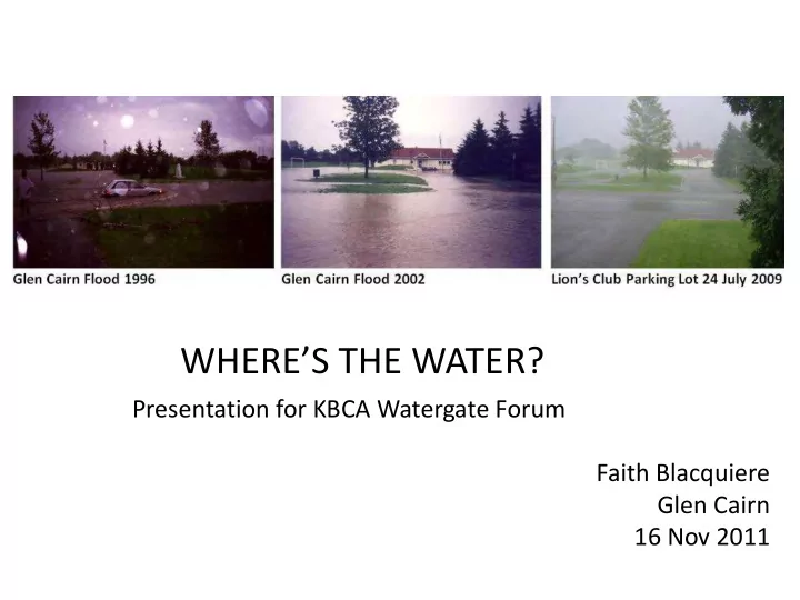
WHERES THE WATER? Presentation for KBCA Watergate Forum Faith Blacquiere Glen Cairn 16 Nov 2011 This Presentation GCFI ESR Pg 54 Asks Wheres the Water? and Wheres the Wastewater? In your basement? On your street? In a parking lot?


  1. WHERE’S THE WATER? Presentation for KBCA Watergate Forum Faith Blacquiere Glen Cairn 16 Nov 2011

  2. This Presentation GCFI ESR Pg 54 • Asks Where’s the Water? and Where’s the Wastewater? In your basement? On your street? In a parking lot? In a Stormwater Management Pond? In a ditch? In the River or floodplain? In a pipe that has capacity? • Identifies problems and issues which need to be resolved • Identifies what’s needed to resolve some of them 1

  3. Problem: Flood Investigations Don’t Focus on Watershed and Sewersheds and “What Changed?” All of the infrastructure systems interact within their watersheds and sewersheds Problem: Flood Investigation focus on 1 or 2 systems results in problems and solutions being overlooked Problem: Not asking whether flood water is storm or sewage 2

  4. Problem: Diverted watercourses may still follow the old path – GCFI Archaeological Assessment used wrong path to determine archaeological potential 3

  5. Problem: Where are the Carp River Headwaters? All the studies since 2000 have said the Carp River Headwaters are near the Glen Cairn Pond: * Carp River Watershed/Subwatershed Study * 2 Flow characterization studies * Kanata West and Fernbank CDPs * Third Party Review * Carp River Restoration Plan EA The City and MVC inform consultants that the headwaters are in the Glen Cairn Pond/Fernbank lands when they are in Stoney Swamp Where are the Poole Creek Headwaters now that the wetlands and tributaries have been changed to the Hazeldean Municipal Drain? Questions that Need to Be Answered What impact does this misunderstanding have on modelling and analysis? What impact does out-of date mapping have on analysis? 4

  6. Problem: Out-of Date Maps – Where’s the Development? Bishop Report 1997 CCL Report July2003 vol 1 pg 20 CCL Mar 2003 vol 1 pg 64 Problem: consultants not aware of 1991 infill development or development in process 5

  7. Problem: Floodplain Mapping and Models were updated without review of impact on infrastructure Why did Glen Cairn flood in 2009? 1. Glen Cairn Pond built for 94.72m in 1972; Regulatory Flood level changed to 95.5m in 1983 without review or upgrade 2. 2003 Mitigation didn’t consider impact on storm outfalls 3. Antecedent water levels not included in models 6

  8. Problem: Village of Carp and downstream reaches not included in plans On 13 Oct 2009, Don Moss of Greenland told PEC: Measured water levels were 0.9m below 100 year flood levels at the Village of Carp Ottawa Citizen 27 July 2009 eMAP Problem: Where’s the Water? Not in the channel that is modelled Problem: Floodplain is increasing in size due to upstream development and/or downstream constraints Problem: 11/12 April 2011 minor storm caused flooding at Village of Carp Problem: Landowner permission not obtained and landowners not compensated when floodplain expands on their property 7

  9. Problem: The Carp River Watershed/Subwatershed Study 2004 is saying “stormwater quantity control” is not required But the Study also says: • Future flows will still be contained within in the valley lands and the Carp River shows no significant increase in peak flows • Total runoff volumes will increase and this could affect the frequency of higher than normal flows in downstream reaches • The change in total runoff volume should be investigated as part of the functional design of the Carp River Corridor Plan So, are they are saying • It’s ok to flood the valley lands? • The Carp River may show no increase because the banks were overtopped? The Carp River Restoration Plan ended at Richardson Side Road and didn’t include restoration or downstream impacts 8

  10. Problem: Different rules for ICI, condos, and other private property Facebook Group – Castle Glen rearyards 24 July 2009 Problem: City SWM policy uses rearyard swales to drain the area - Homeowners or developers build tight fences stopping the flow Problem: the City generally won’t address flooding problems on private property Problem: catchbasins on private property also are landowner responsibility but may impact others 9

  11. Problem: Sediment and vegetation reduce stormwater infrastructure capacity Can stormwater infrastructure and “natural channels” co-exist? What happens to the natural channel when sediment and vegetation reduce the design capacity? How much water is displaced? Where will excess rainfall go? 10

  12. Problem: Dry Weather Flow in SWM infrastructure How much water should be in culverts in dry weather? What happens in winter with ice build-up? Where does rainfall go if the culvert capacity has already been used? 11

  13. Problem: Beaver control of SWM infrastructure Why does the City let beavers take control of essential infrastructure? Why doesn’t the City use beaver-friendly technologies? Why aren’t Impact Studies mandatory before beaver dams are removed? Why are works under the Drainage Act treated differently? 12

  14. Problem: Different approval authorities for SWM projects and EA changes after public consultations TFDE 20110411 Carp River Bridge 20110930 TFDE SWM infrastructure and wetlands differed from the EA and were approved only by MVC unlike the Monahan Drain Wetland infrastructure which is approved by MOE Carp River Bridge and stormwater outlet – no MOE Certificate of Approval located 13

  15. Problem: Kanata West’s Carp River Restoration Plan • Not considering all conditions DWF, WWF & extremes • Compromised Glen Cairn Flood Solutions • 5 models vs 1 cause problems in calibration/validation • Hazeldean Carp River Bridge construction impacted flow to monitors used for calibration/validation • Inline SWMPs and wetlands impact flows • Upstream and downstream impacts not considered • Impact on existing storm outfalls not considered • Boundary conditions for Glen Cairn Pond need confirmation 14

  16. Problem: 250 Year Floodplain Mapping not being considered for Climate Change impact UWO. City of London Vulnerability of Infrastructure to Climate Change Sep 2009 Pg 127 Figure 3.6 Location of special concern at the North Thames River Why are the City and Province not requiring 250 year modelling - at least for sensitivity analysis – to determine the impact of climate change on flood-prone areas? What will be the impact of climate change on the existing and planned infrastructure? 15

  17. Problem: New mapping technology is not being used for SWM retrofitting and for development planning The Technology is here, which shows overland flow routes, ponding areas, and tributaries Why isn’t the City using this technology to identify areas at risk and for planning new developments? Why aren’t developers required to look outside the local site? 16

  18. Problem: Entombing Watercourses in Culverts There is a movement in urban areas to rediscover connections to nature and the past that have been lost for decades. Daylighting refers to the deliberate effort "to expose some or al1 of the flow of a previously covered river, creek or storm water drainage. (Pinkham, 2000 ). Castlefrank/Rickey Place entombed culvert daylighted due to flooding Granite Ridge outlet and drains to be entombed, cutting off Iber Road ditch drainage system 17

  19. Problem: Diverting watercourses and filling wetlands Watercourse, wetlands or ponds in the way of development? Fill them in (don’t tell the buyers or give them basements) or divert the watercourse to someone else’s land eMAP 2002 vs 2008 Hazeldean Creek 2002 vs 2008 eMAP 2008 Richardson Lands 20091106 Cope Drive at Terry Fox 18

  20. Problem: No Wet Weather Policy • RMOC identified the need in the late 1990s for a Wet Weather Strategy and Plan, and Extraneous Flow Programs • City of Toronto Wet Weather Flow Management Plan was developed between 1998 and 2003 and includes Policy, Guidelines, and 25 year Project Plans. In 2011 Council was asked to authorize funding for 32 identified Chronic Basement Flooding Study Areas • City of Ottawa focus is currently on developing the Wet Weather Strategy as part of ORAP solutions Inside the Greenbelt • Essential water management and flood protection policies are being delayed due to staff being kept too busy reacting to floods How can the suburbs compete with the multi-million dollar CSO solutions and the old City of Ottawa needs? Why can’t the City use the Toronto plans and modify them? 19

  21. Problem: Ditch Systems Ignored in Planning GCFI ESR pg 54 Terry Fox Drive at Trans Canada Trail 24 July 2009 • West End Flood Investigation is fixing some, not all, ditch systems which caused flooding • Servicing studies send water to ditches with no ultimate outlet identified and with no impact analysis • City staff not aware of engineered ditches and their role in stormwater management • Ditches and low points not being managed with other SWM infrastructure 20

Download Presentation
Download Policy: The content available on the website is offered to you 'AS IS' for your personal information and use only. It cannot be commercialized, licensed, or distributed on other websites without prior consent from the author. To download a presentation, simply click this link. If you encounter any difficulties during the download process, it's possible that the publisher has removed the file from their server.

Recommend


More recommend