Wednesday 11:00 AM Room(s) 13, 14, and 15 Level Intermediate Dennis - - PDF document

wednesday 11 00 am room s 13 14 and 15 level intermediate
SMART_READER_LITE
LIVE PREVIEW

Wednesday 11:00 AM Room(s) 13, 14, and 15 Level Intermediate Dennis - - PDF document

Presentation Agenda Start Room 13 Room 14 Room 15 Time Education Gov and Public Works Vendor UAS: Their Many Uses; Present Cost-Effective Map Multi-Hazard Risk Portfolio Services for the and Future (MHRP) 1:00 Community - Tipton PM


slide-1
SLIDE 1

Presentation Agenda

Start Time Room 13 Education Room 14 Gov and Public Works Room 15 Vendor

Wednesday, April 27

1:00 PM

UAS: Their Many Uses; Present and Future Cost-Effective Map Services for the Community - Tipton County GIS Board

Multi-Hazard Risk Portfolio (MHRP) 1:30 PM

Developing Cross Platform Mobile Apps with Cordova Using GIS to Manage Asphalt and Mowing Projects for Tipton County Public Works

Reducing Paper With the Help of GIS Technologies 2:00 PM

Visualizing Neighborhood Indicators Streamlined Utility System Management with ArcGIS Online Shelby County Traffic Signal Infrastructure in GIS

3:00 PM

An (Unbiased) Comparison of Open Source and Proprietary Solutions for Enterprise GIS in the Public Transportation Field Presentation Brief: HIFLD Programmatic & Data Update LiDAR Hydro Derivative Project

3:30 PM

Managing and Implementing a Regional Resource Inventory for THRIVE 2055 Regional Planning Project Area Town of Collierville’s SMARTGov cloud-based permit management solution Getting the Best Accuracy from Esri’s Collector App

slide-2
SLIDE 2

Presentation Agenda

Start Time Room 13 Education Room 14 Gov and Public Works Room 15 Vendor

Thursday, April 28

8:00 AM

Using the ESRI Story Map Platform for Public Outreach Making the Case for Multiple- Benefit Linear Park Investments: The Healthy Connected Chattanooga mapping platform and its implications for public health and community connectivity. Knox County MS4 Stormwater GPS/GIS Inventory

8:30 AM

Teaching GIS using Stormwater Pollution Prevention Plans (SWPPP) Rocking GIS Apps for a Rocking City Point Cloud Density. How important is it?

9:30 AM

TBA The Park Locator The Changing Geospatial Landscape

10:00 AM

Geography Education in Tennessee – TNGIC Has a Horse in this Race Building an Online Customer Response Work Order System Utilizing Lidar in Tennessee

Start Time Rooms 13, 14, and 15 ESRI

slide-3
SLIDE 3

2:30 PM

Introduction to the ArcGIS WebApp Builder: JavaScript Apps Made Easy

3:00 PM

Introduction to mobile solutions for the ArcGIS Platform

2016 TNGIC Conference Presentations

Wednesday 11:00 AM Room(s) 13, 14, and 15 Level Intermediate Presenter(s) Dennis Pedersen Abstract Title State of Tennessee GIS Coordination Update Abstract The Department of Finance and Administration, GIS Services group is continuing its efforts to bring statewide LIDAR coverage to Tennessee. This presentation will address the project status in two regions of the State and also discuss the data dissemination, data access solutions for GIS users across Tennessee. The presentation will include a demonstration of how to access LIDAR data from the Tennessee GIS Clearinghouse as well as the feasibility of hosting dynamic LIDAR services. Wednesday 1:00 PM Room(s) 13

Level

Beginner Presenter(s) Austin Ramsey Abstract Title UAS: Their Many Uses; Present and Future Abstract UAS have become an explosive technology that is used today in many applications. In this presentation, some of the uses of UAS will be explained. Furthermore, we will discuss the future of UAS and the rules and regulations that the FAA has set up. Wednesday 1:00 PM Room(s) 14 Level Beginner

slide-4
SLIDE 4

Presenter(s) Bob Beanblossom Shawn Anderson Abstract Title Cost-Effective Map Services for the Community - Tipton County GIS Board Abstract GIS has been a very important component of Tipton County Government since 2000 and has

  • ffered many opportunities for cost savings and geographic knowledge for us ‘Country Folks’. The

presentation will give a brief history and outline of who we are, what our members are doing and what lies ahead in the future. Wednesday 1:00 PM Room(s) 15

Level

Intermediate Presenter(s)

Mike Camponovo

Abstract Title Multi-Hazard Risk Portfolio (MHRP) Abstract With the fifth largest land area but 45th lowest population density, New Mexico needed to develop a way to prioritize hazard mitigation projects that was objective, repeatable, and transparent to best utilize limited financial resources. The New Mexico Silver Jackets deployed the first phase of the Multi-Hazard Risk Portfolio (MHRP) to assess watershed based flood risk across the state on a variety of factors. The tool includes a desk reference; watershed aggregated interactive story map, and interactive reference map. The tool has been used to prioritize lidar purchases and sequence watersheds for FEMA's Risk MAP program. The MHRP is expanding this year to include watershed based wildfire risk, and pending availability of funds, will expand to include additional hazards in ongoing years. The presentation will highlight the collaborative role of developing an inter-agency tool such as the MHRP, specific geospatial and hazard inputs for the tool, and lessons learned that will be applied in future versions. Wednesday 1:30 PM Room(s) 13 Level Intermediate Presenter(s) Bruce Ralston Abstract Title Developing Cross Platform Mobile Apps with Cordova Abstract Cordova is a Free and Open Source Software (FOSS) platform for developing apps that run on several platforms, including iOS and Android. It leverages the power of HTML5, JavaScript, and

slide-5
SLIDE 5

CSS to develop cross platform applications. If you can build a simple web page, you can develop mobile apps with Cordova. It works with both FOSS mapping standards, such as Open Layers and Leaflet, and with commercial mapping platforms such as Google Maps and ArcGIS Services. This presentation will go over how to install and use Cordova for mapping apps. An example app will be developed, along with some useful resources for getting started with Cordova. Wednesday

1:30 PM

Room(s) 14 Level Beginner Presenter(s) Dwayne Coley Abstract Title Using GIS to Manage Asphalt and Mowing Projects for Tipton County Public Works Abstract This presentation will offer ways the Tipton County Public Works Department has used GIS to manage costs and improve efficiency for asphalt and grass mowing projects. Wednesday 1:30 PM Room(s) 15 Level Beginner/Inter Presenter(s) Chris Holder and Greg Butler Abstract Title Reducing Paper with the Help of GIS Technologies Abstract Hixson Utility District currently tracks repairs and maintenance done in our 26,000+ customer service area with paper work orders. With the help of our existing GIS, and other new and upgraded software platforms, the District plans to "go green" and significantly reduce paper output while better cataloging the work being done. Wednesday 2:00 PM Room(s) 13 Level Intermediate Presenter(s) Nate Ron-Ferguson Abstract Title Visualizing Neighborhood Indicators Abstract Most neighborhood “dashboards” restrict users to a single geography when reporting community

slide-6
SLIDE 6

indicators, limiting the user's ability to understand the state of their community in a larger context. WhereWeLiveMidsouth.org was a one year effort by the Center for Applied Earth Science and Engineering Research at the University of Memphis to design a system that enables users to compare communities across a variety of measurements and a range of geographic scales in

  • rder to achieve a more complete and holistic understanding of neighborhood health. This talk will

delve into the tools, processes, and methods required to pull a massive collection of data from federal, state, and local sources spanning 5 geographic scales and wrangle it into a format that is navigable, consumable, and coherent to its users. In addition to diving into some of the inner workings of the project, time will also be spent showcasing the final application. Wednesday 2:00 PM Room(s) 14 Level Intermediate Presenter(s) Mike Brewer Nick Lawalin Abstract Title Streamlined Utility System Management with ArcGIS Online Abstract Over the last several years, Mike Brewer has presented on his migration from his paper utility system to a more advance and up to date GIS system. Mike will offer an update and cover the Poplar Grove Utility System processes from the field to the office using ArcGIS Online with real time observations. He will also examine benefits, trials, tribulations and cost saving triumphs since implementation. Wednesday 2:00 PM Room(s) 15 Level Intermediate Presenter(s) Justin Abart Abstract Title Shelby County Traffic Signal Infrastructure in GIS Abstract In 2001, Shelby County and the City of Memphis entered into a contract with Tennessee Department of Transportation (TDOT) to begin implementing intersection improvement projects that qualify for funding under the Congestion Mitigation Air Quality (CMAQ) program. CMAQ is a federally funded program to improve air quality by employing measures that reduce traffic congestion. A few examples of

slide-7
SLIDE 7

intersection improvements eligible for funding under this program include operational upgrades for signalized and unsignalized intersections, signal system coordination, addition of left and right turn lanes and installation of traffic signal actuation and emergency vehicle preemption devices. SSR has been involved with the signal system coordination efforts and implementing the infrastructure information into a Geographic Information System (GIS). As a result, this geodatabase has served as a platform for technicians in the field making traffic signal maintenance calls as well as TN811 utility location. This presentation will cover the background of the CMAQ project and the implementation of GIS. Wednesday 3:00 PM Room(s) 13 Level Intermediate Presenter(s) Nathan Hilbert Abstract Title An (Unbiased) Comparison of Open Source and Proprietary Solutions for Enterprise GIS in the Public Transportation Field Abstract GIS is all about having the right tools for the job. Many organizations have taken a hard line on solely investing their time and money in either open source or proprietary solutions without much calculation of ROI. I will explore four core business processes of GIS in the public transportation field including setup and management of services, web map application development, desktop data editing, and analysis. Each process will be laid out in two parallel tracks; open source and

  • proprietary. A scorecard for each will be tallied as I discuss software choices, time, money, utility,

and complexity. Hopefully, there will be plenty of insights as we review the results. This presentation is ideal for business analysts, managers, directors, and those that are interested in how the other side approaches a problem. I will try to keep the technical jargon to a minimum, but cannot provide guarantees. Wednesday 3:00 PM Room(s) 14 Level Beginner Presenter(s) Julie Sokol Sarah Spalding Abstract Title Presentation Brief: HIFLD Programmatic & Data Update Abstract The Homeland Infrastructure Foundation-Level Data (HIFLD) Subcommittee is a formal interagency governance body serving the Federal Geographic Data Committee (FGDC). It was established in 2002, and today serves as a coordinating body to help improve the collection, processing, sharing, and protection of foundational geospatial information about critical infrastructure and key resources for the Nation. The HIFLD Subcommittee works across multiple levels of government to develop and distribute common foundation geospatial information to be used within the Homeland Security, Homeland Defense, Emergency Preparedness, and Community Resiliency mission areas. This presentation will provide a programmatic update on the latest status of HIFLD, new dissemination portals (i.e. HIFLD Open) as well as to discuss future direction on data enhancements efforts that are underway.

slide-8
SLIDE 8

Wednesday 3:00 PM Room(s) 15 Level

Beginner/Inter

Presenter(s) Tim Blak Abstract Title LiDAR Hydro Derivative Project Abstract The presentation will provide an overview of Atlantic’s most recent LiDAR derivative project for Weakley County E-911 and the City of Martin, Tennessee. Since the beginning of the Atlantic – Weakley County E-911 partnership, there has been one recurring theme – innovation – with one mindset – we can do this. The project deliverables included the development of a countywide shaded relief base map (customized) as well as a hydro derivative add-ons. Atlantic will discuss the preliminary design incentive, the creation of their innovative workflow, samples of the final deliverables. In addition, examples of how Weakley County E-911 utilized the LiDAR derivatives in the field during their search and rescue missions throughout the harsh winter months this year (2016). Wednesday 3:30 PM Room(s) 13 Level Advanced Presenter(s) Charlie Mix Abstract Title Managing and Implementing a Regional Resource Inventory for THRIVE 2055 Regional Planning Project Area Abstract THRIVE 2055 is an ambitious regional planning project of the 16 county Chattanooga area involving several working partners from various industries and backgrounds working to ensure sustainable growth for the region, with an emphasis on environmental conservation, economic development, transportation and education. UTC GIS maintains a regional resource inventory of geospatial data and resources that supports THRIVE 2055 and other projects. This presentation will describe the regional resource inventory, analysis and modeling being performed with this data and how the greater GIS community can leverage and access this valuable resource for their needs. Wednesday 3:30 PM Room(s) 14 Level Intermediate Presenter(s) Kevin Bingham Abstract Title Town of Collierville’s SMARTGov cloud-based permit management solution Abstract In the summer of 2015 Collierville’s Code Enforcement Division decided to invest in a cloud-based permit management solution called SMARTGov. From the project’s beginning it was expected that geospatial information would be an integral part of this solution. The challenges of integrating

slide-9
SLIDE 9

geospatial information included incorporating the most recent parcel data, providing access to

  • ther geospatial data layers, and accounting for permits on new properties without a parcel
  • number. In this presentation we will discuss and demonstrate how geospatial information has

been integrated with the SMARTGov permit management solution. Wednesday 3:30 PM Room(s) 15 Level Intermediate Presenter(s) Tiffany Puett Abstract Title Getting the Best Accuracy from Esri’s Collector App Abstract This presentation is for users interested in using the Collector app for field data collection. The purpose of this presentation will be to demonstrate how to get the best GNSS positional accuracy from data collected with Esri’s Collector app.Topics will include how to choose the best datum and projection, the benefits of real-time differential correction, the contrast of accuracy thresholds as well as the best way to set up a project in ArcMap for quality control. Thursday 8:00 AM Room(s) 13 Level Beginner Presenter(s) Michael Camponovo Abstract Title Using the ESRI Story Map Platform for Public Outreach Abstract The ESRI Story Map platform is an effective tool for developing interactive maps and websites for public

  • utreach that is already included in your ESRI license. This presentation will highlight specific

examples used in New Mexico for hazard outreach and planning including "Impacts of September 2013 Flooding in New Mexico", "Turn Around Don't Drown New Mexico", and the watershed aggregated results for the New Mexico Multi-Hazard Risk Portfolio. The presentation will also provide tips and lessons learned for more effective use of the platform as well as examples for

  • ther disciplines. If time allows we will build a story map live.

Thursday 8:00 AM Room(s) 14 Level Beginner Presenter(s) Noel Durant Abstract Title

slide-10
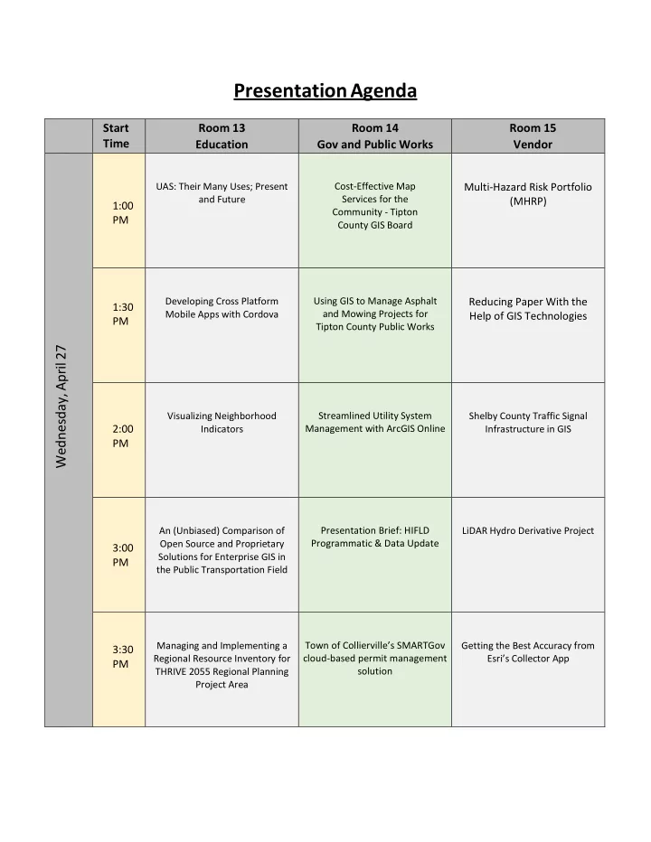
SLIDE 10

Making the Case for Multiple-Benefit Linear Park Investments: The Healthy Connected Chattanooga mapping platform and its implications for public health and community connectivity. Abstract This presentation will be focused on the Trust for Public Land’s Healthy Connected Chattanooga mapping tool, and the subsequent success of this tool in securing funding for recreational investments to improve public health. This online mapping platform incorporates The Trust for Public Land’s Climate-Smart Cities program priorities with an equity and public health analysis of park distributions across Chattanooga. This presentation will include examples of how this online mapping platform’s outputs have been used successfully in public funding request to demonstrate the need for investment in underserved communities in Chattanooga. There will be a live demonstration of the mapping platform, as well as a Q & A on the trends in data driven decision making for more resilient communities. Thursday 8:00 AM Room(s) 15 Level Beginner/Inter Presenter(s) Rob Hench Cathy Olsen Abstract Title Knox County MS4 Stormwater GPS/GIS Inventory Abstract The presentation will cover the 2015 Knox County MS4 stormwater inventory project. The project covered approximately 170 square miles of Knox County and included over 36,000 stormwater structures, over 22,000 stormwater pipes/culverts and over 1,300 miles of drainage ditches and

  • channels. The project also included approximately 75,000 hyperlinked photographs and sketches
  • f the stormwater structures. Key aspects of the project that will be addressed in the presentation

include the regulatory requirement to conduct the inventory,GPS/Field data collection, stormwater structure inventory, LiDAR processing, GIS processing, GIS Deliverables and Quality Assurance/Quality Control and a description of how the data products will be used by Knox

  • County. The presentation will begin by covering the detailed project workflow and will conclude

with a live demonstration of the final ArcGIS Geodatabase and associated GIS deliverables. Thursday 8:30 AM Room(s) 13

Level

Beginner Presenter(s) Joanne Logan Abstract Title Teaching GIS using Stormwater Pollution Prevention Plans (SWPPP) Abstract Stormwater Pollution Prevention Plans (SWPPP) are a great resource to use to teach a college-level introductory GIS class in Soil and Water Science. Key GIS concepts such as map layers, adding data, classifying and symbolizing, heads-up digitizing, field data collection with GPS and mobile apps, map layouts, spatial analyses, and online mapping

slide-11
SLIDE 11

are all covered in the process of developing the maps and analyses used for SWPPP

  • reporting. A sample project work flow will be presented.

Thursday 8:30 AM Room(s) 14 Level Intermediate Presenter(s) Mickey Park Jessica Hendrix Bimal Shah Abstract Title Rocking GIS Apps for a Rocking City Abstract The City of Chattanooga Public Works GIS has used ESRI ArcGIS Server web mapping tools since 2005 along with various Desktop GIS Mobile solutions. But now with the latest technology improvements of ESRI ARC GIS Server, Microsoft 2014 SQL Server Reporting tools and HTML5 mobile apps and the expert help of a consultant (NUORIGIN, Brentwood, TN) for some custom development the Public Works Engineering Department has been able to supercharge our Mobile GIS capability. By leveraging in house GIS Staff and using out of the Box ESRI Collector and ArcGIS Web Solutions to fit the basic needs of most users, and developer tools to customize out of the box solutions we have been able to solve multiple Mobile GIS data collection and robust reporting needs for our Water Quality Management Asset Inventory, Water Quality Stormwater Control Measures, Sanitary Sewer Overflow live mobile tracking and reporting tools, Public access maps with Live real time Snow Plow/Salt and Brine vehicle tracking, Leaf Collection vehicle Tracking, Garbage Collection vehicle tracking. These GIS tools have improved staff efficiency, time management and our operational work flows tremendously. Thursday 8:30 AM Room(s) 15 Level Beginner Presenter(s) Nancy Graham Abstract Title Point Cloud Density. How important is it? Abstract Historically, one of the most important specifications of point cloud data (typically from LIDAR) is “Density”. Point cloud density (or its reciprocal, Nominal Point Spacing NPS) is one of the more important parameters affecting the applications for which data can be used as well as the procurement cost. Recently, the USGS has developed a set of standard density/accuracy “brackets” to quickly categorize data. In this paper, we will examine how point density affects the ways data can be used, the levels of densities covered by the USGS specifications, as well as specialized applications that might require “buy-ups” outside these standard Quality Levels. We will also briefly discuss how density affects the “total cost of analysis”. Thursday 9:30 AM Room(s) 14 Level Beginner Presenter(s) Bill Avant Tim Buchanan Abstract Title

slide-12
SLIDE 12

The Park Locator Abstract The Park Locator is a configuration of ArcGIS and a JavaScript application that allows citizens to locate park and recreation opportunities in their community from a smartphone, tablet, and desktop computer. Park Locator is typically used by parks and natural resources departments, or other state government

  • rganizations responsible for managing parks and recreation activities. This application provides

access to the public 24 hours a day, seven days a week for the public to discover recreational activities. The Trail Mapping Initiative is to first and foremost make sure that every state park has an accurate, to scale, professional looking trail map that will better communicate to our visitors the trails of the park that can be enjoyed. A template of the trail map has been created and the template should be utilized at every park. The most general reason to have standards is to create a strong TDEC/State Parks brand, so that the work is easily recognizable by the public. Cartographic standards also provide other advantages that will be reviewed in this presentation. Thursday 9:30 AM Room(s) 15 Level Beginner Presenter(s) Jeff Lovin Abstract Title The Changing Geospatial Landscape Abstract This high level presentation will discuss change that is occurring in the geospatial industry and how it is shaping our world through consolidation, SaaS and new sensors coming to market like Geiger and Photon Lidar, using the cloud, 3D Mapping, UAS and how to leverage all of this data. Thursday 10:00 AM Room(s) 13 Level All Presenter(s) Kurt Butefish Abstract Title Geography Education in Tennessee – TNGIC Has a Horse in this Race Abstract In 2013, for all intents and purposes, the Tennessee State Department of Education removed meaningful geography content from the K-12 curriculum. Realizing the negative impact this will have on undergraduate enrollment in geography programs and the potential impact on developing

slide-13
SLIDE 13

qualified geospatial professionals, the presenter and his organization are working with all stakeholders to reverse this short-sighted decision. Come learn about what is being done and how you can assist by giving a much needed voice to the geography and geospatial technologies professional communities. Thursday 10:00 AM Room(s) 14 Level Beginner/Inter Presenter(s) Julian Burke Abstract Title Building an Online Customer Response Work Order System Abstract This presentation will cover the problem faced by Chatsworth Water Works Commission (CWWC), a water/wastewater utility located in Chatsworth, GA and the development of a web based software solution. Thursday 10:00 AM Room(s) 15 Level Intermediate Presenter(s) Sam Moffat Abstract Title Utilizing Lidar in Tennessee Abstract In this session, Woolpert will discuss the various uses of Lidar and other geospatial data and the benefits obtained from large scale Lidar data coverage for The State of Tennessee, TVA and local county governments. We will explore how to leverage the 3D Elevation program (3DEP) that is managed by the USGS and funded through FEMA with the goal of acquiring QL2 Lidar data over the entire U.S. every eight years. We will highlight the exciting future of remote sensing that includes rapid automated feature extraction techniques that is used in various emerging technologies such as augmented reality and hydrographic modeling. Thursday 2:30 PM Room(s) 13, 14, and 15 Level Intermediate Presenter(s) William Meyers Abstract Title Introduction to the ArcGIS WebApp Builder: JavaScript Apps Made Easy Abstract Using Esri's HTML5/JavaScript based application gives you the power to create your own beautiful, fast and intuitive web applications. This presentation will demonstrate the ability to consume ArcGIS for Server hosted services in ArcGIS Online and open data to create a configurable web application using WebApp Builder.

slide-14
SLIDE 14

Thursday 3:00 PM Room(s) 13, 14, and 15 Level Intermediate Presenter(s) William Meyers Abstract Title Introduction to mobile solutions for the ArcGIS Platform Abstract This presentation will show you how to leveraging Esri's Mobile Solutions by empowering your mobile workforce, giving the right information, on the right device, anytime and anywhere. The products and solutions to be demonstrated include; Workforce for ArcGIS, Collector for ArcGIS, Navigator for ArcGIS and Survey123.