
SLIDE 1
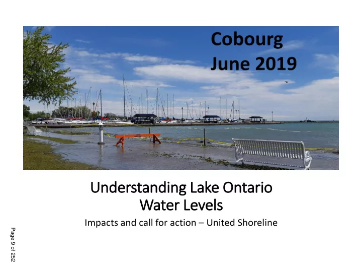
Understanding Lake Ontario Water Levels
Impacts and call for action – United Shoreline
Page 9 of 252
Water Levels Impacts and call for action United Shoreline Page 9 of - - PowerPoint PPT Presentation
Understanding Lake Ontario Water Levels Impacts and call for action United Shoreline Page 9 of 252 4) When Ottawa and Montreal are flooding, L.O outflows are reduced and L.O rises. When levels are allowed to reach this extreme, they are
Page 9 of 252
1) 85% of Lake Ontario inflow comes from Lake Erie (record high) 2) Rain/Snow melt makes up the rest
inflow 3) The outflows into the St. Lawrence River is controlled by the Moses Saunders Dam in Cornwall 4) When Ottawa and Montreal are flooding, L.O outflows are reduced and L.O rises. When levels are allowed to reach this extreme, they are powerless to stop L.O.
Page 10 of 252
Lake Erie INFLOW: 8,140 m3/s Rain/Snow melt inflow (2,190 m3/s ) TOTAL NET SUPPLY (INFLOW) 10,330 m3/s 249.5 feet (+33” Long Term average) June 17th 2019 ‘OUTFLOW”: 10,400 m3/s (record-tying, ‘upper limit safe for ships’)
Page 11 of 252
There is something dramatically different in how lake levels are being managed in the spring (Jan - May) due to Plan 2014.
There have been similar high precipitation years, without this
CLIMATE.
DATA FROM: https://www.glerl.noaa.gov/data/dashboard/GLWLD.html?fbclid=IwAR39rhBhTS2-_5XZdCsC3Ii03iLOpLM2e9GzJW0zgW9V7D4G_h-COjW4qFc
Page 12 of 252
Page 13 of 252
Lake Ontario outflows are REGULATED. “Plan 1958DD” regulated
1950’s to 2016. Pla lan 2014 was introduced January 2017. Plan 2014 is designed to allow for “higher highs” and “lower lows”
periods of time.
6
Page 14 of 252
Plan 1958 regulated the lake to a 4 foot range
7
Page 15 of 252
The Old Plan (1958) More highs by design More lows by design
8
The New Plan (2014)
4 ft range
Page 16 of 252
9
They ‘could’ have released more water in the fall so we were lower coming into the spring (L. Erie record highs…). But Plan 2014 does not allow it. The levels are left high, by design.
Page 17 of 252
“Some of the benefits now [1958DD] …are the result of ad hoc, discretionary decisions by the International St. Lawrence River Board of Control. Plan 2014 will make these benefits more assured and predictable, by removing the discretionary aspect of many of these decisions and formally making them part of the Plan’s regulation rules.” (Pg. 10, Plan 2014) Plan 2014 will use the releases prescribed … until Lake Ontario levels reach specified high or low trigger elevations. If levels reach the high trigger levels, then the Board will… (deviate).” (pg. 32, Plan 2014)
10
Cobourg 2019
Page 18 of 252
11
“The board did not miss any
2018,” said Frank Bevacqua, public information officer for the
much water as possible, based on conditions in the St. Lawrence River.” May 22nd 2019, Watertown Daily Times
When they say they are releasing the 'maximum possible', they actually mean the maximum permissible by Plan 2014, not the maximum HUMANLY possible. THEY CANNOT DEVIATE until extreme triggers are reached.
Page 19 of 252
“Approximately 60% of the Lake Ontario and St. Lawrence River shoreline is …residential land use.” …an estimated 25,000 privately
located on Lake Ontario and the St. Lawrence River upstream of the Moses-Saunders Dam. More than 3,000 shoreline property parcels are located below elevation 76.2 m (250 ft) !!! and could be at risk of flooding ….” (Plan 2014, pg 42)
247.3 ft is the current flood stage
Page 20 of 252
13
Plan 2014, Pg. 45
Page 21 of 252
“Based on historical supplies, Plan 2014’s projected maximum level would be 2.4 inches (6 centimeters) higher than the maximum level under 1958DD --- about as tall as a tennis ball” Plan 2014 changes the real trigger levels for April, May and June by over a foot (30 cm), allowing the lake to go up a foot higher during the wet season and averaging it out with lower levels during the winter. A foot higher during unpredictable rainy seasons = more erosion and flooding
14
Plan 2014,
https://www.ijc.org/sites/default/files/2019-04/Plan2014.pdf
Page 22 of 252
The minimal "damage calculations" for Plan 2014 only considered the additional costs of shoreline protection structures on PRIVATE properties at 2005 dollar values.
emergency response damages to municipal infrastructure (roads, drainage, sewer) damages to public parks and beaches damages to properties on bays and creek inlets lost economic activity from shoreline businesses lost taxes due to decreased property values
15
Page 23 of 252
16
Page 24 of 252
CONDITIONS: “In Accordance with article VIII of the [1909 Boundary Waters] Treaty, interests on either side of the International Boundary that are injured by reason of the construction, maintenance and operation of the works shall be given suitable and adequate protection and indemnity as provided by the laws in Canada, or the Constitution and laws in the United States respectively.”
17
“The IJC is well aware that Plan 2014 will increase shoreline erosion and costs.”
Page 25 of 252
should not fall disproportionately on any
fall to the Lake Ontario shoreline
compensation measures should be in place prior to implementation.”
process with wide public participation.”
group that only consulted with environmental advocates. *Dr. Frank Sciremammano was a member of the IJC study and is a current member of the International St- Lawrence River Board of Control.
18
Brighton, 2017 Brighton, 2019
Page 26 of 252
× Plan 2014 puts your shoreline infrastructure built to Plan 1958DD at risk; × Plan 2014 will cost millions in coastal damages and emergency response; × Plan 2014 violates the IJC Study “Principle Guidelines” × Plan 2014 violates international treaty provisions for protection and indemnity. × Plan 2014 transfers the risk and the burden
(shoreline citizens), and to those with the fiduciary duty to protect them (Municipalities), without mitigation or compensation.
Toronto, Ontario Spring flooding, 2017
19
Page 27 of 252
20
Page 28 of 252
There are many elected
written such letters. The first of many promised class action lawsuits has been filed.
21
Page 29 of 252
Please consider passing a resolution requesting:
better protect the interests of Municipalities, Emergency Responders and Riparian's
to municipalities for flood prevention, preparation, mitigation, response and recovery
Treaty, protect and indemnify the Town of Cobourg and the town’s shoreline residents and business owners from all damages resulting from Plan 2014.
strike a committee to review mitigation and safety plans for the communities fronting the Great Lakes and St Lawrence Seaway
22
Brighton Ontario May 2019
Page 30 of 252
23
builds at local high schools.
wrapped in poly. It has taken heavy equipment and large daisy-chains of people to build walls over many weeks.
they meet weekly
Page 31 of 252
Plan 2014
24
Page 32 of 252
Water er flo flow and water le levels els are managed th through 2 loc locations on
the e Great La Lakes es-St. La Lawrence Riv iver er system. La Lake Ontario is is th the e lo lowest la lake of
the e Great La Lakes es Ba Basin, sep eparated fr from th the e upper er basin in by th the e la large drop at t Nia iagara Falls lls.
25
Page 33 of 252
states: The Study Board considered mitigation requirements for each of the candidate Plans. There were mixed views on this, with a Study Board majority determining that there were no disproportionate losses and, hence, that no mitigation was necessary for implementation of any of the Plans.
Plans fulfilled the Study Board Guidelines and principles, with a net improvement in ecological and economic benefits….
26
Colborne, Ontario, 2017
Page 34 of 252
27
study and is a current member of the International St- Lawrence River Board of Control.
Page 35 of 252
“The Study was conducted and reported in a manner biased against residents and businesses located on the shoreline and embayments of Lake Ontario; The Study lacks the scientific data, analysis and justification to reach the stated conclusions and recommendations; In reviewing the scientific basis for the Study conclusions, a special panel of the National Research Council concluded that the scientific work done is neither sufficient nor adequate to support the kind of decision-making attempted. Even if the above two factors are discounted, the Study recommendations represent poor public policy, ignoring essential social and economic considerations that should be factored into decisions regarding the operation
28
Page 36 of 252
We e cou
see Apr pril le levels els as as hig high or
higher tha than 247.3 247.3 (w (whic hich is is the the cur current flo flood
stag age) an and thes these catastrophic le levels els cou
emain for
5 mon
s in in a a row an and the the boa board woul
not be be req equired to
act. t.
29
Page 37 of 252