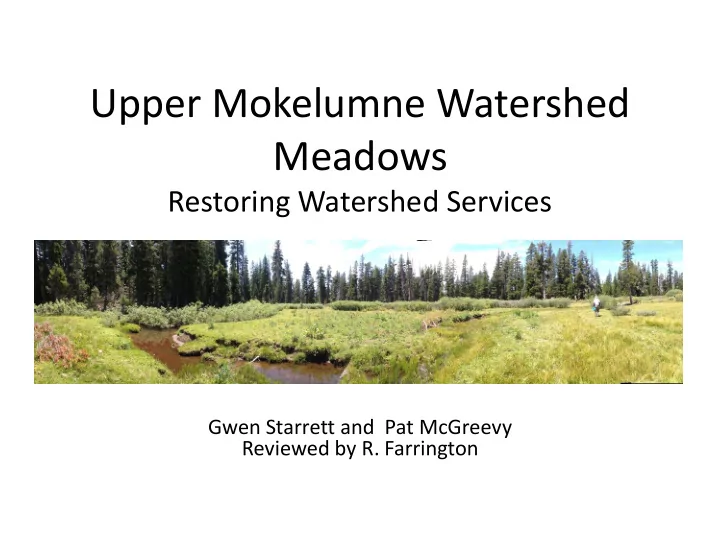
SLIDE 1
Upper Mokelumne Watershed Meadows
Restoring Watershed Services
Gwen Starrett and Pat McGreevy Reviewed by R. Farrington
SLIDE 2
Project Goals
▪ Increase pace and scale of restoration post- Cornerstone ▪ ACCG members take lead in funding and pre-project assessment ▪ Restore watershed services ▪ Restore hydrology ▪ Improve meadow habitat for sensitive species ▪ Improve stream habitat for sensitive species ▪ Improve grazing habitat long-term ▪ Build capacity for restoration work with local workforce
SLIDE 3
SLIDE 4 Tyler Meadow High Meadow
SLIDE 5 Sierra Nevada Yellow-legged Frog Habitat
High Onion
Tyler
SLIDE 6 Mokelumne Watershed Meadow Assessment
Meadow Name Bank Height Bank Stability Gullies outside Main Channel Vegetation Condition Bare Ground Encroachment Meadows rated by Starrett and McGreevy 2017 Upper Onion Valley 2.5 2.5 2 2 2 2 “High” Onion Meadow (Mdw_1734) 3 3 2 1 2 3 Tyler Meadow (Mdw_1737) 4 4 2 2 4 2 Meadows rated by Starrett, McGreevy, Long, and Childress 2015 Deer Valley 4 3 4 ND 1* 1 Ham Spring 2 1 1 ND 1* 3 “Tract Home” (MdwID_1794) 4 4 4 ND 2* 2 Meadows rated by American Rivers 2012 Pacific Valley 1 1 2 2 1 1 Indian Valley 1 2 1 2 1 2 Tryon Meadow 2 2 2 2 1 4 Little Indian Valley 2 3 1 3 2 3
1- heavily impacted 2 – moderately impacted 3- slightly impacted 4- natural condition ND- not determined
SLIDE 7 Upper Onion Valley Meadow
Area: 7.43 ac. Elevation 7458 ft. Weixelman ID: ELD9905 Riparian low gradient meadow
SLIDE 8 Upper Onion Valley Meadow American Rivers Score Card
1- heavily impacted 2 – moderately impacted 3- slightly impacted 4- natural condition Meadow Name Bank Height Gullies
Channel Bank Stability Vegetation Condition Bare Ground Encroachment Meadows rated by Starrett and McGreevy 2017 Upper Onion Valley 2 2 2.5 2 2 2
SLIDE 9 Upper Onion Valley Meadow American Rivers Score Card
1- heavily impacted 2 – moderately impacted 3- slightly impacted 4- natural condition Meadow Name Bank Height Gullies
Channel Bank Stability Vegetation Condition Bare Ground Encroachment Meadows rated by Starrett and McGreevy 2017 Upper Onion Valley 2 2 2.5 2 2 2
SLIDE 10 Upper Onion Valley
- Incised channels dewater meadow
(red arrows)
- Remnant channel (blue arrow)
SLIDE 11
8N03 Is a Stream Channel
SLIDE 12 Upper Onion Valley Meadow Dewatering Factors
- Road 8N03 captures water & sediment above
background rates & diverts into meadow
- Incised channels across top of meadow and along
full length of meadow
- Headcut migrating up meadow draining ponds
- Cattle contributing to bank instability
- Conifer encroachment lowering water table
SLIDE 13
Upper Onion Valley Restoration Considerations
– Disperse captured water off of 8N03 to reduce water/sediment transport to meadow – Raise water table by pond and plug – Return flows to remnant channel – Gradient control structure at outlet of meadow – Remove encroaching conifers from meadow
SLIDE 14 High Onion Valley
Meadow Name Bank Height Gullies
Channel Bank Stability Vegetation Condition Bare Ground Encroachment Meadows rated by Starrett, McGreevy, Childress and Long 2015 High Meadow 3 3 2 1 2 3
SLIDE 15 High Onion Valley
- Incised channel dewaters meadow
(red arrow)
- Remnant channel (blue arrow)
SLIDE 16 High Onion Meadow Dewatering Factors
- Roads transport water and sediment above
background accelerating channel incision & sedimentation
- Spread water off of roads
- Incised channels across top and south side of
meadow
- Gullies migrating to head of meadow
- Conifer encroachment
SLIDE 17
High Onion Meadow Restoration Considerations – Reduce water/sediment transport from roads – Channel remediation for incised channels: pond and plug – Return flows to remnant channel – Gradient control structure at outlet of meadow – Remove encroaching conifers from meadow
SLIDE 18 Onion Creek Drainages
- Deeply incised channels
- Redox soils indicate old
meadow
SLIDE 19
Onion Creek Drainages
SLIDE 20 Large Woody Debris Structures
- Sediment deposition upstream
- 3.5 foot elevation change
- Vegetation establishing in sediment
- Pool formed downstream
SLIDE 21 Natural Anchor Points for Woody Debris
- Woody debris – deposition and scouring
- Rock anchors
SLIDE 22 Tyler Meadow American Rivers Score Card
Meadow Name Bank Height Gullies
Main Channel Bank Stability Vegetation Condition Bare Ground Encroachment Meadows rated by Starrett and McGreevy 2017 Tyler Meadow (Mdw_1737) 4 2 4 2 4 2
SLIDE 23 Tyler Meadow
- Current channel (red arrows)
- Remnant channel (blue arrows)
- Road captures water, bypasses most
- f meadow (black arrows)
SLIDE 24 Possible In-Meadow Work
- Fill channel to direct flows
toward remnant channel
conifers
SLIDE 25 Tyler Meadow Aspen grove in thick conifers
cohort needed to maintain viability
browsing species? Need to take down and put up fence each season
prohibits log trucks
SLIDE 26
Tyler Meadow Restoration Considerations – Reduce water/sediment transport from 8N03F – Return flows to remnant channel – Fill or pond and plug incised channel – Remove encroaching conifers from meadow – Thin conifers from aspen grove upslope of meadow – Fence aspen area temporarily to protect from grazing
SLIDE 27 Overview of Meadows and Stressors
Meadow Name Road Channel Incisions Conifer Encroachment Cattle Grazing Upper Onion Valley
✓ ✓ ✓ ✓
High Onion MdwID_1734
✓ ✓ ✓
Onion Creek Drainage
✓
Tyler Meadow MdwID_1737
✓ ✓ ✓
SLIDE 28 Possible NEPA options for Project Work
NEPA Road Work Channel Repair Conifer Removal Fencing Cattle Grazing Upper Onion Valley CE 36 CFR 220.6(d)(4) EA for pond and plug CE 36 CFR 220.6(e)(7). CE 36 CFR 220.6(e)(6) ✓ Grazing Allotment High Onion MdwID_1734 CE 36 CFR 220.6(d)(4) EA for pond and plug CE 36 CFR 220.6(e)(7). Onion Creek Drainage CE 36 CFR 220.6(e)(7). Tyler Meadow MdwID_1737 CE 36 CFR 220.6(d)(4) EA for pond and plug CE 36 CFR 220.6(e)(7). CE 36 CFR 220.6(e)(6) ✓
SLIDE 29
ROAD PROJECTS
SLIDE 30 CE for Road Work
- (4) Repair and maintenance of roads, trails, and
landline boundaries. Examples include but are not limited to:
- (i) Authorizing a user to grade, resurface, and clean
the culverts of an established NFS road;
- (ii) Grading a road and clearing the roadside of
brush without the use of herbicides;
- (iii) Resurfacing a road to its original condition;
- (iv) Pruning vegetation and cleaning culverts along
a trail and grooming the surface of the trail; and
- (v) Surveying, painting, and posting landline
boundaries.
- Cite this category as 36 CFR 220.6(d)(4)
SLIDE 31
Road Conditions – 8N03
SLIDE 32
SLIDE 33
Possible Road Work
SLIDE 34
Rolling Drainage Dip
SLIDE 35 Estimated cost for erosion control on selected Cole Roads using a D4 Caterpillar Rolling Dips² Lead Off Ditches4 Estimated Road Date Locations¹ Cut Berms³ Touchups
5
Hours Cost6 8N03 12-Aug- 17 80 39 19 47 15 130 $13,000 8N03F Other Total 80 39 19 47 15 130 $13,000 Equipment Mobilization $1,500 Support Vehicle with Operator & Fuel $6,500 On-site Engineering Tech7 $10,000 Contingency 15% $4,650 Grand Total $35,650 1- Flagged & numbered work sites 2- Map of erosion control points: Mdws_8N03_Drainage_Lidar.jpg 3- Remove outside berm 4- Shape lead off ditches in/off road for drainage 5- Clean 15 lead off ditches selected by on-site engineer@ 1/2 hour each 6- D4 with operator: 130 hrs x $100/hr = $13,000 7- On-site engineering tech: 130 hrs x $75/hr = $10,000
SLIDE 36
MEADOW RESTORATION PROJECT
SLIDE 37 In-Meadow Work Upper Onion Valley, High Onion, Tyler
– Raise water table by pond and plug – Return flows to remnant channel – Gradient control structure at
– Remove encroaching conifers from meadow
Example of Pond and Plug Restoration – Indian Valley
SLIDE 38
STREAM RESTORATION
SLIDE 39 CE for Instream Woody Structures
- The following categorical exclusions are at
36 CFR 220.6(e).
- (7) Modification or maintenance of stream
- r lake aquatic habitat improvement
structures using native materials or normal
- practices. Examples include but are not
limited to:
- (i) Reconstructing a gabion with stone from
a nearby source;
- (ii) Adding brush to lake fish beds; and
- (iii) Cleaning and resurfacing a fish ladder
at a hydroelectric dam.
- Cite this category as 36 CFR 220.6(e)(7).
SLIDE 40 Goals for Placement of Unanchored Instream Wood Structures
Benefits:
- 1. Elevated stream bed over time by capturing sediment within
the incised stream reaches.
- 2. Increased habitat complexity by formation of step pools and
riffles.
- 3. Improved habitat for Sierra Nevada Yellow-legged Frogs by
creating pools that hold water year around.
- 4. Elevated groundwater table to support establishment of
riparian vegetation.
- 5. Reduced sediment transport to downstream sections,
including Upper Onion Valley meadow.
- 6. Attenuated peak flows in spring and extended base flow in
the summer.
SLIDE 41 Recommendations for stable unanchored woody structures
- 1. In channels <50 m bankfull width, wood with
diameter > or equal to 0.5 of the bankfull channel depth and wood length > or equal to 0.5 of the bankfull channel width (Roni et al. 2015).
- 2. Logs greater or equal to 12 inches in diameter and
logs greater or equal to 1.5 times the mean bankfull width (Flosi et al. 2010)
- 3. Root boles with diameters greater or equal to 5 feet
(Flosi et al. 2010).
SLIDE 42
Woody Structure Implementation
∙ FS fellers drop trees across the channel so that the crown of the tree is the basis of the woody debris. ∙ Drop a second bole across the crown to act as the key stabilizing feature. ∙ Keep flow to thalweg to reduce potential bank erosion ∙ Volunteers (Generation Green, Watershed Alive! team, ACCG members) add coarse woody debris, duff, small limbs to upstream side of structure ∙ Use natural anchors like granite boulders to stabilize structures
SLIDE 43
CONIFER ENCROACHMENT
SLIDE 44 CE for Conifer Removal in Meadows or Aspen Grove
- (6) Timber stand and/or wildlife habitat improvement
activities that do not include the use of herbicides or do not require more than 1 mile of low standard road
- construction. Examples include but are not limited to:
- (i) Girdling trees to create snags;
- (ii) Thinning or brush control to improve growth or to
reduce fire hazard including the opening of an existing road to a dense timber stand;
- (iii) Prescribed burning to control understory
hardwoods in stands of southern pine; and
- (iv) Prescribed burning to reduce natural fuel build-up
and improve plant vigor.
- Cite this category as 36 CFR 220.6(e)(6)
SLIDE 45
FUNDING POSSIBILITIES
SLIDE 46 Funding: Fire Settlement NFWF
Rule: Projects proposed for the use of settlement funds must meet the three criteria from 16 USC 579c defining how Fire Settlement Funds may be used:
- To conduct improvement, protection, or rehabilitation work;
- On lands administered by the Forest Service
- For purposes rendered necessary by the Fire cited in the Settlement.
Location
- Priority is within fire perimeter, or in close proximity to fire with closest suitable restoration
site taking preference
Purpose
- Watershed Restoration – where sufficient rationale is demonstrated to link impairments
from the fire to beneficial uses of water, water quality, or aquatic dependent species, proposed activities that mitigate these fire effects (i.e., road/trail decommissioning, road/trail maintenance or reconstruction, re-establishment of surface cover, etc.) may be an appropriate use of fire settlement funds.
- Activities that provide refugia proximate to the fire for displaced aquatic dependent species
may be an appropriate use of funds.
Nexus with NFWF Goals
SLIDE 47 California Department of Parks and Recreation Motorized Recreational Trail Program (RTP)
Purpose: Provide well managed OHV Recreation with maintain roads and facilities as well as wildlife, soils and habitat. Eligible Projects:
- Development & Rehabilitation of trails
- Construction of new trails
- Maintenance of existing trails
- Purchase or lease of trail construction & maintenance equipment
- Assessment of trail condition for accessibility & maintenance
- Projects must be listed on a local Transportation Improvement Plan
- (Does the ENF have a plan and list?)
No 2017 RTP grant cycle; Next cycle in fall of 2018
SLIDE 48 CDFW PROP 1 FUNDS
- July 2018
- $285 million statewide for watershed restoration
projects including mountain meadow restoration
- 10 years of funding, started in 2015
CORNERSTONE FUNDS
- Possible funding in 2018 or 2019
SLIDE 49 Water Board Supplemental Environmental Project (SEP)
- Dischargers fined under a Water Board action may fund a SEP with part of their fine
money
- Applicable projects include:
- studies or investigations
- habitat restoration or enhancement;
- pollution prevention or reduction;
- wetland, stream, or other waterbody protection, restoration or creation
- Nexus between violation and SEP
- Location
- ‘nature’
- Proposal sent to Central Valley RWQCB, public comment period, added to SEP list
- Discharger must choose SEP, so no timeframe for implementation
- Robert L'Heureux at (916) 464-4736 or Robert.LHeureux@waterboards.ca.gov.
SLIDE 50 Next Steps
Road Project
Meadow Restoration
- Construct 1 foot contour lines for restoration design
- Develop restoration protocols
Stream Restoration
- Survey streams for placement of instream structures
Conifer Encroachment
- Feasibility Assessment of Aspen Release
Funding
- Pursue funding possibilities with NFWF
- Pursue funding possibilities with Water Board staff (SEP)
Updates
- Bimonthly Progress to Planning Committee