update centennial trail boone to pettet route improvement
play

Update: Centennial Trail Boone-to-Pettet Route Improvement Boone - PowerPoint PPT Presentation

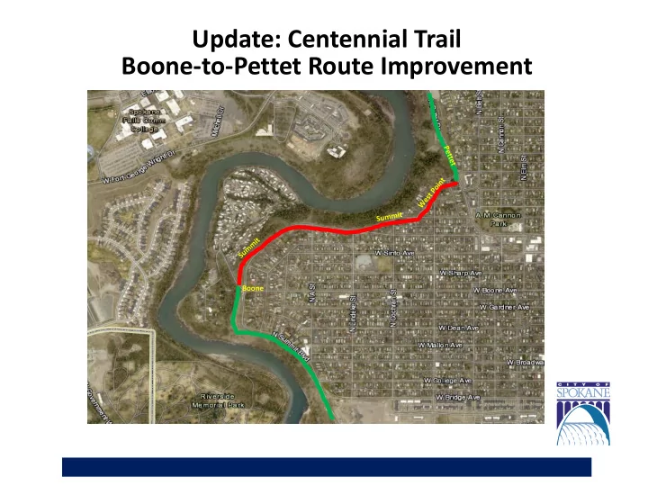
Update: Centennial Trail Boone-to-Pettet Route Improvement Boone Centennial Trail Boone-to-Pettet Route Gap Development History The City section of the Centennial Trail was routed years ago and signed in 2013/2014. Due to lack of


  1. Update: Centennial Trail Boone-to-Pettet Route Improvement Boone

  2. Centennial Trail – Boone-to-Pettet Route Gap Development History • The City section of the Centennial Trail was routed years ago and signed in 2013/2014. Due to lack of funding, portions of the route were identified as usable-as- is gaps and slated for future improvement. • The Boone-to-Pettet gap completion project was identified as a top recommendation in a 2007 study of all Centennial Trail gaps, links, and realignment projects. • The Project then was approved in the 2009 and 2015 Bike Plans and the 2018, 2019, and 2020 Streets programs. • Trail designation upgrade to Class 1 was approved in the 2017 City Comprehensive Plan. Class 1 requires a paved, ADA-compatible surface separated from traffic. • Trail maintenance responsibility requires cooperation between Friends of the Centennial Trail and City, County, Parks and State agencies. Route gap completion projects occur as funding and opportunity allows. • Two Congestion Mitigation and Air Quality (CMAQ) grants were awarded to the City in 2017 and 2018 for this project. The first grant ($150K) is being utilized for design. The second grant ($2.53M) will be utilized for construction. • Project design began October 2019. A public outreach meeting was held at Holmes Elem. November 21, 2019.

  3. Project Timeline

  4. Route Improvement Goal: Increase Safety Gap improvements provide a needed buffer between trail users and traffic on the Boone-to-Pettet section of the designated Centennial Trail. Mission Boone

  5. Route Improvement Goal: Buffer Zone Provide a 5-foot buffer between the trail and the street • Reduces ped/bicyclist/vehicle conflict • Maintains two-way traffic on Summit • Maintains street parking along the residential side of Summit • Maintains street parking along north side of Mission and west side of West Point

  6. Route Improvement Goal: Address Current Right-of-way Challenges • Provide safe access points to public transportation • Mitigate safety hazards • Address current substandard road design • Provide residential parking solutions

  7. • The existing trail route cannot safely accommodate ped/bicycle/vehicle use. • Pedestrians are often forced into the street. • Safety issues are exacerbated by the lack of sidewalk on the east side of Summit.

  8. • Existing route — bluff slopes reach 80% on the north end of Summit. • Erosion conditions necessitates providing 3.5-foot railings at critical points to prevent trail user injuries.

  9. • Existing road width is substandard. • By reducing parking on the west side, lanes and parking on the east side can be widened to meet standards. • Currently, cars are parking up on the sidewalk in order to avoid blocking traffic. • The re-design of the traffic lanes will maintain two-way traffic on Summit and reduce West Point to a one way. • The design eliminates the need to acquire private property and provides designated parking space for residents.

  10. Citizen Concerns The City received the following comments: The proposed trail will be 15- to 17-feet wide. The trail will be a standard 10- to 12-feet wide. Homeowners will lose a portion of their front yards. City engineers are working closely with specific property owners to develop acceptable solutions. The trail will cross over 17 driveways, creating a major safety hazard to homeowners. The current trail route is not changing. Liability will be reduced with the addition of bump-outs and curves to limit bicycle speed along West Point and Mission. The trail down Doomsday Hill is steep, dangerous, and the TJ Meenach bridge access is substandard. Trail sections beyond the Boone-to-Pettet gap are out of the scope of this project.

  11. Citizen Concerns The installation of a railing will be an eyesore and alter wildlife patterns. The 3.5-foot railing addresses a major safety concern where bluff edge comes close to the trail. It should have no negative impact to wildlife. Removal of trees and vegetation along the bluff will contribute to erosion. Any tree or vegetation removals will be evaluated by City engineers and arborists to determine if erosion mitigation is necessary. Allowing pedestrians and bicyclists to use the same trail will create dangerous conditions. As with all of the Centennial Trail, design complies with AASHTO/FHWA safety regulations. Grant requirements also address NEPA concerns to achieve a balance between population and resource use. The burden of snow removal will lie with the homeowners. For property abutting the trail, homeowners must adhere to the City Snow Response Plan (36-inch path). The new buffer zone will protect the trail from the plowing berm.

  12. Example Property Impact Property/City Right of Way line Approx. proposed outer edge of trail

  13. Example Property Impact Proposed optional property acquisition Current Property/City Right of Way line

  14. Citizen Concerns The trail improvements will alter the nature of the Historic Nettleton’s Addition. The historic district does not include the properties on the north side of W Summit, the north side of W Mission or those on N West Point. The district terminates at A Street. The project has been reviewed by HRA, SHPO, and WSDOT’s Cultural Resources Division. They have identified no direct impacts.

  15. Citizen-suggested Additional Route • The proposed additional route would be located in the undeveloped forested area along the bluff. • This proposed trail section would require the construction of a bridge across the Spokane River.

  16. Citizen-suggested Additional Route • Development of the additional route has already been identified in the City Comprehensive Plan for future trail expansion, but it has not been fully evaluated and is expected to have a large fiscal impact. • The Boone-to-Pettet gap project is not a new route. It is designed to address maintenance and safety concerns on already officially- designated Centennial Trail.

  17. Park & Open Space Plan • Beginning work on update to Park & Open Space Plan • Last updated 10 years ago • Determine the community’s priorities for investment in neighborhood parks and open spaces. • Process will take place throughout 2020. • Will include significant community engagement. • Great place to discuss additional trail route

  18. Questions?

Download Presentation
Download Policy: The content available on the website is offered to you 'AS IS' for your personal information and use only. It cannot be commercialized, licensed, or distributed on other websites without prior consent from the author. To download a presentation, simply click this link. If you encounter any difficulties during the download process, it's possible that the publisher has removed the file from their server.

Recommend


More recommend