uk location an inspireing resource
play

UK Location an INSPIREing Resource Andrew Newman UK Location - PDF document

UK Location an INSPIREing Resource Andrew Newman UK Location Programme, Defra, Area 1D, Ergon House, Horseferry Road, London SW1P 2AL Tel. +44 300 060 1779 andrew.newman@defra.gsi.gov.uk Summary: Following the publication of the UK Location


  1. UK Location an INSPIREing Resource Andrew Newman UK Location Programme, Defra, Area 1D, Ergon House, Horseferry Road, London SW1P 2AL Tel. +44 300 060 1779 andrew.newman@defra.gsi.gov.uk Summary: Following the publication of the UK Location Strategy in 2008 and transposition of INSPIRE in to UK legislation in 2009 a UK Location Programme was established within Defra to deliver both initiatives. This paper will provide delegates with an overview of UK Location and the policy drivers for its establishment. The paper will then explore the range of data that has been made available and challenge researchers to exploit this new resource. KEYWORDS: INSPIRE; Government; Open Data; UK Location, Challenge 1. What is UK Location? 
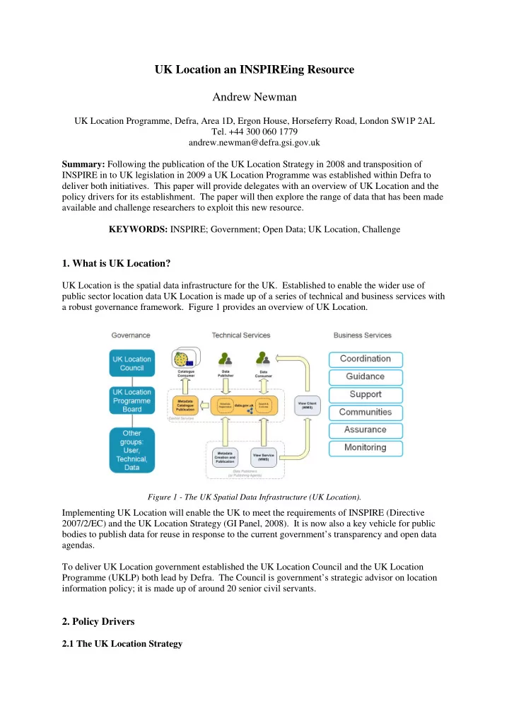
UK Location is the spatial data infrastructure for the UK. Established to enable the wider use of public sector location data UK Location is made up of a series of technical and business services with a robust governance framework. Figure 1 provides an overview of UK Location. Figure 1 - The UK Spatial Data Infrastructure (UK Location). Implementing UK Location will enable the UK to meet the requirements of INSPIRE (Directive 2007/2/EC) and the UK Location Strategy (GI Panel, 2008). It is now also a key vehicle for public bodies to publish data for reuse in response to the current government’s transparency and open data agendas. To deliver UK Location government established the UK Location Council and the UK Location Programme (UKLP) both lead by Defra. The Council is government’s strategic advisor on location information policy; it is made up of around 20 senior civil servants. 2. Policy Drivers 2.1 The UK Location Strategy

  2. The strategy was published in 2008 in response to a challenge from government to make better use of location data. It recognises the value of location data to the public sector and wider economy and sets out 5 strategic objectives to make more effective use of location data public sector. Figure 2 sets out these objectives and progress to date. Figure 2- Progress in delivering the UK Location Strategy 2.2 INSPIRE The EU INSPIRE Directive was introduced in 2007 and transposed into UK legislation in 2009 (SI 2009 No 3157 & SSI 2009 No 440). INSPIRE’s principal aim is to improve environmental policy making in Europe. Implementing the Directive will also enable better delivery and monitoring of public services and improve access to public sector information. Under INSPIRE member states must make spatial datasets available in a consistent formats and create services for accessing these datasets. INSPIRE specifies deadlines for delivering conformant data and services. The UK is making good progress in delivering INSPIRE. 2.3 The Right to Data “From July 2010, government departments and agencies should ensure that any information published includes the underlying data in an open standardised format.” Prime Minister, David Cameron When elected in 2010 the coalition government committed to being the most open government ever. The Coalition Agreement included a transparency agenda with a commitment to publish public data in reusable forms to enable economic growth and government accountability. Subsequently there have been a number of key developments: • Establishment a Transparency Board to lead on transparency including opening up public data. • Delivery of a public data portal (data.gov.uk). • Publication of large quantities of public sector information including spend and pay data. • Development of a series of Public Data Principles.

  3. • Development of the Open Government Licence. • Movement of OS, Met Office and Land registry to BIS with a view to establishing a Public Data Corporation (PDC). • Consultations on Open Data and the PDC. • Establishment of a single government agreement for access to OS data. • OS OpenData providing free access for all to a number of key OS datasets. • The announcement of a Public Data Group and governing Data Sharing Board in the chancellors Autumn Statement 2011. In light of the changing policy landscape Council reviewed its role and the Location Strategy in 2011 and concluded that it continues to be relevant and compelling. The Transparency Board has acknowledged the role Council can play and the importance of UK Location and INSPIRE. 3. The Data UK Location provides a rich catalogue of public sector location data, from a wide variety of public bodies. The data is discoverable at data.gov.uk, which provides textual search, map search and preview tools as well as catalogue services developers can integrate into applications. Delivering UK Location with data.gov.uk supports the government’s policy of a single point of access to public data. The INSPIRE Directive requires the publication of data for 34 themes (figure 3) covering a broad range of environmental data. The UK has published over 230 datasets for the INSPIRE Annex I & II themes. Figure 4 illustrates the quantity of data published at 9 November 2011, the deadline for INSPIRE Annex I & II datasets to be made discoverable with view services. Figure 5 shows the key organisations this data is sourced from. Figure 3- INSPIRE Data Themes & Deadlines

  4. Figure 4- Number of datasets & services available at 9/11/11 INSPIRE Deadline and 2013 Forecast Figure 5- Current UK Location data providers While the focus has been on the publication of data for INSPIRE UKLP is also working to facilitate the publication of a broader range of location data, this is illustrated by figure 4 which shows that at over 750 datasets not mandated by INSPIRE have also been published. UKLP is also investigating the publication of location data for health and infrastructure and it is considering its links with other initiatives including GMES, GEO and EOF. To register data to UK Location providers must also provide web services to enable users to easily consume the data. View services (WMS) allow users to draw snapshots of data into their applications, whilst download services (WFS) enable users to undertake more complex analysis and data processing. UK Location is adopting INSPIRE specifications for these services for all data. 4. Opportunities The delivery of UK Location presents users of location data with new opportunities. It is expected that implementing UK Location will deliver a range of benefits summarised, with examples, in Table 1.

  5. Delivering more for less • Reducing costs of delivery while providing Newport City Council has improved the services it provides to its citizen by implementing a single more value • addressing service across its business systems. Cutting duplication and promoting reuse The service uses the authorities Local Land and Property Gazetteer (LLPG) which is produced and maintained to national standards. Updating the central service instead of 17 separate systems has yielded an estimated annual net benefit of approximately £57,000 per annum. Better services • The East Sussex Partnership, which includes More effective and responsive public local authorities and police, has a shared web GIS services • based fault reporting service for citizens. This Better cross organisational coordination shared service has enabled: • More cost effective contact and feedback from citizen • A reduction in service costs, with 18,800 fault incidents logged over 5 years with an approximate net saving of £60,000 • Reduced remedial action costs Enabling innovative new services and economic growth • Natural England has a requirement to monitor Providing services which have been impractical or not cost effective moorland burning to ensure upland habitats are • being properly managed. Natural England and the Unanticipated reuse - new knowledge from British National Space Centre sponsored research different combination of data / data sets • to investigate if burns could be successfully Increased commercial innovation and monitored using earth observation, remote exploitation of location data • sensing, automated image classification and GIS. Improved capacity and capability for use of The pilot projects were successful and the location data methodology is being used on a site by site basis leading to a reduction in field work and reduced costs. Better informed policy development and decision making • In anticipation of possible flu pandemics the Providing an improved evidence base • NHS established a network of local collection Better preparation for and response to points for antiviral drugs. emergencies An analysis of potential sites using data on public buildings, accessibility, security and other factors such as homelessness and vulnerable people was undertaken. Data was sourced from multiple organisations and integrated and analysed in GIS reducing the time required to develop the network to 3 days. More open government

Download Presentation
Download Policy: The content available on the website is offered to you 'AS IS' for your personal information and use only. It cannot be commercialized, licensed, or distributed on other websites without prior consent from the author. To download a presentation, simply click this link. If you encounter any difficulties during the download process, it's possible that the publisher has removed the file from their server.

Recommend


More recommend