
SLIDE 1
Todays Agenda Sources of Water on Earth Montgomery County - - PowerPoint PPT Presentation
Todays Agenda Sources of Water on Earth Montgomery County background What is a Watershed & Runoff? Intro to Stormwater What the County is Doing to Protect Our Streams Project Locations Proposed Preliminary Upgrade
Sources of Water on Earth Montgomery County background What is a Watershed & Runoff? Intro to Stormwater What the County is Doing to Protect Our Streams Project Locations Proposed Preliminary Upgrade of the Pond Mosquitos Questions/Comments
2
About 97% is salt water About 2% is freshwater Only 1% is available for drinking water
95% from groundwater across the Country 32% from groundwater, 68% from surface water in Maryland
Potential for greater impacts from runoff in Maryland
3
500 sq. miles Over 1 Million people
Second only to Baltimore City within
Maryland in average people per square mile
184 languages spoken
About 12% impervious surface overall
About the size of Washington DC
Over 1,500 miles of streams Two major river basins:
Potomac Patuxent
Eight local watersheds
Your Watershed is: Muddy Branch
4
District of Columbia
Impervious: Not allowing water to soak through the ground.
Chesapeake Bay Eight local watersheds Neighborhood (to a storm
drain)
5
Image from City of Oxford, NC
6
7
Must meet regulatory requirements
Federal Clean Water Act permit program MS4 = Municipal Separate Storm Sewer System
Applies to all large and medium Maryland jurisdictions County programs
Restore our streams and watersheds
Add runoff management
Meet water quality protection goals
Reduce pollutants getting into our streams
Educate and engage all stakeholders
Individual actions make a difference
Focus on watersheds showing greatest impacts
Requires additional stormwater management for 20
percent of impervious surfaces (3,777 acres).
8
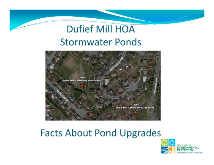
Kings Grant St. – Asset #10904
The area outlined in dark black all drains into this pond.
Drainage Area = 22 acres
Impervious Surfaces = 6 acres (Rooftops, driveways, roads, etc.)
Pond
9
Lake Winds Way – Asset #11094
The area outlined in dark black all drains into this pond.
Drainage Area = 46 acres
Impervious Surfaces = 12 acres (Rooftops, driveways, roads, etc.)
Pond
10
Channel Protection Volume (CPV)
Designing a pond to capture 2.6 inches of rain (a 1‐year storm event) Storing and slowly releasing this rain event for 12 to 24 hours Main Objective for this Design: Provide the greatest impact to reduce
downstream erosion
Water Quality Volume (WQV)
Capturing and filtering out the pollutants during a 1 inch rain event, and
is based on impervious area
Main Objective for this Design: Reduce nutrients from entering the
stream
Ideal Situation
Design a facility that does both with the land area being the only
limiting factor
11
12
13
In Construction 1 Year After Construction Example: 5 Years After Construction Example: 5 Years After Construction 14
Frogs
115
Maximize pond area because it is harder to find
DEP understands the impacts to the community must
be considered in choosing retrofit options
DEP will take HOA boards thoughts and concerns into
great consideration.
Balance the impacts to the community, level of
stormwater control, and environmental disturbance.
DEP wants the facility to be an amenity to the community.
DEP is seeking to move forward from preliminary
assessment of the facility to a concept design where the feasibility of the project can be determined.
16
Dufief Mill
17