The Project: Transforming the Chelsea railway corridor into a - - PowerPoint PPT Presentation
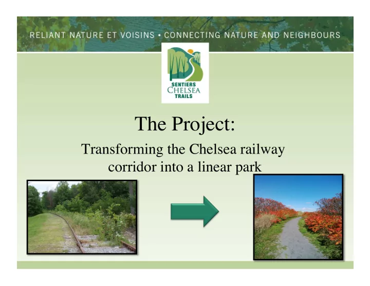
The Project: Transforming the Chelsea railway corridor into a linear park Sentiers Chelsea Trails SCT is a community based, not-for-profit group dedicated to the preservation and creation of a green trail network linking the village centre,
Sentiers Chelsea Trails
SCT is a community based, not-for-profit group dedicated to the preservation and creation of a green trail network linking the village centre, schools and community centres to neighbourhoods and to the natural assets of Gatineau Park and the Gatineau River.
Our vision of the project
- Create a linear park consisting of
a multipurpose trail, from Loretta Loop to Morrison quarry
- A non-motorized green corridor
- Four-season trail: skiing, jogging,
snowshoeing, sledding in winter; walking, cycling and other forms
- f active transport in other
seasons
Project objectives
- Promote accessibility and active transportation for
all Chelsea residents
- Respect privacy of residents living along the
corridor
- Respect the environment during transformation
- Ensure the park is a dog friendly zone
Project numbers
- Total length from Loretta Loop to Morrison
quarry = 19.9 km
- Length of corridor along the river = 7 km (35%)
- Average width of corridor = 21 m (66 ft.)
- Average width at Mill Road, Kirk’s Ferry, Burnet
and other intersections= 45 m (double tracks, former train stations)
Implementation of Active Transport Master Plan
PDTA: 3.3 Sentiers polyvalents en site propre
Grands axes structurants (AS) Axe structurant AS 1 – Corridor du chemin de fer Hull — Wakefield Description du corridor : L’axe nord-sud du chemin de fer entre Gatineau et Wakefield constitue un lien idéal pour les modes actifs. Situé en bordure de la rivière Gatineau, il offre un paysage hors pair, généralement éloigné de la circulation routière et traverse très peu d’intersection. Sa convivialité et sa sécurité en font un lien favorable aux déplacements récréatifs, mais son efficacité le rend également attrayant aux déplacements utilitaires. ♣ Zonage : Public – appartiens à la municipalité. Ancien corridor de la compagnie de chemin de fer de l’Outaouais (page 13)
Building on a successful experience
- Building on the success of 10 years
- f experience
- Non-motorized winter trail on
railway corridor (14.7 km) since 2005
- Community collaboration with
municipality, Sentiers Chelsea Trails, residents and businesses
- Corridor serving the community
Creating community partnerships
- Gatineau Valley Historical Society
- Cascades Club
- Larrimac Golf Club
- ACRE
- Commerce Chelsea
- GRYC
- Transcanada Trail
- Neighbourhood Watch
- Elementary schools
Challenges
- Approvals from MTQ and MDDELCCP for
first phase
- Responding to residents’ concerns − noise,
potentiel intrusions, traffic
- Fundraising
- 2nd phase: installing control barriers,
security, garbage, parking
Responding to community concerns
- Promote an inclusive approach to consult widely
- Prioritize privacy of residents living along the
corridor
- Focus design on security of all users
- Ensure linkages with secondary trails as indicated
in the ATMP
Our ask to the municipality
That municipal council adopt a resolution recognizing the merits of the project for the community and mandating a joint working group to manage the project composed of municipal and Chelsea Trails representatives
Tentative calendar for creation of Gatineau River linear park
Spring, fall 2015
Planning and implementing linear park project Consulting residents
Fall 2016
Construction of linear park
Spring 2017
Official opening of park