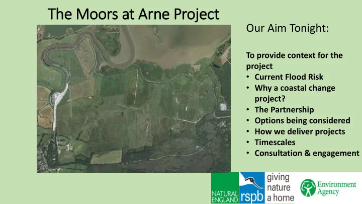
SLIDE 1 The Moors at Arne Project
Our Aim Tonight:
To provide context for the project
- Current Flood Risk
- Why a coastal change
project?
- The Partnership
- Options being considered
- How we deliver projects
- Timescales
- Consultation & engagement
SLIDE 2
The Moors at Arne Project
Site Area: Red = RSPB Blue = Natural England Yellow = Arne Road
SLIDE 3
The Moors at Arne Project
Site Area: Red = RSPB Blue = Natural England Yellow = Arne Road
SLIDE 4
Current Flood Risk
Historic Tidebanks Draining the land for agriculture & Securing Navigation
SLIDE 5
Current Flood Risk
Historic Tidebanks Draining the land for agriculture & Securing Navigation
SLIDE 6 Current Flood Risk
Historic Tidebanks Draining the land for agriculture & Securing Navigation
1911 – Clay barges returning to Wareham from Poole Quay
SLIDE 7
Current Flood Risk
Historic Tidebanks Draining the land for agriculture & Securing Navigation reforming in 1957
SLIDE 8
The Current Flood Risk – Stoborough & Ridge
https://flood-warning-information.service.gov.uk/long-term-flood-risk/map
SLIDE 9
The Current Flood Risk – Stoborough & Ridge
https://flood-warning-information.service.gov.uk/long-term-flood-risk/map
SLIDE 10 The Current Flood Risk – Stoborough
NTL
SLIDE 11
The Current Flood Risk – Redcliffe to Ridge
SLIDE 12 River Frome occupies the floodplain near Stoborough
Stoborough Ridge The Moors
SLIDE 13
The Current Surface Water Risk – Stoborough & Ridge
https://flood-warning-information.service.gov.uk/long-term-flood-risk/map
SLIDE 14
The Current Surface Water Risk – Stoborough & Ridge
https://flood-warning-information.service.gov.uk/long-term-flood-risk/map
SLIDE 15
The Climate Change Prediction
SLIDE 16 Wareham Coastal Change
National Policy – National Strategy – Plans – Local Strategies - Schemes
Bestwall bank reinstatement 2015
SLIDE 17
Why a Coastal Change Proje ject? Context xt wit ithin in Poole Harbour
SLIDE 18 What is ‘Coastal Squeeze’?
National Policy – National Strategy – Plans – Local Strategies - Schemes
SLIDE 19 Poole Quay Tidal Defence Improvements
National Policy – National Strategy – Plans – Local Strategies - Schemes
SLIDE 20 Poole & Wareham Flood & Coastal Risk Management Str trategy
- Adopted March 2015
- Increased flood & erosion risk
(700mm SLR by 2100), leading to:
- Over 10,000 properties at risk by 2100.
- Present Value of benefits £1.75 billion
- Developed Areas justify Hold The Line Policy.
- Requirement for Compensatory habitat.
IROPI case approved.
- Intertidal Habitat Loss Predictions
(cumulative) Epoch 1 - 2030 – 44ha Epoch 2 - 2060 – 87ha Epoch 3 - 2110 – 313ha
SLIDE 21 Habitat Creation Objectives
- Working with Natural Processes
- Developing a mosaic of Intertidal habitats across the site including:
Saltmash Mudflat Saline Lagoons
- Protecting rare and irreplaceable habitats in situ – Cladium Fen
SLIDE 22 Strategic Context – Compensatory ry Habitat
Strategic Challenge
- Finding suitable sites
- Area Heavily Designated,
reflecting the special character of Poole Harbour
Options – three sites
Lytchett Bay – French’s Farm Keysworth Arne Moors
SLIDE 23 Our Preferred Site - Moors at Arne
- Partnership Project.
- Existing landowners – RSPB & NE.
- Developed a collaborative agreement.
- Secured funding for Detailed Design.
- Awarded a design contract to CH2M.
SLIDE 24 Doin ing nothing at Arn rne is is not an option
Turners Cove Sluice 2015
SLIDE 25
Our Shared Vis ision – Conceptual Layout
SLIDE 26 Desig ign Phil ilosophy
- Developing a cost effective scheme – meets all the partners objectives.
- Restoring and working with natural process.
- Maximising the potential of the site – future proofing – lagoons.
- Providing on site mitigation for SPA and Ramsar features.
- Developing the site in a way that benefits people and wildlife – controlled access.
Developing the Scheme
- Consultants team CH2M, ABPmer & APEM
- Use of National & local experts via Technical Advisory Group (TAG)
- Habitats Regulation Assessments – on site mitigation
- Preliminary Ecological Appraisal
- Cultural Heritage
- Consultation with Parish Council, local residents and the general
public
SLIDE 27 Min inimum Desig ign Components
As a minimum any scheme will provide the following:
- Maintaining flood risk resilience to people, property and infrastructure.
- Sufficient surface capacity to maintain existing levels of land drainage.
- 44ha of open Intertidal habitat with at least one breach.
- Saline lagoons.
- New embankments at the rear of the site to protect the existing SAC features.
- New freshwater habitat with a ditch network behind the new defences to
mitigate for the loss of the existing freshwater features.
- On site mitigation for protected species.
SLIDE 28
Short Lis isted Options (1 (1a) - Modelling
SLIDE 29
Short Lis isted Options (1 (1b) - Modelling
SLIDE 30
Short Lis ist Options (1 (1c) ) - Modelling
SLIDE 31 Fit it wit ith Wid ider In Init itiatives
Wareham Tide Banks
Bestwall 2015 Redcliffe
Turners Cove Wareham Royalty Moorings Navigation
SLIDE 32 Outline Programme - Draft ft
June 2017 – Short list options March 2018 - Preferred Option Oct 2017 - Public Exhibition Winter 2018 - Public Consultation Summer 2019 – Planning application 2020 - Commence Construction Sept 2017 - Statutory Consultees Meeting
SLIDE 33 Consultation & Engagement
- Email:
- Website:
- Clinics:
- Arne Parish Council
- Stakeholder meetings:
- Public Consultation:
- Single point of contact: