
SLIDE 1
States, Greenland, the British Isles, Scandinavia and Africa Rock - - PowerPoint PPT Presentation
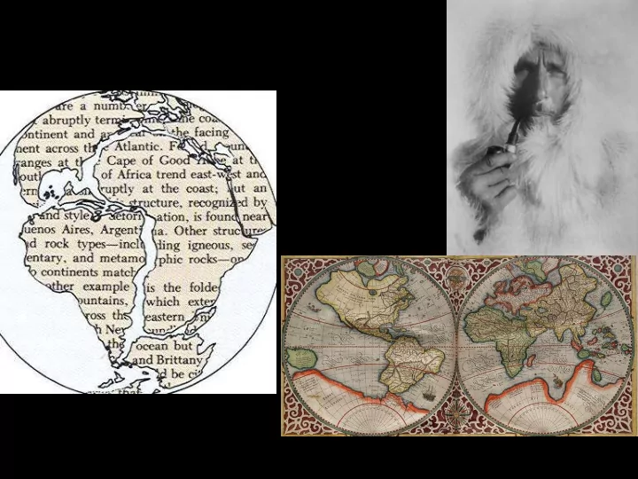
Mountain belts across the United States, Greenland, the British Isles, Scandinavia and Africa Rock similarities between Africa and South America 160 myo Iceland India is still colliding with Asia 450 mi Much less pressure and heat,
Rock similarities between Africa and South America Mountain belts across the United States, Greenland, the British Isles, Scandinavia and Africa
160 myo
Iceland
India is still colliding with Asia
High pressure and heat, dense material-solid
Less pressure high heat, dense material, liquid Less pressure and heat, but less dense material, so solid
Much less pressure and heat, light material, liquid
1800 mi 1400 mi 750 mi 450 mi
=slippage =point above focus
2010—Haiti—200,000 (?) dead; magnitude=7.0 1989—San Francisco—62 dead, damages of $6 billion; magnitude=7.1 1994—Los Angeles—51 dead, damages of 15 billion; magnitude=less than 6.9 1906—San Francisco—1500 dead; magnitude=8.2 1960—Chile—5700 dead; magnitude=9.5 (highest) 1811—St. Louis—dead ?; magnitude=8.0? 1886—Charleston—60 dead; magnitude=7.3? 1976—China—240,000 dead; magnitude=7.6 1556—China—830,000 dead; magnitude=? 2004—Southeast Asia—0; magnitude=9.1 2005—Southeast Asia—1000+, magnitude=8.7
Displacement can create a huge seismic wave called a tsunami
Close to epicenter Initial wave (front)
(20 min)
Wave (back) from other side of Earth (1.5 hrs)
Initial wave returns
(2 hrs)
Epicenter
Magnitude 6.0 Date-Time Tuesday, September 28, 2004 at 17:15:24 (UTC) - Coordinated Universal Time Tuesday, September 28, 2004 at 10:15:24 AM local time at epicenter Time of Earthquake in other Time Zones Location 35.81N 120.37W Depth 8 kilometers Region CENTRAL CALIFORNIA Reference 30 km (20 miles) SW of Avenal, California 35 km (20 miles) S of Coalinga, California 35 km (25 miles) ENE of Paso Robles, California 325 km (200 miles) SSE of SACRAMENTO, California Remarks Minor damage (VI) at Parkfield and San Miguel. Felt (V) at Avenal, Bradley, Coalinga, Paso Robles, Shandon and Templeton. Felt throughout central California from Sacramento and San Francisco south as far as Los Angeles and Orange County.
Hanging wall Footwall
Normal faulting
Glacier National Park
Reverse faulting
Vertical and horizontal
Fold Faults
Stress Folding Intense folding Faulting
Dome Basin
600 400 200 55 2
Dome
2 55 200 400 600
Basin
Large magma chamber
Without support, crater collapses
Small cinder cone forms
Blocks Bombs