
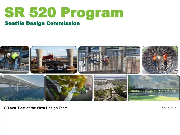
SLIDE 1
SR 520 Pr SR 520 Prog
- gram
am
June 2, 2016
Sea eattle D ttle Design esign Commi Commissi ssion
- n
SR 520 Rest of the West Design Team
SR 520 Pr SR 520 Prog ogram am Sea eattle D ttle Design esign - - PowerPoint PPT Presentation
SR 520 Pr SR 520 Prog ogram am Sea eattle D ttle Design esign Commi Commissi ssion on SR 520 Rest of the West Design Team June 2, 2016 Design Presentation Overview Today, seeking endorsement of: Program Overview Refined Montlake
June 2, 2016
Sea eattle D ttle Design esign Commi Commissi ssion
SR 520 Rest of the West Design Team
Program Overview
Design Presentation
Today, seeking endorsement of:
programming
2
Safety and Mobility Improvements
FUNDED
The SR 520 Bridge Replacement and HOV Program is a $4.56 billion investment in the regional transportation system. The program is enhancing a vital connection from Seattle to the Eastside via Lake Washington, resulting in major improvements for drivers, transit riders, bicyclists and pedestrians.
Replacing vulnerable structures Enhancing mobility
The SR 520 program is improving safety by:
currently at risk of failure
The SR 520 program is enhancing mobility by:
carpool trip reliability
path
ramps along the corridor
3
Program schedule
Program map
FUNDED
4
Under Construction: West Approach Bridge North Montlake lid/land bridge West Approach Bridge South Portage Bay Bridge 10th and Delmar lid I-5 interchange Montlake Cut crossing
Next phas xt phase
Possible future use of a portion of NOAA property, approximating the area shown in the FEIS, for public pedestrian-bike path is subject to agreement by NOAA as a part of
5
Continuity
vision
Approach Bridge
Distinction
Interchange
Contract procurement
Mar./Apr. May/June July-Late 2016
Ongoing SDC coordination
2017 and beyond
Jan./Feb.
6
WSDOT Objectives
Seattle, and other stakeholders including King County Metro, University of Washington, Section 106 Concurring Parties
future construction contracts
City Objectives
31611
7
Our vision for the SR 520 corridor is to become a sequence of gateways for the City of Seattle by reconnecting to the Seattle vision
We intend to implement our Program in a manner that yields practical solutions and fosters sustainability practices that support regional and local connectivity, ecology and the use of low-carbon
functionality, proportion and sense of speed along the SR 520 facility to provide a memorable experience for all users.
8
Su Sustain stainabil ility ity
Co Commu mmunit ity En Envi vironmen mental l St Stewardship ship
Restoration GHG
Modal Integration Technology St Strategic ic In Invest stmen ment
Practical Design
9
Community Aesthetic Design Consultant Column folly User experience along pathways* Gateway design – unique multimodal experience Viewpoint opportunities* Lid character and program* Process delivery overview
* Items we’re discussing today Items we continue to discuss with the SDC subgroup
10
Improves regional and neighborhood non-motorized connections Enhances transit experience and vehicular functionality Creates a practical solution to multiple needs Restores and improves ecological systems and connectivity Improves air quality and reduces noise Produces safe and functional space for neighborhood and regional use Brings human scale and community character to create distinctive spaces Forms a memorable and layered gateway experience
11
Concepts and materials shown may be further refined pending outcomes of ongoing maintenance conversations between WSDOT, the City of Seattle, and King County Metro.
12
Pre-1851: Duwamish, and
and byways. Local place name “Carry a Canoe” indicates passage between the waterways.
Transportation Landscape
Connectivity
Concepts and materials shown may be further refined pending outcomes of ongoing maintenance conversations between WSDOT, the City of Seattle, and King County Metro.
13
Concepts and materials shown may be further refined pending outcomes of ongoing maintenance conversations between WSDOT, the City of Seattle, and King County Metro. Courtesy Paul Dorpat.
14
1851: European American settlers arrive. 1869: Seattle incorporated. 1876: Land for Volunteer Park & Lakeview Cemetary set aside. 1860s-1880s: Montlake Ditch constructed to aid logging transport between waterways.
Transportation Landscape
Connectivity
Concepts and materials shown may be further refined pending outcomes of ongoing maintenance conversations between WSDOT, the City of Seattle, and King County Metro.
15
Courtesy MOHAI, Seattle Concepts and materials shown may be further refined pending outcomes of ongoing maintenance conversations between WSDOT, the City of Seattle, and King County Metro.
16
Courtesy UW Special Collections.
1898: Canal Reserve established around Montlake Ditch. 1907: Olmstead Brothers propse Lake Washington Boulevard extension. to Alaska- Yukon Exhibition at UW site. 1909-1916: Dredging of Montlake Cut. Lake Washington water level lowered by 9 feet.
Transportation Landscape
Connectivity
Concepts and materials shown may be further refined pending outcomes of ongoing maintenance conversations between WSDOT, the City of Seattle, and King County Metro.
17
Courtesy MOHAI, Seattle Concepts and materials shown may be further refined pending outcomes of ongoing maintenance conversations between WSDOT, the City of Seattle, and King County Metro.
18
1925: Montlake Bridge opens. 1934-1935: UW Arboretum established Washington Park site. Olmstead Brothers submit plans. 1935-1941: Arboretum lands graded & planted, major structures constructed (including canal reserve).
Transportation Landscape
Connectivity
Concepts and materials shown may be further refined pending outcomes of ongoing maintenance conversations between WSDOT, the City of Seattle, and King County Metro.
19
Concepts and materials shown may be further refined pending outcomes of ongoing maintenance conversations between WSDOT, the City of Seattle, and King County Metro.
20
Courtesy MOHAI, Seattle Concepts and materials shown may be further refined pending outcomes of ongoing maintenance conversations between WSDOT, the City of Seattle, and King County Metro.
21
1941: WPA assistance to Arboretum discontinued. 1940s-1950s: development
continues. 1952: MOHAI opens, primary access from south via Lake Washington Boulevard.
Transportation Landscape
Connectivity
Concepts and materials shown may be further refined pending outcomes of ongoing maintenance conversations between WSDOT, the City of Seattle, and King County Metro.
22
Concepts and materials shown may be further refined pending outcomes of ongoing maintenance conversations between WSDOT, the City of Seattle, and King County Metro.
23
1961-1963: Construction
R.H.Thompson expresway proposed, cutting through arboretum. 1968: Waterfront / Foster Island trail constructed. 1969-1972: Freeway protests. Thompson Expressway plan rejected by voters.
Transportation Landscape
Connectivity
Concepts and materials shown may be further refined pending outcomes of ongoing maintenance conversations between WSDOT, the City of Seattle, and King County Metro.
24
Concepts and materials shown may be further refined pending outcomes of ongoing maintenance conversations between WSDOT, the City of Seattle, and King County Metro.
25
Concepts and materials shown may be further refined pending outcomes of ongoing maintenance conversations between WSDOT, the City of Seattle, and King County Metro.
26
1972-2014: “Ramps to Nowhere” 2000-2010s: SR520 improvements
Transportation Landscape
Connectivity
Concepts and materials shown may be further refined pending outcomes of ongoing maintenance conversations between WSDOT, the City of Seattle, and King County Metro.
27
Concepts and materials shown may be further refined pending outcomes of ongoing maintenance conversations between WSDOT, the City of Seattle, and King County Metro.
28
SR520 improvements complete
Transportation Landscape
Connectivity
Concepts and materials shown may be further refined pending outcomes of ongoing maintenance conversations between WSDOT, the City of Seattle, and King County Metro.
29
Concepts and materials shown may be further refined pending outcomes of ongoing maintenance conversations between WSDOT, the City of Seattle, and King County Metro.
30
Traffic Volumes and Transit Routes
Montlake Boulevard – 57,400 Average Daily Traffic (2014) Lake Washington Boulevard – 15,600 Average Daily Traffic (2014) SR 520 - 80,000 Average Daily Traffic East-West Transit: Routes 167, 242, 252/257, 255, 271, 277, 296, 311, 540, 542, 556, 545, 555 North – South Transit: Route 43, 48
Concepts and materials shown may be further refined pending outcomes of ongoing maintenance conversations between WSDOT, the City of Seattle, and King County Metro.
31
We seek to create a new Civic Infrastructure that integrates future-compatible transportation needs, restores the local ecology, neighborhood and greenway connections, and draws on the significance of the place. 32
Comprehensive Approach: Connect Multiple Smaller spaces to form larger network Unified Composition Borrowed landscape Genius of Place Embracing the uniqueness of site Orchestration of Use and Movement Clear and varied
Concepts and materials shown may be further refined pending outcomes of ongoing maintenance conversations between WSDOT, the City of Seattle, and King County Metro.
33
Progression of Experience
CITY
NEIGHBORHOODConcepts and materials shown may be further refined pending outcomes of ongoing maintenance conversations between WSDOT, the City of Seattle, and King County Metro.
34
NATURE
SHORELINE / ARBORETUM / OLD CANAL RESERVENATURE MEETS CITY
SR 520 PROJECT & VICINITYCITY
NEIGHBORHOODNATURE
SHORELINE / PARK LANDSEast Montlake Park Union Bay National Oceanic and Atmospheric Administration Montlake Playfield Arboretum
Possible future use of a portion of the NOAA property, approximating the area shown in the FEIS for a public pedestrian-bike path is subject to agreement by NOAA as a part of ongoing mitigation discussion Concepts and materials shown may be further refined pending outcomes of ongoing maintenance conversations between WSDOT, the City of Seattle, and King County Metro.
35
Concepts and materials shown may be further refined pending outcomes of ongoing maintenance conversations between WSDOT, the City of Seattle, and King County Metro.
36
Concepts and materials shown may be further refined pending outcomes of ongoing maintenance conversations between WSDOT, the City of Seattle, and King County Metro.
37
Concepts and materials shown may be further refined pending outcomes of ongoing maintenance conversations between WSDOT, the City of Seattle, and King County Metro.
38
Concepts and materials shown may be further refined pending outcomes of ongoing maintenance conversations between WSDOT, the City of Seattle, and King County Metro.
39
Concepts and materials shown may be further refined pending outcomes of ongoing maintenance conversations between WSDOT, the City of Seattle, and King County Metro.
40
Concepts and materials shown may be further refined pending outcomes of ongoing maintenance conversations between WSDOT, the City of Seattle, and King County Metro.
41
Concepts and materials shown may be further refined pending outcomes of ongoing maintenance conversations between WSDOT, the City of Seattle, and King County Metro.
42
Gateway Experience Looking East
NOTE: For clarity renderings do not show all utilities, transit infra- structure and signage. Concepts and materials shown may be further refined pending outcomes of ongoing maintenance conversations between WSDOT, the City of Seattle, and King County Metro.
43
View Looking West at Land Bridge
NOTE: For clarity renderings do not show all utilities, transit infra- structure and signage. Concepts and materials shown may be further refined pending outcomes of ongoing maintenance conversations between WSDOT, the City of Seattle, and King County Metro.
44
View Along Regional Shared Use Path
NOTE: For clarity renderings do not show all utilities, transit infra- structure and signage. Concepts and materials shown may be further refined pending outcomes of ongoing maintenance conversations between WSDOT, the City of Seattle, and King County Metro.
45
View from Portage Bay Looking East
NOTE: For clarity renderings do not show all utilities, transit infra- structure and signage. Concepts and materials shown may be further refined pending outcomes of ongoing maintenance conversations between WSDOT, the City of Seattle, and King County Metro.
46
Casual Strollers Special Event Neighborhood Families Weekend Warrior Bicyclist Transit User
Neighborhood City
Concepts and materials shown may be further refined pending outcomes of ongoing maintenance conversations between WSDOT, the City of Seattle, and King County Metro.
47
Forward Compatibility
Concepts and materials shown may be further refined pending outcomes of ongoing maintenance conversations between WSDOT, the City of Seattle, and King County Metro.
48
Forward Compatibility
Concepts and materials shown may be further refined pending outcomes of ongoing maintenance conversations between WSDOT, the City of Seattle, and King County Metro.
49
COMMUNITY DINNER SMALL CONCERT/BUSKER YOGA COMMUNITY MARKET/VENDORS
Concepts and materials shown may be further refined pending outcomes of ongoing maintenance conversations between WSDOT, the City of Seattle, and King County Metro.
50
GAME DAY / OPENING DAY TRANSIT SUNBATHING / PICNIC / URBAN LOUNGE
Forward Compatibility
RACE DAY
CULTURAL: hand-crafted texture adzed patterns elements, refined Pacific NW crafts, craftsman CULTURAL: oars mark- er pole shapes, pattern element RECENT-HEROIC: ur- ban erratics cut pieces of the hollow columns and 520 structure GEOLOGIC HISTORY/ REMNANTS: erratics and other stone elements
RECENT-HEROIC: ur- ban erratics 520 structure repurposed concrete CULTURAL: urban erratics Montlake neighborhood history - stair/ porch detail recalled on site, other small residential architec- tural “details” Interpretive Signage Complementary to Arbore- tum system
Concepts and materials shown may be further refined pending outcomes of ongoing maintenance conversations between WSDOT, the City of Seattle, and King County Metro.
51
System Map/In- terpretive Signs Urban Erratics: Cultural History Lake Washing- ton Boulevard Stone transition features Site Wall Repurposed concrete from 520 demo Site Wall Repurposed concrete from 520 demo
Concepts and materials shown may be further refined pending outcomes of ongoing maintenance conversations between WSDOT, the City of Seattle, and King County Metro.
52
Progression of Experience
Concepts and materials shown may be further refined pending outcomes of ongoing maintenance conversations between WSDOT, the City of Seattle, and King County Metro.
53
Place for Picnics Outlooks Dog Walking Places to Sit Nature Viewing Focal Point Meeting Spot Walking Trails Vendors Place to Stretch Secure Bike Parking Bicycling Trails Running Trails Bird Watching Bike Repair Stand
Possible Activities
Covered Waiting Areas Secure Bike Storage
Concepts and materials shown may be further refined pending outcomes of ongoing maintenance conversations between WSDOT, the City of Seattle, and King County Metro.
54
Concepts and materials shown may be further refined pending outcomes of ongoing maintenance conversations between WSDOT, the City of Seattle, and King County Metro.
55 Lives or works near the
socialize with neighbors, and a place to walk the dog.
benches along informal path
trails for dog walking nature viewing
Concepts and materials shown may be further refined pending outcomes of ongoing maintenance conversations between WSDOT, the City of Seattle, and King County Metro.
56
Looking West near 24th Street
existing 2x2 sidewalk gravel pathway with concrete edging Olmsted legacy domus fixture moss inducing textured concrete
Casual Stroller
6’ Existing Sidewalk 8’ Path
EB SR 520
paving lighting planting paving site walls
Concepts and materials shown may be further refined pending outcomes of ongoing maintenance conversations between WSDOT, the City of Seattle, and King County Metro.
58
6’ Exidting Sidewalk 8’ Path Lid Structure
p p P
Looking West at open space
existing 2x2 sidewalk gravel pathway with concrete edging Olmsted legacy domus fixture World’s Fair bench
Concepts and materials shown may be further refined pending outcomes of ongoing maintenance conversations between WSDOT, the City of Seattle, and King County Metro.
58
Casual Stroller
paving lighting planting
WB SR 520 On-ramp
paving
WB SR 520
site walls
SE Corner of Lake Washington Blvd Intersection
large specimen tree continue sidewalk pattern across intersection referential stone gateway ele- ment gateway stone element specimen tree lawn
Casual Stroller
Concepts and materials shown may be further refined pending outcomes of ongoing maintenance conversations between WSDOT, the City of Seattle, and King County Metro.
59
16’ Path Montlake Boulevard East EB SR 5 2 0
Looking north at main open space
site walls
Olmsted legacy 2x2 scored concrete
plaza lighting street lighting plaza paving
horizontal scored concrete
street edge planting sidewalk paving
undermount in site walls along plaza
per city precedent
adze texture concrete
Concepts and materials shown may be further refined pending outcomes of ongoing maintenance conversations between WSDOT, the City of Seattle, and King County Metro.
60
City street light
Casual Stroller
10’ City Sidewalk
Looking at north west side of Montlake Blvd
site walls
Olmsted legacy 2x2 scored concrete
plaza lighting sidewalk paving plaza paving
horizontal scored concrete
street lighting street edge planting
undermount in site walls along plaza adze texture concrete
Concepts and materials shown may be further refined pending outcomes of ongoing maintenance conversations between WSDOT, the City of Seattle, and King County Metro.
61
City street light
Casual Stroller
at outlook Lid Edge
2x2 scored concrete
street edge planting lighting
Olmsted legacy
retaining wall
moss inducing textured concrete
sidewalk paving
horizontal tiled scoring
plaza has “urban” geometry, aligned for maximum view integrated seat wall lean rail
Casual Stroller
City street light
site wall
adze texture con- crete wall
Concepts and materials shown may be further refined pending outcomes of ongoing maintenance conversations between WSDOT, the City of Seattle, and King County Metro.
62
Looking west
Casual Stroller
Concepts and materials shown may be further refined pending outcomes of ongoing maintenance conversations between WSDOT, the City of Seattle, and King County Metro.
63
Concepts and materials shown may be further refined pending outcomes of ongoing maintenance conversations between WSDOT, the City of Seattle, and King County Metro.
64 Lives within walking
to learn, explore, and play.
plaza space for carts/vendors lawn area for sunbathing/ picnicking planted area walking/hiking trails
covered space to meet/gather
Concepts and materials shown may be further refined pending outcomes of ongoing maintenance conversations between WSDOT, the City of Seattle, and King County Metro.
65
World’s Fair bench integrated shelter lawn
Neighborhood Family
Olmsted legacy adze texture con- crete walls 24th Ave E Montlake Blvd E
Concepts and materials shown may be further refined pending outcomes of ongoing maintenance conversations between WSDOT, the City of Seattle, and King County Metro.
66
paving Olmsted legacy gravel edged with concrete furniture
desire line has clear landing location seat wall serves plaza and
protected seating area
lawn
Lake Washington Blvd paving Lake Washington Blvd seating central open space planting Lake Washington Blvd planting plaza paving
Neighborhood Family
Concepts and materials shown may be further refined pending outcomes of ongoing maintenance conversations between WSDOT, the City of Seattle, and King County Metro.
68
View looking East from Montlake Blvd
Neighborhood Family
Concepts and materials shown may be further refined pending outcomes of ongoing maintenance conversations between WSDOT, the City of Seattle, and King County Metro.
69
69
Concepts and materials shown may be further refined pending outcomes of ongoing maintenance conversations between WSDOT, the City of Seattle, and King County Metro.
Meets up with colleagues for an afternoon ride. Needs bike amenities, leg- ible network, shelter from rain.
RSUP
70
Concepts and materials shown may be further refined pending outcomes of ongoing maintenance conversations between WSDOT, the City of Seattle, and King County Metro.
Plaza space for carts/vendors Covered space to meet/gather Lawn area to stretch/relax decision point in wayfinding decision point in wayfinding Bicycle maintenance facilities integrated into transit shelters
Looking west
Bicyclist
planting
portage passage
RSUP paving
asphalt scored concrete
sidewalk paving RSUP lighting
bollard system
71
Concepts and materials shown may be further refined pending outcomes of ongoing maintenance conversations between WSDOT, the City of Seattle, and King County Metro.
RSUP and land bridge intersection
path intersection
scored horizontal concrete/pavers
land bridge paving
asphalt with gravel shoulder
RSUP paving
asphalt
planting
gravel patch - radius for trucks doubles as signage area concrete bands feather out to indicate key intersections
portage passage
meandering stairs to view point
Bicyclist
72
Concepts and materials shown may be further refined pending outcomes of ongoing maintenance conversations between WSDOT, the City of Seattle, and King County Metro.
Bicyclist
Olmsted bend and land bridge intersection
path intersection lighting planting paving site walls
scored horizontal concrete recycled concrete gravel pathway with concrete edging Olmsted legacy domus fixture
concrete bands feather out to indicate key intersections gravel space for sign seating area
73
Concepts and materials shown may be further refined pending outcomes of ongoing maintenance conversations between WSDOT, the City of Seattle, and King County Metro.
Bicyclist
NOTE: For clarity renderings do
74
Concepts and materials shown may be further refined not show all utilities, transit infra- pending outcomes of ongoing maintenance conversations structure and signage. between WSDOT, the City of Seattle, and King County Metro.
Olmsted bend and land bridge intersection
75
Concepts and materials shown may be further refined pending outcomes of ongoing maintenance conversations between WSDOT, the City of Seattle, and King County Metro.
Commutes using multiple
plaza everyday, has a ritual.
Transit Stop/Shelter HOV/Transit Direct Access Ramps Transit Stop/Shelter Bicycle Storage Lockers Plaza space for carts/vendors
76
Concepts and materials shown may be further refined pending outcomes of ongoing maintenance conversations between WSDOT, the City of Seattle, and King County Metro.
North-South Section: Plaza
Transit User
World’s Fair bench integrated shelter with bike program lawn textured site walls Olmsted Legacy
78
Concepts and materials shown may be further refined pending outcomes of ongoing maintenance conversations between WSDOT, the City of Seattle, and King County Metro.
Transit User
Concept
integrated shelter
79
Concepts and materials shown may be further refined pending outcomes of ongoing maintenance conversations between WSDOT, the City of Seattle, and King County Metro.
Steel only Condition Steel + Wood Condition
Photovoltaic Roof Steel Purlins Steel Columns Spaced at 10’ O.C. Lights Photovoltaic Roof Steel Columns Spaced at 10’ O.C. Lights Waterproofing Membrane Wood Decking
Plaza
locker + rack integration with plaza - help define space + provide seating integrated shelter
planters + racks define secondary “transit plaza”
feathered in paving adze texture concrete site walls integrated shelter pedestrian scaled lighting along HOV street, per city precedent
Transit User
79
Concepts and materials shown may be further refined pending outcomes of ongoing maintenance conversations between WSDOT, the City of Seattle, and King County Metro.
Transit User
Looking East towards Montlake Blvd
80
Concepts and materials shown may be further refined not show all utilities, transit infra- pending outcomes of ongoing maintenance conversations structure and signage. between WSDOT, the City of Seattle, and King County Metro. NOTE: For clarity renderings do
81
Concepts and materials shown may be further refined pending outcomes of ongoing maintenance conversations between WSDOT, the City of Seattle, and King County Metro.
Out to get some exercise
to discover new engaging routes around the region.
Raised area for birdwatching Trails for running Outlook Connection to the neighborhood Plaza space for carts/vendors Nature Viewing Benches integrated into site walls Covered space to meet/gather Bicycle Repair
82
Concepts and materials shown may be further refined pending outcomes of ongoing maintenance conversations between WSDOT, the City of Seattle, and King County Metro.
System map Lake Washington Boulevard system
Transit connections City connections Regional path and trail systems
System
Weekend Warrior
83
Concepts and materials shown may be further refined pending outcomes of ongoing maintenance conversations between WSDOT, the City of Seattle, and King County Metro.
Weekend Warrior
Looking North
adze textured concrete 2x2 scored concrete moss inducing textured concrete Olmsted legacy pedestrian scaled fixture
per city precedent
10’ City Sidewalk 8’ City Sidewalk
site walls lighting sidewalk paving
EB SR 5 2 0
planting gateway wall
24th Ave E
84
Concepts and materials shown may be further refined pending outcomes of ongoing maintenance conversations between WSDOT, the City of Seattle, and King County Metro.
at outlook
pathway paving
asphalt with gravel shoulder land bridge meadow
scored concrete/ pavers
lighting
seat wall along outlook planter provides separation from path
within planting, inset along site walls
planting
Weekend Warrior Weekend Warrior
85
Concepts and materials shown may be further refined pending outcomes of ongoing maintenance conversations between WSDOT, the City of Seattle, and King County Metro.
Looking Northwest
NOTE: For clarity renderings do
Weekend Warrior
86
Concepts and materials shown may be further refined not show all utilities, transit infra- pending outcomes of ongoing maintenance conversations structure and signage. between WSDOT, the City of Seattle, and King County Metro.
87
Concepts and materials shown may be further refined pending outcomes of ongoing maintenance conversations between WSDOT, the City of Seattle, and King County Metro.
Large gatherings, community activities, pre-event space for neighborhood events (husky games, opening day. . .)
Plaza space for carts/vendors Covered space to meet/gather Lawn area for sunbathing/ picknicing
88
Concepts and materials shown may be further refined pending outcomes of ongoing maintenance conversations between WSDOT, the City of Seattle, and King County Metro.
Plaza Detail
feathered in paving
Special Event
adze texture concrete seating walls integrated shelter
89
Concepts and materials shown may be further refined pending outcomes of ongoing maintenance conversations between WSDOT, the City of Seattle, and King County Metro.
Plaza Detail
Special Event
90
Concepts and materials shown may be further refined pending outcomes of ongoing maintenance conversations between WSDOT, the City of Seattle, and King County Metro.
Plaza Detail
Special Event
91
Concepts and materials shown may be further refined pending outcomes of ongoing maintenance conversations between WSDOT, the City of Seattle, and King County Metro.
spaces
92
Concepts and materials shown may be further refined pending outcomes of ongoing maintenance conversations between WSDOT, the City of Seattle, and King County Metro.
RFP development programming leadership
maintenance
93
Concepts and materials shown may be further refined pending outcomes of ongoing maintenance conversations between WSDOT, the City of Seattle, and King County Metro.