Slide 1: Im Faye Sinnott, the new coordinator for the Flint - - PDF document

slide 1 i m faye sinnott the new coordinator for the
SMART_READER_LITE
LIVE PREVIEW

Slide 1: Im Faye Sinnott, the new coordinator for the Flint - - PDF document

Slide 1: Im Faye Sinnott, the new coordinator for the Flint Creek/Spring Creek Watersheds Partnership, and Im delighted to be here this evening. The Mission of the Spring Creek Watershed is to realize a long-term vision for a healthy


slide-1
SLIDE 1

Slide 1: I’m Faye Sinnott, the new coordinator for the Flint Creek/Spring Creek Watersheds Partnership, and I’m delighted to be here this evening. The Mission

  • f the Spring Creek Watershed is to realize a long-term vision for a healthy

watershed and engaged citizenry. The Partnership’s primary goal is to educate while building partnerships for projects to improve water quality, maintain water supply, and preserve ecosystems. It won’t happen without your help. Slide 2: We all live in a watershed, or area of land drained by a river or stream

  • system. A watershed is a multi-faceted interaction among soils, surface and

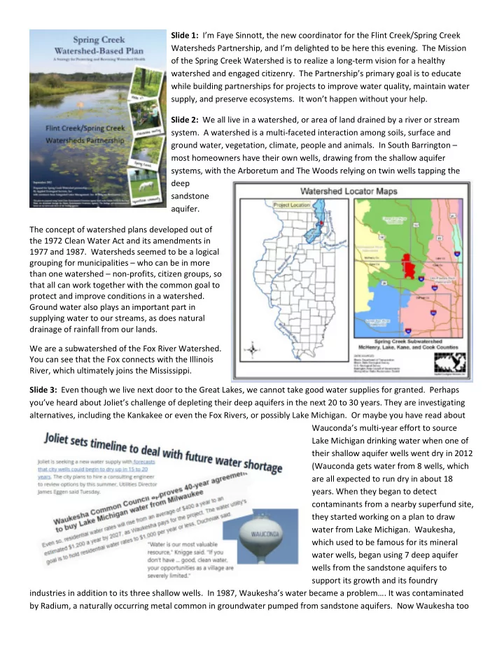
ground water, vegetation, climate, people and animals. In South Barrington – most homeowners have their own wells, drawing from the shallow aquifer systems, with the Arboretum and The Woods relying on twin wells tapping the deep sandstone aquifer. The concept of watershed plans developed out of the 1972 Clean Water Act and its amendments in 1977 and 1987. Watersheds seemed to be a logical grouping for municipalities – who can be in more than one watershed – non-profits, citizen groups, so that all can work together with the common goal to protect and improve conditions in a watershed. Ground water also plays an important part in supplying water to our streams, as does natural drainage of rainfall from our lands. We are a subwatershed of the Fox River Watershed. You can see that the Fox connects with the Illinois River, which ultimately joins the Mississippi. Slide 3: Even though we live next door to the Great Lakes, we cannot take good water supplies for granted. Perhaps you’ve heard about Joliet’s challenge of depleting their deep aquifers in the next 20 to 30 years. They are investigating alternatives, including the Kankakee or even the Fox Rivers, or possibly Lake Michigan. Or maybe you have read about Wauconda’s multi-year effort to source Lake Michigan drinking water when one of their shallow aquifer wells went dry in 2012 (Wauconda gets water from 8 wells, which are all expected to run dry in about 18

  • years. When they began to detect

contaminants from a nearby superfund site, they started working on a plan to draw water from Lake Michigan. Waukesha, which used to be famous for its mineral water wells, began using 7 deep aquifer wells from the sandstone aquifers to support its growth and its foundry industries in addition to its three shallow wells. In 1987, Waukesha’s water became a problem…. It was contaminated by Radium, a naturally occurring metal common in groundwater pumped from sandstone aquifers. Now Waukesha too

slide-2
SLIDE 2

will be pulling Lake Michigan water, but it is considered a water LOAN, as it must treat and return its wastewater via the Root River that drains to Lake Michigan. There are limits as to how much water can be drawn from the Great Lakes, as there are treaties with Canada, and agreements with the other Great Lake states. Most of the Barringtons draw from area shallow aquifers, along with the noted twin deep aquifer wells supplying the Arboretum and The Woods in South Barrington. We should all be mindful that good quality water resources are not unlimited. Slide 4: As most of you know, aquifers replenish slowly. Shallow aquifers recharge1 faster than deep aquifers – which can take thousands of years. Here is a map that was created by BACOG, the Barrington Area Council of Governments, several years ago as they mapped our area (including both the Spring Creek and Flint Creek Watersheds) according to our soils and geography, identifying where the infiltration rate is high – possibly a matter of days in the Loamy Sand or Sandy Loam areas – the reddish areas; or very slow as in decades or longer - the purple areas where there is a lot of Clay Loam, Silty Clay or Clay, as well as in-between (Silt Loam or Loam). Soils also affect our surface waters…. Their erodibility resulting in sediment contamination, or their ability to absorb and retain water, that is, whether they are “hydric” or not. Logical question: How do we know if our aquifers are getting low? BACOG and the Watersheds Partnership are creating a network of monitoring wells and stream gages to better understand how our surface water and groundwater

  • interrelate. That’s a story for another time, as it takes some years to build the stream gage network and to compile the

data to see trends and relationships. We have stream gages locations in both watersheds, and South Barrington also has

  • ne of the continuous data monitoring wells. That’s part of the supply part of the equation. Naturally water use is a
slide-3
SLIDE 3

component, and that’s an obvious place for c shallow aquifer in one location can affect not It's especially important to be mindful if one in hours or days, as can those human-introdu Slide 5: We appear to be headed into a perio

  • spells. This variability can spell potential trou

– wetland areas – that soak up flood waters River front properties are lovely, but develop especially with native planting prevents pollu have very shallow root systems; they do very water flowing into the stream network to help decrease erosion and sediment transport. Lakeshore buffers of native plantings

  • perate similarly,

filtering many pollutants from reaching the lake waters, as well as stabilizing shorelines, and affording protection from normal or win

  • Manage fertilizer use. Avoid

phosphorus when soil testing phosphorus). Don’t fertilize for coordination with area residents. Drawing down or t not only your well water but the entire neighborhood’

  • ne lives in the rapid recharge areas. Rain in those area

roduced contaminants such as motor oils, solvents, che period of greater climate variability, with more intense trouble for a place like Barrington, as we have lost man ers, as well as space where water can collect without da elopments should be designed so there is a larger marg the opportunity to let natural processe detention basins, multiuse open area s and so forth. Municipalities can develo that creatively use low development st floodplains and wetlands, and permit porous pavements in parking lots, side Zoning regulations can allow for the str plantings in rain gardens, bioswales, st roadside buffers, lakeside and Creeksid appropriate deep-rooted native plants these are all strategies that use natura are much more economic over the long and tax paying residents. Slide 6: Residents are important playe water quality of our streams and lakes Forest Preserve is a major landowner, t private landowners whose property lie area lakes. Protecting the stream netw pollutants from reaching the stream network in the first very little to filter pollutants. Native buffers also slow d wind-driven wave action. There are other actions land void over fertilizing lawns adjacent to streams or lakes, sting shows that it is necessary (Illinois soils are general ilize if rain is expected within a day or two. n or contaminating the

  • od’s.

areas can reach the aquifers chemicals and salts. nse rains, and longer dry many of our natural sponges ut damaging structures. argin of safety, as well as esses work through ea serving as flood plains, velop comprehensive plans nt strategies to protect it innovations such as sidewalks and some roads. strategic use of native storm-water ditches and kside buffers using ants (the key is deep roots) – tural ecosystem services that long term for municipalities layers in protecting the

  • kes. While the Cook County

er, there are also many y lies along Spring Creek or network through buffers, first place. Turf grasses

  • w down the movement of

landowners can take as well: kes, and only use rally pretty rich in

slide-4
SLIDE 4
  • Avoid dumping yard and pet waste into waterbodies. Clippings and leaves have loads of phosphorus, a

major nutrient and cause of algal growth, and pet waste has E.coli, neither of which are beneficial.

  • Remove non-native species, such as buckthorn, teasel, reed canary grass. In addition to shading out

beneficial species, shallow-rooted buckthorn’s berries have very little nutritional benefit for wildlife, and recent research suggests their leaves cause abnormalities in amphibians.

  • Use less salt on driveways and walks in the winter. Chlorides stay in the environment; they do not
  • degrade. Chloride reduces soil’s ability to retain water, and in large amounts is toxic to aquatic life.
  • Maintain your septic systems, Lake County recommends regular inspections and licensed pumping every

two to three years. Slide 7: Spring Creek is not on the State’s Impaired Waters List. A baseline water quality study was done in 2015, and the consultant observed that the State had never assessed Spring Creek. Fortunately, we are in pretty good shape. Total Dissolved Solids (TDS) was the only water quality indicator for which Spring Creek exceeded State goals, and only by 6%, although Total Phosphorus tested high at the headwaters’ sampling sites. Chlorides are on an upward trend, but below levels of concern. TDS is not considered a primary pollutant (not associated with health effects). It is more an indicator of aesthetic characteristics and an aggregate indicator of the presence of a broad array of chemical

  • contaminants. Water quality in Spring Creek is pretty good, and we want to work with all of you to keep it that way!

At the meeting on May 10, A Citizen’s Guide (Riparian Area Management) from Lake County was distributed. This is available for download at https://www.lakecountyil.gov/DocumentCenter/View/2993/Riparian-Area-Management-a- Citizens-Guide-PDF For more information on groundwater, see www.bacog.org and http://bacog.org/groundwater-resources/program-

  • verview/

The Flint Creek/Spring Creek Watershed Partnership website is under construction, and is located here: http://flintcreekspringcreekwatersheds.org/

1 Recharge is the process by which precipitation reaches and re-supplies the groundwater. After precipitation reaches the ground a

significant portion runs off and/or evaporates. Of the portion that infiltrates the surface soil, most eventually evaporates from the soil or is taken up and used (transpired) by plants. In areas near streams, rivers, ponds and lakes some of the portion that infiltrated the soil will travel through the near surface soils (upper few feet) and become delayed discharges to these water bodies within a few days of the precipitation event. In terms of annual precipitation, runoff and immediate evaporation accounts for approximately 26 and 5 percent of the precipitation respectively. About 69 percent of the precipitation enters the surface soil where 53 percent of the precipitation evaporates from the soil, is transpired by plants, or is discharged by shallow subsurface flow. The remaining 16 percent travels downward through the underlying unconsolidated materials, reaches the groundwater and becomes groundwater recharge