sconset geotextile tube update sconset bluff nantucket
play

Sconset Geotextile Tube Update Sconset Bluff, Nantucket Maria - PowerPoint PPT Presentation

Sconset Geotextile Tube Update Sconset Bluff, Nantucket Maria Hartnett, Associate www.epsilonassociates.com Presentation Outline Project Setting & Need for Erosion Control Project Components Geotubes Sand Mitigation


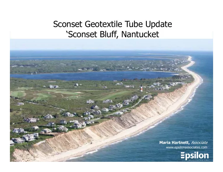
  1. Sconset Geotextile Tube Update ‘Sconset Bluff, Nantucket Maria Hartnett, Associate www.epsilonassociates.com

  2. Presentation Outline • Project Setting & Need for Erosion Control • Project Components • Geotubes • Sand Mitigation • Vegetation • Stormwater Management • Monitoring Program • Conclusions & Next Steps

  3. Project Location Project Location • Project site exposed to full fetch of the Atlantic Ocean • Project site particularly vulnerable to nor’easters

  4. Sconset Bluff • 70-90 feet tall • Glacial origin • Denuded (prior to 2015) • Narrow fronting beach • Vulnerable to wave attack

  5. Sconset Bluff and Storm Waves

  6. Community Setting • Area known as Siasconset (Sconset) • Many historic homes built in late 1800’s and early 1900’s • Served by a single accessway known as Baxter Road • Sankaty Light

  7. Erosion History • Sconset Bluff began eroding in the 1970’s • Erosion is progressing from north to south • Group of residents formed Sconset Beach Preservation Fund (SBPF)

  8. Coastal Bank Retreat • Long-Term Average: 4.6 feet/year • Potential Single Season Loss: 20-30+ feet/year • Winter 2012-2013 resulted in catastrophic erosion 8

  9. Existing Conditions (June 2013) 109-91 Baxter Road Baxter Road • Baxter Road, homes, and associated utilities (water/sewer) in imminent danger • Geotechnical engineer advised closure of road when within 25 feet of bluff edge • Town of Nantucket has legal obligation to provide access to homes • Town of Nantucket and SBPF entered partnership to sponsor erosion control project

  10. Alternatives Many alternatives evaluated in theory and in practice since the 1990’s: Managed retreat (house • moves) Beach dewatering (installed in • 2000 – inconsistent results) Beach nourishment (applied • 2006-2007 – not approved) Marine mattresses and • gabions (applied 2010 – not approved) Biodegradable bags or • envelopes (utilized since mid- 2000’s – useful in smaller storms but not effective in major or successive storms) 10

  11. Geotextile Tube Project • Preferred due to ability to withstand storm waves, sloped design (decreases wave reflection), ease of installation and, if necessary, removal. • Fabricated from high strength, woven polypropylene sewn into a tube shape. • Three-four rows of 45’ circumference geotextile tubes, each about 19’ wide, 7’ tall, and 100-200’ long. • Two phases of construction: three tiers installed in December 2013/January 2014; fourth tier and returns installed October through December 2015. Total length 947 feet.

  12. Construction of Geotextile Tube Project – December 2013/January 2014

  13. Construction of 4 th Tier Geotextile Tube Project – Fall 2015

  14. Construction of 4 th Tier Geotextile Tube Project

  15. Construction of 4 th Tier Geotextile Tube Project

  16. Construction of 4 th Tier Geotextile Tube Project

  17. Construction of 4 th Tier Geotextile Tube Project

  18. Sand Mitigation August 2015 • Protection of bluff prevents it from serving as a sediment source and requires mitigation • Massachusetts typically requires annual mitigation equivalent to average annual contribution • Project provides 22 cy/lf/yr, which is equal to 1.5 times average annual bank contribution • Total volume ~20,000 cy sand/yr May 2015 June 2016

  19. Sand Delivery Sand brought • to the site by dump truck from on-island pits Sand delivery • occurs during off-season months only

  20. Sand Delivery

  21. How Geotextile Tubes Work 2. The sand cover on the geotubes is washed away, contributing sand like the natural bluff would. 1. Wave runup during storms hits the base of the geotubes instead of the base of the bluff. 3. The sand template on the geotubes is regraded so the tubes are covered.

  22. Vegetation  Once the base of the bluff was protected by the geotextile tubes, the face of the bluff could also be stabilized by adding vegetation.  Vegetation helps to prevent erosion from wind, rain, and stormwater runoff.  American Beachgrass planted in spring 2015; additional planting occurred in spring 2016 above the new returns.

  23. Stormwater Drainage System • Top and face of bluff can erode from wind, rain, and stormwater runoff. • In January and February 2016, a drainage system was installed on Baxter Road. This drainage system serves to capture stormwater runoff and redirect it, so that it no longer causes erosion from the top of the bluff. • Berm installed along roadway where needed to redirect stormwater runoff away from the face of the bluff. June 2016

  24. Monitoring Project is extensively monitored, including: • Annual Bluff Monitoring • Quarterly Shoreline Monitoring • Wetland Well Monitoring • Annual Beach • Semi-annual Underwater Invertebrate Monitoring Video Monitoring • Annual Drainage System Report • Annual Sand Delivery Report

  25. Monitoring - Key Findings • Geotube system in place since Jan 2014 – nearly 3.5 years/4 winters • Base of bluff has been stabilized by the geotextile tubes. • Shoreline monitoring data shows shoreline is within range of expected positions based on historic data, with no indication of accelerated erosion in front of or adjacent to the geotubes. • 2016 bluff survey indicates that mitigation sand template is contributing more than the historic contribution rate and the unprotected bluff. • No indication of adverse effect noted in beach invertebrate monitoring, wetland well monitoring, or underwater video monitoring. May 2017 June 2016

  26. Annual Aerial Survey of Bluff To the North: 800 ft unprotected bluff • The first annual aerial survey was performed of the Project area on April 2, 2016. Second annual survey just completed late May 2017. • The results of the 2016 aerial survey were compared to the 2013 aerial survey for those unprotected areas immediately adjacent to the geotextile tube project. • Unprotected bluff contribution volume was 12.9 cy/lf/yr, which is 59% of mitigation volume. Bluff Volume Loss in Unprotected Areas Adjacent to Geotextile Tubes Erosion Volume Length Duration Line Area Rate Lost (CY) (Feet) (Years) (CY/LF/YR) 1 North Unprotected Area 31,329 800 2.75 14.2 2 South Unprotected Area 4,370 210 2.75 7.6 3 Total Bluff Erosion for Adjacent Unprotected Areas 35,699 1,010 2.75 12.9

  27. Summary Geotube Area (2013-2016): • At least 22 cy/lf/yr sand delivered • 18.1 cy/lf/yr contributed • 14.8 cy/lf in template as of April 2016 Unprotected Bluff Areas (2013-2016): • 12.9 cy/lf/yr contributed

  28. Shoreline Monitoring • Shoreline monitoring at 46 transects along 6 miles of shoreline conducted quarterly • Shoreline monitoring measures: • Change in position of the shoreline (MLW line) and • Change in volume • Bathymetry (-5 MLW out to 3,000 feet offshore or -35 MLW isobath) conducted in the spring and fall • >20 years of historical data • No indication of any adverse effect from the geotextile tubes.

  29. Underwater Video Monitoring • Underwater video monitoring at 10 transects immediately seaward of geotextile tubes and adjacent areas

  30. Underwater Video Monitoring – October 2016 June October 5. Sand Waves or Ripples 95%, 9. (Flat Sand 30%, Pebble 5%, Cobble 12. (Pebble 100%). TR-1020. 30%, Boulder 35%). TR-710. Pebbles 5%). TR-400 16. (Flat Sand 45%, Pebble 15%, 21. (Flat Sand 30%, Pebble 14. (Flat Sand 15%, Pebble 50%, Cobble 10%, Boulder 30%). TR-1500. 50%, Cobble 20%). TR-1925. Cobble 35%). TR-1265. Biota : June and October identified invertebrate species, fish species, and marine plant and algal species, with some seasonal variability (spider crabs bury into sediments; black sea bass, scup, and skates move offshore). Branching brown and red algae, bread crumb sponge, and rock crab were dominant biota. No indication of adverse effect on marine biota.

  31. Underwater Video Monitoring Monitoring shows continued prevalence of cobble/bottom habitat located directly offshore of the geotextile tube Project, with no indication that cobble/boulder habitat is being covered by the mitigation sand.

  32. Monitoring Conclusions • Geotextile tubes have stabilized the base of the bluff. • Mitigation sand from the project has contributed more sand than the historic erosion rate and the recent contribution from the unprotected bluff. • Shoreline monitoring data shows no indication of accelerated erosion within or directly adjacent to geotextile tubes. • No evidence of harm observed in wetland well monitoring, beach invertebrate monitoring, and underwater video monitoring.

  33. Next Steps May 2017 • Expand current system to 3400 ft • Review sand source options • Review monitoring program to focus on collecting most useful data • Review mitigation program to consider more adaptive approach

  34. Questions? Photo credits: George Riethof and the Sconset Trust, Rick Blair, Rob Benchley Maria Hartnett, Associate www.epsilonassociates.com 2014

Download Presentation
Download Policy: The content available on the website is offered to you 'AS IS' for your personal information and use only. It cannot be commercialized, licensed, or distributed on other websites without prior consent from the author. To download a presentation, simply click this link. If you encounter any difficulties during the download process, it's possible that the publisher has removed the file from their server.

Recommend


More recommend