
SLIDE 1
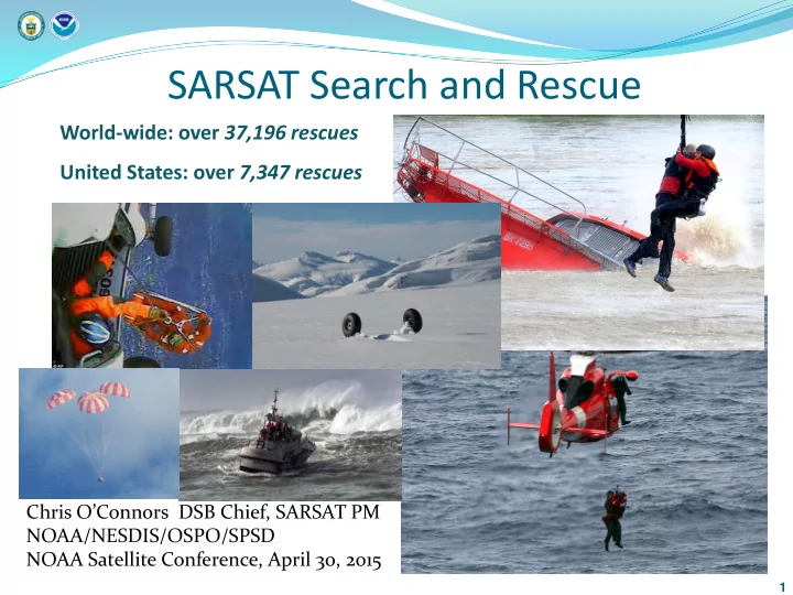
SARSAT Search and Rescue
World-wide: over 37,196 rescues United States: over 7,347 rescues
1
Chris O’Connors DSB Chief, SARSAT PM NOAA/NESDIS/OSPO/SPSD NOAA Satellite Conference, April 30, 2015
SARSAT Search and Rescue World-wide: over 37,196 rescues United - - PowerPoint PPT Presentation
SARSAT Search and Rescue World-wide: over 37,196 rescues United States: over 7,347 rescues Chris OConnors DSB Chief, SARSAT PM NOAA/NESDIS/OSPO/SPSD NOAA Satellite Conference, April 30, 2015 1 Background / History 1967 16-year old girl
World-wide: over 37,196 rescues United States: over 7,347 rescues
1
Chris O’Connors DSB Chief, SARSAT PM NOAA/NESDIS/OSPO/SPSD NOAA Satellite Conference, April 30, 2015
Background / History
1967 16-year old girl dies after two months waiting for rescue 1970 Congress mandates carriage of 121.5 ELT on general aviation aircraft 1972 Congressmen Boggs and Begich lost in Alaska plane crash 1975 Apollo-Soyuz Test Project 1982 COSPAS-SARSAT first rescue 1985 COSPAS-SARSAT Declared Operational 1998 Geostationary space segment becomes
1998 Cospas-Sarsat announces termination of 121/243 MHz service starting in 2009 2009 Termination of 121.5 and 243 MHz processing by space segment
Cospas-Sarsat (C-S) Program uses dedicated Search and
Rescue (SAR) payloads onboard satellites to relay beacons signals to ground stations
C-S system consists of three segments:
User Segment – the emergency beacon transmitters
Marine: EPIRB (Emergency Position Indicating Radio Beacon) Aviation: ELT (Emergency Locating Transmitter) Land: PLB (Personal Locating Beacon)
Ground Segment – Local User Terminals (LUTs) Space Segment
LEOSAR: Low-Earth Orbit - Provides for beacon location using Doppler processing;
uses Store & Forward instrument to provide global coverage
GEOSAR: Geosynchronous Orbit Performs instantaneous alerting function; no
locating capability unless beacon is equipped with GNSS receiver.
MEOSAR*: Mid-Earth Orbit SAR – Under development
3
4
Organization (ICAO) and the International Telecommunications Union (ITU)
5
ELT PLB EPIRB
6
GOES-S GOES-14 (Spare) GOES-R
10 11 12 13 14 15 16 17 18 19 20 21 22 23 24 25 26 27 28 29 30 31 32 33 34 35 36 MetOp-A/S-11
MetOp-B/S-13
N19/S-12
(purple=USA; green=EUMETSAT/EU; gold=Russia)
GEOSAR MEOSAR
N15/S-7 GOES-13
continued operation
COSPAS-13 COSPAS-14
LEOSAR
GOES-15 GOES-T GOES-U GPS II F DASS (S-Band)
SAR/GLONASS
SAR/Galileo
GPS III SV1-8 (S-Band)
GPS III SAR/GPS SV-11+ SIDAR
GPS IV
N18/S-10
IOC
FOC
MEOSAR schedule
Current U.S. Local User Terminals (LUTs)
Maryland* Miami Alaska Hawaii Guam California
USCG COMMSTA Honolulu 2 LEOLUTs 6 antenna MEOLUT Vandenburg AFB Andersen AFB 2 LEOLUTs NOAA FCDA 2 LEOLUTs NOAA NSOF USCG COMMSTA Miami 2 LEOLUTs 6 antenna MEOLUT
*Maryland has 3 GEOLUTs & 1 LEOLUT US Mission Control Center
7
Current SARSAT systems requires 4 Low Earth Orbiting (LEO) satellites
LEOSAR
hours with 5 km accuracy Search and Rescue Global Position System (SAR/GPS) Medium Earth Orbiting Search and Rescues (MEOSAR) vastly improves capability
Location
1st Gen 1KM 2nd Gen 100-500m
Distress Alerting Satellite System (DASS) Proof-
and IIF SVs
8
Based on the use of SAR Repeaters carried on board Global
Navigation Satellite System (GNSS) satellites
Global Navigation constellations consist of 24 (or more) satellites
Mid Earth Orbit (GPS, Galileo, GLONASS)
Provides
Near instantaneous beacon detection and location,
globally, at all times
Advanced location process using time and frequency measurements of
beacon signal to triangulate its location
Mitigates terrain blockage due to multiple look angles
from multiple moving satellites
Robust space segment, well maintained and highly
redundant
Simple space segment repeater allows for
development of higher performance beacon signal
9
Next generation of satellite-aided SAR
10
Message sent by the distress beacon (specific RLS protocol on the 406 MHz uplink signal) to the RLS Provider (RLSP) to indicate it has a Return Link capability
11
12
Project Goals
meet or exceed C/S requirements, including:
Progress to date
Location accuracy meets C/S SGB requirements for location accuracy: shows that at least 95%
minute average are within the 100m (red) circle order of magnitude improvement from first generation beacons
signal transmitted over 48hr period (1 burst every 50
sec) through DASS;
NASA MEO ground station
SGB locations over 2-day duration
13
14
http://www.sarsat.noaa.gov http://www.cospas-sarsat.int