
SLIDE 1
1
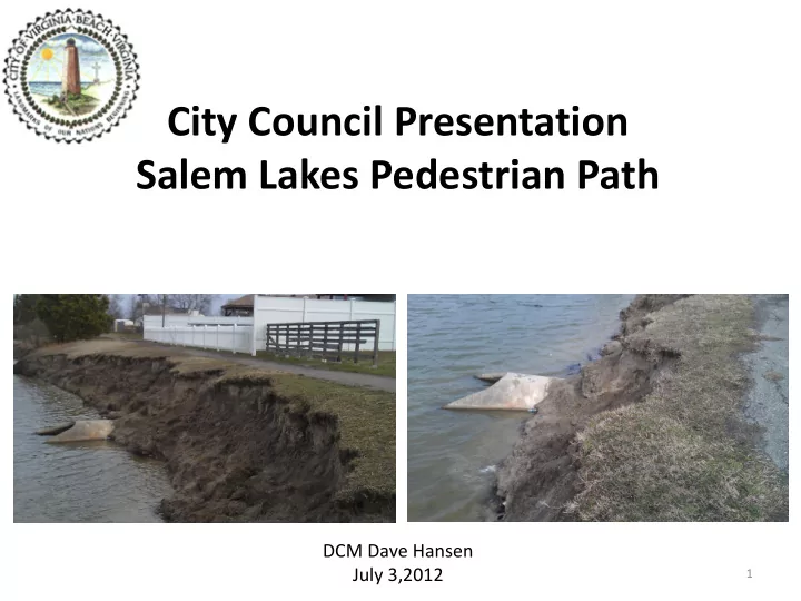
City Council Presentation Salem Lakes Pedestrian Path
DCM Dave Hansen July 3,2012
Salem Lakes Pedestrian Path DCM Dave Hansen July 3,2012 1 SALEM - - PowerPoint PPT Presentation
City Council Presentation Salem Lakes Pedestrian Path DCM Dave Hansen July 3,2012 1 SALEM LAKES PROPERTY LINES PREE LN 3900 - 3935 PREE LN 3900 - 3935 PREE LN 3900 - 3935 A PREE LN 3900 - 3935 N N N N REE LN 3900 - 3935 N
1
DCM Dave Hansen July 3,2012
NTANA CT 1900 - 1999 TANA CT 1900 - 1999 TANA CT 1900 - 1999 TANA CT 1900 - 1999 TANA CT 1900 - 1999 CENTENNIAL CIR 1922 - 1931 CENTENNIAL CIR 1922 - 1931 CENTENNIAL CIR 1922 - 1931 CENTENNIAL CIR 1922 - 1931 CENTENNIAL CIR 1922 - 1931 COUGAR CT 1808 - 1899 COUGAR CT 1808 - 1899 COUGAR CT 1808 - 1899 COUGAR CT 1808 - 1899 COUGAR CT 1808 - 1899 EWING PL 1800 - 1823 EWING PL 1800 - 1823 EWING PL 1800 - 1823 EWING PL 1800 - 1823 EWING PL 1800 - 1823 EWING PL 1824 - 1899 EWING PL 1824 - 1899 EWING PL 1824 - 1899 EWING PL 1824 - 1899 EWING PL 1824 - 1899 D A R R O W S T 1 D A R R O W S T 1 D A R R O W S T 1 D A R R O W S T D A R R O W S T 1 H U E Y C T 3 8
8 9 9 H U E Y C T 3 8
8 9 9 H U E Y C T 3 8
8 9 9 H U E Y C T 3 8
8 9 9 H U E Y C T 3 8
8 9 9 C E N T E N N I A L C I R 1 8 8 C E N T E N N I A L C I R 1 8 8 6 C E N T E N N I A L C I R 1 8 8 6 C E N T E N N I A L C I R 1 8 8 6 C E N T E N N I A L C I R 1 8 8 6 RNING VIEW DR 3900 - 3926 RNING VIEW DR 3900 - 3926 RNING VIEW DR 3900 - 3926 RNING VIEW DR 3900 - 3926 RNING VIEW DR 3900 - 3926 JOUSTING ARCH 3800 - 3803 JOUSTING ARCH 3800 - 3803 JOUSTING ARCH 3800 - 3803 JOUSTING ARCH 3800 - 3803 JOUSTING ARCH 3800 - 3803 BIG BEAR CT 3800 - 3899 BIG BEAR CT 3800 - 3899 BIG BEAR CT 3800 - 3899 BIG BEAR CT 3800 - 3899 BIG BEAR CT 3800 - 3899 C A R I B O U C T 3 8
8 9 9 C A R I B O U C T 3 8
8 9 9 C A R I B O U C T 3 8
8 9 9 C A R I B O U C T 3 8
8 9 9 C A R I B O U C T 3 8
8 9 9 CENTENNIAL CIR 2119 - 2199 CENTENNIAL CIR 2119 - 2199 CENTENNIAL CIR 2119 - 2199 CENTENNIAL CIR 2119 - 2199 CENTENNIAL CIR 2119 - 2199 CENTENNIAL CIR 1853 - 1866 CENTENNIAL CIR 1853 - 1866 CENTENNIAL CIR 1853 - 1866 CENTENNIAL CIR 1853 - 1866 CENTENNIAL CIR 1853 - 1866 INCA CT 2000 - 2099 INCA CT 2000 - 2099 INCA CT 2000 - 2099 INCA CT 2000 - 2099 INCA CT 2000 - 2099 GREY DOVE LN 3771 - 3799 GREY DOVE LN 3771 - 3799 GREY DOVE LN 3771 - 3799 GREY DOVE LN 3771 - 3799 GREY DOVE LN 3771 - 3799 EWING CT 3800 - 3899 EWING CT 3800 - 3899 EWING CT 3800 - 3899 EWING CT 3800 - 3899 EWING CT 3800 - 3899 ADOBE CT 2000 - 2099 ADOBE CT 2000 - 2099 ADOBE CT 2000 - 2099 ADOBE CT 2000 - 2099 ADOBE CT 2000 - 2099 BUCKHORN PL 3857 - 3899 BUCKHORN PL 3857 - 3899 BUCKHORN PL 3857 - 3899 BUCKHORN PL 3857 - 3899 BUCKHORN PL 3857 - 3899 J O U S T I N G A R C H 3 8 4
8 7 8 J O U S T I N G A R C H 3 8 4
8 7 8 J O U S T I N G A R C H 3 8 4
8 7 8 J O U S T I N G A R C H 3 8 4
8 7 8 J O U S T I N G A R C H 3 8 4
8 7 8 LANTANA PL 3900 - 3931 LANTANA PL 3900 - 3931 LANTANA PL 3900 - 3931 LANTANA PL 3900 - 3931 LANTANA PL 3900 - 3931 N C T 3 9
9 9 9 N C T 3 9
9 9 9 A N C T 3 9
9 9 9 N C T 3 9
9 9 9 N C T 3 9
9 9 9 C O Y O T E C I R 3 8
8 9 9 C O Y O T E C I R 3 8
8 9 9 C O Y O T E C I R 3 8
8 9 9 C O Y O T E C I R 3 8
8 9 9 C O Y O T E C I R 3 8
8 9 9 CENTENNIAL CIR 2052 CENTENNIAL CIR 2052 CENTENNIAL CIR 2052 CENTENNIAL CIR 2052 CENTENNIAL CIR 2052 GENESEE WAY 1900 GENESEE WAY 1900 - GENESEE WAY 1900 GENESEE WAY 1900 GENESEE WAY 1900 C E N T E N N I A L C I R 1 9 6
9 8 7 C E N T E N N I A L C I R 1 9 6
9 8 7 C E N T E N N I A L C I R 1 9 6
9 8 7 C E N T E N N I A L C I R 1 9 6
9 8 7 C E N T E N N I A L C I R 1 9 6
9 8 7 CENTENNIAL CIR 1908 - 1921 CENTENNIAL CIR 1908 - 1921 CENTENNIAL CIR 1908 - 1921 CENTENNIAL CIR 1908 - 1921 CENTENNIAL CIR 1908 - 1921 PREE LN 3900 - 3935 PREE LN 3900 - 3935 PREE LN 3900 - 3935 REE LN 3900 - 3935 PREE LN 3900 - 3935 BUCKHORN PL 3800 - 3856 BUCKHORN PL 3800 - 3856 BUCKHORN PL 3800 - 3856 BUCKHORN PL 3800 - 3856 BUCKHORN PL 3800 - 3856 M L A K E S B L V D 3 9
9 1 M L A K E S B L V D 3 9
9 1 M L A K E S B L V D 3 9
9 1 M L A K E S B L V D 3 9
9 1 M L A K E S B L V D 3 9
9 1
2
following conditions:
the jogging path. The city will assume maintenance responsibility for those areas. HOWEVER, THE CITY WILL NOT ACCEPT MAINTENANCE RESPONSIBILITY FOR THE PROPOSED LAKE.”
area on which the jogging path is proposed. The level area should be at least 15 feet wide with the 6-foot wide jogging path located in the center.”
containing:
wide jogging path is to be centered within the 15’ easement.”
1983 – 1984 – 8 plats recorded at various times, each showing the easement area and dedicating the easement to the City by plat note.
3
– Severity of weather events – Soil conditions – Lack of 7:1 slope
– Briefed City management & district Council member – Posted “Use trail with caution” signs
– Commenced alternatives analysis and cost estimating – Briefed City management & district Council member
4
5
This map shows that there is good pedestrian connectivity in place in Salem Lakes considering sidewalks exist on both sides of Centennial Circle, the main road that surrounds the lakefront lots. The sidewalk network includes other roads connecting in toward the lake off of Centennial Circle. Sidewalk Maintenance - Residents commented that help is needed from the City to cut back lawns that have grown over the sidewalk.
6
7
8
9
All of the lots surrounding the lake are platted to the center of the lake. The City has a 15 foot public easement allowing the public the right to walk along a 6 foot path supposed to be located in the center of the easement. The City has responsibility for the maintenance of the public easement area and the
the public easement. Concerns that the eroding bank has encroached into the public easement because the 6 foot path was portended to be in the middle of the easement. A survey of the public easement and the top of the bank was conducted to determine the location of the path and the degree of encroachment of the bank failure.
10
11
§ 15.2-2271, by ordinance of the governing body.
before Council adoption.
– Ordinance to authorize City Manager to execute necessary documents to vacate easement
– Deeds will be recorded to evidence easement has been vacated in chain
– Eight (8) separate Deeds to coincide with eight (8) subdivision plats recorded during neighborhood development
12
35 were citizens who lived on lakefront property 42 were citizens who lived elsewhere in the Salem Lake neighborhood (not lakefront)
13
assess all other culverts (PW)
permits, need to work with owners who want to do bank stabilization (Planning)
Enforcement and Waste Management)
(City Atty)
involved because of 10” gravity sanitary sewer line)
14
Unkempt yards
Illegal Dumping
violation are issued when a responsible party can be located
responsible party cannot be located Graffiti
readily accessible
15
Planned Patrol to get a sense of scope and severity of problem
Wildlife Specialist
– There is a colony of approximately 20 nutria – These nutria are not responsible for the erosion and pose no threat to public safety – There is a limited natural food source that should keep the population in check – Eradication via trapping will cost approximately $10,000 (via USDA) & there is no guarantee trapping will eradicate a sufficient number to overcome breeding rate or new migration – Trapping is not recommended
along the pedestrian path during future visits.
efforts to eradicate them are often controversial.
property (parks) and staff is prepared to present an ordinance to this Council if necessary which would prohibit feeding waterfowl
– There are several prerequisites to this ordinance including a requirement the feeding activity is creating a nuisance, signs are posted, and DGIF is notified- a letter from the Manager has been prepared.
requirements and applicable review processes
Approval Required; Follow ACOE Permit Processes.
Required; Planning/DSC Must Approve Erosion And Sediment Control Plan Prepared By Licensed Professional; Surety and Permit Required
Floodplain Variance May Be Necessary; Depending On The Extent Of Fill This May Require City Council Approval; Planning/DSC Must Approve Plans And Calculations Prepared By A Licensed Professional
REQUIRED - Structural Plans Must Be Prepared By a P.E.
Planning/DSC Must Approve Site Plan Prepared By Licensed Professional; Surety And Permit Required
multiple lots by qualified licensed contractors to achieve expected results
19
– Duration - Three months including obtaining permits – Obtain right of entry from homeowners as required to perform the work
20
21
1 2 3 4 11 6 5 9 10 8 7 Outfall 3 is submerged
22
Outfall 11 Outfall 10 Outfall 9 Outfall 4 Outfall 2 Outfall 7 Outfall 5 Outfall 6 Outfall 8 Outfall 1
23
24
25
26
Approx 90 linear feet (LF) with TOB within 10 feet of pedestrian easement.
easement.
however, citizens overwhelmingly want it removed.
– Behind 3861, & 3869 Buckhorn Place (Lot 38 & 40) - approx. 95 LF @ 6-10 ft. – Behind 3805 Buckhorn Place (Lot 24)– approx. 20 LF @ 8-10 ft. – Behind 3820 Jousting Arch (Lot 13)– approx. 60 LF @ 7-10 ft. – Behind 3829 & 3825 Buckhorn Place (Lot 30 & 29) - approx. 70 LF @ 6-10 ft
27
28
easement and a pedestrian path around the lake.
BMPs except to protect stormwater infrastructure.
easement (closest is outfall #4).
infrastructure requires considerable private owner and permit approvals.
10 inch sanitary sewer (gravity) crossing (15 feet deep).
29
Manhole ~15 feet deep Sanitary Sewer Crossing ~15 feet deep
31
32
33
34