rwis in odot s winter plan
play

RWIS in ODOTs Winter Plan Overview Our Responsibility 43,000 Lane - PDF document

10/21/2013 RWIS in ODOTs Winter Plan Overview Our Responsibility 43,000 Lane miles Ohio roads carry the 5 th largest volume of traffic in the US $1.3 trillion in freight crosses Ohio annually 33,664 Snow and Ice related


  1. 10/21/2013 RWIS in ODOT’s Winter Plan Overview Our Responsibility  43,000 Lane ‐ miles  Ohio roads carry the 5 th largest volume of traffic in the US  $1.3 trillion in freight crosses Ohio annually  33,664 Snow and Ice related accidents annually ◦ 9,063 Injuries ◦ 53 deaths 1

  2. 10/21/2013 Overview Impacts of Snow and Ice • Budget Impact – $2.3 billion annually nationwide • Essential Services Impacts – Police, medical, fire and rescue, • Individual Impacts – Increased accidents, fatalities, property damage, insurance costs, lost wages • Economic Impacts – Lost productivity, late shipments, additional fuel and lost sales • Environmental & Infrastructure Impact – Over $5 million annually in repairs
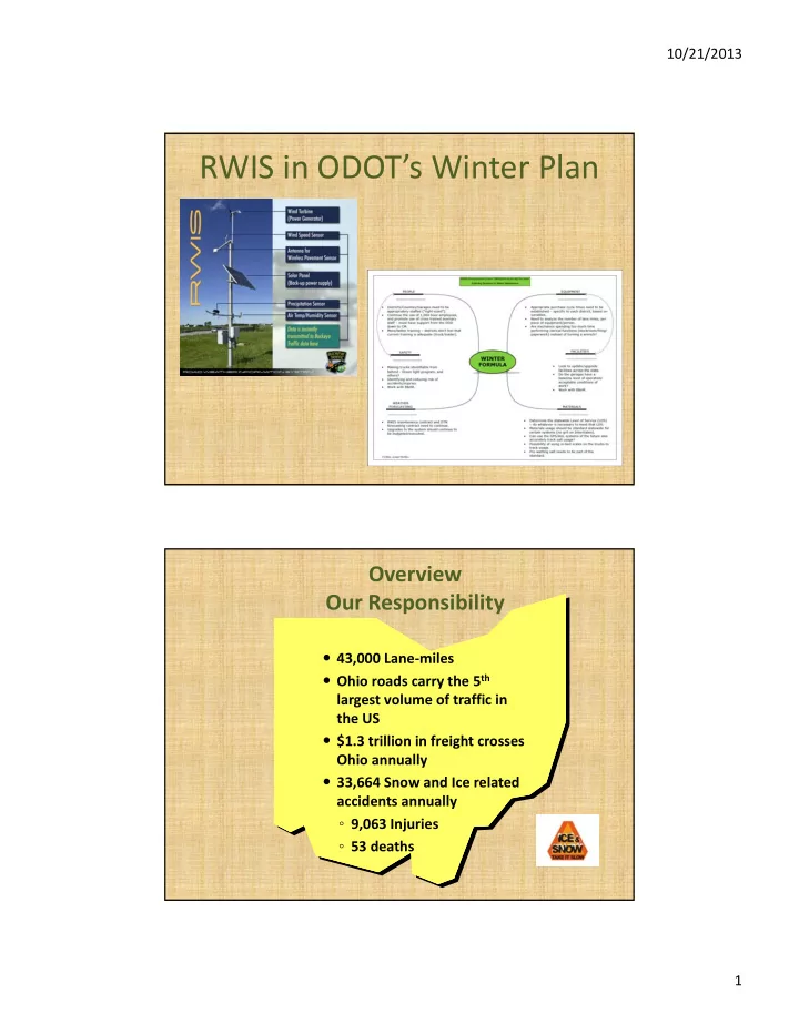
 Overview ‐ Impacts of Snow and Ice Annually, ODOT: Can we really spend $50 Million on Rock Salt per year?  Spends $50 million on rock salt •  Uses over 650,000 tons of salt Cost – 2013 FY average $40.91 per ton  7-9 Million gallons of brine • 8 tons per single axle truck = $327.28  500,000 gallons of other • 3 Loads per truck per shift = $981.84 chemicals • 15 trucks = $14,727.60 per shift  3,000 CDL employees involved in snow • 2 shifts per day = $29,455.20 and ice control • Average of 8 counties per district =  1,700 trucks $235,641.60 per day for just one district  200 garage facilities • There are 12 districts in Ohio = $2.8 million 2

  3. 10/21/2013 Overview Impacts of Snow and Ice 2012/2013 Winter Statistics Stock Usage Equipment Usage Labor Charge 723,205 tons of Salt = $37.5m 27,043 per hr. = $987,800 344,300 OT hr. = $33.7m 731,147 gal. Salt Brine = $158,800 9,767,803 mi. = $24.6 Other Materials = $1.3m 27,798 Aux hr. = $344,900m 445,443 Reg. hr. = $28m $39.4m $25.6 m $62.1m Over $127 m illion in Snow and Ice control costs for the year 3

  4. 10/21/2013 Overview Plowing is the Primary tool for snow & ice removal ODOT Winter Formula – People – Equipment – Materials – Weather 4

  5. 10/21/2013 Materials • Chemicals – Salt (Rock and Brine) – CaCL – Some GeoMelt/IceBite/Clear Lane, etc Equipment • Pre ‐ Trip Inspections • During Ops Inspections • After Ops Inspections • Cleaning 5

  6. 10/21/2013 • Generally Cold Climate • Impact From Lake Erie • Hilly Terrain / Wooded Winter Storms Characterized by: • 8” ‐ 12” Snow Falls • Lake Effect Snowfalls • Lake Enhanced Snowfalls • Heavier Snows • Black Ice • Sleet • Freezing Rain Lake Can Produce Non ‐ Storm Related Snowfalls of 20” or More And Last for Days 6

  7. 10/21/2013 • Generally Coldest Climate • Impact From Lake Michigan • Flat Terrain / Not Heavily Wooded Winter Storms Characterized by: • 3” ‐ 6” Snow Falls • Higher Winds • Heavier Drifting • Black Ice • Sleet • Freezing Rain Higher Number of ‘Nuisance’ Snow Falls of 2” or Less from Lake and Clippers. • Generally Milder Climate • Less Impact From Lakes • Partially Shielded By Mountains Winter Storms Characterized by: • 1” ‐ 3” Snow Falls Mixed With: • Black Ice • Sleet • Freezing Rain • Ice Mist or Fog Brining is Difficult Because Most Big Storms Begin as Rain, Then Changes. 7

  8. 10/21/2013 • Ridged Topography Around City Winter Storms Characterized by: • 1” ‐ 3” Snow Falls Mixed With: • Black Ice • Sleet • Freezing Rain • Ice Mist or Fog Columbus Area Winter Storms Can Be Impacted Any Region Depending Storm Makeup And Track. TWO KEY SNOW & ICE QUESTIONS: “What Am I Going To Get?” Composition • Precipitation Type? • Intensity? • Wind? AND AND “When Am I Going To Get It?” Timing • Begins? • Changes? • Ends? 8

  9. 10/21/2013 Watching Winter Conditions 1. Take Notice of Potential Events 3 ‐ 5 Days Out a. NWS Forecasts, Private Forecast Services, etc. 2. Monitoring forecast progression a. Lead time for maintenance or repairs b. Stock up on resources (fuel, salt, etc.) c. Plan for potential upcoming snow and ice shifts WHAT GOES INTO A FORECAST? • Data • Discussions Data: 500 mb Forecast (2 Models)  15,000 Ft Upper Level Flow, Euro and GFS 9

  10. 10/21/2013 No Forecast is Perfect! Sudden Forecast Changes, or Complete Misses are Not Uncommon: This can lead us to: 1) Scramble or Recall Crews What ??? The forecast said 2) Change Operational Tactics ‘Partly Cloudy!’ (Storm Makeup) 3) Adjust Staffing (Long storms) Weather in Real Time NWS Radar NWS Satellite NWS Surface Observations RWIS 10

  11. 10/21/2013 Radar NWS NWS Radar is Radar is 10,000 ft at 10,000 ft at 120 miles 120 miles Detroit Cleveland Ft. Wayne Pittsburgh Wilmington Charleston Radar Snow & Sleet are lower in the Snow & Sleet are lower in the atmosphere. atmosphere. Effective distance for Snow: 100 Miles Effective distance for Snow: 100 Miles Detroit Radar Gap Radar Gap Cleveland Ft. Wayne Pittsburgh Wilmington Charleston 11

  12. 10/21/2013 Radar Radar Gap Radar Gap Winter Storms in Winter Storms in Ohio Travel Ohio Travel Approximately Approximately 35mph 35mph How Does RWIS Work? Time - 4:30 AM 30 28 8 3 Toledo I-70 0 2 I-75 34 ← Pavement Temperature I-71 7 ← Precipitation Situation 32 33 Cleveland 1 ← Air - Dewpt Difference 3 8 30 I-77 RWIS Add. Sites 5 0 7 5 35 33 7 8 0 0 n/a 7 33 32 7 7 8 0 0 33 30 33 7 8 7 0 0 0 33 32 33 34 32 33 36 33 8 7 7 7 8 8 7 7 Dayton Columbus 1 0 0 0 0 0 0 13 1 33 7 35 33 0 7 8 0 0 34 34 7 7 0 0 34 33 7 7 3 36 0 Precipitation Situation 7 1 - other 9 - snow heavy 0 2 - unknown 10 - rain slt Radar 3 - no precip 11 - rain mod Cincinnati 32 4 - unidentified slt 12 - rain hvy 7 5 - unidentified mod. 13 - frz precip slt 38 38 2 13 6 - unidentified hvy 14 - frz precip mod 10 2 7 - snow slt 15 - frz precip hvy 2 8 - snow mod 12

  13. 10/21/2013 Freezing rain, drizzle & sleet Snow & Sleet are lower in the Snow & Sleet are lower in the atmosphere. atmosphere. Effective distance for Sleet: 50 Miles Effective distance for Sleet: 50 Miles Satellite Visible Infra Red Water Vapor 13

  14. 10/21/2013 NWS Surface Observations (Can Help To Verify Radar Returns) 14

  15. 10/21/2013 NWS Surface Observations (Can Help To Verify Radar Returns) ….and now, a word about Black Ice…… 15

  16. 10/21/2013 …and that word would be……. “Uh ‐ Oh!” March 5, March 5, 2012 – 2012 – Central Ohio entral Ohio Pavement Temperature Determines Type, Timing & Duration of S&I Operations 16

  17. 10/21/2013 Black Ice Due to Warm Air Advection 50 40 Temperature (F) Pavement 30 Air Temp 20 Dewpoint 10 0 6pm Midnight 5am 7am Time Black Ice Due Cold Sub ‐ Surface 35 30 Air Temperature Pavement 25 Dew Point 20 15 20:00 21:00 22:00 23:00 0:00 1:00 2:00 3:00 4:00 5:00 6:00 7:00 8:00 17

  18. 10/21/2013 RWIS ( Road & Weather Information Systems) RWIS • 172 Sites • 5 Minute Updates • All Counties • Air Temperature • Dew Point • Relative Humidity • Precipitation Type • Wind Direction & Speed • 450+ Surface & Sub Surface Sensors • Pavement Temperatures • Pavement Conditions 18

  19. 10/21/2013 ODOT RWIS What Is RWIS? • Surface Observations with: • Actual Pavement Temperature • Actual Pavement Condition • Sub ‐ Surface Temperature • Located on Our Highway System RWIS Precipitation: (Snow / Freezing Rain) Temperatures Green = Air Blue = Dew Point Red = Surface Surface Condition Green = Dry Surface Blue = Wet > 34 deg Yellow = Wet < 34 deg /w Salt Detected Red = Wet/<34deg/No Salt Detected 19

  20. 10/21/2013 Comments or Questions? THANKS! abner.johnson@dot.state.oh.us RWIS Coordinator Ohio Department of Transportation 614-466-4859 20

Download Presentation
Download Policy: The content available on the website is offered to you 'AS IS' for your personal information and use only. It cannot be commercialized, licensed, or distributed on other websites without prior consent from the author. To download a presentation, simply click this link. If you encounter any difficulties during the download process, it's possible that the publisher has removed the file from their server.

Recommend


More recommend