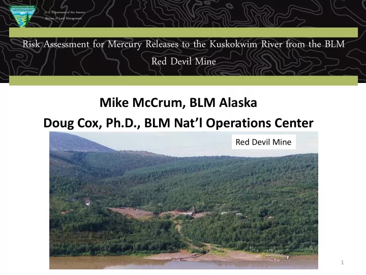
red devil mine
play

Red Devil Mine Red Devil Mine Mike McCrum, BLM Alaska Doug Cox, - PowerPoint PPT Presentation

U.S. Department of the Interior Bureau of Land Management Risk Assessment for Mercury Releases to the Kuskokwim River from the BLM Red Devil Mine Red Devil Mine Mike McCrum, BLM Alaska Doug Cox, Ph.D., BLM Natl Operations Center Red Devil


  1. U.S. Department of the Interior Bureau of Land Management Risk Assessment for Mercury Releases to the Kuskokwim River from the BLM Red Devil Mine Red Devil Mine Mike McCrum, BLM Alaska Doug Cox, Ph.D., BLM Nat’l Operations Center Red Devil Mine 1

  2. U.S. Department of the Interior Bureau of Land Management Organization of Presentation • Discussion of Site setting and the Kuskokwim River  History of mercury mining activities • Initial investigations and RI study  Early response action - 2014 • Fish telemetry and tissue study • Supplemental RI data collection • Human health risk assessment  Multiple lines of evidence • Consideration of findings  Risk management recommendations 2

  3. U.S. Department of the Interior Bureau of Land Management Introduction • Mercury and other site contaminants from Red Devil Mine have been detected in Kuskokwim River media • The methylation of mercury and food chain biomagnification can impact upper food chain organisms, such as pike and burbot  leading to concerns about human health risk (esp. subsistence) from consumption of contaminated fish • This presentation describes a “Multiple Lines of Evidence” approach developed to incorporate a number of site-specific findings into risk management decision making 3

  4. U.S. Department of the Interior Bureau of Land Management Kuskokwim River • Drains much of southwest AK • Ninth largest river in North America • Average discharge is 67,000 cfs 4

  5. U.S. Department of the Interior Bureau of Land Management Kuskokwim River at Red Devil, June 2015 Linear shorelines High Turbidity Strong current Few shoreline wetlands 5

  6. U.S. Department of the Interior Bureau of Land Management Important Site Issues Related to RDM and the Kuskokwim River Numerous Mercury • Deposits Elevated Background • Mercury Fish are Important Local • Source of Protein Elevated Mercury in • Resident Fish 6

  7. U.S. Department of the Interior Bureau of Land Management Historic Ore Processing Area, Red Devil Mine Kuskokwim River 7

  8. U.S. Department of the Interior Bureau of Land Management Remedial Investigation Findings RI conducted between 2009 – 2014, and concluded • The RDM is a source of heavy metals contamination to site soils, groundwater, surface water, and sediments • Contaminants are migrating offsite through groundwater and surface water transport • Transport of contaminated sediments in Red Devil Creek has affected sediments in the Kuskokwim River • Potential risks to human and ecological receptors were identified  Primary COCs are arsenic, antimony, and mercury 8

  9. U.S. Department of the Interior Bureau of Land Management Mercury in Kuskokwim River Sediment Mercury Concentration Range Total Mercury <0.0062 mg/kg to 310 mg/kg Mouth of Red Devil Creek Methylmercury <0.01 to 3.73 ng/g – Sediment concentrations upstream are low – Highest concentrations at the mouth – Sediment concentrations generally decrease downstream 9

  10. U.S. Department of the Interior Bureau of Land Management Early Action – stockpiled and graded tailings 10

  11. U.S. Department of the Interior Bureau of Land Management Early Action – Realignment of Red Devil Creek 11

  12. U.S. Department of the Interior Bureau of Land Management BLM/US F&W Telemetry Study Area in Kusko Watershed • Pike – Sedentary • Burbot – Mobile • Few fish near Red Devil Mine 12

  13. U.S. Department of the Interior Bureau of Land Management Fish Tissue Concentrations - Total Mercury 0.8 0.7 Northern Pike Burbot 0.6 0.5 Total mercury 0.4 (mg/kg, ) * 0.3 0.2 0.1 0 Kusko-Aniak George Kusko above Holitna Kusko-Stony Kusko above Takotna George Selatna 2/27 Maximum Use Watershed * Section of the Kuskokwim where Red Devil Mine Is located 13

  14. U.S. Department of the Interior Bureau of Land Management Human Health Risk Questions for RDM and Kuskokwim River • Is mercury from RDM being methylated and getting into the Kusko River food chain?  Is the issue site-specific or regional in nature? • Are local subsistence populations at risk from consuming MeHg in Kusko River fish? • Why is mercury the primary concern?  Cinnabar ore  Hg  MeHg  food chain bioaccumulation  human exposure  potential toxicity  Other COCs – arsenic (As), antimony (Sb) • Toxic but not bioaccumulative 15

  15. U.S. Department of the Interior Bureau of Land Management Multiple Lines of Evidence (MLOE) • Reviews the evidence for a causal relationship between a project hypothesis and observed impacts for a number of endpoints • Supports decision making by incorporating a wide range of data to develop an overall evidence-based conclusion • Widely used approach to evaluate a large amount of data in support of environmental decision making • At Red Devil, will help distinguish between regional and site-specific issues 16

  16. U.S. Department of the Interior Bureau of Land Management Lines of Evidence Evaluated in the Risk Assessment • Hazard Identification  Site characteristics, regional and local background, sediment data • Exposure Assessment  Telemetry data, fish tissue, local fishing patterns • Toxicity Assessment  Sediment toxicity tests, periphyton, site-specific bioaccumulation factors • Risk Characterization  RI and Supplemental RI, ADEC statewide fish monitoring report, source control efforts 17

  17. 18

  18. U.S. Department of the Interior Bureau of Land Management Hazard Identification: Site and Kuskokwim River Characteristics • Red Devil Mine is located in a highly mineralized region of Alaska  Naturally occurring background levels important to project • The flow volume from Red Devil Creek is a minor contributor to the Kusko • The reach of the Kuskokwim near Red Devil is generally poor habitat for game fish of interest  Few wetlands, cobbled bottom, very turbid 19

  19. U.S. Department of the Interior Bureau of Land Management Chemical and Biological Mercury Levels in the Kuskokwim River • While there is a measurable and biologically significant elevation of mercury and arsenic in fish and insects in Red Devil Creek, similar levels are found near other abandoned mines in the middle Kuskokwim River watershed • Percentage of readily bioavailable mercury in sediment samples is low, typically less than 1% of total mercury  However, the amount of Hg historically released into the river from Red Devil provides ample Hg for methylation even if overall rates are low 20

  20. U.S. Department of the Interior Bureau of Land Management Periphyton Mercury Tissue Data Methylmercury was not detected in tissue samples collected from periphyton communities in vicinity of Red Devil Mine Periphyton data suggest that mercury released from Red Devil Mine have not resulted in greater methylmercury levels in the base of the aquatic food web in the Kuskokwim River 21

  21. 22

  22. U.S. Department of the Interior Bureau of Land Management Exposure Assessment: Populations, Pathways, and Assumptions Supplemental Risk Assessment will consider:  Residents (adult and child)  Recreational or Subsistence User (adult and child)  Industrial/mine worker  Dermal contact with sediments  Incidental ingestion of sediments  Fish ingestion (pathway of primary interest) Based on approaches from 2014 RI report  Combination of default and site-specific assumptions 23

  23. U.S. Department of the Interior Bureau of Land Management Kuskokwim Fishing Patterns - Pike • Pike frequent tributaries with low energy habitat • Kuskokwim habitat poor for pike 24

  24. U.S. Department of the Interior Bureau of Land Management Kuskokwim Fishing Patterns - Burbot • Burbot migrate hundreds of miles each year • Local fishermen catch burbot in Kuskokwim in winter 25

  25. U.S. Department of the Interior Bureau of Land Management Subsistence Fish Consumption Issues • Fish of Interest for Human Consumption  Pike, Burbot (most preferred species)  Sheefish, Arctic Grayling, other whitefish, salmonids • Alaska Dept of Fish and Game (ADFG) did a survey of consumption rates and types of wild food used by Red Devil Village residents • Multiyear telemetry and fish tissue MeHg study done for pike and burbot in the middle Kusko region 26

  26. U.S. Department of the Interior Bureau of Land Management ADEC Statewide Pike and Burbot Data and State Fish Consumption Advisories • Total Hg tissue levels in pike and burbot from the middle Kusko are consistent with the median 2001- 2016 statewide tissue levels reported by ADEC (http://dec.alaska.gov/eh/docs/vet/Fish/MetalsResults/TotalMercuryInAlaskanFish.pdf) • State of Alaska Epidemiology Department has issued fish consumption advisories for Hg across the state  For women of childbearing age and children in the Middle Kuskokwim area, it is recommended to eat more fish < 2 feet in length and less of longer fish  Advisories more restrictive in other river systems 27

  27. 28

Download Presentation
Download Policy: The content available on the website is offered to you 'AS IS' for your personal information and use only. It cannot be commercialized, licensed, or distributed on other websites without prior consent from the author. To download a presentation, simply click this link. If you encounter any difficulties during the download process, it's possible that the publisher has removed the file from their server.

Recommend


More recommend