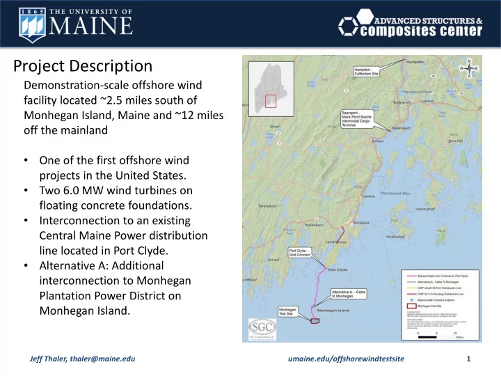
project description
play

Project Description Demonstration-scale offshore wind facility - PowerPoint PPT Presentation

Project Description Demonstration-scale offshore wind facility located ~2.5 miles south of Monhegan Island, Maine and ~12 miles off the mainland One of the first offshore wind projects in the United States. Two 6.0 MW wind turbines


  1. Project Description Demonstration-scale offshore wind facility located ~2.5 miles south of Monhegan Island, Maine and ~12 miles off the mainland • One of the first offshore wind projects in the United States. • Two 6.0 MW wind turbines on floating concrete foundations. • Interconnection to an existing Central Maine Power distribution line located in Port Clyde. • Alternative A: Additional interconnection to Monhegan Plantation Power District on Monhegan Island. Jeff Thaler, thaler@maine.edu umaine.edu/offshorewindtestsite 1

  2. Project Description Jeff Thaler, thaler@maine.edu umaine.edu/offshorewindtestsite 2

  3. Project Description Turbine Assembly and Installation Cofferdam area may be about 10% larger than shown. Jeff Thaler, thaler@maine.edu umaine.edu/offshorewindtestsite 3

  4. Project Description This map shows the Penobscot River tow path from Hampden, ME, to Mack Point in Searsport, ME, as well as two options identified as temporary hull mooring locations while construction is completed. Jeff Thaler, thaler@maine.edu umaine.edu/offshorewindtestsite 4

  5. Project Description Turbine Assembly and Installation Floating foundations would be constructed in a cofferdam along Penobscot River in Hampden, Maine. • Cofferdam excavation and construction ~5 months. • Foundations would take ~1 year to complete. Foundations would be towed to Mack Point Intermodal Cargo Terminal in Searsport for turbine assembly and installation. Complete structure would be towed to the Monhegan Test Site for commissioning. Duration of Project: • Turbine and foundation performance data would be collected for up to five years. • Operate for ~20 years Jeff Thaler, thaler@maine.edu umaine.edu/offshorewindtestsite 5

  6. Project Description Turbines and Foundations Turbines: • Turbine Hub Height: ~328 feet above waterline • Maximum Blade Height: ~576 feet above waterline • Rotor diameter: ~495 feet • Turbine would be painted white • 3–4 chain mooring lines and 3-4 anchors per structure Floating Foundation: • Reinforced concrete with three columns forming a tri-float configuration (semi-submersible) • Extend ~66 feet below waterline • Extend ~44 feet above waterline • Diameter of foundation: ~301 feet • Flashing lights in accordance with U.S. Coast Guard navigation requirements Jeff Thaler, thaler@maine.edu umaine.edu/offshorewindtestsite 6

  7. Project Description Cable Landing Locations Port Clyde, Maine • Export cable would interconnect with existing Central Maine Power (CMP) distribution line. • Landfall Point - Several locations under consideration (~1,200 feet apart). • CMP plans to rebuild ~8.8 miles of distribution line between Port Clyde and Rockland substation. Monhegan Island, Maine (Alternative A) • Landfall Point - Deadman’s Cove or nearby location to connect to a transformer. • Cable would run from transformer underground or overhead on a rebuilt pole line for ~680 feet to Black Head Road. • From Black Head Road cable would run underground for ~650 feet and terminate at the Monhegan Plantation Power District generator/switchgear. Jeff Thaler, thaler@maine.edu umaine.edu/offshorewindtestsite 7

  8. Action(s) Level Agency Permit/Approval Location: Entire Project U.S. Dept. of Energy NEPA process River and Harbors Act, Section 10 Permit; Clean Water U.S. Army Corps of Engineers Act Section 404 Permit National Marine Fisheries Service (NMFS), Endangered Species Act, Section 7 consultation U.S. Fish and Wildlife Service (USFWS) NMFS and USFWS Fish and Wildlife Coordination Act consultation Federal Magnuson-Stevens Fishery Conservation and Entire project NMFS Management Act, Essential Fish Habitat consultation NMFS Marine Mammal Protection Act consultation Federal Aviation Administration Circular I-864 permit Ports and Waterways Safety Act consultation; Private U.S. Coast Guard Aids to Navigation State Maine Historic Preservation Commission Section 106 consultation Natural Historic Preservation Act Location: Offshore Project to Grid Connect Maine Department of Environmental Protection (DEP) General Perimt (38 M.R.S.A. §480-HH) Offshore project to grid connect State Maine Department of Agriculture, Conservation, and Coastal Zone Management Act, Section 307(c)(3) Forestry – Maine Coastal Program consultation (part of DEP permit process) Location: Hampden Cofferdam Natural Resources Protection Act permit (38 M.R.S.A DEP §480) Site Location of Development Act (SLODA) permit (38 DEP M.R.S.A, §§ 481-490) State Construction of cofferdam; DEP Stormwater Permit by Rule (38 M.R.S.A. §420-D) permit dredging of Penobscot River Maine Submerged Lands Program (Maine Department of adjacent to cofferdam Submerged lands lease (12 M.R.S.A. §1862) - Dredging Agriculture, Conservation and Forestry - Division of Parks of Penobscot River adjacent to cofferdam and Public Lands) Town of Hampden Municipal shoreland zoning ordinance review Local Town of Hampden Municipal land development permits Jeff Thaler, thaler@maine.edu umaine.edu/offshorewindtestsite 8

  9. Level Agency Permit/Approval Action(s) Location: Searsport Complete construction of turbines; platforms moored to existing cargo terminal; no permanent pier modifications Local NA None required needed; temporary mooring at one or two state owned oil transfer areas Following assembly, temporary mooring at one of the two Harbormaster permit - for temporary construction designated state maintained oil Local Town of Searsport mooring transport areas south of Sears Island Location: Port Clyde/St. George Connection to CMP distribution Maine Department of Transportation Utility Location Permit line State Natural Resources Protection Act permit (38 M.R.S.A Transmission line landfall DEP §480) Landfall; connection to CMP Town of St. George Municipal shoreland zoning ordinance review distribution line Local Landfall; connection to CMP Town of St. George Municipal land development permits distribution line Jeff Thaler, thaler@maine.edu umaine.edu/offshorewindtestsite 9

Download Presentation
Download Policy: The content available on the website is offered to you 'AS IS' for your personal information and use only. It cannot be commercialized, licensed, or distributed on other websites without prior consent from the author. To download a presentation, simply click this link. If you encounter any difficulties during the download process, it's possible that the publisher has removed the file from their server.

Recommend


More recommend