SLIDE 1
Client: Alberta Transportation Date: May 31, 2017 File No.: 13351 E File: \\H\13351\PH77 Page 1 of 4
ALBERTA TRANSPORTATION GEOHAZARD ASSESSMENT PROGRAM PEACE REGION – PEACE RIVER/HIGH LEVEL 2017 INSPECTION
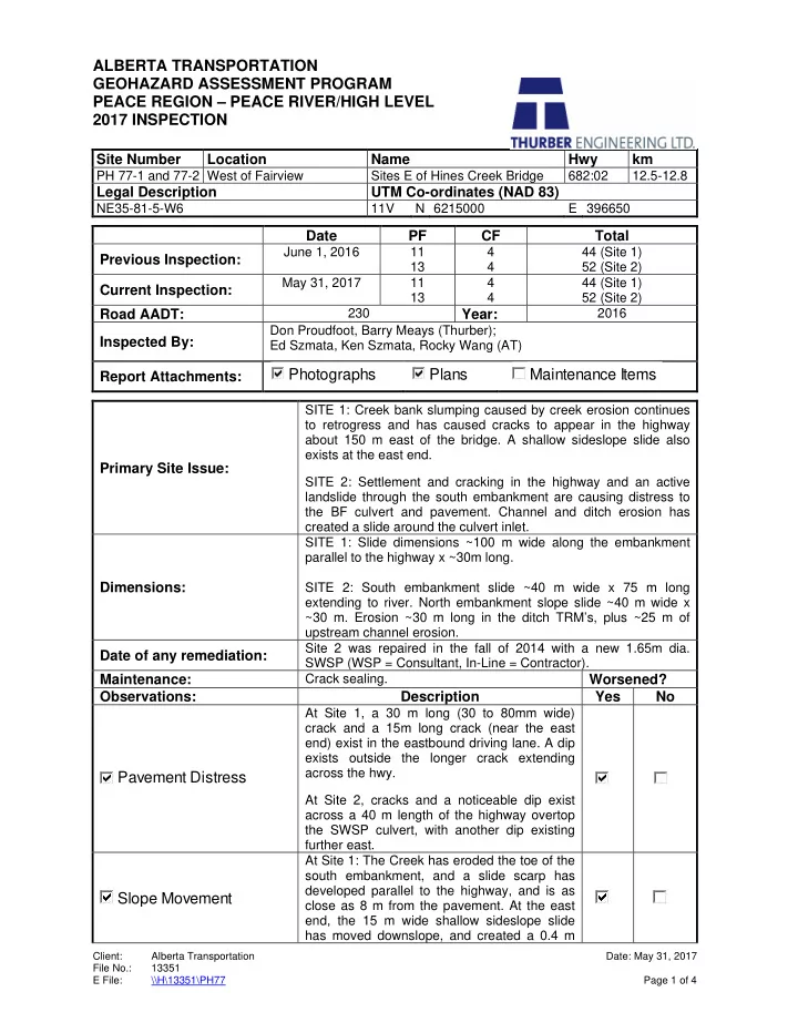
Site Number Location Name Hwy km
PH 77-1 and 77-2 West of Fairview Sites E of Hines Creek Bridge 682:02 12.5-12.8
Legal Description UTM Co-ordinates (NAD 83)
NE35-81-5-W6 11V N 6215000 E 396650
Date PF CF Total Previous Inspection:
June 1, 2016 11 13 4 4 44 (Site 1) 52 (Site 2)
Current Inspection:
May 31, 2017 11 13 4 4 44 (Site 1) 52 (Site 2)
Road AADT:
230
Year:
2016
Inspected By:
Don Proudfoot, Barry Meays (Thurber); Ed Szmata, Ken Szmata, Rocky Wang (AT)
Report Attachments: Primary Site Issue:
SITE 1: Creek bank slumping caused by creek erosion continues to retrogress and has caused cracks to appear in the highway about 150 m east of the bridge. A shallow sideslope slide also exists at the east end. SITE 2: Settlement and cracking in the highway and an active landslide through the south embankment are causing distress to the BF culvert and pavement. Channel and ditch erosion has created a slide around the culvert inlet.
Dimensions:
SITE 1: Slide dimensions ~100 m wide along the embankment parallel to the highway x ~30m long. SITE 2: South embankment slide ~40 m wide x 75 m long extending to river. North embankment slope slide ~40 m wide x ~30 m. Erosion ~30 m long in the ditch TRM’s, plus ~25 m of upstream channel erosion.
Date of any remediation:
Site 2 was repaired in the fall of 2014 with a new 1.65m dia. SWSP (WSP = Consultant, In-Line = Contractor).
Maintenance:
Crack sealing.
Worsened? Observations: Description Yes No
Pavement Distress
At Site 1, a 30 m long (30 to 80mm wide) crack and a 15m long crack (near the east end) exist in the eastbound driving lane. A dip exists outside the longer crack extending across the hwy. At Site 2, cracks and a noticeable dip exist across a 40 m length of the highway overtop the SWSP culvert, with another dip existing further east.
Slope Movement
At Site 1: The Creek has eroded the toe of the south embankment, and a slide scarp has developed parallel to the highway, and is as close as 8 m from the pavement. At the east end, the 15 m wide shallow sideslope slide has moved downslope, and created a 0.4 m
Photographs Plans Maintenance Items
SLIDE 2 Client: Alberta Transportation Date: May 31, 2017 File No.: 13351 E File: \\H\13351\PH77 Page 2 of 4
high scarp (at 3.7 m from the guardrail) and a 0.6 m high toe push. At Site 2: A landslide is developing through the south embankment and has reportedly deformed the culvert. There is a 0.3 m high scarp located 4.6 m from the white shoulder
- line. North of the highway, a 1.0 m wide
graben crack with a 0.2 m drop has developed above the erosion near the culvert inlet.
Erosion
At Site 1, erosion caused by the creek is
- ccurring at the toe of the slope along the
creek’s edge. At Site 2, the TRM south of the highway along the east runoff ditch contains areas of erosion and undermining. North of the highway serious erosion exists in the channel leading up to the culvert inlet, which has undermined the downstream end of the gabions, and there is also 4 m wide x 1.5 m deep erosion/slump at the top of the gabions to TRM transition on the east ditch. The channel upstream of the culvert inlet is also downcut up to 3 m deep x 5 m wide.
Seepage Bridge/Culvert Distress
The ends of the 1.65 m diameter SWSP (BF75380) at Site 2 did not appear to be visibly damaged at the time of our inspection, however the 2015 bridge inspection noted that there were distortions and 2 separations within the culvert (along with low ratings).
Other
Instrumentation:
None
Background/Assessment (Refer to Figures PH77-1, -2, -1/2):
The existing bridge file management system records indicate that BF75380 at Site 2 consisted of a SPE having an in service date of 1961 (the size of the SPE was not identified), with a 15.8 m deck height. Site 2 was repaired in 2012 with a new culvert pipe, and there was some mention of a slide at the site at that time. The soil conditions identified from 2 test holes drilled through the highway as part of the 2012 design repairs indicated a predominant clay fill embankment, overlying a stratified predominant clay deposit, overlying glacial clay till near Creek level. The submitted As-Build drawings indicates that the new pipe was segmented, containing a 108 m long x 1.5 m dia. SPCSP on the upstream (north) embankment; a 157 m long x 1.8 m dia. SWSP through the center and beneath the hwy (a 1.2 m vertical SWSP access culvert was noted on the drawing centered 2 m upstream of the downstream segment end; and an unknown length and dia. of horizontal and vertical elbowed downstream (south) portion (the scaled length from the As-Build drwg ~65 m, and site measurements indicate a 1.65 m
- dia. SWSP exposed outlet). A drawing note described the installation methodology as “Installed
SWSP by augering and jacking through the existing road fill, backfill of culvert ends and other typical details in accordance with Std Drwg S-1418-03.”. Another drawing note indicated “Organic, and soft/yielding materials removed from existing slope failures prior to backfilling”.
SLIDE 3 Client: Alberta Transportation Date: May 31, 2017 File No.: 13351 E File: \\H\13351\PH77 Page 3 of 4
The cracks and subsidence in the south embankment slope are likely evidence that a landslide has formed in the slope at this location. This is supported by reports from AT that the culvert barrel has become distorted and separated, which suggest that the landslide is deep seated. The landslide in the north slope of the highway might have been triggered by loss of toe support due to erosion caused by the tributary creek. Highway ditch runoff erosion (at the TRM/gabion intersections) may have also been contributing factors. There is currently significant settlement observed overtop of the culvert at Site 2, in the form of dips and cracks in the highway. The subsidence and cracking could be the result of embankment fill settlement, but might also be an indication that the slide movement will eventually retrogress towards the highway, or has already. At Site 1, the slide roughly paralleling the creek and highway is a direct result of erosion by Hines Creek and resulting soil loss along the toe of the embankment. The slope will tend to flatten with time due to loss of cohesion in the clay fill embankment material. Therefore, the slide could also gradually enlarge into the south (eastbound) driving lane of the highway surface, and there are already indications of this based on the existing crack and dip in the highway. The smaller 15 m wide slide near the east end of this site may have been triggered by east ditch runoff erosion, and/or having a slope that is too steep for the composition material of the embankment. Ditch or surface erosion of the slope could also contribute to more rapid slope movements.
Recommendations: $ Ballpark Cost
In the short term, regular monitoring of these sites should be undertaken for enlargement. If any of the slides encroach into the shoulders of the highway, barricades should be erected and enhanced with warning signage until highway repairs are undertaken. A temporary detour upslope (to the north of the highway) may also be required depending on the extent of the highway affected. Site 1: In the medium term, the recommended repair for only the small, shallower slide near the east end of the site is to subexcavate the failed slide mass down to intact clay, and rebuild the slope with imported pitrun gravel. The new fill material should be placed and compacted in thin horizontal lifts, benched into the intact slope surface, possibly utilizing a gravel shear key to stabilize the slide area. Some of the more suitable excavated clay could be used to provide a covering layer overtop the gravel as the finished slope surface to shed runoff. A subdrain should be installed along the base of the slide excavation surface, to drain any surface/subsurface water that may enter the rehabilitated slide mass. The east ditch along the toe of this slide should be re-contoured and lined with either TRM or gabions. All existing topsoil should also be stripped and salvaged for replacement and seeded at completion of the repairs. $0.2 Million For the medium to long term, a short highway re-alignment around the affected highway may be
- feasible. In order to meet the existing bridge (~100 m to the west), it would not be able to be a
significant detour, but could work if only a small portion of the highway was affected by a slide. Riprap could also be installed to mitigate future creek erosion. Rock vanes could be considered in conjunction with riprap to reduce the quantity of riprap required. $2 to $3 Million Alternatively, for the long term, due to the anticipated slide depth extending down to creek level and the embankment height (~13 m), a pile wall is feasible at this site. It would need to be a tied back pile wall (multiple anchors/pile), and a detour would be required to the north of the highway during
- construction. Perhaps other measures may be required in addition to the tied back pile wall, such as
- ffloading a portion of the downstream embankment, and/or lightweight fill replacement of soil. A
minimum length of 100 m of pile wall would be required to span the slide length at this site. Riprap should also be installed to mitigate creek erosion. $4 Million
SLIDE 4
Client: Alberta Transportation Date: May 31, 2017 File No.: 13351 E File: \\H\13351\PH77 Page 4 of 4
Site 2: In the short term, a potential repair for the slide on the upstream (north) embankment is to subexcavate the failed slide mass, and re-build the slope entirely with moisture conditioned (dried) clay reinforced by geogrid. This option would require a laydown/preparation area in order to re-use and moisture condition the clay. Additional riprap protection around the existing bridge culvert inlet and in the channel upstream of the culvert would have to be placed. The existing gabion stone along the runoff ditches should be salvaged and re-instated over non-woven geotextile along new contoured ditches beyond the new repaired slope area. A suitable transition should be installed between the gabions and the erosion control soil covering further upslope (such as a steel plate and extended underlays, see PH64 for details), or alternatively (and preferably) consideration should be given to running gabions up the entire ditch slopes. Topsoil salvage will also be required. $0.5 Million For the medium to long term, due to the anticipated slide depth extending down to creek level and the embankment height (~16 m), a pile wall is likely not feasible at this site. A potential long-term solution for the south embankment slope is a highway re-alignment to the north, done in conjunction with the re-alignment for Site 1, before meeting the existing bridge over Hines Creek. A re-alignment could allow some flattening of the south slope leading down to the creek. For this option, the top section of the culvert might need to be re-profiled to remain within the embankment fill and the inlet end of the pipe would need to be extended to allow a shift and flattening of the north embankment slope. $6 Million As a minimum recommendation, at least one test hole drilled on the highway at each site to establish the soil and groundwater conditions is required, in addition to two more test holes complete with piezometer and slope inclinometer installations on the south embankment of Site 2. $150,000 Additional test hole drilling would be required if a highway realignment or a pile wall is considered. The culvert pipe should also be re-inspected for further signs of distress, and the locations of any distress should be surveyed. A topographic survey, detailed design and tender package will also be required prior to carrying out the remedial measures.