N PAHs in sediment Boiler Ponds 1 2 Wastewater Ponds Fire - - PDF document
N PAHs in sediment Boiler Ponds 1 2 Wastewater Ponds Fire Water Pond In fi ltra on Over land fl ow Sur fi cial Aquifer k e e r C n P o e e e d g e r e u t A S q u i f e r LEGEND NAPL Marsh Deposits/Muck
N
NAPL Marsh Deposits/Muck Tan/Yellow Sands Gray Sands and Silt Sandstone Clay Groundwater Table Elevaon Groundwater Flow Direcon LEGEND
Not to Scale
PAHs in sediment
S t u r g e
- n
C r e e k
Over land flow Boiler Ponds 1 2 Wastewater Ponds Infiltraon Fire Water Pond Surficial Aquifer P e e d e e A q u i f e r
EN1028151057WDC GETG_Kerr-McGee_Navassa_CSM_v3.ai 4-4-16 ct
Conceptual Site Model Upland to Marsh Transion Zone
Kerr McGee Chemical Corporaon Site Navassa, Brunswick County, NC
Suspected Pond
Identified in 1975 Photograph
Former Process Area
1965 Aerial Imagery
- 50
- 100
Approximate Elevation
(feet mean sea level)
Aerial Imagery - 2015
Evaporation Pond
" ) " ) " ) " ) " ) " ) " ) " ) " ) " ) " ) " ) " ) " ) " ) " ) " ) " ) " ) " ) " ) " ) " ) " ) " ) " )
! ( ! ( ! ( ! ( ! ( ! ( ! ( ! ( ! ( ! ( ! ( ! ( ! ( ! ( ! ( ! ( ! ( ! ( ! ( ! ( ! ( ! ( ! ( ! ( ! ( ! ( ! ( ! ( ! ( ! ( ! ( ! ( ! ( ! ( ! ( ! ( ! ( ! ( ! ( ! ( ! ( ! ( ! ( ! ( ! ( ! ( ! ( ! ( ! ( ! ( ! ( ! ( ! ( ! ( ! ( ! ( ! ( ! ( ! ( ! ( ! ( ! ( ! ( ! ( ! ( ! ( ! ( ! ( ! ( ! ( ! ( ! ( ! ( ! ( ! ( ! ( ! ( ! ( ! ( ! ( ! (
" ) " ) " ) " ) " ) " ) " )
±
225 45 0 Scal e I n Feet
D ATE: 12/7 /20 15 C R EATED BY: N C C H EC KED BY: KB PN : 65 9368 Fi gur e A – C om pl et ed and P r
- posed
Sam pl i ng Locat i
- ns
Completed SRI Sampling Locations (Sample ID, Total Depth, NAPL Interval)
! (
Tar G O ST, N APL not det ect ed
! (
Tar G O ST, N APL D et ect ed
" )
Soni c Bor i ng, NAPL not det ect ed
" )
Soni c Bor i ng, NAPL D et ect ed Proposed Monitoring Wells:
!
A
Pee Dee Aqui f er
& <
Sur f i ci al Aqui f er
!
A
Pi ezom et er Locat i
- n
" )
Pr
- posed
Vi br acor e Sam pl e Locat i
- n
Existing Permanent Monitoring Wells: Tar G O ST Sam pl i ng Tr ansect O n Si t e R oads Pat hs For m er I m poundm ent
Supplemental Remedial Investigation Work Plan
CH 2M HI LL Nor t h Car
- l
i na, I nc.
Note: Locations of former impoundments are approximate, based on draft Remedial Investigation report developed by AECOM. "S" denotes monitoring well to be screened in shallow perched water.
Kerr-McGee Chemical Corporation Site, Navassa, North Carolina
BASE M AP SO U RC E: ESRI , Ar cM ap I m ager y
- M i
cr
- sof
t , 20 11
D ATE: 12/7 /20 15 D ATE: 12/7 /20 15
PR EPAR ED FO R:
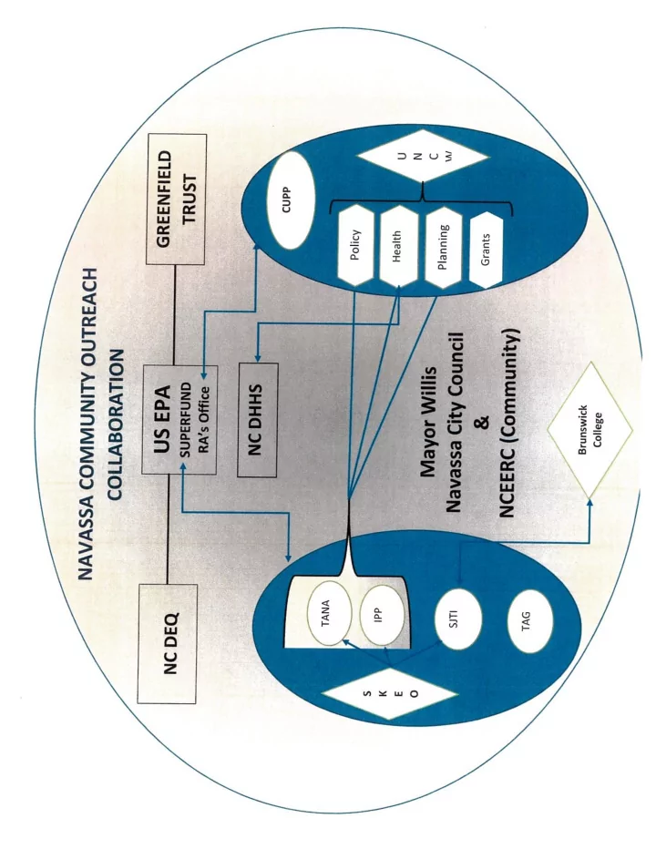
G r eenf i el d Envi r
- nm ent
al M ul t i st at e Tr ust , LLC , Tr ust ee
- f
t he M ul t i st at e Envi r
- nm ent
al R esponse Tr ust
Soni c and Tar G O ST cal l
- ut
s i ncl ude t he f
- l
l
- w i
ng i nf
- r
m at i
- n
f r
- m
t
- p
t
- bot
t
- m :
I dent i f i cat i
- n
Tot al D ept h i n f eet bel
- w
gr
- und
sur f ace R ange
- f
N APL i n f eet bel
- w
gr
- und