Machine Learning for Glacier Monitoring in the Hindu Kush Himalaya - - PowerPoint PPT Presentation

machine learning for glacier monitoring in the hindu kush
SMART_READER_LITE
LIVE PREVIEW

Machine Learning for Glacier Monitoring in the Hindu Kush Himalaya - - PowerPoint PPT Presentation

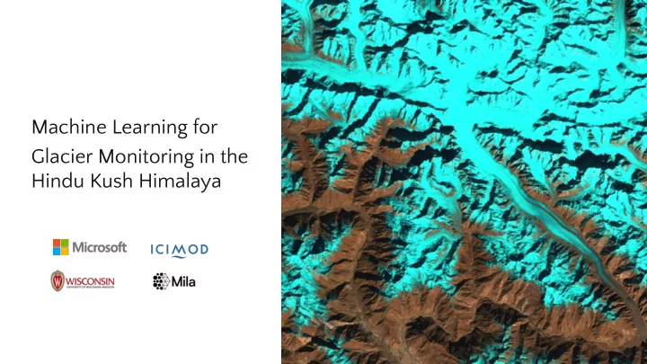
Machine Learning for Glacier Monitoring in the Hindu Kush Himalaya AI for Good Research Lab Background and Motivation Glaciers in the Hindu Kush Himalaya (HKH) are ecologically and societally important, and are at risk due to climate change


slide-1
SLIDE 1

AI for Good Research Lab

Machine Learning for Glacier Monitoring in the Hindu Kush Himalaya

slide-2
SLIDE 2

2

Background and Motivation

  • Glaciers in the Hindu Kush Himalaya (HKH) are

ecologically and societally important, and are at risk due to climate change

  • Monitoring changes is key for water resource and

glacial hazard management

  • The International Centre for Integrated Mountain

Development (ICIMOD) curates a Regional Database System to support glacier monitoring

  • f the HKH
slide-3
SLIDE 3

3

Current Workflow

  • Derive spatial data by semi-automatically annotating landsat images
  • Data are used by scientific and policy communities
  • Labels are available dating back to 1990 and across the HKH

An example of hyperpixel editing in the current labeling workflow.

slide-4
SLIDE 4

4

Problem Description

  • Delineating glaciers is time consuming and challenging to scale
  • Manual interventions are needed to account for cloud cover, variable snow

conditions, and supra-glacial debris

Goal:

  • To effectively demarcate the boundaries of glaciers at different time points
  • Utilize machine learning to accelerate the mapping workflow
slide-5
SLIDE 5

5

Problem Formulation

Given a training dataset, semantic segmentation methods learn to assign pixel-level labels Y over input images X

X: Cropped Landsat image

  • 10 channels from Landsat 7
  • Add NDVI, NDSI, NDWI
  • Add SRTM Elevation / Slope

Y: Pixel-level glacier labels

  • Background
  • Clean ice glacier
  • Debris-covered glacier

X: Input patch Y: Glacier labels

slide-6
SLIDE 6

6

Our Approach

  • Prepare data for modeling
  • Train semantic segmentation
  • Use web tool to incorporate feedback

6

slide-7
SLIDE 7

7

Challenges and Takeaways: Band Selection

  • Best performance per subset of bands.
  • Importance of domain knowledge vs. automatic selection.
slide-8
SLIDE 8

8

Challenges and Takeaways: Error Analysis and Debris Discovery

  • We have compared segmenting

glaciers vs. differentiating segmentation of clear ice glaciers and debris-covered ones.

  • Same overall performance with small

amount of debris-covered data.

  • The gap increases when we have

more debris data. (Up to 16% difference when evaluating for area of more than 10% coverage of debris)

slide-9
SLIDE 9

9

Challenges and Takeaways: Generalization to New Areas

  • How is the model is going to work in
  • ther geographic areas?
  • No performance difference is shown

when restricting testing geographically.

  • There study area might be

homogenous.

slide-10
SLIDE 10

10

slide-11
SLIDE 11

Glacier Mapping Web Tool

slide-12
SLIDE 12

Microsoft Confidential 12

Code & Dataset

Code: https://github.com/krisrs1128/glacier_mapping Data: http://lila.science/datasets/hkh-glacier-mapping

slide-13
SLIDE 13

13

Next Steps

  • Formal comparison with

semi-automated approach

  • Use proposed approach for a

glacier change analysis

1990 2000 2020

slide-14
SLIDE 14

14

Thank you.