SLIDE 4 BUDGET ITEM Personnel: DNR Hydrologist 3, Project Manager (will be either unclassified or, if classified, backfilled with unclassified staff) - 1 FTE/year-July 2011 through June 2013 (salary+fringe) DNR Hydrologist 1, data collection (will be either unclassified or, if classified, backfilled with unclassified hydrologist) - 1 FTE/yr - July 2011 through June 2013 (salary+fringe) Contracts: United States Geological Survey: Hydrologist (Perry Jones) groundwater/surface water models for the Bonanza Valley and for the Buffalo Aquifer pilot study areas, calibration runs, scenario runs, uncertainty analyses, report - (salary+fringe and minor travel, field work and supplies. Does not include USGS "overhead" assessments that are indirectly related to the conduct of the project.) Well driller TBD: well installation and documentation - 12 wells est. @ $5,000/well and 12 @$3,000/well The Freshwater Society and Water Resource Center University of Minnesota: workshops, community involvement, guidance development Uof M, MDH, MDAgric. (existing interagency state contracts) geochemistry/age-dating -
Equipment/Tools/Supplies: Stream Gaging–data logger & pressure transducer, solar panel & regulator, protective enclosure, marine battery, raingage, telecommunications remote equipment, misc. hardware - est. 6 sites/pilot area @ $12,000/site Groundwater level monitoring-data loggers/pressure transducers/sensors 36 @ 750/well Remote, real-time stations-surface gage + 2 wells - 3 sites Bonanza @$15,000/site Geochemical and age-dating - bottles, shipping, field supplies Field laptop computer for specialized for data downloading GIS computer specialized for map creation and data analysis GPS receivers, protective safety and field gear, steel tapes and chalk Travel: In-state - DNR travel for monitoring point installation, data collection, well installation, meeting attendance - Meals and lodging + mileage TOTAL PROJECT BUDGET REQUEST TO LCCMR
AMOUNT Status SOURCE OF FUNDS In-kind Services During Project Period: DNR Area Hydrologists, local contacts - 1/8 FTE/year - July 2011 through June 2013 22,000 $ pending DNR Hydrologist 3, modeler data prep - 1/8 FTE total - July 2011 through June 2013 15,000 $ pending United States Geological Survey - 40% contribution toward models' development - federal contribution used to cover federal overhead costs as well as some direct project costs. 169,000 $ pending City of Moorhead-monitoring levels and sampling, meetings, web development, scenario identification, plan development, public review and adoptions 65,600 $ secured Minnesota DNR's In-kind Contribution: for shared services and governance 49,700 $ non- secured 2,500 $ 45,000 $ 25,000 $ $ 1,000 986,500 $ 5,000 $ 25,000 $ 96,000 $ 254,000 $ 30,000 $ 27,000 $ 3,000 $ 144,000 $
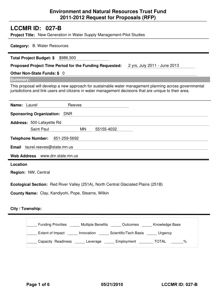
Project Budget
- IV. TOTAL PROJECT REQUEST BUDGET (2 years)
AMOUNT 184,000 $ 145,000 $
Page 4 of 6 05/21/2010 LCCMR ID: 027-B