
SLIDE 1
Gerrymand ndering of C City B Borders
Noah J. Durst School of Planning, Design and Construction Michigan State University
MUNICIPAL ANNEXATION AND THE
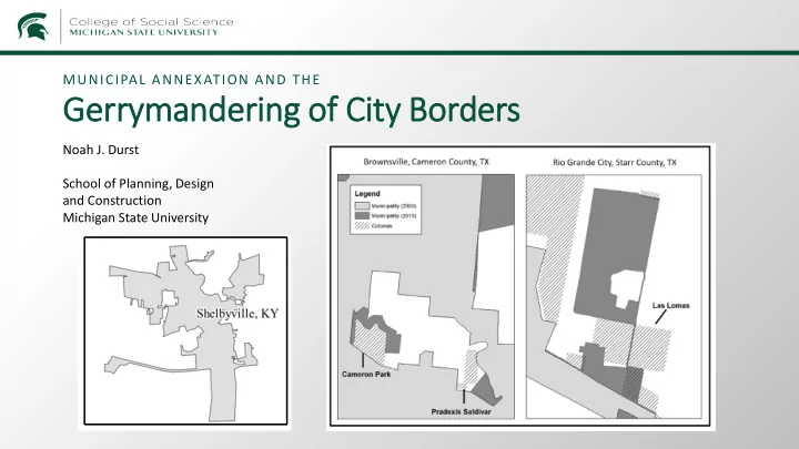
Gerrymand ndering of C City B Borders Noah J. Durst School of - - PowerPoint PPT Presentation
MUNICIPAL ANNEXATION AND THE Gerrymand ndering of C City B Borders Noah J. Durst School of Planning, Design and Construction Michigan State University Annexation from 2011 to 2018 The Gerrymanderi ring o of City Borders Selective ve A
Noah J. Durst School of Planning, Design and Construction Michigan State University
MUNICIPAL ANNEXATION AND THE
neighborhoods are less likely to be annexed.
residents on the fringe control over annexation, black neighborhoods are more likely to be annexed (Durst, 2018)
decreases in the annexation of black neighborhoods (Durst, 2019) EMPIRICAL/METHODOLOGICAL ISSUES/CHALLENGES: CAPITALIZING ON INTER-CITY VARIATION CENTRAL RESEARCH QUESTION
What factors influence cities’ decision to annex (underbound) specific areas? Method: regression analysis Logistic: OLS: Y = Annexed/ Y = race, ethnicity, property not annexed (1/0) $ in annexed neighborhoods X = Physical/economic conditions Demographics State and federal laws Durst (2014, 2018, 2019); Lichter et al. (2007); Wilson and Edwards (2014)
“at risk” of annexation vary greatly from city to city.
that drive municipal underbounding (Durst, 2018)
EMPIRICAL/METHODOLOGICAL ISSUES/CHALLENGES: CONTROLLING FOR INTER-CITY VARIATION
EMPIRICAL/METHODOLOGICAL ISSUES/CHALLENGES: THE MODIFIABLE AREAL UNIT PROBLEM CENTRAL RESEARCH QUESTION Lichter et al. (2007)
EMPIRICAL/METHODOLOGICAL ISSUES/CHALLENGES: MEASURING DIFFERENT TYPES OF ANNEXATIONS CENTRAL RESEARCH QUESTION
What factors influence cities’ decision to annex (underbound) specific areas? Method: regression analysis Logistic: Y = Annexed/not annexed (1/0) OLS: Y = race, ethnicity, property $, etc in annexed neighborhoods X = Physical/economic conditions Demographics State and federal laws Durst (2014, 2018, 2019); Lichter et al. (2007); Wilson and Edwards (2014) 1 Nationwide & Multi-year City Boundary Data (IPUMS) 2 Geographic Identification of Annexation Variety Additional data collection
3 4 Modeling: Multilevel multinomial logit