For personal use only May 28, 2013. MAIDEN JORC RESOURCE OF 1.3 - - PDF document

for personal use only
SMART_READER_LITE
LIVE PREVIEW

For personal use only May 28, 2013. MAIDEN JORC RESOURCE OF 1.3 - - PDF document

For personal use only May 28, 2013. MAIDEN JORC RESOURCE OF 1.3 MILLION TONNES AT 0.6% WO 3 , WITHIN 5.0 Mt RESOURCES AT KILBA PROJECT Highlights Resource modelling defines Indicated and Inferred Resource of 1.3Mt @ 0.57% WO 3 within a much


slide-1
SLIDE 1

Tungsten Mining NL | Maiden JORC Resource May 2013 ASX: TGN 1 May 28, 2013.

MAIDEN JORC RESOURCE OF 1.3 MILLION TONNES AT 0.6% WO3, WITHIN 5.0 Mt RESOURCES AT KILBA PROJECT Highlights

  • Resource modelling defines Indicated and Inferred Resource of

1.3Mt @ 0.57% WO3 within a much larger resource of 5.0 million tonnes at 0.27% WO3 in Zones 8 and 11 at Kilba.

  • Excellent potential identified to define additional high-grade

tungsten mineralisation within the prospective target horizon that circles the Kilba Granite.

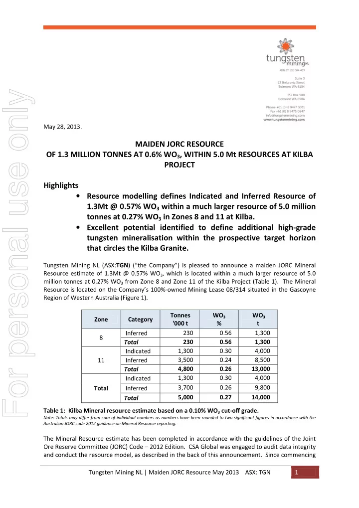
Tungsten Mining NL (ASX:TGN) (“the Company”) is pleased to announce a maiden JORC Mineral Resource estimate of 1.3Mt @ 0.57% WO3, which is located within a much larger resource of 5.0 million tonnes at 0.27% WO3 from Zone 8 and Zone 11 of the Kilba Project (Table 1). The Mineral Resource is located on the Company’s 100%-owned Mining Lease 08/314 situated in the Gascoyne Region of Western Australia (Figure 1). Zone Category Tonnes '000 t WO3 % WO3 t 8 Inferred 230 0.56 1,300 Total 230 0.56 1,300 11 Indicated 1,300 0.30 4,000 Inferred 3,500 0.24 8,500 Total 4,800 0.26 13,000 Total Indicated 1,300 0.30 4,000 Inferred 3,700 0.26 9,800 Total 5,000 0.27 14,000 Table 1: Kilba Mineral resource estimate based on a 0.10% WO3 cut-off grade.

Note: Totals may differ from sum of individual numbers as numbers have been rounded to two significant figures in accordance with the Australian JORC code 2012 guidance on Mineral Resource reporting.

The Mineral Resource estimate has been completed in accordance with the guidelines of the Joint Ore Reserve Committee (JORC) Code – 2012 Edition. CSA Global was engaged to audit data integrity and conduct the resource model, as described in the back of this announcement. Since commencing

For personal use only

slide-2
SLIDE 2

Tungsten Mining NL | Maiden JORC Resource May 2013 ASX: TGN 2 drilling in November 2012, the Company has drilled 24 diamond holes and 42 reverse circulation (“RC”) holes over 1200 metres of mineralised strike at Zone 11. Collar locations are displayed in Figure 2. Figure 1 – plan displaying location of Zone 8 and Zone 11 at the Kilba Project. Tungsten Mining Managing Director, Paul Berndt, said the release of a maiden JORC Mineral Resource represents a major step towards the Company achieving its objective of the rapid evaluation and development of the Kilba Project. “This milestone result provides us with confidence as we move to the feasibility study phase of the Kilba Project,” Mr Berndt said. “The higher-grade section of 1.3Mt @ 0.57% WO3 identified in this initial estimate, is a figure that meets our expectations, and importantly it is contained within a much larger resource of 5.0 million tonnes at 0.27% WO3, which provides us with significant upside potential. These results keep Tungsten Mining on target to fast-track Kilba into development in 2014.” Tungsten Mining’s recent activities have focused on Zone 11 where previous drilling by Union Carbide Corporation intersected high-grade tungsten mineralisation in the 1970s/1980s. Union Carbide’s work also defined significant mineralisation at Zone 8 and results from this historic drilling have been used in the Mineral Resource estimate. A range of lower cut-offs have been used to report grades and tonnages, as shown in Table 2 and Figure 3. This demonstrates that within the overall resource there are significant high-grade zones

  • f tungsten mineralisation.
  • M 08/314

E 08/2139

350,000 351,000 352,000 353,000 7,480,000 7,480,000 7,481,000 7,481,000

Kilba Project Summary May 2013

500 1,000 m

  • MINERAL RESOURCE
Outline DRILLING
  • TGN Holes
Union Carbide Hole TENEMENTS Exploration Licence Mining Lease LITHOLOGIES Skarn Calc-silicate Greisen Granite Morrisey Metamorphic Suite

Zone 11 Mineral Resource Coordinate - MGA Zone 50

Zone 8 Zone 11 Zone 9 Zone 12

Kilba

Proje c t e d c
  • n
tinuation
  • f
t a r g e t h
  • r
izon

Zone 8 Mineral Resource

For personal use only

slide-3
SLIDE 3

Tungsten Mining NL | Maiden JORC Resource May 2013 ASX: TGN 3 At Zone 11 tungsten mineralisation dips at 30 to 70 degrees toward the south to southwest and is associated with skarns and calc-silicate units. Typically high-grade mineralisation is associated with retrograde skarn units which are often surrounded by low to medium grade disseminated scheelite mineralisation in calc-silicate and sedimentary units. Toward the east of the prospect tungsten mineralisation tends to occur in a single high-grade zone, as shown in Figure 4. In the central and western domains mineralisation is associated with multiple shallow dipping low to medium-grade units, as shown by Figure 5. Union Carbide drilled diamond holes targeting high-grade tungsten mineralisation associated with skarns at Zone 8. Mineralisation dips steeply towards the north-northwest, as shown in Figure 6. A number of these holes have been used to estimate an Inferred Resource of 230,000 tonnes at 0.56%

  • WO3. Surface mapping has identified numerous skarn units at Zone 8 that have not been adequately

drill tested and future exploration will focus on evaluating these targets.

For personal use only

slide-4
SLIDE 4

Tungsten Mining NL | Maiden JORC Resource May 2013 ASX: TGN 4 Figure 2 – plan showing location of Mineral Resource outlines, TGN drilling, skarn outcrops and historic Union Carbide drill holes. The cross section “A – B”, “C – D” and “E – F” shown in blue are displayed in Figure 4, 5 and 6 below.

L 5 1 L L 5 7 1 5 5 1 7 1 5 7 1

  • 350,000

350,500 351,000 351,500 7,480,000 7,480,000 7,480,500 7,480,500 7,481,000 7,481,000

Kilba Project - Zone 8 and 11 Mineral Resource Estimate Tungsten Mining NL Gascoyne Region May 2013

250 500 750 m

  • LEGEND

MINERAL RESOURCE

Outline

SKARN UNITS

Outline

ALL DRILLING Grade_x_M

  • >0.10
  • 0.10 - 0.50
  • 0.50 - 1.00
  • 1.00 - 2.50
  • >2.50
  • Not Assayed

TOPOGRAPHY

5m contours

Zone 11 Resource Indicated 1,300,000 tonnes at 0.30% WO3 Inferred 3,500,000 tonnes at 0.24% WO3 Total 4,800,000 tonnes at 0.26% WO3 Zone 8 Resource Inferred 230,000 tonnes at 0.56% WO3 Zone12

Coordinates - MGA Zone 50

"A" "B" "C" "D" "E" "F"

For personal use only

slide-5
SLIDE 5

Tungsten Mining NL | Maiden JORC Resource May 2013 ASX:TGN 5 Cut Off W03 (%) Zone Class Tonnes '000 t WO3 % WO3 t 0.050 8 Inferred 230 0.56 1,300 Total 230 0.56 1,300 11 Indicated 1,600 0.27 4,200 Inferred 5,200 0.19 9,800 Total 6,800 0.21 14,000 Total Indicated 1,600 0.27 4,200 Inferred 5,400 0.20 11,000 Total 7,000 0.22 15,000 0.100 8 Inferred 230 0.56 1,300 Total 230 0.56 1,300 11 Indicated 1,300 0.30 4,000 Inferred 3,500 0.24 8,500 Total 4,800 0.26 13,000 Total Indicated 1,300 0.30 4,000 Inferred 3,700 0.26 9,800 Total 5,000 0.27 14,000 0.200 8 Inferred 200 0.61 1,200 Total 200 0.61 1,200 11 Indicated 790 0.41 3,200 Inferred 1,500 0.38 5,700 Total 2,300 0.39 8,900 Total Indicated 790 0.41 3,200 Inferred 1,700 0.40 7,000 Total 2,500 0.41 10,000 0.300 8 Inferred 160 0.72 1,100 Total 160 0.72 1,100 11 Indicated 450 0.53 2,400 Inferred 640 0.56 3,600 Total 1,100 0.55 6,000 Total Indicated 450 0.53 2,400 Inferred 800 0.59 4,700 Total 1,300 0.57 7,100 0.400 8 Inferred 160 0.73 1,100 Total 160 0.73 1,100 11 Indicated 280 0.64 1,800 Inferred 310 0.80 2,500 Total 590 0.72 4,300 Total Indicated 280 0.64 1,800 Inferred 460 0.77 3,600 Total 750 0.72 5,400 Table 2: Kilba Mineral Resource reported out at various lower cut-off grades.

Note: Totals may differ from sum of individual numbers as numbers have been rounded to two significant figures in accordance with the Australian JORC code 2012 guidance on Mineral Resource reporting.

For personal use only

slide-6
SLIDE 6

Tungsten Mining NL | Maiden JORC Resource May 2013 ASX:TGN 6 Figure 3 – Grade tonnage curve for Kilba Mineral Resource showing Indicated and Inferred tonnes and grade. Figure 4 – cross section showing block model and drilling for Zone 11 at the Eastern domain.

For personal use only

slide-7
SLIDE 7

Tungsten Mining NL | Maiden JORC Resource May 2013 ASX:TGN 7 Figure 5 – cross section showing block model and drilling for Zone 11 at the Western domain. Figure 6 – cross section showing block model and drilling for Zone 8.

For personal use only

slide-8
SLIDE 8

Tungsten Mining NL | Maiden JORC Resource May 2013 ASX:TGN 8 For further information contact Paul Berndt Managing Director Tel: +61 8 9477 3031 info@tungstenmining.com Colin Hay PPR Public Relations Tel: +61 8 9388 0944 colin.hay@ppr.com.au

Further information about the company's activities may be found at www.tungstenmining.com .

About Tungsten Mining: Tungsten Mining NL was admitted to ASX on 13 December, 2012. The Company is

focused on development and exploitation of tungsten deposits. The management and Board of the company have previous experience in tungsten mine development and operations . Tungsten is the right sector to be in, with sound fundamental drivers giving strong demand and firm pricing.

Competent Person’s Statement The information in this report that relates to Mineral Resources is based on information compiled by Serikjan Urbisinov, a Competent Person who is a Member of the Australian Institute of Geoscientists. Mr Urbisinov is not a full-time employee of the company. Mr Urbisinov is employed by the resource industry consultancy CSA Global Pty Ltd. Mr Urbisinov has sufficient experience that is relevant to the style of mineralisation and type of deposit under consideration and to the activity being undertaken to qualify as a Competent Person as defined in the 2012 Edition of the ‘Australasian Code for Reporting of Exploration Results, Mineral Resources and Ore Reserves’. Mr Urbisinov consents to the inclusion in the report of the matters based on his information in the form and context in which it appears. The information in this report that relates to Exploration Targets and Exploration Results is based on information compiled by Peter Bleakley, who is a Member of the Australasian Institute of Mining and

  • Metallurgy. Mr Bleakley is not a full-time employee of the company. Mr Bleakley is a consultant to

the mining industry. Mr Bleakley has sufficient experience that is relevant to the style of mineralisation and type of deposit under consideration and to the activity being undertaken to qualify as a Competent Person as defined in the 2012 Edition of the ‘Australasian Code for Reporting

  • f Exploration Results, Mineral Resources and Ore Reserves’. Mr Bleakley consents to the inclusion in

the report of the matters based on his information in the form and context in which it appears.

For personal use only

slide-9
SLIDE 9

Tungsten Mining NL | Error! No text of specified style in document. 9

JORC Code Reporting Criteria

Section 1 Sampling Techniques and Data

(Criteria in this section apply to all succeeding sections.)

Criteria JORC-Code Explanation Commentary

Sampling techniques Nature and quality of sampling (eg cut channels, random chips, or specific specialised industry standard measurement tools appropriate to the minerals under investigation, such as down hole gamma sondes, or handheld XRF instruments, etc). These examples should not be taken as limiting the broad meaning of sampling. The deposit is sampled using Reverse Circulation (RC), Diamond Drilling (DD) and trenches over several drilling campaigns. The latest drilling campaign was completed by Tungsten Mining utilising both RC and DD drilling. A total of 104 workings were completed in the area with the following breakdown: 5 historic trenches (350m), 32 historic diamond drillholes (2,656m), 24 Tungsten Mining diamond drillholes (2,807m) and 43 Tungsten Mining RC drillholes (4,355m). The majority of the holes were drilled at approximately 60⁰. Include reference to measures taken to ensure sample representivity and the appropriate calibration of any measurement tools or systems used. Tungsten Mining drillhole collar locations were picked-up by a licensed surveyor using a Topcon HiPer II RTK GPS. Downhole surveying was initially measured by the drill contractors using either a Reflex EZ-Shot Downhole Survey Instrument for DD holes or the Pathfinder survey instrument for RC drilling. Tungsten Mining completed additional downhole surveys on open holes using a gyroscopic probe. Approximately 80% of recent drilling has gyroscopic surveys. Certified standard and blanks samples were inserted into the sample sequences in according to Tungsten Mining QAQC procedures. Duplicate samples for RC and diamond samples were collected to check repeatability of sampling and variability

  • r nugget effect for tungsten mineralisation. Results from this QAQC sampling were

considered excellent. Aspects of the determination of mineralisation that are Material to the Public Report. In cases where ‘industry standard’ work has been done this would be relatively simple (eg ‘reverse circulation drilling was used to obtain 1 m samples from which 3 kg was pulverised to produce a 30 g charge for fire assay’). In other cases more explanation may be required, such as where there is coarse gold that has inherent sampling problems. Unusual commodities or mineralisation types (eg submarine nodules) may warrant disclosure of detailed information. The RC drilling crew collected 1 metre intervals from the cyclone and then riffle split the bulk sample to produce two representative 2 – 4 kilogram samples in calico

  • bags. The riffle splitter was cleaned by mechanical vibration and hosing with

pressurised air to eliminate sample contamination. One of the calico samples is for analysis and the second duplicate sample is retained as a reference sample for possible reanalysing / QAQC activities. For HQ diamond holes the mineralised and adjacent material was split using a diamond saw produce a half core sample. Sample intervals were defined by geological intervals and range from 0.3 – 1.2m. Core was orientated and the same side of the core was submitted for analysis. One half of the cut core is left in core boxes and retained in core storage. Sampling was extended 5 – 10 metres in both directions from mineralized zones. The core that is not sampled is kept uncut. Tungsten Mining samples were submitted to Ultra Trace Laboratories of Perth for analysis by XRF Tungsten and Molybdenum Ore -Extended Suite. Drilling techniques Drill type (eg core, reverse circulation, open- hole hammer, rotary air blast, auger, Bangka, sonic, etc) and details (eg core diameter, triple

  • r standard tube, depth of diamond tails, face-

sampling bit or other type, whether core is

  • riented and if so, by what method, etc).

32 historic NQ and BQ diamond drillholes were drilled in 3 campaigns from 1975 to 1981 by the previous operator (ANZECO). Holes ranged from 24 to 170 m, averaging 83 m. Tungsten Mining completed 24 diamond drillholes and 43 RC drillholes. RC holes depths ranged from 52 to 174 m, averaging 115 m. RC drilling used a face-sampling hammer that produced a nominal 140m diameter hole. Tungsten Mining diamond holes were HQ/HQ3 with the exception of 1 PQ metallurgical holes. Diamond holes were drilled from 55 to 179m, averaging 114m. Tungsten Mining diamond drill holes were surveyed at six metre intervals with a Reflex EZ-Shot Downhole Survey Instrument. RC holes were surveyed at 30 meter intervals using a Pathfinder survey instrument. Open holes were later surveyed utilizing a gyroscopic probe.

For personal use only

slide-10
SLIDE 10

Tungsten Mining NL | Error! No text of specified style in document. 10

Criteria JORC-Code Explanation Commentary

Drill sample recovery Method of recording and assessing core and chip sample recoveries and results assessed. Diamond core recovery is logged and recorded in the database. No significant core loss issue exists. The average core recovery is 99% and over 99% for the samples from the mineralised zones. RC recovery was visually assessed, recorded on drill logs and considered to be acceptable within the mineralized zones. Measures taken to maximise sample recovery and ensure representative nature of the samples. Diamond core was reconstructed into continuous runs for orientation marking, depths being checked against the depth marked on the core blocks. RC samples were visually checked for recovery, moisture and contamination. A cyclone and splitter were used to provide a uniform sample and these were routinely

  • cleaned. The drill contractor blew out the hole at the beginning of each drill rod to

remove excess water and maintain dry samples. Whether a relationship exists between sample recovery and grade and whether sample bias may have occurred due to preferential loss/gain

  • f fine/coarse material.

Sample Recovery for diamond holes is generally very high (over 99%) within the mineralised zones. Ground conditions for RC drilling were good and drilling returned consistent size samples. No significant bias is expected, and any potential bias is not considered material at this stage of resource development. Logging Whether core and chip samples have been geologically and geotechnically logged to a level of detail to support appropriate Mineral Resource estimation, mining studies and metallurgical studies. Tungsten Mining uses specially designed drill logs for skarn type deposits to capture the geological data. The modified log sheet lists percentages of various important skarn minerals. During logging part of the RC sample is washed, logged and placed into chip trays. The chip trays are stored in a designated building at site. Diamond core was geotechnically logged for recovery and RQD. Information on structure, lithology and alteration zones are recorded. Diamond core trays are stored on the site for future reference. All drill data is digitally captured and stored in a central database. Whether logging is qualitative or quantitative in nature. Core (or costean, channel, etc) photography. Diamond core and RC chips logging included records of lithology, mineralogy, textures, oxidation state and colour. Visual estimates of percentages of key minerals associated with tungsten mineralization and veining are made. Core was photographed in both daylight and UV light to estimate scheelite content. The total length and percentage of the relevant intersections logged. All drill holes were logged in full Sub-sampling techniques and sample preparation If core, whether cut or sawn and whether quarter, half or all core taken. All HQ diamond drill core was cut in half by an Almonte diamond saw. PQ metallurgical core was crushed to 10mm and riffle split. If non-core, whether riffled, tube sampled, rotary split, etc and whether sampled wet or dry. RC samples were collected on the rig using a cyclone and put through a riffle splitter to produce two 2 – 4 kg samples.. For all sample types, the nature, quality and appropriateness of the sample preparation technique. Samples were dried, crushed to 3mm using Boyd jaw crushers to achieve a nominal 90% passing – 3mm. Sieve check on 1 in 50 samples. After crushing and splitting the samples are sent for pulverisers to be ground to 75

  • microns. Grind check on 1 in 50 samples.

Quality control procedures adopted for all sub- sampling stages to maximise representivity of samples. Field QAQC procedures included the insertion of field duplicates, blanks and commercial standards. Standards were inserted at intervals of 30. If a duplicate or blank falls on the 30th sample, the standard sample number may be changed to suit. All laboratory QC data is reported within the structure of the final reports. A blank is included at the start of every job and then after every 90 samples. One duplicate and one CRM are included at random within each set of 24 analysed. One sample preparation split is performed in 25 samples. Wet sieving of at least one sample in every batch to confirm % -75um. Measures taken to ensure that the sampling is representative of the in situ material collected, including for instance results for field duplicate/second-half sampling. Approximately 1 in 30 RC field duplicates were taken from 1m riffle split samples at the rig. Repeatability in RC duplicate samples was found to be excellent. Approximately 1 in 11 half core samples were duplicated by quarter core samples. Repeatability of these samples was considered good, but demonstrated the particulate nature or nuggety of the scheelite mineralization.

For personal use only

slide-11
SLIDE 11

Tungsten Mining NL | Error! No text of specified style in document. 11

Criteria JORC-Code Explanation Commentary

Three diamond holes were drilled to twin RC drilling. These holes intersected similar zones of mineralization at target depths and again showed the particulate or nuggety nature of tungsten mineralization. Contained metal was similar. Whether sample sizes are appropriate to the grain size of the material being sampled. Sample sizes are considered to be appropriate to accurately represent the tungsten mineralisation at Kilba based on the thickness and consistency of the intersections, the sampling methodology and the percent value assay ranges for the primary elements. Quality of assay data and laboratory tests The nature, quality and appropriateness of the assaying and laboratory procedures used and whether the technique is considered partial or total. XRF has proven to be a very accurate analytical technique for a wide range of base metals, trace elements and major constituents found in rocks and mineral materials. Glass fusion XRF is utilised for assaying, since it provides good accuracy and precision; it is suitable for analysis from very low levels up to very high levels For geophysical tools, spectrometers, handheld XRF instruments, etc, the parameters used in determining the analysis including instrument make and model, reading times, calibrations factors applied and their derivation, etc. A handheld magnetic susceptibility meter (KT-10) was used to measure magnetic susceptibility for every sample. Data is stored in the database. Nature of quality control procedures adopted (eg standards, blanks, duplicates, external laboratory checks) and whether acceptable levels of accuracy (ie lack of bias) and precision have been established. Field QAQC procedures included the insertion of field duplicates, blanks and commercial standards. External laboratory checks were performed on samples from different rock types. Assay results have been generally satisfactory demonstrating acceptable levels of accuracy and precision. Verification

  • f

sampling and assaying The verification of significant intersections by either independent or alternative company personnel. Several independent personnel visually verified intersections in both diamond core and RC chips as well as in trenches and outcrops. UV lamping was used to visually estimate scheelite content. The use of twinned holes. RC holes that intercepted high grades zones were verified by closely drilled diamond holes. Documentation of primary data, data entry procedures, data verification, data storage (physical and electronic) protocols. Logging takes place at the drilling site. Panasonic Toughbook computers are used to record the logging. A set of standard Excel templates are used to capture the data. Data were then sent to CSA Global for validation and storage into a relational database. Discuss any adjustment to assay data. No adjustments were made, other than for values below the assay detection limit which have been entered as the negative of the detection limit Location of data points Accuracy and quality of surveys used to locate drill holes (collar and down-hole surveys), trenches, mine workings and other locations used in Mineral Resource estimation. Once each drillhole is drilled to the targeted depth, it is routinely downhole

  • surveyed. Downhole surveying was initially measured by the drill contractors using

either a Reflex EZ-Shot Downhole Survey Instrument for DD holes or the Pathfinder survey instrument for RC drilling. All drillholes had measurements covering the length of the hole with the reported accuracy of ±2 degrees. The instrument measures magnetic azimuth and dip. The correction for magnetic azimuth (0.8 degrees) is applied when the drillhole database is processed for resource estimation. Tungsten Mining completed additional downhole surveys on open holes using a gyroscopic probe. Due to hole blockages, only 80% of recent drilling has gyroscopic surveys with reported accuracy of ± 1.0 degrees for azimuth and ± 0.1 degrees for dip. All Tungsten Mining collar locations could be found easily and are clearly marked. Holes are initially picked up using a Carlson Surveyor + DGPG unit to sub-metre

  • accuracy. Periodically drillhole collar locations are picked-up by a licensed

surveyor using a Topcon HiPer II RTK GPS with an accuracy of +/- 10mm Horizontally and +/-15mm Vertically. In contrast, only limited number of historic drillholes can be located, since they were drilled over 30 years ago. Hole locations are estimated from drill plans, sections and located historic drill pads. Specification of the grid system used. The grid system is MGA_GDA94 Zone 50. Quality and adequacy of topographic control. AAM Pty Limited (AAM) was commissioned to fly aerial photography of the area in November of 2012 to obtain detailed topographic surface. AAM provided Tungsten Mining with a surface Digital Terrain Model (DTM) with 0.15 m vertical accuracy, 0.5 m contours and a 15 centimetre (cm) resolution digital orthophoto. All collar locations have been picked up by means of a Topcon HiPer II RTK GPS an accuracy of +/- 10mm Horizontally and +/-15mm Vertically. Data spacing and distribution Data spacing for reporting of Exploration Results. Drill holes were generally drilled using 80 x 40 m grid.

For personal use only

slide-12
SLIDE 12

Tungsten Mining NL | Error! No text of specified style in document. 12

Criteria JORC-Code Explanation Commentary

Whether the data spacing and distribution is sufficient to establish the degree of geological and grade continuity appropriate for the Mineral Resource and Ore Reserve estimation procedure(s) and classifications applied. The data spacing and distribution is sufficient to demonstrate spatial and grade continuity of the mineralised horizon to support the definition of Inferred/Indicated Mineral Resources under the 2012 JORC code. Whether sample compositing has been applied. 1 m samples were composited into 5m composite samples for RC. Any anomalous composite samples had the 1m riffle split samples submitted for analysis. Orientation of data in relation to geological structure Whether the orientation of sampling achieves unbiased sampling of possible structures and the extent to which this is known, considering the deposit type. The majority of drilling sections are approximately orientated North to South with respect to grid north. This orientation is perpendicular to the strike of the mineralised skarn units observed at Kilba. Holes are dominantly drilled at -60º towards skarn units to return intervals with thickness as true as possible. Diamond core observations confirmed that lithological units intersect drilling between 50 – 90 degrees to core axis. If the relationship between the drilling

  • rientation

and the

  • rientation
  • f

key mineralised structures is considered to have introduced a sampling bias, this should be assessed and reported if material. Diamond drilling confirmed that drilling orientation did not introduce any bias regarding the orientation of the skarn units. Sample security The measures taken to ensure sample security. All sample numbers are generated in the site office. Once samples intervals are selected, the numbers are assigned to each sample. The sample numbers are not left in the core box (where the sample was taken from), but the core is marked for the taken sample intervals so it would be possible to reconcile the laboratory results against the particular intervals of core. The sample number, drillhole name and sampled interval are recorded in the sampling sheets. All sample bags are properly sealed and transported to Nanutarra roadhouse where they are couriered by Toll IPEC to the Ultra Trace laboratory in Perth Audits or reviews The results of any audits or reviews of sampling techniques and data. Sampling techniques are consistent with industry standards. Consistency of data was validated by CSA Global while loading into the database (Depth from < Depth to; interval is within hole depth, check for overlapping samples or intervals, etc.). Any data which fails the database constraints and cannot be loaded is returned to Tungsten Mining for validation, etc.). Global consistency was also checked later on by plotting sections using the database and reconciling assays. Section 2 Reporting of Exploration Results (Criteria listed in the preceding section also apply to this section.) Criteria JORC-Code Explanation Commentary Mineral tenement and land tenure status Type, reference name/number, location and

  • wnership including agreements or material

issues with third parties such as joint ventures, partnerships, overriding royalties, native title interests, historical sites, wilderness or national park and environmental settings. Kilba prospect comprises one Mining Lease and one Exploration License covering an area of approximately 35 km2 (3,548 hectares). Current registered holders of the tenements are SM3-W Pty Ltd and BRL Exploration Pty Ltd. The Buurabalayji Thalanyji Aboriginal Corporation is entitled to a production fee of 0.75% plus GST of the sale price realised by the tenement holder for all minerals or commodities recovered and sold. The normal Western Australian state royalties apply. Tungsten Mining has 100% interest in all tenements. The prospect has a current expenditure commitment of $90,500 per reporting year. The security of the tenure held at the time of reporting along with any known impediments to

  • btaining a licence to operate in the area.

The tenement is in good standing Exploration done by other parties Acknowledgment and appraisal of exploration by

  • ther parties.

There are 32 historic drillholes and 5 trenches in the area that were drilled in 3 campaigns from 1975 till 1981 by the previous operator (ANZECO / Union Carbide).

For personal use only

slide-13
SLIDE 13

Tungsten Mining NL | Error! No text of specified style in document. 13

Criteria JORC-Code Explanation Commentary Geology Deposit type, geological setting and style of mineralisation. Mineralization is associated with scheelite tungsten skarns The mineralogy of the Kilba skarns consist dominantly of wollastonite, grossularite garnet (Ca, up to mole 97% grossular component), and pyroxene intermediate in composition between diopside and hedenbergite (salite). This assemblage is altered to dark green to black amphiboles (dominantly actinolite to ferroactinolite), vesuvianite, epidote and clinozoisite. This garnet mineralogy is most typical of oxidised rather than reduced skarns (i.e. oxidised ore fluids). Higher temperature prograde and lower-temperature retrograde assemblages can be

  • recognized. Most scheelite is reportedly associated with the retrograde assemblage

Drill hole Information A summary of all information material to the understanding of the exploration results including a tabulation of the following information for all Material drill holes: In the company’s opinion this material has been adequately reported in previous announcements and the detail is not relevant for reporting of Mineral Resources

  • easting and northing of the drill hole

collar

  • elevation or RL (Reduced Level –

elevation above sea level in metres) of the drill hole collar

  • dip and azimuth of the hole
  • down hole length and interception depth
  • hole length.

If the exclusion of this information is justified on the basis that the information is not Material and this exclusion does not detract from the understanding of the report, the Competent Person should clearly explain why this is the case. Data aggregation methods In reporting Exploration Results, weighting averaging techniques, maximum and/or minimum grade truncations (eg cutting of high grades) and cut-off grades are usually Material and should be stated. Not reporting exploration results. Where aggregate intercepts incorporate short lengths of high grade results and longer lengths of low grade results, the procedure used for such aggregation should be stated and some typical examples of such aggregations should be shown in detail. Not applicable. The assumptions used for any reporting of metal equivalent values should be clearly stated. Not applicable. Relationship between mineralisation widths and intercept lengths These relationships are particularly important in the reporting of Exploration Results. Drill hole angles of -60° toward the Northeast are adequate to drill mineralised skarn units If the geometry of the mineralisation with respect to the drill hole angle is known, its nature should be reported. Not reporting exploration results. If it is not known and only the down hole lengths are reported, there should be a clear statement to this effect (eg ‘down hole length, true width not known’). Not reporting exploration results. Diagrams Appropriate maps and sections (with scales) and tabulations of intercepts should be included for any significant discovery being reported These should include, but not be limited to a plan view of drill hole collar locations and appropriate sectional views. Refer to diagrams in body of text Balanced reporting Where comprehensive reporting of all Exploration Results is not practicable, representative reporting

  • f both low and high grades and/or widths should

be practiced to avoid misleading reporting of Exploration Results. Not reporting exploration results

For personal use only

slide-14
SLIDE 14

Tungsten Mining NL | Error! No text of specified style in document. 14

Criteria JORC-Code Explanation Commentary Other substantive exploration data Other exploration data, if meaningful and material, should be reported including (but not limited to): geological observations; geophysical survey results; geochemical survey results; bulk samples – size and method of treatment; metallurgical test results; bulk density, groundwater, geotechnical and rock characteristics; potential deleterious

  • r

contaminating substances. In the company’s opinion this material has been adequately reported in previous announcements and the detail is not relevant for reporting of Mineral Resources Further work The nature and scale of planned further work (eg tests for lateral extensions or depth extensions or large-scale step-out drilling). Drilling is planned to upgrade the resources and check the extent of the mineralised zones. Diagrams clearly highlighting the areas of possible extensions, including the main geological interpretations and future drilling areas, provided this information is not commercially sensitive. Not applicable.

Section 3 Estimation and Reporting of Mineral Resources

(Criteria listed in section 1, and where relevant in section 2, also apply to this section.)

Criteria JORC-Code Explanation Commentary

Database integrity Measures taken to ensure that data has not been corrupted by, for example, transcription or keying errors, between its initial collection and its use for Mineral Resource estimation purposes. Data used in the Mineral Resource estimate is sourced from a database dump, provided in the form of an MS Access database, from the Datashed relational database hosted by CSA Global. Relevant tables from the data base are exported to Micromine dat format for import into Micromine 2011 software for use in the Mineral Resource estimate. Validation protocols for the data entered to the Datashed database are described in Section 1 Data validation procedures used. Validation of the data import include checks for overlapping intervals, missing survey data, missing and incorrectly recorded assay data, missing lithological data and missing collars. Site visits Comment on any site visits undertaken by the Competent Person and the outcome of those visits. Serikjan Urbisinov, Principal Resource Geologist for CSA Global Pty Ltd, conducted a site visit to the Kilba project area in March 2013. A site visit report was compiled and attached the resource estimation report. If no site visits have been undertaken indicate why this is the case. Not applicable Geological interpretation Confidence in (or conversely, the uncertainty of ) the geological interpretation of the mineral deposit. There is a reasonable level of confidence in the geological interpretation of scheelite skarn that is traceable over numerous drill holes and drill sections and in surface mapping of the outcrops and trench exposures. Additional work is required to better define exact geometry and the extents of the interpreted mineralised skarn. Further work is also needed to better define the mineralogical control of the scheelite content. Any additional work is expected to have a reasonable prospect of increasing the interpreted total mineralised volumes in the tenement as significant areas that have not yet been drill tested along the granitic intrusion contact. Nature of the data used and of any assumptions made. Surface mapping of mineralised outcrop, drill hole intercept logging and assay results have formed basis for the geological interpretation. The effect, if any, of alternative interpretations on Mineral Resource estimation. The precise limits and geometry cannot be absolutely defined due to the limitations

  • f the current drill coverage. Further work is required to better define the geometry

and limits of the mineralised skarn zones, but no significant downside changes to the interpreted mineralised volume are anticipated. The use of geology in guiding and controlling Mineral Resource estimation. The grade and lithological interpretation forms the basis for the modelling. Lithological envelopes defining the prospective skarns within which the grade estimation has been completed. The factors affecting continuity both of grade and geology. Contact metamorphism, skarn alteration and tungsten mineralisation are also linked to the intrusion of the Kilba granite. The continuity of the mineralised zones is closely relate to the contact with the central monzogranite stock that has a form of an elliptical dome. The scheelite content depends on the type of skarn present. Most scheelite is reportedly associated with the retrograde assemblage.

For personal use only

slide-15
SLIDE 15

Tungsten Mining NL | Error! No text of specified style in document. 15

Criteria JORC-Code Explanation Commentary

Dimensions The extent and variability of the Mineral Resource expressed as length (along strike or

  • therwise), plan width, and depth below surface

to the upper and lower limits of the Mineral Resource. The currently interpreted skarns of zone 11 extend for approximately 1.4 km along 300° NW strike. The width of the zone 11 varies from 2m to 40m with maximum 10m thickness for individual mineralised envelopes. The dip angle of the zone varies from

  • 60 degrees at the eastern side to -25 degrees on the western side. The zone extends

from the surface to the 150m below the surface. Skarns of zone 8 extend for approximately 150 m at 52° NE direction and dip at -70

  • degrees. The maximal depth here is approximately 70m below surface.

Estimation and modelling techniques The nature and appropriateness of the estimation technique(s) applied and key assumptions, including treatment of extreme grade values, domaining, interpolation parameters and maximum distance of extrapolation from data

  • points. If a computer assisted estimation method

was chosen include a description of computer software and parameters used. CSA made a decision that the model and sample composite files should be unfolded before geostatistical analysis and grade interpolation. Without unfolding the deposit would have to be domained according to the general dipping of different parts of the

  • structures. In that case every structural domain would have to be estimated

separately, and that would downgrade the reliability of the estimate. Grade estimation was by Multiple Indicator Kriging (MIK) using Micromine 2011

  • software. The interpretation was extended perpendicular to the corresponding first

and last interpreted cross section to the distance equal to a half distance between the adjacent exploration lines which is approximately 40m; If a mineralised envelope did not extend to the adjacent drillhole section, it was projected half way to the next section and terminated. The general direction and dip

  • f the envelopes was maintained.

The availability of check estimates, previous estimates and/or mine production records and whether the Mineral Resource estimate takes appropriate account of such data. No previous estimates have been completed for this deposit, and no mining has taken place. The MIK estimate was completed concurrently with two check Inverse Distance Weighting (IDW) estimates. The MIK estimate used the parameters obtained from the modelled variograms. The results of the check estimates correlate well. The assumptions made regarding recovery of by- products. No assumption have been made. Estimation of deleterious elements or other non- grade variables of economic significance (eg sulphur for acid mine drainage characterisation). No other elements were estimated In the case of block model interpolation, the block size in relation to the average sample spacing and the search employed. The block model was constructed using a 20mE x 10mN x 10mRL parent block size, with subcelling to 2mE x 1mN x 1mRL for domain volume resolution. The parent cell size was chosen on the basis of the general morphology of mineralised bodies and in

  • rder to avoid the generation of too large block models. The subcelling size was

chosen to maintain the resolution of the mineralised bodies. The subcells were

  • ptimised in the models where possible to form larger cells.

The search radii were determined by means of the evaluation of the semivariogram parameters, which determined the kriging weights to be applied to samples at specified distances. The first search radii for all lodes were selected to be equal to two thirds of the semivariogram long ranges in all directions. Model cells that did not receive a grade estimate from the first interpolation run were used in the next interpolation with greater search radii equal to full long semivariogram ranges in all directions. The model cells that did not receive grades from the first two runs were then estimated using radii incremented by the full long semivariogram ranges. When model cells were estimated using radii not exceeding the full semivariogram ranges, a restriction of at least three samples from at least two drillholes was applied to increase the reliability of the estimates. Any assumptions behind modelling of selective mining units. No selective mining units were assumed in this estimate Any assumptions about correlation between variables. No strong correlations were found between the grade variables Description of how the geological interpretation was used to control the resource estimates. The 0.025% WO3 grade envelopes were defined. Hard boundaries between the grade envelopes used to select sample populations for grade estimation. Discussion of basis for using or not using grade cutting or capping. No grade cutting was applied, because MIK was used for the grade interpolation. The last bin defined for MIK is likely to contain occasional very high values, the estimate for this bin only is calculated using the median, which gives a more conservative value for positively skewed data than the mean. The process of validation, the checking process used, the comparison of model data to drill hole data, and use of reconciliation data if available. Validation of the block model consisted of comparison of the block model volume to the wireframe volume. Grade estimates were validated by statistical comparison with the drill data, visual comparison of grade trends in the model with the drill data

  • trends. No reconciliation data is available at this early stage of the project.

For personal use only

slide-16
SLIDE 16

Tungsten Mining NL | Error! No text of specified style in document. 16

Criteria JORC-Code Explanation Commentary

Moisture Whether the tonnages are estimated on a dry basis or with natural moisture, and the method of determination of the moisture content. The tonnages are estimated on a dry basis Cut-off parameters The basis of the adopted cut-off grade(s) or quality parameters applied. Statistical analysis showed natural breaks in the WO3 grade population distribution at approximately 0.025% which formed the basis for the decision regarding determination of mineralisation envelope cut-off grade. The Mineral Resource is quoted from estimated blocks above this cut-off grade. Mining factors or assumptions Assumptions made regarding possible mining methods, minimum mining dimensions and internal (or, if applicable, external) mining

  • dilution. It is always necessary as part of the

process of determining reasonable prospects for eventual economic extraction to consider potential mining methods, but the assumptions made regarding mining methods and parameters when estimating Mineral Resources may not always be rigorous. Where this is the case, this should be reported with an explanation of the basis of the mining assumptions made. The potential resource development scenario is based on open pit mining methods. It has been assumed that the full explored strike length, width and depth of the modelled mineralisation can be economically mined. To test this assumption a preliminary pit design using average 55⁰ pit walls slopes was modeled and gave a stripping ratio of 5.6:1. Metallurgical factors or assumptions The basis for assumptions or predictions regarding metallurgical amenability. It is always necessary as part of the process of determining reasonable prospects for eventual economic extraction to consider potential metallurgical methods, but the assumptions regarding metallurgical treatment processes and parameters made when reporting Mineral Resources may not always be rigorous. Where this is the case, this should be reported with an explanation of the basis of the metallurgical assumptions made. Metallurgical testwork is currently being conducted on PQ core to indicate the percentage recovery of tungsten, liberation sizes and potential concentrate grade. Environmental factors or assumptions Assumptions made regarding possible waste and process residue disposal options. It is always necessary as part of the process of determining reasonable prospects for eventual economic extraction to consider the potential environmental impacts of the mining and processing operation. While at this stage the determination of potential environmental impacts, particularly for a greenfields project, may not always be well advanced, the status of early consideration of these potential environmental impacts should be

  • reported. Where these aspects have not been

considered this should be reported with an explanation of the environmental assumptions made. No detailed assumption regarding possible waste and process residue disposal

  • ptions have been made at this stage. Some environmental surveys across the project

area encompassing sites of potential mining activities and related infrastructure have been completed and to date no significant issues have been identified. Heritage clearance surveys have been completed prior to each round of drilling and no heritage site as defined by Section 5 of the Aboriginal Heritage Act 1972 was identified during any of the surveys. Bulk density Whether assumed or determined. If assumed, the basis for the assumptions. If determined, the method used, whether wet or dry, the frequency of the measurements, the nature, size and representativeness of the samples. Bulk density measurement were collected every metre where possible using the following simple buoyancy method: For competent core the dry bulk density is calculated as the mass of sample in air divided by the difference between the mass of the sample in air and the mass of the sample in water. The bulk density for bulk material must have been measured by methods that adequately account for void spaces (vugs, porosity, etc), moisture and differences between rock and alteration zones within the deposit. Some porosity can be expected however the bulk density assigned is considered to be reasonable. Discuss assumptions for bulk density estimates used in the evaluation process of the different materials. The same bulk density has been applied to all material in the model.

For personal use only

slide-17
SLIDE 17

Tungsten Mining NL | Error! No text of specified style in document. 17

Criteria JORC-Code Explanation Commentary

Classification The basis for the classification of the Mineral Resources into varying confidence categories. The Inferred Mineral Resource classification is based on the evidence from the available drill sampling and surface mapping. This evidence is sufficient to imply but not verify geological and grade continuity. However, the areas with the denser drilling and robust continuation of the mineralised zones were classified as Indicated Mineral Resource Whether appropriate account has been taken of all relevant factors (ie relative confidence in tonnage/grade estimations, reliability of input data, confidence in continuity of geology and metal values, quality, quantity and distribution of the data). The Inferred and Indicated classification has taken into account all available geological and sampling information, and the classification level is considered appropriate for the current stage of this project. Whether the result appropriately reflects the Competent Person’s view of the deposit. The Mineral Resource estimate appropriately reflects the view of the Competent Person. Audits or reviews. The results of any audits or reviews of Mineral Resource estimates. No audits of the Mineral Resource estimate have been undertaken at this time Discussion of relative accuracy/ confidence Where appropriate a statement of the relative accuracy and confidence level in the Mineral Resource estimate using an approach or procedure deemed appropriate by the Competent Person. For example, the application

  • f

statistical or geostatistical procedures to quantify the relative accuracy of the resource within stated confidence limits, or, if such an approach is not deemed appropriate, a qualitative discussion of the factors that could affect the relative accuracy and confidence of the estimate. The relative accuracy of the Mineral Resource estimate is reflected in the reporting

  • f the Mineral Resource to an Inferred and Indicated classification as per the

guidelines of the 2012 JORC Code The statement should specify whether it relates to global or local estimates, and, if local, state the relevant tonnages, which should be relevant to technical and economic evaluation. Documentation should include assumptions made and the procedures used. The statement refers to global estimation of tonnes and grade These statements of relative accuracy and confidence of the estimate should be compared with production data, where available. No production data is available

For personal use only