flood vulnerability assessment contributions of the
play

Flood Vulnerability Assessment: Contributions of the - PDF document

Flood Vulnerability Assessment: Contributions of the Bogardi/Birkmann/Cardona (BBC) framework Zeinab Rezaee Ardestani, Pete Fisher, Heiko Balzter Department of Geography, University of Leicester, Leicester, England, LE1 7RH Email: zr12@le.ac.uk,


  1. Flood Vulnerability Assessment: Contributions of the Bogardi/Birkmann/Cardona (BBC) framework Zeinab Rezaee Ardestani, Pete Fisher, Heiko Balzter Department of Geography, University of Leicester, Leicester, England, LE1 7RH Email: zr12@le.ac.uk, pff1@le.ac.uk, hb91@le.ac.uk Summary: Understanding the pattern of vulnerability in a community plays a fundamental role in emergency management. Place-based vulnerability assessment is a way to evaluate vulnerability that takes into account the bio-physical and socio-economic characteristics of the target groups within the study area (Cutter 1996). However, there are gaps in terms of a holistic framework that constitutes diverse aspects of vulnerability. The aim of this study is to implement the BBC conceptual framework (Bogardi, Birkmann 2004, Cardona 2001, Cardona 1999) for vulnerability assessment in the context of England in order to propose an appropriate Vulnerability Index (BBC-VI) and methodology that reduce the vulnerability and ensure sustainable development. KEYWORDS: Vulnerability assessment, Place-based vulnerability, BBC conceptual framework, Flooding, Yorkshire (UK)
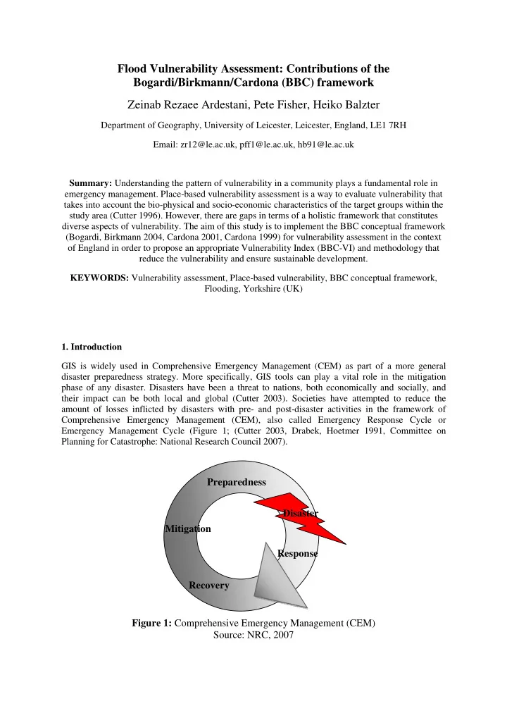
 1. Introduction GIS is widely used in Comprehensive Emergency Management (CEM) as part of a more general disaster preparedness strategy. More specifically, GIS tools can play a vital role in the mitigation phase of any disaster. Disasters have been a threat to nations, both economically and socially, and their impact can be both local and global (Cutter 2003). Societies have attempted to reduce the amount of losses inflicted by disasters with pre- and post-disaster activities in the framework of Comprehensive Emergency Management (CEM), also called Emergency Response Cycle or Emergency Management Cycle (Figure 1; (Cutter 2003, Drabek, Hoetmer 1991, Committee on Planning for Catastrophe: National Research Council 2007). Preparedness Disaster Mitigation Response Recovery Figure 1: Comprehensive Emergency Management (CEM) Source: NRC, 2007

  2. In the light of CEM, mitigation has been viewed as a phase in which GIS is most effective, where vulnerability and risk management are interesting parts for scientific work. However, there are multiple definitions of vulnerability and researchers have developed bespoke definitions (Green 2004, Cutter, Mitchell & Scott 2000). There are three general origins of vulnerability: • Physical vulnerability focuses on the nature of the bio-physical hazard; • Social aspects of vulnerability characterises the population at risk, their coping capacity, and resilience to hazard; and • Place-based methods are a third group which combine the social and physical approaches. Place-based vulnerability assessment further includes frameworks as follows: the Double structure framework defines two aspects of vulnerability; internal and external (Bohle 2001). The framework of hazard and risk community views vulnerability as a component of hazard and background risk where risk is defined through hazard, exposure, vulnerability, external context, emergency response, and emergency recovery capacity (Davidson 1997, Gabor, Griffith 1980). The global environmental change community focuses on vulnerability as a broader concept characterizing vulnerability with exposure, sensitivity, and resilience within a human-environmental system (Liverman 1990, Turner et al. 2003). The political economy approach describes the disaster as a hazard event that influences vulnerable people (Wisner et al. 2004). The Pressure And Release (PAR) method has been widely = Risk R H E V E (Blaikie et al. 2004). The holistic ( ( ). ( )) utilized in this framework, where h v approach to risk and vulnerability assessment defines a broad dynamic system that takes into account complex parameters (Cardona 2003). The BBC conceptual framework is based on the work of Bogardi and Birkmann (2004) and Cardona (1999, 2001). This framework borrows elements from other schools of thinking and focuses on the concept of sustainable development with exposed and susceptible elements and coping capacity where vulnerability is a process and should be examined from social, economic, and environmental aspects (Figure 2). Vulnerability assessment is sensitive to the type of hazard and the region of study, and so defining these is the first step for analysis. Floods are the most common type of natural disaster with nearly half the reported disasters in 2010 being from this cause (Centre for Research on the Epidemiology of Disasters - CRED 2009). This is as true for Europe and the UK, as much as for the rest of the world. Here floods cause the greatest loss (economic, physical, and social). Flooding has been the main cause of human and economic damage in the UK in past decades (Centre for Research on the Epidemiology of Disasters - CRED 2009). To explore the BBC method more fully, we focussed on flooding in Yorkshire, UK. 2. Methodology The BBC framework is simple to understand, and complex enough to capture the reality of vulnerability. The BBC conceptual framework is summarised in Figure 2 (Birkmann 2006). This model is based on the view that vulnerability goes beyond damage assessment, towards a dynamic process that continuously evaluates vulnerability as a combination of social, environmental, and economic aspects and links them to risk reduction and sustainable development (Green, Parker & Tunstall 2000). In the BBC model it is argued that there are two opportunities for vulnerability reduction. One before the disaster strikes (t=0) which is closely related to concepts of preparedness and mitigation in CEM, and one after and during disaster (t=1), the main phase of disaster management. The BBC framework

  3. makes the potential to reduce vulnerability and risk with intervention systems such as land use policies, which is an important distinctive priority of this model compared to others. Infrastructure arrangements are important in risk reduction; however, their effectiveness greatly depends on the implementation capacity (Katsuhama, Grigg 2010). In this context vulnerability is viewed as a combined concept of coping capacity and exposed/ susceptible elements. Figure 2: The BBC conceptual framework (Source: Birkmann, 2006: 34) 3. Experimental Analysis For Yorkshire, basic socio-economic data at OA level were downloaded from the CASWEB website (Table 1). These indicators have been suggested by Cutter et al (2000) as a broad experimental socio- economic vulnerability index. For each of the three characteristics; population and structure, differential access to resources, and level of physical vulnerability and wealth, some indicators have been put forward that can represent them. However, this table can be a matter of discussion as many specialists have proposed various indicators. Table 1: List of social vulnerability indicators proposed by Cutter et al. (2000) Social Vulnerability Indicators Characteristics Variable Population and structure Population Number of homes Differential access to resources Number of females Number of non-white residents Number of people under age 18 Number of people above age 65 Level of physical vulnerability and wealth Number of mobile homes Average household size

  4. Figure 3: Composite social vulnerability zones in Yorkshire Figure 4: Biophysical hazard of flooding presented by 2 type of flood zones Source: The Environment Agency

  5. To extract a social vulnerability index, all the variables were standardize by first determining the ratio of the variable in each OA to the total in the study area for that variable, and dividing that by the maximum of the ratio to generate an index for each variable ranging from 0 to 1, where the higher value relates to greater vulnerability. These indices were summed to give an overall vulnerability for each OA. Since there is not a common weighting scheme for indicators in the literature, no priority was given to any variable, assuming they have equal influence on the vulnerability. Figure 3 maps the social vulnerability. For the physical vulnerability map, flood zone data were provided by the Environment Agency, and used here (Figure 5): • Flood zone 2: chance of flooding in any year is greater than 0.1% and less than 1%. • Flood zone 3: chance of flooding in any year is greater than 1%. Here we assume a Boolean physical vulnerability: ���� � �0 �� �� ���� ��� ��������� ���� ����� ���� 2 �� 3 1 �� �� ��������� ���� ����� ���� 2 �� 3 The resulting map is used as a mask for social vulnerability as a data layer in order to extract the final vulnerability index. As there is no solid literature about the relative of importance of either social or biophysical aspects of vulnerability, no priority was given to either. Figure 5: Place-based vulnerability index in Yorkshire.

Download Presentation
Download Policy: The content available on the website is offered to you 'AS IS' for your personal information and use only. It cannot be commercialized, licensed, or distributed on other websites without prior consent from the author. To download a presentation, simply click this link. If you encounter any difficulties during the download process, it's possible that the publisher has removed the file from their server.

Recommend


More recommend