Flood: 2007 Flood: 2007 Madhubani District Madhubani District - - PowerPoint PPT Presentation

flood 2007 flood 2007
SMART_READER_LITE
LIVE PREVIEW

Flood: 2007 Flood: 2007 Madhubani District Madhubani District - - PowerPoint PPT Presentation

Flood: 2007 Flood: 2007 Madhubani District Madhubani District ON WE WORK ON WE WORK ..Disaster Management, ..Disaster Management, Madhubani Madhubani th Sep. 2007 All Figure As on 05 th 1 All Figure As on 05 Sep. 2007


slide-1
SLIDE 1

1

Flood: 2007 Flood: 2007

Madhubani District Madhubani District

ON WE WORK ON WE WORK

……..Disaster Management, ……..Disaster Management, Madhubani Madhubani

All Figure As on 05 All Figure As on 05th

th Sep. 2007

  • Sep. 2007
slide-2
SLIDE 2

2

Profile of Madhubani District Profile of Madhubani District

  • Sl.

No.

Parameter As per the census of year 2001

Total Rural Urban 1

Population :

Persons

3575281 3450736 124545

Males

1840997 1775203 65794

Females

1734284 1675533 58751

2 Decadal growth rate :

26.24

3 Density :

1021

4 Sex ratio (Total Population) :

942 944 893

5 Sex ratio ( 0 - 6 Population) :

939 940 924

6 Percentage of 0-6 Population : Persons

20.31 20.41 17.44

7 Percentage of Urban Population :

3.48

8 Literacy rate : Persons

41.97 41.18 63.10

slide-3
SLIDE 3

3

  • District Boundary

District Boundary-

  • North

North

  • NEPAL

NEPAL

  • South

South

  • Darbhanga District

Darbhanga District

  • East

East

  • Supaul District

Supaul District

  • West

West

  • Sitamarhi District

Sitamarhi District

  • General Information

General Information-

  • Number of Villages

Number of Villages

  • 1116

1116

  • Number of Panchayats

Number of Panchayats

  • 399

399

  • Number of C.D.Blocks

Number of C.D.Blocks

  • 21

21

  • Number of Revenue Circles

Number of Revenue Circles

  • 20

20

  • Number of Sub

Number of Sub-Divisions Divisions

  • 05

05

  • Number of Urban Area Bodies

Number of Urban Area Bodies

  • 04

04

  • Number of M.P. Constituencies

Number of M.P. Constituencies

  • 02

02

  • Number of M.L.A. Constituencies

Number of M.L.A. Constituencies

  • 11

11

  • Number of Zila Parishad Members

Number of Zila Parishad Members - 56 56

Profile of Madhubani District Profile of Madhubani District

slide-4
SLIDE 4

4

Geographical Information Geographical Information-

  • Longitude

Longitude

  • 250 9’21’’ to 260 39’1’’ East

250 9’21’’ to 260 39’1’’ East

  • Latitude

Latitude

  • 850 42’50’’ to 860 41’5’’ North

850 42’50’’ to 860 41’5’’ North

  • Total Area

Total Area

  • 873524 Acres

873524 Acres

  • Nature of Soil

Nature of Soil

  • Clay, Sandy & Salty

Clay, Sandy & Salty

  • Maximum Temperature

Maximum Temperature

  • 43.30

43.30o C. C.

  • Minimum Temperature

Minimum Temperature

  • 20

200 C. C.

  • Height from Sea

Height from Sea

  • 80 Meter

80 Meter

  • Average Rain fall Yearly

Average Rain fall Yearly

  • 900

900-1200 MM 1200 MM

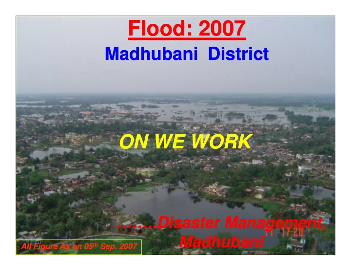
Threats of the District Threats of the District-

  • Natural Disaster

Natural Disaster- Flood Zone, High Risk Flood Zone, High Risk- Seismic Zone V, Cold Wave, High Seismic Zone V, Cold Wave, High Wind, Drought & Fire Wind, Drought & Fire.

  • Population Explosion

Population Explosion– The growth rate is a grave Concern for the district. The growth rate is a grave Concern for the district.

  • Volatile International Border

Volatile International Border– Keeping in the Maoist activities in NEPAL. Keeping in the Maoist activities in NEPAL.

  • Migration of Work Force

Migration of Work Force to the other area thereby reducing available work to the other area thereby reducing available work force at the local level. force at the local level.

  • Under Developed Infrastructure

Under Developed Infrastructure

  • Low Agriculture Production

Low Agriculture Production

  • Illiteracy

Illiteracy

Profile of Madhubani District Profile of Madhubani District

slide-5
SLIDE 5

5

Genesis of Calamity: 2007 Genesis of Calamity: 2007

  • Heavy Rains in the western part:

Heavy Rains in the western part:

  • Total Rainfall of Present weather

Total Rainfall of Present weather- 1301.06 MM 1301.06 MM

  • Sl. No.
  • Sl. No.

Name of Circle Name of Circle Actual Rainfall in month Actual Rainfall in month June June July July Aug. Aug.

  • !

!

  • "

"

  • #

#

  • "

"

  • #$

#$

  • %

%

  • %$!

%$!

  • &

&

  • ''

''

  • (

(

  • $

$

  • "

"

  • )!

)!

  • &

&

  • Normal Average

Normal Average Rain Fall Of District Rain Fall Of District June June : 213.6 : 213.6 July July : 333.6 : 333.6 Aug. Aug. : 293.9 : 293.9 Sep. Sep. : 238.6 : 238.6 Actual Average of Actual Average of Rainfall 2007 Rainfall 2007 June June : 310.6 : 310.6 July July : 518.8 : 518.8 Aug. Aug. : 448.8 : 448.8

slide-6
SLIDE 6

6

  • Breaches in Embankment on rivers in the Eastern Part

Breaches in Embankment on rivers in the Eastern Part

Genesis of Calamity: 2007 Genesis of Calamity: 2007

Sl. Sl. No. No. Name of Name of River River Name of Embankment Name of Embankment Name of Name of Block Block Date of Date of Breach Breach 1. 1. Bhutahi Bhutahi Balan Balan Right Embankment at Right Embankment at 25.0 Km 25.0 Km Phulparas Phulparas 26.07.2007 26.07.2007 2. 2. Kamala Kamala Balan Balan Right Embankment at Right Embankment at 47.8 Km 47.8 Km Jhanjharpur Jhanjharpur 27.07.2007 27.07.2007 3. 3. Khiroie Khiroie Right Embankment at Right Embankment at 12.50 Km 12.50 Km Benipatti Benipatti 26.07.2007 26.07.2007

  • Nature of Calamity:

Nature of Calamity: Flood Flood

  • Reason of Occurrence =

Reason of Occurrence = Heavy Rain + Breaches in Embankment Heavy Rain + Breaches in Embankment

slide-7
SLIDE 7

7

The Devastation The Devastation

# Dislocation of population from its habitat. # Dislocation of population from its habitat. # At other locations, houses surrounded by accumulated # At other locations, houses surrounded by accumulated water water # Destruction of Roads at Several Places. # Destruction of Roads at Several Places. # Employment Pattern Disrupted. # Employment Pattern Disrupted. # Immediate rise in Prices of Essential goods. # Immediate rise in Prices of Essential goods.

  • Total Circles Affected

Total Circles Affected : 20 : 20

  • Total Panchayats affected

Total Panchayats affected : 328 : 328 – Total villages affected Total villages affected : 827 : 827 – Population affected Population affected : 17.26301 Lakh : 17.26301 Lakh – No. of Families affected

  • No. of Families affected

: 3.57715 Lakh : 3.57715 Lakh – Human Lives Lost Human Lives Lost : 46 : 46 (As per Police Report)

(As per Police Report)

– Cattle lives Lost Cattle lives Lost : 28 : 28 – Extensive Crop Area Affected Extensive Crop Area Affected – Extensive Houses Damaged Extensive Houses Damaged – Extensive Public property damaged Extensive Public property damaged

Damage Damage

slide-8
SLIDE 8

8

slide-9
SLIDE 9

9

Flood Affected Map Flood Affected Map

slide-10
SLIDE 10

10 10

The Devastation The Devastation

Agriculture Agriculture

  • Gross Sown Area

Gross Sown Area

  • 1.11379 Lakh Hac.

1.11379 Lakh Hac.

  • Extent of Damaged Cropped Area

Extent of Damaged Cropped Area

  • 77074 Hac

77074 Hac

  • Total Value of Damaged Crop.

Total Value of Damaged Crop.

  • Rs. 7891.35 Lakh
  • Rs. 7891.35 Lakh
  • In addition, fish farms suffered damage due to overflow

In addition, fish farms suffered damage due to overflow

Sliver Lining Sliver Lining

  • Rainfed Agriculture

Rainfed Agriculture => Late Transplantation. => Late Transplantation. => Re => Re-transplantation with inferior variety after Calamity. transplantation with inferior variety after Calamity.

Dark Clouds Dark Clouds

  • Many agricultural plots flooded more than once.

Many agricultural plots flooded more than once. => Re => Re-transplantation efforts, too, were wasted. transplantation efforts, too, were wasted.

  • Agricultural Labour based employment patterns got disrupted

Agricultural Labour based employment patterns got disrupted

slide-11
SLIDE 11

11 11

slide-12
SLIDE 12

12 12

The Devastation The Devastation

Roads Roads

Sl. Sl. No No Division Division Total No. of Road Total No. of Road Damaged Damaged Monetised Monetised Damage Damage (Rs.In Lakh) (Rs.In Lakh) 1 PWD, Road/Bridge, PWD, Road/Bridge, Madhubani Madhubani 17 17 15338.5 15338.5 2 National Highway , National Highway , Jaynagar Jaynagar 27 27 2330.92 2330.92 3 REO, Madhubani REO, Madhubani Road/Bridge Road/Bridge 17 17 1354.64 1354.64 4 REO, Benipatti REO, Benipatti Road/Bridge Road/Bridge 29 29 4478.38 4478.38 5 REO, Jhanjharpur REO, Jhanjharpur Road/Bridge Road/Bridge 39 39 5145.70 5145.70 6 Rural Roads Rural Roads 220 220 315.00 315.00

slide-13
SLIDE 13

13 13

slide-14
SLIDE 14

14 14

  • Flood Control : Embankments on the River

Flood Control : Embankments on the River Kamala and the River Bhutahi Balan Kamala and the River Bhutahi Balan suffered extensive damage suffered extensive damage

  • Kamala Canal System : Suffered extensive

Kamala Canal System : Suffered extensive damage damage

  • Western Kosi Canal System : In process of

Western Kosi Canal System : In process of re re-construction. Works in progress damaged

  • construction. Works in progress damaged

extensively. extensively.

The Devastation The Devastation

slide-15
SLIDE 15

15 15

slide-16
SLIDE 16

16 16

Administrative Measures Administrative Measures

  • Restoration of roads as a massive scale

Restoration of roads as a massive scale

  • Initial state: no access to 15 Blocks

Initial state: no access to 15 Blocks NOW NOW connectivity restored connectivity restored

  • Only one major S.H. left to be Restored.

Only one major S.H. left to be Restored.

  • Restoration of supply of essential commodities & control on prices.

Restoration of supply of essential commodities & control on prices.

  • Relief Work:

Relief Work:-

# Grain Distributed # Grain Distributed

  • 42534.64 Qt.

42534.64 Qt. # Cash Dole Distributed # Cash Dole Distributed

  • 766.21500 Lakh

766.21500 Lakh # Families Given Relief # Families Given Relief

  • 3.06486 Lakh

3.06486 Lakh # Polytheen Sheet Distributed # Polytheen Sheet Distributed

  • 16000

16000 # Ex # Ex-Gratia Payment Gratia Payment

  • 02 person

02 person # Food Security # Food Security

  • Kichri Centre Operated

Kichri Centre Operated (83 By the help of SHG Group) (83 By the help of SHG Group) # Air # Air-dropped food packets dropped food packets

  • 4240 Packet

4240 Packet # Plying of Boats No. # Plying of Boats No.

  • 121

121 (At Present Plying (At Present Plying- 88) 88)

slide-17
SLIDE 17

17 17

Health Assistance Health Assistance

  • No. of Medical Teams
  • No. of Medical Teams
  • 1076

1076

  • Covered Village/Tola

Covered Village/Tola

  • 1340

1340

  • Health Camp Organized

Health Camp Organized

  • 68788 person Treated.

68788 person Treated.

  • Safe Drinking water

Safe Drinking water

  • Drinking Water sources

Drinking Water sources Being Disinfected by the Being Disinfected by the help of Teachers. help of Teachers.

Immunization Immunization-

  • Measles Campaign

Measles Campaign

# Children immunized from Measles # Children immunized from Measles

  • 13882

13882 # Children immunized from Vitamin A # Children immunized from Vitamin A

  • 7474

7474

slide-18
SLIDE 18

18 18

Present Activities Present Activities

  • Completion

Completion of

  • f activity

activity of

  • f provision

provision of

  • f GR

GR i.e e. a further further 75 75 kgs kgs of

  • f food

food grains grains to to the the affected affected.

  • Steps

Steps underway underway for for providing providing Agricultural Agricultural crop crop input input subsidy subsidy and and assistance assistance against against house house damage damage and and related related items items.

  • Movement

Movement plan plan

  • f
  • f

medical medical teams teams for for conduct conduct of

  • f Health

Health Camps Camps fixed fixed.

  • Restoration

Restoration & & Improvement Improvement

  • f
  • f

Infrastructure Infrastructure - Power, Power, Road, Road, Embankments Embankments and and drinking drinking water water sources sources.

slide-19
SLIDE 19

19 19