canberra bushwalking club advanced gps and digital
play

Canberra Bushwalking Club Advanced GPS and Digital Mapping - PDF document

Canberra Bushwalking Club Advanced GPS and Digital Mapping Presentation 3 August 2010 Basic Map Reading See GeoScience Australias Map Reading Guide How to use Topographic Maps. Download it from


  1. Canberra Bushwalking Club Advanced GPS and Digital Mapping Presentation 3 August 2010 Basic Map Reading See GeoScience Australia’s Map Reading Guide – How to use Topographic Maps. Download it from https://www.ga.gov.au/image_cache/GA7194.pdf. Finding Your Way in the Bush – How to navigate and plan bushwalks by George Carter, CBC. Map Datums • a map’s datum is a mathematical model of the earth’s shape on which that map is based • the most common map datums currently used in Australia are AGD66 and GDA94 (others map datums have been used in the past, particularly prior to 1966, and the legend area of the map should always be checked to ensure that you know which datum is being used. The AGD66 datum is also referred to as AGD (‘Australian Geodetic Datum’) and GDA94 as GDA • The GPS system is based on the WGS84 datum. For practical purposes this is the same as GDA94. Map Coordinates Most commonly used by bushwalkers in Australia are: • 
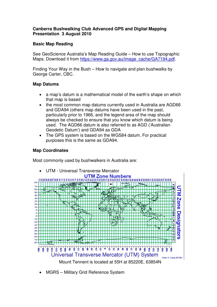
UTM - Universal Transverse Mercator Mount Tennent is located at 55H at 85220E, 63854N • MGRS – Military Grid Reference System

  2. Mount Tennent is located at 55H FA 8522063854, or GR852638 (giving 100m accuracy and with the nearest same GR being 100km away) • Latitude and Longitude Any point on the earth can be uniquely identified by its geographical coordinates, given as latitude and longitude. Latitude is the angular expression of the distance north or south from the equator (0º latitude). The South Pole is at 90ºS and the North Pole at 90ºN. Longitude is the angular expression of the distance east or west from the imaginary line known as the Prime (Greenwich) Meridian - 0º longitude on all maps. Latitude (aka parallels) and longitude (aka meridians) are measured in degrees (º), minutes (') and seconds ("). Each degree is divided into 60 minutes and each minute is divided into 60 seconds. Mount Tennent is at 35º33'5"S,149º2'36"E. Hardware Used • Windows laptop/PC • Garmin Oregon 550T GPS Software Used

  3. • OziExplorer mapping application, Garmin MapSource • GEtrax shareware for KML conversion, GPSBabel for track and waypoint conversion • Google Earth to check going. Data Used • Digital maps 1. Topoview Raster 2006. Current release NSW topographic maps – mainly 2 nd edition 1:25000, some 1:50000 and 1:100000 out west. The product also has a seamless mosaic of all of NSW, and non- current maps (eg. 1 st edition 1:25000 maps around the ACT, handy for checking out old fire trails) 2. ACT Special 1:250000 3. Others eg. 1:50000 maps 4. OZtopo V2.1b topo maps on GPS and PC 5. Scanned maps eg. From Tasmania. Any map can be scanned and calibrated for use with OziExplorer. • Height data – Geoscience Australia 9sec DEM data. Planning a Walk 1. Draw the proposed track and save it 2. Set waypoints with descriptions and save them 3. Create a Route Card by • Summing the proposed track distances between waypoints (if the distance between waypoints was used, this is only a straight line distance) • Record the magnetic bearing between waypoints • Check the track profile for ups and downs • Check the going from map, non-current map, Google Earth 4. Download waypoints to GPS and save them. IMPORTANT – Understand what it all means. Executing the Walk 1. Leave GPS running to record actual track 2. Set waypoints at significant features 3. Navigate using map and compass and route card. Use GPS for confirmation/emergency 4. Sweat or shiver, puff and pant, try not to cuss. After the Walk 1. Upload actual track from GPS and save 2. Compare with planned track 3. Upload waypoints from GPS and save. Tidy them up 4. View actual track profile 5. Relive the joy and pain and navigational embarrassments

  4. 6. Use GEtrax to convert waypoints and track to KML. Use Google Earth to display and save as KMZ file. Blog Blog at http://jevans.pcug.org.au contains trip reports, pictures, video clips, embedded Google Earth, KMZ files, audio podcasts, map fragments, bagging lists, links to other useful sites, things that amuse and interest me. Karen Cody’s Mar-Apr10 AAWT; Mike Bremers’ paddling on the Murray and Murrumbidgee. There is an RSS feed if you wish to be notified whenever a new walk report is available. That’s it, folks. Thanks. John Evans

Download Presentation
Download Policy: The content available on the website is offered to you 'AS IS' for your personal information and use only. It cannot be commercialized, licensed, or distributed on other websites without prior consent from the author. To download a presentation, simply click this link. If you encounter any difficulties during the download process, it's possible that the publisher has removed the file from their server.

Recommend


More recommend