
SLIDE 1
assessment of environmental status (WFD) Baltic Sea types outer - - PowerPoint PPT Presentation
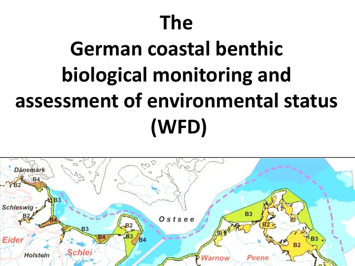
The German coastal benthic biological monitoring and assessment of environmental status (WFD) Baltic Sea types outer shallow water bodies border of river basin border of territorial waters (12 sm) oligohaline inner coastal waters
border of river basin border of territorial waters (12 sm)
mesohaline inner coastal waters mesohaline outer coastal waters meso- polyhaline outer coastal waters, seasonally stratified
border of river basin border of territorial waters (12 sm)
mesohaline inner coastal waters mesohaline outer coastal waters meso- polyhaline outer coastal waters, seasonally stratified
High Status: „All disturbance-sensitive macroalgae and angiosperm taxa associated with undisturbed conditions are present. The levels of macroalgal cover and angiosperm abundance are consistent with undisturbed conditions.“ metrics: perennial species (or ephemeral opportunists as antagonists) diversity aspects (where applicable and feasible) area, cover or depth limits
BALCOSIS assessment system of ecological quality (outer Baltic Sea coast)
[m]
[m]
[% biomass]
[% cover]
[% biomass]
[n of 10]
[% biomass]
border of river basin border of territorial waters (12 sm)
mesohaline inner coastal waters mesohaline outer coastal waters meso- polyhaline outer coastal waters, seasonally stratified
High Status: „All disturbance-sensitive macroalgae and angiosperm taxa associated with undisturbed conditions are present. The levels of macroalgal cover and angiosperm abundance are consistent with undisturbed conditions.“ metrics: perennial species (or ephemeral opportunists as antagonists) diversity aspects (where applicable and feasible) area, cover or depth limits
PHYBIBCO assessment system of ecological quality (inner Baltic Sea coast)
[m]
[m]
[score]
(coastal Baltic Sea und Helgoland:) the MarBIT-Index, 4 modules: species diversity (taxonomic spread) Abundance (lognormal-distribution) proportion of sensitive species proportion of tolerant species
Habitats directive: sandbanks (3) & reefs (3 areas)
sandbanks: BQI & site specific species inventory reefs: site specific species inventory & NN (under development)
No task for monitoring (desk top studies)
MSFD: mud & sand : predominant habitats (EUNIS level 2/3) – monitoring system under development Coarse sand & gravel: special habitats – currently no monitoring planned current draft: 3 basins 2x per period Mecklenburg Bay: mud wih Arctica Arkona basin: mud with Macoma Pomeranian Bight: sand with CMM few HELCOM monitoring stations for interannuell variability planned: spatial distributionb of samples assessment: BQI (Arctica-indicator in MB)