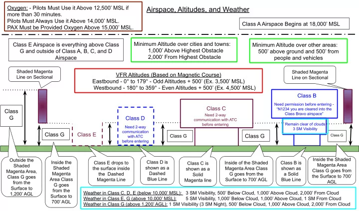

Airspace, Altitudes, and Weather
Class A Airspace Begins at 18,000’ MSL Class B Class C Class D Class G Class G Class G Class E Class E Airspace is everything above Class G and outside of Class A, B, C, and D Airspace
Shaded Magenta Line on Sectional Shaded Magenta Line on Sectional Class G
Class G
VFR Altitudes (Based on Magnetic Course) Eastbound - 0° to 179° - Odd Altitudes + 500’ (Ex. 3,500’ MSL) Westbound - 180° to 359° - Even Altitudes + 500’ (Ex. 4,500’ MSL)
Class D is shown as a Dashed Blue Line Class E drops to the surface inside the Dashed Magenta Line Outside the Shaded Magenta Area, Class G goes from the Surface to 1,200’ AGL Class B is shown as a Solid Blue Line Inside the Shaded Magenta Area Class G goes from the Surface to 700’ AGL Class C is shown as a Solid Magenta line Inside the Shaded Magenta Area Class G goes from the Surface to 700’ AGL Inside of the Shaded Magenta Area Class G goes from the Surface to 700’ AGL
Minimum Altitude over cities and towns: 1,000’ Above Highest Obstacle 2,000’ From Highest Obstacle Minimum Altitude over other areas: 500’ above ground and 500’ from people and vehicles
Need 2-way communication with ATC before entering Need 2-way communication with ATC before entering Need permission before entering - “N1234 you are cleared into the Class Bravo airspace”
Weather in Class C, D, E (below 10,000’ MSL): 3 SM Visibility, 500’ Below Cloud, 1,000’ Above Cloud, 2,000’ From Cloud Weather in Class E, G (above 10,000’ MSL): 5 SM Visibility, 1,000’ Below Cloud, 1,000’ Above Cloud, 1 SM From Cloud Weather in Class G (above 1,200’ AGL): 1 SM Visibility (3 SM Night), 500’ Below Cloud, 1,000’ Above Cloud, 2,000’ From Cloud
Remain clear of clouds 3 SM Visibility
Oxygen: - Pilots Must Use it Above 12,500’ MSL if more than 30 minutes. Pilots Must Always Use it Above 14,000’ MSL. PAX Must be Provided Oxygen Above 15,000’ MSL.