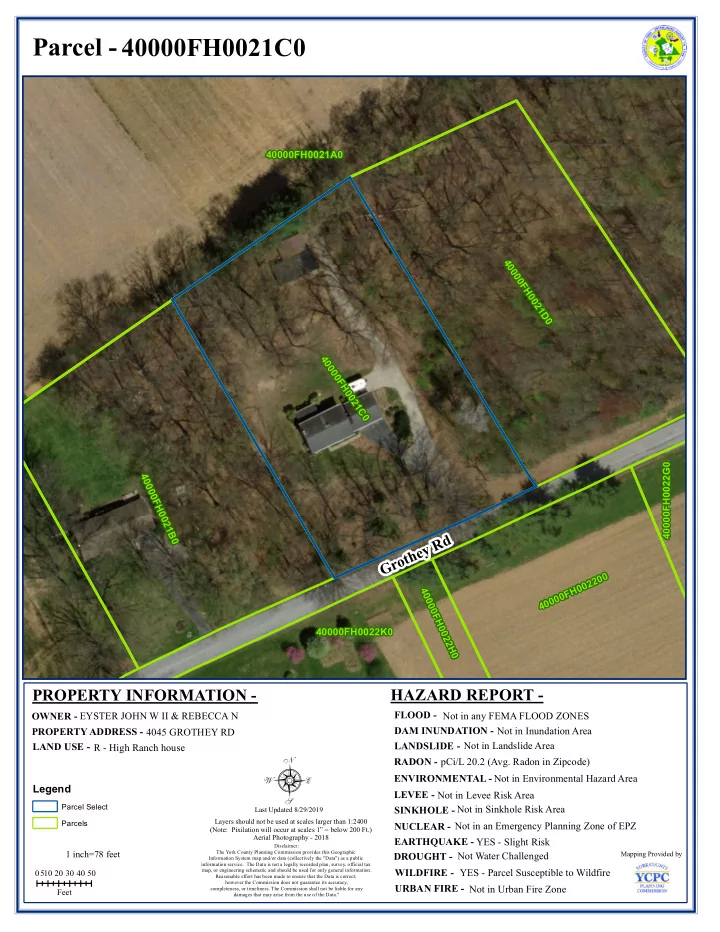
8
play

8 RADON - pC i / L 20. 2 ( A vg. R adon i n Zi pcode) - PDF document

Parcel - 40000FH0021C0 40000FH0021A0 40000FH0021D0 4 0 0 0 0 F H 0 0 2 1 C 0 40000FH0022G0 40000FH0021B0 Grothey Rd 40000FH002200 4 0 0 0 0 F H 0 40000FH0022K0 0 2 2 H 0 HAZARD REPORT - PROPERTY INFORMATION -


  1. Parcel - 40000FH0021C0 40000FH0021A0 40000FH0021D0 4 0 0 0 0 F H 0 0 2 1 C 0 40000FH0022G0 40000FH0021B0 Grothey Rd 40000FH002200 4 0 0 0 0 F H 0 40000FH0022K0 0 2 2 H 0 HAZARD REPORT - PROPERTY INFORMATION - FLOOD - OWNER - EY STER JO H N W I I & R EB EC C A N N ot i n any FEM A FLO O D ZO N ES DAM INUNDATION - N ot i n I nundat i on A r ea PROPERTY ADDRESS - 4 04 5 G R O TH EY R D N ot i n Landsl i de A rea LAND USE - LANDSLIDE - R - H i gh R anch house 8 RADON - pC i / L 20. 2 ( A vg. R adon i n Zi pcode) ENVIRONMENTAL - N ot i n Envi r onm ent al H azar d A r ea Legend LEVEE - N ot i n Levee R i sk A r ea Parcel Select SINKHOLE - N ot i n Si nkhol e R i sk A r ea Last U pdat ed 8/ 29/ 201 9 Layers shoul d not be used at scal es l ar ger t han 1: 24 00 Parcels NUCLEAR - N ot i n an Em er gency Pl anni ng Zone of EPZ ( N ot e: Pi xi l at i on w i l l occur at scal es 1” = bel ow 200 Ft . ) A er i al Phot ogr aphy - 201 8 EARTHQUAKE - Y ES - Sl i ght R i sk D i scl ai m er: 1 i nch= 7 8 f eet The Yor k C ount y Pl anni ng C om m i ssi on provi des t hi s G eogr aphi c N ot W at er C hal l enged M appi ng Pr ovi ded by DROUGHT - I nf or m at i on Syst em m ap and/ or dat a ( col l ect i vel y t he " D at a" ) as a publ i c i nf or m at i on servi ce. The D at a i s not a l egal l y r ecorded pl an, sur vey, of f i ci al t ax Y ES - Par cel Suscept i bl e t o W i l df i r e m ap, or engi neer i ng schem at i c and shoul d be used for onl y gener al i nf orm at i on. WILDFIRE - 0 1 0 20 30 4 0 50 5 R easonabl e ef f ort has been m ade t o ensure t hat t he D at a i s cor rect ; how ever t he C om m i ssi on does not guar ant ee i t s accur acy, URBAN FIRE - N ot i n U r ban Fi r e Zone com pl et eness, or t i m el i ness. T he C om m i ssi on shal l not be l i abl e f or any Feet dam ages t hat m ay ar i se f r om t he use of t he D at a. "

  2. SITE-SPECIFIC HAZARD LIST FOR 40000FH0021C0 1 - Radon Information 2 - Earthquake Information 3 - Wildfire Information Page 1/1

  3. R ADON E XPOSURE D EFINITION – Radon is a cancer-causing natural radioactive gas that you can't see, smell, or taste. It is a large component of the natural radiation that humans are exposed to and can pose a serious threat to public health when it accumulates in poorly ventilated residential and occupation settings. According to the USEPA, radon is estimated to cause about 21,000 lung cancer deaths per year, second only to smoking as the leading cause of lung cancer (EPA 402-R-03-003: EPA Assessment, 2003). An estimated 40% of the homes in Pennsylvania are believed to have elevated radon levels (Pennsylvania Department of Environmental Protection, 2009). M ITIGATION A CTIONS FOR R ESIDENTS ► Testing – Conduct Radon testing to see if levels are above the safe level of 4 pCi/L established by the EPA. ► Remediation – If Radon levels are above 4 pCi/L, hire a certified Radon-Reduction Contractor to fix the problem. M ITIGATION A CTIONS FOR M UNICIPALITIES ► Adopt the York County Hazard Mitigation Plan by resolution or develop and implement a municipal hazard mitigation plan. York County Hazard Mitigation Plan ► Public Education and Outreach – Inform residents of the dangers and possibility of Radon in your municipality through mailings, web page, etc. and encourage testing and abatement. A Supplemental Guide to the 2018 York County Hazard Mitigation Plan 1

  4. E ARTHQUAKE D EFINITION – An earthquake is the motion or trembling of the ground produced by sudden displacement of rock usually within the upper 10-20 miles of the Earth's crust. Earthquakes result from crustal strain, volcanism, landslides, or the collapse of underground caverns. Earthquakes can affect hundreds of thousands of square miles, cause damage to property measured in the tens of billions of dollars, result in loss of life and injury to hundreds of thousands of persons, and disrupt the social and economic functioning of the affected area. Most property damage and earthquake- related deaths are caused by the failure and collapse of structures due to ground shaking which is dependent upon amplitude and duration of the earthquake. (FEMA, 1997). M ITIGATION A CTIONS FOR R ESIDENTS ► Personal Preparedness – It is important to plan for disasters. Families may not be together or at home. Consider completing the following to be prepared. ● Family Emergency Communication Plan (FEMA) serves as a comprehensive checklist for household disaster preparedness. FEMA Family Emergency Communication Plan Checklist ● Family Disaster Plan (American Red Cross) – Communication networks and electricity could be disrupted. Planning in advance will help ensure that all the members of your household know how to reach each other and where to meet up in an emergency. American Red Cross Family Disaster Plan Template ● Emergency Kits – It is always a good idea to have an emergency kit on hand. Consider basic items as well as special needs. Build a Kit (Ready.gov) ready.gov Build-a-Kit Survival Kit Supplies (American Red Cross) American Red Cross Survival Kit Supplies Checklist ► Emergency Alerts and Warnings – To receive emergency alerts and warnings, refer to the following websites, mobile apps, and other resources. ● American Red Cross Mobile Apps (Apple App Store, Google Play, or text to “90999” Mobile Apps - The American Red Cross ● South Central Alert – This service allows residents and businesses in an eight county area to be notified of an emergency situation and important alert messages in a variety of ways, including on their cell phones, home and work phones, by text messaging and e-mail. South Central Alert - Sign Up ● Monitor police news feeds, weather, and news on social media or websites. Receiving periodic updates is vital. ► Retrofitting (Securing Building Components and Contents) – Many injuries in earthquakes are caused by nonstructural hazards, such as attachments to buildings. Activities that can reduce the A Supplemental Guide to the 2018 York County Hazard Mitigation Plan 1

  5. E ARTHQUAKE risk of injury and damage include: anchoring tall bookcases and file cabinets, installing latches on drawers and cabinet doors, restraining desktop computers and appliances, using flexible connections on gas and water lines, mounting framed pictures and mirrors securely, and anchoring and bracing propane tanks and gas cylinders. ► Identify Safe Places – Within each room of home identify safe places under sturdy furniture, against insider walls, and away from glass. Outside of home locate safe places away from buildings, trees, electric lines, and bridges. ► In-Home Safety – Know how to turn off gas, electricity and water within home. M ITIGATION A CTIONS FOR M UNICIPALITIES ► Adopt the York County Hazard Mitigation Plan by resolution or develop and implement a municipal hazard mitigation plan. York County Hazard Mitigation Plan ► Prepare a Continuity of Operations Plan to ensure that essential functions continue to be performed under a broad range of circumstances, protecting residents and minimizing business interruption. Consider what capital improvements are needed to adequately protect business or properties. FEMA Continuity of Operations Brochure ► Prepare an Emergency Operations Plan which describe who will do what, as well as when, with what resources, and by what authority – before, during, and immediately after an emergency. FEMA Guide for All Hazards Emergency Operations Planning Guide ► Coordination – Develop pre-disaster Memorandums of Agreements or Memorandum of Understanding with adjacent jurisdictions. Build partnerships (neighborhoods, emergency management/first responders, businesses, utility service providers, and local government agencies to strengthen response and recovery. ► Public Education and Outreach – Educate residents regarding risk and impact of hazards, how to prepare and protect themselves and their property. Facilitate funding for mitigation measures and technical assistance programs that address measures that citizens can take. ► Seismic Hazard Mapping and Related Hazard Mapping – Information gained from seismic hazard mapping can be used to assess risk. The first step is collection of geologic information on seismic sources, soil conditions, and related potential hazards. The second step is to prepare a map showing the approximate locations of various hazards. Other earthquake-related hazards include liquefaction and landslides. Maps of these related hazards may be used for vulnerability analysis and risk assessment. ► HAZUS – FEMA's HAZUS is a computer-based tool that can be used to quantitatively estimate losses from an earthquake. A Supplemental Guide to the 2018 York County Hazard Mitigation Plan 2

Download Presentation
Download Policy: The content available on the website is offered to you 'AS IS' for your personal information and use only. It cannot be commercialized, licensed, or distributed on other websites without prior consent from the author. To download a presentation, simply click this link. If you encounter any difficulties during the download process, it's possible that the publisher has removed the file from their server.

Recommend


More recommend