75 75
play

75% 75% suggest Cushman Construction cost Trail prioritize a - PDF document

CUSHMAN TRAIL PHASE V PLANNING STUDY Bethel Burley Rd SE Bethel Burley Rd SE Olalla Olalla 16 SE Nelson Road SE Nelson Road SE Pine Road SE Pine Road Burley Burley SE Spruce Rd SE Spruce Rd KITSAP COUNTY KITSAP COUNTY Willow Rd SE


  1. CUSHMAN TRAIL PHASE V PLANNING STUDY Bethel Burley Rd SE Bethel Burley Rd SE Olalla Olalla 16 SE Nelson Road SE Nelson Road SE Pine Road SE Pine Road Burley Burley SE Spruce Rd SE Spruce Rd KITSAP COUNTY KITSAP COUNTY Willow Rd SE Willow Rd SE 66th Ave NW 66th Ave NW 62nd Ave NW 62nd Ave NW SE 160th St SE 160th St PIERCE COUNTY PIERCE COUNTY Maplewood Maplewood 302 1 1 4 4 t t h h 144th St NW 144th St NW A A 302 v v e e Purdy Purdy N N W W 54th Ave NW 54th Ave NW 302 Hallstrom Dr NW Hallstrom Dr NW P P u u Wauna Wauna r r d d y y D D r r N N W W Peacock Hill Ave NW Peacock Hill Ave NW C C r r e e s s c c e e Henderson Bay Henderson Bay n n t t Canterwood Blvd NW Canterwood Blvd NW V V a a l l l l e e y y R R d d G G S S o o E E o o d d n n o o u u g g h h D D r r N N W W Borgen Blvd Borgen Blvd B B H H u u a a r r r r n n b b h h o o a a r r m m Drummond Dr NW Drummond Dr NW H H D D i i Sehmel Dr NW Sehmel Dr NW l l r r l l D D N N r r W W 16 Vernhardson St Vernhardson St Bujacich Rd NW Bujacich Rd NW 
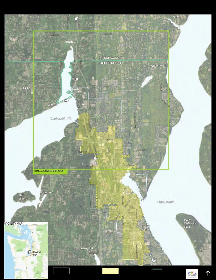
TRAIL ALIGNMENT MAP AREA Gig Gig Rosedale Rosedale Harbor Harbor Raft Raft S S Island Island t t i i n n s s o o Pioneer Way Pioneer Way n n Puget Sound Puget Sound A A v v e e S S o o u u n n Wollochet Dr NW Wollochet Dr NW d d v v i i e e w w 3 3 D D 8 8 t t r r h h Point Point A A v v e e Defi Defi ance ance VICINITY MAP N N W W Shore Shore Park Park Acres Acres W W S S t t N N 5 5 6 6 t t h h P P o o i i n n Artondale Artondale t t F F o o s s d d PROJECT Wollochet Bay Wollochet Bay i i c c k k Estuary Park Estuary Park D D AREA r r N N W W 16 URBAN GROWTH CITY OF GIG HARBOR COUNTY LINE BOUNDARY CITY LIMITS NTS NORTH

  2. CUSHMAN TRAIL PHASE V PLANNING STUDY PUBLIC PROCESS PUBLIC PROCESS Importance of guiding principles Safety and security of trail of survey respondents 75% 75% suggest Cushman Construction cost Trail prioritize a route Create opportunities for for recreational use funding partnerships Accessibility of trail Limits impact to natural environment Ease of maintenance Your vision for this trail extension 0% 10% 20% 30% 40% 50% 60% 70% 80% 90% 100% Transport ation 1 (Not Important) 2 3 4 5 (Very Important) Don’t Know People Community Access Enjoy Safe Experience K Place Nature Connect i Walk d Connection s Bicycle Natural Trail-System E See x Traffic t Bike e n s i o Minimize n Parking Create Family Recreation Recreational Use Roads Great Visibility Current-Trail

  3. CUSHMAN TRAIL PHASE V PLANNING STUDY GUIDING PRINCIPLES GUIDING PRINCIPLES The phase 5 trail extension will building upon the fi rst 4 phases. The trail will maintain a 10’ wide paved surface with gravel shoulders, and serve as a non-motorized multi-purpose trail. Final trail design will comply with local adopted standards for a shared use path. DEFINITIONS Prioritizes a trail corridor with safe crossings of all roadways and intersections, trail separation from vehicle traffi c, open site lines along the trail, numerous Safety and security of trail entrances and exit points, and minimizes hiding spots. Prioritizes universal use by all ages and physical abilities by minimizing steep slopes. Accessibility of trail Ease of maintenance Prioritizes limiting long-term maintenance efforts across entirety of the trail through a reduction in the number of off-grade structures (e.g. bridges, tunnels, boardwalks, etc.) and careful material selection; minimizes disruption to partner agency maintenance (i.e. does not negatively impact access to infrastructure such as power lines, culverts, maintained ditches, etc.), lessens new and out of the way territory for maintenance crews. Prioritizes a route which minimizes tree removals, wetland impacts, and habitat disruption during– and post–construction. Limits impact to natural environment Prioritizes a route with the lowest up-front construction costs by minimizing the number of off–grade structures along the trail, utilizing existing pavement, and Construction Cost minimizing the need to purchase additional right of way. Prioritizes routes with the highest potential to receive outside funding from grants and partnership opportunities with other organizations and agencies, and Create opportunities for tailoring trail/offshoots to better align with funding sources. Many grant opportunities will also require the trail to meet federal standards (in addition to local funding partnerships adopted standards). Prioritizes routes that connect to identifi ed waypoints. Waypoints include Purdy, St. Anthony Hospital, businesses, Peninsula High School, Purdy Elementary Connections to waypoints School, transit stops, other communities, and connections to existing trails and/or routes to the north. and major destinations Prioritizes a route in close proximity to nature where families, walkers, recreational bicyclists, and alternative wheeled transportations can use the trail for Trails proximity to nature exercise, enjoyment of the outdoors, views, and scenic journeys away from loud roads.

  4. CUSHMAN TRAIL PHASE V PLANNING STUDY ALTERNATIVES ALTERNATIVES SE Nelson Rd SE Nelson Rd SE Nelson Rd SE Nelson Rd SE Nelson Rd SE Nelson Rd Burley Burley Burley Burley Burley Burley 16 16 16 SE 160th St SE 160th St Maplewood Maplewood SE 160th St SE 160th St Maplewood Maplewood SE 160th St SE 160th St Maplewood Maplewood Burley Lagoon Burley Lagoon Burley Lagoon Burley Lagoon Burley Lagoon Burley Lagoon 302 302 302 Crescent Lake Crescent Lake Crescent Lake Crescent Lake Crescent Lake Crescent Lake 144th St NW 144th St NW 144th St NW 144th St NW 144th St NW 144th St NW Purdy Purdy Purdy Purdy Purdy Purdy Wauna Wauna Wauna Wauna Wauna Wauna LEGEND Henderson Bay Henderson Bay Crescent Valley Rd SE Crescent Valley Rd SE Henderson Bay Henderson Bay Crescent Valley Rd SE Crescent Valley Rd SE Henderson Bay Henderson Bay Crescent Valley Rd SE Crescent Valley Rd SE EXISTING CUSHMAN TRAIL PROPOSED CUSHMAN TRAIL TRAIL CONNECTION URBAN GROWTH BOUNDARY Borgen Blvd Borgen Blvd Borgen Blvd Borgen Blvd Borgen Blvd Borgen Blvd GIG HARBOR CITY LIMITS COUNTY LINE 1 2 3 TRAIL HEAD 16 16 16 NORTH NTS Gig Harbor Gig Harbor NORTH NTS Gig Harbor Gig Harbor NORTH NTS Gig Harbor Gig Harbor GUIDING PRINCIPLES mostly along roadway corridors but lots of partially separated from roadway corridors, mostly separated from roadway corridors, Safety and security of trail opportunity to get on / o ff some ability to get on/o ff less ability to get on/o ff the trail; safety the trail the trail concerns with roundabout intersections least topography, but further from some topography, but still not very some topography, partially connected to Accessibility of trail residential areas connected to residential areas residential areas close to roadway for access, lots of ‘eyes close to roadway for easy access, some most restrictive access, limited ‘eyes on Ease of maintenance on trail’ to discourage vandalism, etc. ‘eyes on trail’ to discourage vandalism, etc. trail’ to discourage vandalism, etc. limited tree removal with route along some tree removal where trail separated most tree removal with greatest separation Limits impacts to natural roadway corridor from roadway corridor of the trail from roadway corridor environment minimizes structures needed but di ffi needs major structures and improvements needs major structures and improvements cult Construction cost to cross SR16 to cross SR16 slope adjacent to SR16 close to urban center / future development close to urban center / future development connects to St. Anthony’s Hospital and Create opportunities for area but not near residential areas and not area but not near residential areas and not potential for connection to urban center / funding partnerships connected to St. Anthony’s Hospital connected to St. Anthony’s Hospital future development area Connections to waypoints connects to 1 waypoint connects to 2 waypoint connects to 3 waypoint and major destinations potential views to the bay potential views to the bay open space along the power line corridor Trails proximity to nature and potential views to the bay

Download Presentation
Download Policy: The content available on the website is offered to you 'AS IS' for your personal information and use only. It cannot be commercialized, licensed, or distributed on other websites without prior consent from the author. To download a presentation, simply click this link. If you encounter any difficulties during the download process, it's possible that the publisher has removed the file from their server.

Recommend


More recommend