Trekking map Kailash/Gurla Mandhata 1:100,000 Jacob Trltzsch, Jan - - PowerPoint PPT Presentation

trekking map kailash gurla mandhata 1 100 000
SMART_READER_LITE
LIVE PREVIEW

Trekking map Kailash/Gurla Mandhata 1:100,000 Jacob Trltzsch, Jan - - PowerPoint PPT Presentation

Faculty of Environmental Sciences, Institute of Cartography Trekking map Kailash/Gurla Mandhata 1:100,000 Jacob Trltzsch, Jan Kropek, Manfred Buchroithner, Benjamin Schrter Technische Universitt Dresden, Institute of Cartography


slide-1
SLIDE 1

Faculty of Environmental Sciences, Institute of Cartography

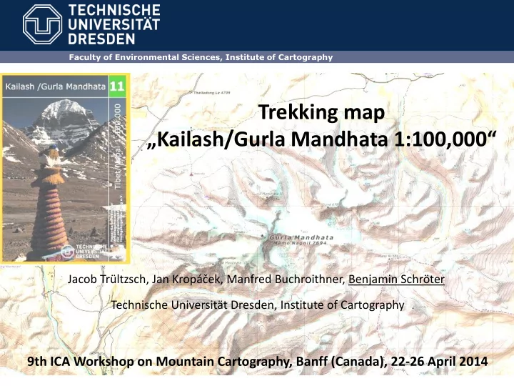
Trekking map „Kailash/Gurla Mandhata 1:100,000“

Jacob Trültzsch, Jan Kropáček, Manfred Buchroithner, Benjamin Schröter Technische Universität Dresden, Institute of Cartography

9th ICA Workshop on Mountain Cartography, Banff (Canada), 22-26 April 2014

slide-2
SLIDE 2

Faculty of Environmental Sciences, Institute of Cartography

Motivation

  • 1. Several trekking maps of high mountain areas worldwide have been published at

Institute of Cartography, TU Dresden

  • 2. Complete Himalaya Map Series
  • 3. Demand for an up-to-date map showing this benchmark area of TiP/WET
  • 4. Product!!!
slide-3
SLIDE 3

Faculty of Environmental Sciences, Institute of Cartography

slide-4
SLIDE 4

Faculty of Environmental Sciences, Institute of Cartography

Framework within research projects: TiP and WET

slide-5
SLIDE 5

Faculty of Environmental Sciences, Institute of Cartography

Some Information

  • 1. Outstanding cultural and religious importance – pilgrimage (Kailash and Lake

Manasarovar circuits)

  • 2. Natural beauty – Climbing/trekking tourism (Gurla Mandhata, Limi Valley)
  • 3. 4 big rivers of SE Asia originate here: N – Indus, E – Brahmaputra, S – Karnali,

W – Sutlaj – religious importance and water sources

slide-6
SLIDE 6

Faculty of Environmental Sciences, Institute of Cartography

Data sources and collection/challenges

  • 1. High resolution satellite imagery: Pleiades, DEM ASTER+SRTM
  • 2. Digitization performed as social cartography project „Coffee Break Mapping“ – 16

quadrants with common mapping guidelines

slide-7
SLIDE 7

Faculty of Environmental Sciences, Institute of Cartography

Kloster K Punkt Durch Panoramio Bilder zu erkennen, Tibetisch Gompa Tschörten T Punkt Stupa; oft weiß gestrichen Gebetsfahnen GF Punkt Kann deutlich kleiner als dieses Beispiel sein Windschutz für Tiere WS Punkt Diese Windschütze die als UFO aussehen kommen ziemlich oft vor. Bestehen von steinernen Mauern und gut gedüngten Boden. Gletscher GL Polygon den Bergschrund muss man einfach abschätzen

slide-8
SLIDE 8

Faculty of Environmental Sciences, Institute of Cartography

Data sources and collection/challenges

  • 1. High resolution satellite imagery: Pleiades, DEM ASTER+SRTM
  • 2. Digitization performed as social cartography project „Coffee Break Mapping“ – 16

quadrants with common mapping guidelines

  • 3. Ground data collected during 3 strenuous field trips
  • 4. Local knowledge on toponymic data (hard to get, especially Tibet/China)
  • 5. Significant differences between western/standard Tibetan language, various kinds
  • f transcriptions
  • 6. Tibetologists checked all names/spelling
slide-9
SLIDE 9

Faculty of Environmental Sciences, Institute of Cartography

slide-10
SLIDE 10

Faculty of Environmental Sciences, Institute of Cartography

slide-11
SLIDE 11

Faculty of Environmental Sciences, Institute of Cartography

slide-12
SLIDE 12

Faculty of Environmental Sciences, Institute of Cartography

slide-13
SLIDE 13

Faculty of Environmental Sciences, Institute of Cartography

slide-14
SLIDE 14

Faculty of Environmental Sciences, Institute of Cartography

Further questions: skal.trylc@gmail.com

Thank you very much for your attention! !And finally the map!