
SLIDE 1
Squamish Oceanfront Peninsula Sub Area Plan Table of Contents 1 - - PDF document
Schedule N to the District of Squamish Official Community Plan 2500, 2017 Squamish Oceanfront Peninsula Sub Area Plan Table of Contents 1 Visio n fo r the Oc e a nfro
3
District of Squamish
1 Visio n fo r the Oc e a nfro nt..................................................................................9
1.1 Oc e a nfro nt T he me s............................................................................................................10 1.2 Oc e a nfro nt Va lue ...............................................................................................................11
2 Ba c kg ro und.......................................................................................................11
2.1 Ove rvie w..............................................................................................................................11 2.2 Co nte xt a nd Histo ry............................................................................................................12 2.3 Site De sc riptio n....................................................................................................................14 2.4 Wha t is a Sub Are a Pla n? ...................................................................................................15 2.5 Pla nning Pro c e ss.................................................................................................................15
3 Pla nning F ra me wo rk.........................................................................................16
3.1 Oc e a nfro nt Guiding Princ iple s.........................................................................................16 3.2 A Susta ina b le Appro a c h to the Oc e a nfro nt..................................................................17
4 E xisting Co nditio ns............................................................................................18
4.1 Site Co nte xt........................................................................................................................18 4.2 Vie ws...................................................................................................................................19 4.3 E xisting Building s ................................................................................................................19 4.4 Wind....................................................................................................................................19 4.5 Ma rine Struc ture s a nd Curre nt Re ta ining Wa lls...............................................................19 4.6 T
4.7 Ge o te c hnic a l......................................................................................................................20 4.8 Hydro lo g y...........................................................................................................................20 4.9 So ils a nd Gro undwa te r Co nta mina tio n ........................................................................20 4.10 E xisting Ha b ita t.................................................................................................................21 4.11 F ish a nd Wildlife ................................................................................................................22 4.12 Arc ha e o lo g ic a l Asse ssme nt............................................................................................23 4.13 Site Ac c e ss.........................................................................................................................23
5 Po lic y F ra me wo rk..............................................................................................23
5.1 Ove rvie w a nd L a nd Use Distrib utio n................................................................................23 5.2 T he Visio n..............................................................................................................................26 5.2.1 De sc riptio n........................................................................................................................26 5.3 L a nd Use Pla n......................................................................................................................30 5.3.1 Ge ne ra l Ob je c tive s.........................................................................................................31 5.3.2 Villa g e Ce ntre ..................................................................................................................32
4
Squamish Oceanfront Peninsula Sub Area Plan
5.3.3 Wa te rfro nt E mplo yme nt..............................................................................................34 5.3.4 Prima ry E mplo yme nt...................................................................................................35 5.3.5 Ma in Stre e t F le x Use ....................................................................................................36 5.3.6 E duc a tio n a nd I nstitutio n............................................................................................37 5.3.7 Ca tte rmo le Slo ug h F le x Use .......................................................................................38 5.3.8 Ca tte rmo le Wa te rfro nt Re side ntia l...........................................................................39 5.3.9 Ma mq ua m Wa te rfro nt Re side ntia l...........................................................................40 5.3.10 I nte rio r Re side ntia l......................................................................................................41 5.3.11 Ne ig hb o urho o d Co mme rc ia l..................................................................................42 5.3.12 Ma rina s a nd Wa te rfro nt Struc ture s.........................................................................43 5.4 Pa rks, Pub lic Spa c e s a nd Co mmunity F a c ilitie s.........................................................46 5.4.1 Ove ra ll Ob je c tive s.......................................................................................................46 5.4.2 Po lic ie s...........................................................................................................................46 5.4.3 Oc e a nfro nt Be a c h a nd Pa rk.....................................................................................48 5.4.4 Villa g e Co mmo ns........................................................................................................49 5.4.5 Ga lb ra ith Pa rk..............................................................................................................50 5.4.6 Ca tte rmo le We tla nd...................................................................................................50 5.4.7 Oc e a nfro nt Wa lkwa y a nd T ra ils.................................................................................51 5.4.8 Oc e a nfro nt Pie r...........................................................................................................52 5.4.9 Wa te r............................................................................................................................52 5.4.10 Civic Use .....................................................................................................................53 5.5 Building s a nd Built F
5.5.1 Ge ne ra l Ob je c tive s.....................................................................................................55 5.5.2 He ig ht, De nsity a nd Ma ssing .....................................................................................56 5.5.3 Cha ra c te r a nd I de ntity...............................................................................................57 5.5.4 Building a nd Pub lic Re a lm..........................................................................................59 5.5.5 Site L a ndsc a ping .........................................................................................................59 5.6 Ac c e ss a nd Circ ula tio n..................................................................................................60 5.6.1 Ob je c tive s.....................................................................................................................60 5.6.2 Wa lking a nd Cyc ling Po lic ie s.....................................................................................61 5.6.3 Pub lic T ra nsit Po lic ie s...................................................................................................62 5.6.4 Ro a d Ac c e ss a nd Circ ula tio n Po lic ie s......................................................................62 5.6.5 Ma rine T ra nspo rta tio n Po lic ie s...................................................................................64 5.6.6 Pa rking Po lic ie s.............................................................................................................65 5.7 Susta ina b ility.....................................................................................................................66 5.7.1 Ge ne ra l Ob je c tive s....................................................................................................66 5.7.2 E nviro nme nta l Susta ina b ility a nd Ha b ita t E nha nc e me nt......................................67 5.7.3 E c o no mic Susta ina b ility..............................................................................................70 5.7.4 So c ia l Susta ina b ility.......................................................................................................72
5
District of Squamish
5.7.5 Built fo rm Susta ina b ility.................................................................................................73 5.8 I nfra struc ture .....................................................................................................................75 5.8.1 Ge ne ra l Ob je c tive s.......................................................................................................76 5.8.2 Ge o te c hnic a l a nd F lo o d Pro te c tio n...........................................................................77 5.8.3 Wa te r...............................................................................................................................78 5.8.4 Sa nita ry a nd Se we r........................................................................................................80 5.8.5 Off-Site Se we r a nd Wa te r I nfra struc ture ......................................................................81 5.8.6 Sto rm Wa te r....................................................................................................................82 5.8.7 Wa ste ...............................................................................................................................83 5.8.8 Dry Utilitie s........................................................................................................................83 5.8.9 Gro undwa te r a nd So il Re me dia tio n............................................................................84 5.8.10 I nfra struc ture Pha sing Re q uire me nts..........................................................................84
6 De ve lo pme nt Pe rmit Are a No . 12 Guide line s.............................................85
6.1 Applic a tio n a nd I nte nt....................................................................................................85 6.2 De sig na tio n.......................................................................................................................85 6.3 ustication.......................................................................................................................85 6.4 E xe mptio ns........................................................................................................................86 6.5 Use o f the Guide line s.......................................................................................................86 6.6 De ve lo pme nt Pe rmit Guide line s F ra me wo rk................................................................87 6.7 De ve lo pme nt Pe rmit Guide line s F ra me wo rk.................................................................88 6.7.1 Ob je c tive ........................................................................................................................88 6.7.2 Guide line s.......................................................................................................................88 6.8 Ge ne ra l Co mme rc ia l & Mixe d Use De ve lo pme nt Pe rmit Guide line s.......................101 6.8.1 Ob je c tive ......................................................................................................................101 6.8.2 Guide line s.....................................................................................................................101 6.9 Ge ne ra l Re side ntia l De sig n Pe rmit Guide line s (GR)..................................................104 6.9.1 Ob je c tive ......................................................................................................................104 6.9.2 Guide line s.....................................................................................................................104 6.10 Ga te wa y De ve lo pme nt Pe rmit Guide line s (GW)....................................................107 6.10.1 Ob je c tive ....................................................................................................................107 6.10.2 Guide line s...................................................................................................................108 6.11 I nte rio r Re side ntia l De ve lo pme nt Pe rmit Guide line s (I R).........................................108 6.11.1 Ob je c tive ....................................................................................................................108 6.11.2 Guide line s...................................................................................................................109 6.12 Ma mq ua m Wa te rfro nt De ve lo pme nt Pe rmit Guide line s (MW).............................110 6.12.1 Ob je c tive ....................................................................................................................110 6.12.2 Guide line s...................................................................................................................110 6.13 E duc a tio n a nd I nstitutio n De ve lo pme nt Pe rmit Guide line s (I C).............................113
6
Squamish Oceanfront Peninsula Sub Area Plan
6.13.1 Ob je c tive ...................................................................................................................113 6.13.2 Guide line s..................................................................................................................113 6.14 Villa g e Ce ntre De ve lo pme nt Pe rmit Guide line s (VC)............................................116 6.14.1 Ob je c tive ...................................................................................................................116 6.14.2 Guide line s.................................................................................................................116 6.15 Ma ritime De ve lo pme nt Pe rmit Guide line s (M)........................................................118 6.15.1 Ob je c tive ...................................................................................................................118 6.15.2 Guide line s..................................................................................................................118 6.16 Prima ry E mplo yme nt De ve lo pme nt Pe rmit Guide line s (PE )...................................120 6.16.1 Ob je c tive ...................................................................................................................120 6.16.2 Guide line s..................................................................................................................120 6.17 Ca tte rmo le Wa te rfro nt De ve lo pme nt Pe rmit Guide line s (CW)............................122 6.17.1 Ob je c tive ...................................................................................................................122 6.17.2 Guide line s..................................................................................................................122
7 Pla n I mple me nta tio n...................................................................................123
7.1 Pha sing ...........................................................................................................................123 7.2 E mplo yme nt a nd E c o no mic De ve lo pme nt...............................................................123 7.2.1 Po lic ie s..........................................................................................................................123 7.3 Pa rks, Ope n Spa c e , a nd Co mmunity Ame nitie s.......................................................124 7.3.1 Ob je c tive s....................................................................................................................124 7.3.2 Po lic ie s..........................................................................................................................124 7.4 Ac c e ss a nd Circ ula tio n................................................................................................125 7.4.1 Ob je c tive s....................................................................................................................125 7.4.2 Po lic ie s..........................................................................................................................125 7.5 I nfra struc ture a nd E nviro nme nt...................................................................................125 7.5.1 Po lic ie s..........................................................................................................................125
8.1 Sub Are a Pla n Sc he dule s.............................................................................................125
7
District of Squamish Figure 1 - Final Phase 6 Portrayal........................................................................................................................................................................12 Figure 2 - Site Context............................................................................................................................................................................................15 Figure 3 - Howe Sound...........................................................................................................................................................................................16 Figure 4 - Context Plan............................................................................................................................................................................................18 Figure 5 - Local Starfjshes......................................................................................................................................................................................20 Figure 6 - Site Context Identifjers........................................................................................................................................................................21 Figure 7 - Local Kiteboarder..................................................................................................................................................................................22 Figure 8 - Local Kayakers........................................................................................................................................................................................23 Figure 9 - Master Plan Rendering........................................................................................................................................................................25 Figure 10 - Squamish Village Green....................................................................................................................................................................26 Figure 11 - Rendering of Oceanfront Community Theatre.........................................................................................................................27 Figure 12 - Howe Sound.........................................................................................................................................................................................33 Figure 13 - Local Scenery.......................................................................................................................................................................................33 Figure 14 - Restaurants...........................................................................................................................................................................................34 Figure 15 - Village Centre.......................................................................................................................................................................................35 Figure 16 - Waterfront Employment..................................................................................................................................................................37 Figure 17 - Primary Employment........................................................................................................................................................................38 Figure 18 - Main Street Flex Use...........................................................................................................................................................................39 Figure 19 - Education & Institutions...................................................................................................................................................................40 Figure 20 - Cattermole Slough Flex Use............................................................................................................................................................41 Figure 21 - Cattermole Waterfront Residential...............................................................................................................................................42 Figure 22 - Mamquam Waterfront Residential...............................................................................................................................................43 Figure 23 - Interior Residential.............................................................................................................................................................................44 Figure 24 - Neighbourhood Commercial.........................................................................................................................................................45 Figure 25 - Marinas and Waterfront Structures..............................................................................................................................................46 Figure 26 - Mamquam Blind Channel Marina Area......................................................................................................................................47 Figure 27 - Local Wildlife........................................................................................................................................................................................48 Figure 28 - Howe Sound.........................................................................................................................................................................................53 Figure 29 - Representation Waterfront Illustration.......................................................................................................................................54 Figure 30 - Representation Waterfront Illustration.......................................................................................................................................55 Figure 31 - Howe Sound.........................................................................................................................................................................................56 Figure 32 - Building Massing Rendering...........................................................................................................................................................59 Figure 33 - Oceanfront Village Rendering........................................................................................................................................................60 Figure 34 - Representative Waterfront Illustration.......................................................................................................................................61 Figure 35 - Representative Pedestrian Walkway............................................................................................................................................62 Figure 36 - Sailing on Howe Sound....................................................................................................................................................................69 Figure 37 - Representative Waterfront Illustration.......................................................................................................................................70
8
Squamish Oceanfront Peninsula Sub Area Plan Figure 38 - Representative Bike Board Walk Illustration.................................................................................................................................72 Figure 39 - Squamish Oceanfront...........................................................................................................................................................................73 Figure 40 - Representative Pier Illustration..........................................................................................................................................................73 Figure 41 - Representative Slough Panorama....................................................................................................................................................74 Figure 42 - Sunset over Howe Sound.....................................................................................................................................................................77 Figure 43 - Howe Sound.............................................................................................................................................................................................78 Figure 44 - Representative Stormwater Illustration..........................................................................................................................................82 Figure 45 - Oceanview from the Water..................................................................................................................................................................88 Figure 46 - View Analysis............................................................................................................................................................................................91 Figure 47 - Sun/Shading Lines..................................................................................................................................................................................92 Figure 48 - Desired Building Frontage...................................................................................................................................................................92 Figure 49 - Desired Building Setbacks...................................................................................................................................................................93 Figure 50 - Height Ratio’s............................................................................................................................................................................................93 Figure 51 - Example of Preferred Entrance Types............................................................................................................................................94 Figure 52 - Illustrative Parking Treatment............................................................................................................................................................96 Figure 53 - Illustrative Servicing Treatment.........................................................................................................................................................97 Figure 54 - Illustrative Massing Grades..................................................................................................................................................................97 Figure 55 - Illustrative Facade Treatment.............................................................................................................................................................98 Figure 56 - Illustrative Tall Building Treatment...................................................................................................................................................98 Figure 57 - Wind Consideration...............................................................................................................................................................................99 Figure 58 - Facade Treatment.................................................................................................................................................................................100 Figure 59 - Illustrative Landscaping.....................................................................................................................................................................100 Figure 60 - Entry Protection....................................................................................................................................................................................101 Figure 61 - Example Building Character.............................................................................................................................................................101 Figure 62 - Illustrative Sun Penetration..............................................................................................................................................................102 Figure 63 - Example Building Type to Increase Energy Conservation......................................................................................................103 Figure 64 - Illustrative Ventilation and Solar Access........................................................................................................................................103 Figure 65 - Canopy Preferences.............................................................................................................................................................................106 Figure 66 - Patios........................................................................................................................................................................................................107 Figure 67 - Eyes on the Street.................................................................................................................................................................................109 Figure 68 - Sample Building Types.......................................................................................................................................................................110 Figure 69 - Illustrative Squamish Market............................................................................................................................................................114 Figure 70 - Pedestrian Friendly Wider Public Walkways.................................................................................................................................115 Figure 71 - Sample Architectural Drawings.......................................................................................................................................................116 Figure 72 - Squamish Waterfront Final................................................................................................................................................................119 Figure 73 - Winterfest................................................................................................................................................................................................120 Figure 74 - Sailing in the Sound............................................................................................................................................................................122 Figure 75 - Marina......................................................................................................................................................................................................122 Figure 76 - Knowledge Based Industries............................................................................................................................................................124
9
District of Squamish
The Squamish Oceanfront peninsula is a unique oceanfront development opportunity in the Pacifjc Northwest. Located between the world-class destinations of Whistler and Vancouver, the site is surrounded on three sides by water and all sides by dramatic West Coast vistas, including Howe Sound, the Garibaldi Range, Shannon Falls and the Stawamus Chief. These lands hold the key to the next generation of economic and community growth for the District of Squamish. Though the property presents a rare blank-slate
as Squamish possesses a power of place that was evident to the earliest First Nations and is still palpable today. First Nations values connect people to this land, and play an ever-growing role in Squamish’s future. In addition, the families who built Squamish and its logging industry hold invaluable wisdom about how Squamish has evolved and the opportunities ahead. Finally, in recent years, a community of creative class and outdoor enthusiasts has come to make Squamish home. Along with all those who have come before, these community members have sparked a renewed sense of place and energy - shining new light on what is needed for people to come, stay and thrive, and they have come together to enrich Squamish through their community spirit. But community spirit is no longer enough. What Squamish needs is a vision for a new economic foundation and a mechanism for unlocking the full potential of its assets. As the entire region entered the world stage in 2010 with newly enhanced access throughout the sea-to-sky corridor, an unprecedented opportunity has been created for Squamish to take a confjdent step forward. The time is now. A bold and strategic solution can lead Squamish into a new period of growth and possibility. The Oceanfront peninsula lands are the pivotal assets for bringing a vision for Squamish to life. Residents have already claimed these lands as their own, exposing the potential through their use. When fully developed, these lands will showcase the best of Squamish, capitalizing on the oceanfront to create a work-live-learn-play lifestyle that is authentically Squamish. This new Oceanfront community will revitalize the downtown core, letting its energy radiate throughout all of Squamish. Some of the world’s’ most iconic and admired communities—the most raw, innovative and real—are industry towns
self-suffjcient local culture that only as a consequence has generated strong tourist appeal. Squamish presents a fresh
Figure 1 - Final Phase 6 Portrayal
10
Squamish Oceanfront Peninsula Sub Area Plan The breathtaking natural attributes and indisputable potential of the Oceanfront lands leave everyone wanting and waiting to see what the community will aspire to be. There are some key themes and values that will defjne and shape the experience envisioned for the Oceanfront peninsula. These provide the guiding philosophy for continuing to shape that vision, the planning process and the key steps that will take this community from ideas and blueprints to reality.
1.1 Oc e a nfro nt T he me s
This is an oceanfront community that belongs to the people of Squamish—from a visible respect for First Nations heritage to community-led growth year over year. The community succeeds by enabling local life to thrive. It is rich with opportunities for locals to work, live, play and learn, including a spectrum of amenities that enhance those
staying true to itself. A shared awe of nature—at its most rugged and powerful—draws people in and together. These are people driven by back-to-community values, happy to linger in the moment and build relationships with one another.
Co mmunity F irst Oc e a nfro nt Alive
All paths lead to the water’s edge, realizing the “sea” in sea-to-sky. Sport, art, living, learning—they all meet at the
you from everywhere within the community. The ocean and community feel like one, with the water becoming a constant and powerful presence, magical and grounding.
I nspire d L iving
The grandeur of nature begs you to go further and think bigger. Businesses in the commercial district are fjlled with entrepreneurs, innovators and imagineers. The education complex kindles a culture of experimentation and new
wind or shine the community thrives, defying the powerful weather that plays out over Howe Sound. Visitors feed ofg this all-encompassing ethos of possibility, leaving emboldened, inspired and eager to return.
Susta ina b ility
The Oceanfront will be a model community for sustainable design and living that meets the needs of the present without compromising the ability of future generations to meet their own needs. Implementing this vision of sustainability means that we consider the impact of current development in environmental, social and economic terms; over the long term; and, as part of a system in which buildings, neighbourhoods, and towns are all related to each other and the ecosystem. It is a comprehensive approach to development, where neither the needs of the present are balanced with the needs of the future.
11
District of Squamish
1.2 Oc e a nfro nt Va lue s Authe ntic ity
The Oceanfront community feels genuine and real. There is an honesty in each moment that allows you to relax, lets you trust that all you see is what it seems. No facades. No contrived ambiance. Everything appears to have grown up naturally creating a perfect feeling of fjt.
Ac c e ss
From the Oceanfront community, Squamish explodes around you, ofgering unprecedented and enhanced access to water, mountains and more, sparking fresh exploration of Howe Sound, the Squamish River estuary, the Tantalus Mountains and the Chief. The community feels like a launch pad for opportunity, having eliminated the obstacles to enjoying an ideal Squamish experience. Access also means the Oceanfront is accessible to all users. It is a place without division.
Cre a tivity
The Oceanfront community is fjlled with a sense of freedom and playfulness. The diverse architecture, the eclectic entrepreneurs, the spirited students, the adventuresome sport enthusiasts—they all challenge you to put your own spin on the moment, to consider trying something a little difgerent, to fjnd courage in the daring of others.
Co nne c tio n
The Oceanfront plan creates internal synergistic connections—allowing Squamish to become greater than the sum
the downtown core, and with time they vitalize one another. Furthermore, by combining residential, education, entertainment and commercial uses, the Oceanfront fosters social diversity, community collaborations and endless
2.1 Ove rvie w
The 32 hectare piece of land known as the Squamish Oceanfront peninsula represents a huge opportunity for the District of Squamish and the Region to build a new, authentic waterfront that is a model of smart growth and sustainability. The purpose of this document is to create an Offjcial Community Plan level planning framework to guide the future development of the site. It will outline the policies, guidelines and land-uses anticipated on the Oceanfront Peninsula and, when adopted, will become part of the District of Squamish Offjcial Community Plan.
12
Squamish Oceanfront Peninsula Sub Area Plan
2.2 Co nte xt a nd Histo ry
Looking at this nearly vacant, wind- swept land today, it is sometimes hard to imagine the history and past use
near the waterfront have been used extensively since the turn of the 20th
railway and Highway 99 to Vancouver, the Oceanfront peninsula was efgectively the “gateway” to Squamish, providing deep water access for boats from Vancouver and other ports to ofg-load people and
travelers. With the construction of the railway to the Cariboo in 1915, rail lines traversed the site to allow the shipment of commodities out of the community. Highway 99 to Vancouver opened in 1959, reducing the importance of rail
forest and paper products, minerals, chemicals and mechanical equipment. Industrial uses continued on the Oceanfront from the 1950’s to the 1990’s. During that period, much of this land was owned by British Columbia Rail Company and leased to the Nexen Corporation and other manufacturers of chemicals used in the pulp-and-paper
jobs were associated with the forest sector, from Woodfjbre across the water to the Interfor sawmill. In 1991 however, the strength of the local resource sector began to wane. Over the next 15 years, the Woodfjbre and Interfor mills closed, as did Nexen’s Oceanfront operations, and the rail maintenance yard was downsized when BC Rail was leased to CN Rail. Between 2003 and 2006, Squamish lost around 600 resource sector jobs and $3 million in annual tax revenue. Demonstrating its resilience, Squamish has been working hard to transition to a more diversifjed economy. The District successfully negotiated the transfer of about two thirds of the Oceanfront lands from the Province as a means to create new economic opportunities. In the process, it was ensured that the responsible parties cleaned up soil and groundwater contamination. Figure 2 - Site Context
13
District of Squamish While a few areas require remediation before the Ministry approves development there, and clean-up
groundwater is on-going near the southern end of the peninsula, much of the peninsula has received Certifjcates
Environment, and the mercury does not pose a risk to human or environmental
heavily in economic development, with a strong strategy built around Squamish’s reputation as Outdoor Recreation Capital of Canada. It built the iconic Adventure Centre, which now marks the entry to downtown and speaks to visitors of the community’s potential for the future. At the same time, the Highway 99 expansion has made Squamish even more a part of the larger region, from Whistler to Greater Vancouver. A quickly expanding population – expected to double by 2030 – is one result of this change – bringing both challenges and opportunities, while another is that more residents now commute to Whistler and Vancouver for work. In response to growth pressures, the community embraced the concept of smart growth early, and was the second of fjve BC communities to have participated in the Smart Growth on the Ground planning process. The community has built on that efgort, using smart growth and sustainability as the basis for the new Offjcial Community Plan (OCP), and leading with initiatives such as the Community Energy Action Plan, Climate Action Charter commitment, a sustainability checklist, and the 12-Step Climate Change Pledge. Similarly, to address commuting and strengthen the local economy, the District has led economic development strategies to identify and then draw businesses to town. Through these efgorts, Squamish is evolving into a leading sustainable community in BC, and has set the stage for a vision of sustainability and smart growth. Since 2004, the Oceanfront peninsula has been seen as playing a key role in the evolution of Squamish. The Downtown Waterfront Concept Plan charette created an initial vision for the Oceanfront based on community goals and objectives with a signifjcant emphasis on sustainability. In discussions since then, the community has consistently supported the Figure 3 - Howe Sound
14
Squamish Oceanfront Peninsula Sub Area Plan
2.3 Site De sc riptio n
The Oceanfront Peninsula is located immediately south of downtown Squamish. It is bordered by the Mamquam Blind Channel, Howe Sound, and Cattermole Slough. The natural setting is spectacular: it is surrounded by the Squamish Chief and Shannon Falls to the east, the Coastal Mountains to the north, the Squamish River Estuary to the west, and Howe Sound to the south. Squamish Terminals sits next to the peninsula at the edge of the estuary, while the Squamish Nation’s reserve and the industrial Site B face it from across the Mamquam Blind Channel. The planning area includes the whole peninsula, as far north as Westminster Street, and includes the water lots around it. The land area is 32.6 ha (80.5 acres), and the water lots cover another 32.0 ha (79 acres). Land and water ownership is complex, with many rail and road rights-of-way, fee simple and leased water lots, as well as simple land parcels
Squamish Equinox Rocks Festival use the southern end of the peninsula. One of the most used features of the peninsula is the Squamish Oceanfront Interpretive Trail, mile zero of the Sea to Sky Trail, which follows the waterfront. The peninsula is comprised of imported fjll deposited over underlying estuarine sand and silt. It is close to sea level, has a high water table, and is vulnerable to fmooding in storm events at high tide, and from sea level rise from climate
idea of redeveloping these lands as a sustainable development. They have also been very clear that the community must realize a range of benefjts as a result of the development. The Oceanfront is recognized as a unique asset for Squamish and the region, for a number of reasons. It provides access to the ocean for all Squamish residents, for residents of Whistler, and visitors to Sea-to-Sky country. For business, deep- water access is an essential and unusual asset. It is right next to downtown, so its development can support downtown
Finally, much of it is community-owned, so its redevelopment can do much to support Squamish goals.
15
District of Squamish
The Oceanfront Peninsula Sub Area Plan is a schedule to Squamish’s Offjcial Community Plan (OCP), a bylaw adopted by Council to guide development
land use, building form and character, transportation and circulation, environmental performance, and infrastructure servicing on the Oceanfront peninsula immediately south
The purpose of the Oceanfront Peninsula Sub Area Plan is to guide the actions and decisions of the District as they relate to development approvals for private lands and development of roads, parks, public open spaces, and community facilities. It is intended to ensure that the development of the Oceanfront is coherent and coordinated, and that it achieves the community’s vision of sustainable development that links Squamish to the ocean, as expressed in the Vision and Oceanfront Guiding Principles.
2.5 Pla nning Pro c e ss
Planning for the Oceanfront started with a strong foundation of previous community engagement, planning, and policy work, both focused on the Oceanfront and for Squamish as a whole, including:
informed by this process. The “Create the Oceanfront” planning process started in 2007 engaged extensively with the community to ensure it would refmect community goals and aspirations. Peninsula landowners funded the process and provided expertise and resources to further support it. In Phase 1, technical studies and previous planning work were presented to the public to confjrm starting points for the Oceanfront and Oceanfront Guiding Principles for planning and goals for a sustainable future. Figure 4 - Context Plan
16
Squamish Oceanfront Peninsula Sub Area Plan Phase 2 took place in the fall of 2008, and focused on the issues that remained. A series of four workshops were held with community stakeholders and experts to discuss key issues, including employment, parks and facilities, water’s edge treatment, and land use mix. The priorities and preferences they expressed were then presented to the general public to get a reaction from a wider range of people, through an Open House and “Kitchen Table Discussions.” Throughout, community members discussed the options in light of trade-ofgs and implications, resulting in a well- informed set of priorities and preferences for the Oceanfront. A Policy Statement was produced, and used to guide development of two plan options. These were presented together to the community at an Open House and via the project website in March 2009. Participants rated the two plans, providing direction for revisions and refjnements. Finally, this Oceanfront Peninsula Sub Area Plan was produced, refmecting all of the community input to date, as well as technical and fjnancial considerations.
3.1 Oc e a nfro nt Guiding Princ iple s
In setting the stage for planning the Oceanfront, the community recognized the importance of planning for a sustainable future and developed a set of qualitative principles to guide planning and development of the area. The principles were created through signifjcant community efgort during the past several years during the OCP, Downtown Waterfront Concept Plan, Smart Growth on the Ground Plan, and other major planning processes. They remain the foundation for the vision, and link it to the policies in this plan. Contributes to Squamish: Enhances the vitality of downtown, Squamish as a whole, and the Sea-to-Sky corridor. Strong Identity: Enhances the sense of community, history and connection with the natural world, celebrating the uniqueness of Squamish and the Oceanfront itself. Complete Community: Encourages a healthy, diverse and vital mix of uses. Economic Viability and Business Vitality: Ensures the plan is viable, and supports long-term economic prosperity and resilience through diverse business and employment opportunities. Housing for the Whole Community: Addresses a diversity of housing to match community needs. Access for All: Ensures public access to the waterfront, and emphasizes alternatives to the car. A Model of Green Development: Buildings and infrastructure that are greener, smarter and cheaper; support for a secure and resilient local food system. Environmentally Restorative: In harmony with natural systems, protects and enhances the environment. Enhanced Livability: Designed for safe, healthy experiences, and facilitates social interaction. Everyone Has a Voice: Base planning decisions on an efgective, transparent and inclusive public process.
17
District of Squamish
3.2 A Susta ina b le Appro a c h to the Oc e a nfro nt
Previous planning exercises and community input have consistently stressed that development of the Oceanfront must be a model of sustainability, addressing economic, social and environmental dimensions in a genuine and meaningful way. If it is to make a genuine contribution towards sustainability, the Oceanfront plan and project must make progress in addressing key global and local challenges, including: Protect, Enhance and Rehabilitate Natural Ecosystems – The Oceanfront development will focus on protecting, enhancing and rehabilitating ecological features for people, animals and marine life, and plants. Foster Economic Development – The Oceanfront development will work to achieve the community driven goal of job creation at the Oceanfront important for community sustainability. Aim for reduced Energy use and reduced GHG– The Oceanfront will endorse and support development plans for the District of Squamish Community Energy Action Plan. Support the District’s OCP and Downtown Transportation Plan by designing a community that prioritizes walking, cycling, transit and water-based transportation options over private single occupant vehicles. Build Green Infrastructure and Green Development – The Oceanfront will adopt responsible development principles for building and neighborhood development. The Oceanfront will support “naturalized” storm water management and reduce potable water consumption through the use of low-fmow technologies. The Oceanfront will target “zero waste” and ensure SODC’s waste management strategies are aligned with the policy recommendations
Focus on public open spaces and parks for community cohesion – Support a network of new and existing green spaces that are linked together through the Oceanfront and support ecological and diverse social functions. Honour the culture and heritage of Squamish through vistas, public art, recreational opportunities and park infrastructure Be sustainably focused on Land Use, Density & Site Layout – The Oceanfront will adhere to Smart Growth on the Ground Principles for mixed-use community design including criteria for neighborhood pattern and design. Be accountable to the Community – The Oceanfront will create a dashboard of measurable indicators that allow the community to understand how the Oceanfront is doing against its sustainability targets Figure 5 - Local Sea Life
18
Squamish Oceanfront Peninsula Sub Area Plan
4.1 Site Co nte xt
The Oceanfront is located on the Squamish River delta, where the Squamish River, the Stawamus River and Mamquam Blind Channel meet the sea. Historically, these rivers have changed their locations during fmood events, leading to varying fmuvial deposits of silt sand and gravel across the delta. The Oceanfront site was originally intertidal mud fmats with ground surface at about mean sea level. (El. 0.0m to
had been constructed into Howe Sound by the Pacifjc Great Eastern Railway. By 1957, the “salt loading dock” area
with dredged sand, including a dyked settling pond at the southwest corner of the site. During subsequent plan expansions and development, the site was extended west through the construction of more settling points and fjll
the north end of Howe Sound. Now the land area is 32.6 ha (80.5 acres), and the water lots cover another 32.0 ha (79 acres). Figure 6 - Site Context Identifjers
19
District of Squamish
4.2 Vie ws
The natural features included in the view are the Mamquam Blind Channel, the Chief and Shannon Falls to the East, Views of Howe Sound to the South, views of the Tantalus Range and the Squamish River Estuary to the West, and long views of Garibaldi and Atwell Peaks to the North. There is a view to the Squamish Terminals at the south end of the peninsula facing South West
4.3 E xisting Building s
The buildings that currently reside in the Oceanfront consist of a blue warehouse, a single storey offjce building (which houses the SODC offjces), a warehouse/storage building, an industrial offjce building and another large warehouse at the north end of the site ofg of Galbraith Avenue.
4.4 Wind
The wind is a unique feature of the site. The predominate wind blows from the south-southwest in the summers and reverses for the
0-5 m/s primarily and can gust up to 18 m/s in the winter. Wind speed in the summer is primarily in the 0-5m/s range but is above this for only 30% of the time up to a maximum of 12-15m/s in the
wind speeds have been clocked above 18m/s. The summer winds are thermal in nature and rise and fall over the course of the day, starting between 10:00 and 11:00 am and falling between 7:00 and 8:00 pm.
4.5 Ma rine Struc ture s a nd Curre nt Re ta ining Wa lls
The primary marine structures on the site are the following:
Figure 7 - Local Kiteboarder
20
Squamish Oceanfront Peninsula Sub Area Plan
4.6 T
The Oceanfront has an average elevation, El. 3.0m geodetic datum (El. 6.1m chart datum). Geodetic Datum is an international fjxed elevation reference. Elevations range from El. 4.5m geodetic on the Cattermole side to El. 2.5m geodetic on the Mamquam Blind Channel side of the property. Slope angles on the foreshore vary from 3H:1V along the south side, 2.5H:1V on the east side, to some steeper 1.75V:1V sections on the southeastern side.
4.7 Ge o te c hnic a l
A geotechnical site evaluation was conducted by Klohn Crippen in July 2005 that consisted of 8 cone penetration tests and six solid stem auger drill holes to depths of 84m and 9m respectively. One deep mud rotary hole with Standard Penetration Tests was conducted in August 2005 to a depth of 101m. The summary results are as follows:
According to the Canadian Hydrographic Service nautical chart for House Sound (No. 3534) the mean water level in Squamish is El. 3.1m chart datum, Higher High Water level is El. 5.1m and Lower Low Water is El. 0.0 chart datum. Note that El. 3.1m chart datum is approximately El. 0.0 geodetic
by Hay and Company in 2005 and recommended preliminary design Flood Control Level for the Downtown and Oceanfront is El. 5.0m geodetic datum ( El. 7.3m chart datum), 1.4m above the current FCL in downtown. This will be refjned with further engineering work on the foreshore protection. The report by Hay and Co. also indicated that the foreshore protection also have a toe elevation ( i.e. starting point) of El. -3.72m geodetic datum.
4.9 So ils a nd Gro undwa te r Co nta mina tio n
When Nexen Chemicals closed down, Nexen began an extensive cleanup process on the site. This included removal
up the land to date from its post chemical factory site. Remediation has taken place at the Oceanfront by each of the owners recently. This cleanup has left the majority of the land suitable for its intended use. There are 8 zones on the site that sit at various stages of remediation. The table in conjunction with the Soil Contamination Plan below
Figure 8 - Local Kayakers
21
District of Squamish
4.10 E xisting Ha b ita t
The Oceanfront was originally mud fmats at an elevation of El. 0.0m. The process of creating the peninsula as the home for an industrial chemical plant decimated the vegetation and habitat until the cleanup of this brownfjeld site began in the late 1990’s. General habitat conditions that surround the Oceanfront neighbourhood include two tidally infmuenced channels, Cattermole Slough to the west and the Mamquam Blind channel to the east, which form the majority of the properties shoreline and a small upland area. The tidally infmuenced channels can provide valuable habitat areas for wildlife including shorebirds and waterfowl, fjsh (particularly juvenile salmonids) and benthic invertebrates (Green Shores, 2007). Both channels receive limited freshwater inputs from the Squamish River via the estuary, with the Cattermole Slough receiving the majority of its freshwater from controlled drainage and upland storm water runofg. The Mamquam Blind channel receives the majority of its freshwater input from the Stawamus River, however freshwater inputs from controlled drainage channels and upland storm water runofg is also important to the Mamquam Blind channel habitat areas.
22
Squamish Oceanfront Peninsula Sub Area Plan Most of the southern end of the property which extends into Howe Sound is comprised of shallow, tidally infmuenced mudfmats with the southeast corner containing a deep-water terminal and ship / barge docking structures. The southern end of the property is regularly subjected to strong thermal winds and associated wave action through the spring summer and fall months. Upland existing vegetation has been identifjed as follows:
shrub and herbaceous layers present where there was no retaining wall present. There is an area on the Cattermole side, identifjed on the Existing Green Space Plan that has grown over an old settling pond that has willow and rush species
ish a nd Wildlife
Although a brownfjeld site, the Oceanfront is beginning to provide habitat for a wide variety of fjsh and animal
the Squamish Estuary helps both juvenile and adult fjsh transition between freshwater and marine environments during their seasonal migrations. Fish species are starting to come back to the Oceanfront. Species, which may be present in the area, include salmonoid species, eulachon, sand lance, surf smelt, and three-spine stickleback (MOE 2007). Herring spotting is becoming more common in the area; they have been observed spawning amongst rockweed, coarse riprap and creosote coated piles (Green Shores, 2007). The survival on the rip rap and creosote piles is not well understood. Shorebirds use the Squamish Estuary area to feed on small fjsh and invertebrates in the intertidal zones of the
Raptors occur in the estuary year round, with their abundance peaking during fall/winter migrations, in conjunction with waterfowl prey species abundance in November and December. With more habitats the numbers of species and frequency of visits could increase. Mammals inhabiting or foraging the backshore vegetated areas and intertidal areas may include black bears, coyotes, cougars, black tailed deer, beaver, river otters, water shrew, bats, raccoons, weasels, skunks, snowshoe hares, squirrels, moles, shrews, mice and voles. Amphibians do not breed in brackish waters but northwest salamanders, long-toed salamanders, western toads, and pacifjc tree frogs may breed in the wetland and freshwater depressions located on the property. Western terrestrial garter, common garter, and terrestrial northwestern garter snakes may also be found on the property. Figure 9 - Masterplan Rendering
23
District of Squamish
5.1 Ove rvie w a nd L a nd Use Distrib utio n
The planning process has resulted in the attached Site Area by Use Plan shown as Schedule E that illustrates the core land use allocations on the site. Each core land use has the following summary statistics: Fig 6: Land Use Acres Hectares % of Land Parks and Open Space 29.0 11.7 31% Civic Use 1.6 0.6 2% Roads and Circulation Use 13.8 5.6 15% Educational Land Use 5.4 2.2 6% Employment Land Use 16.4 6.7 18% Residential Land Use 27.3 11.1 29% 93.6 37.9 100% Water Lot 35.0 14.1 Total 128.6 52.0
4.13 Site Ac c e ss
As is referenced in the site analysis, the current site access is along Loggers Lane and on to Galbraith Avenue.
4.12 Arc ha e o lo g ic a l Asse ssme nt
The land above sea level at the Oceanfront was created over the last 100 years by the fjll from dredging of the Mamquam Blind Channel, the Cattermole Slough and the Squamish Terminals. There is little evidence of any archaeological signifjcance; however, the area is within the traditional areas of the Squamish Nation. There is also historical value in the place resulting from the broad based industrial activity that helped to form Squamish. The hope is that the cultural signifjcance of the Oceanfront can be enhanced. Figure 10 - Squamish Village Green
24
Squamish Oceanfront Peninsula Sub Area Plan The Plans and Policies section begins with a foundational Concept Plan and description that captures the essence of the plan. It is then broken down into key policy areas. Each policy area contains:
25
District of Squamish All diagrams below will be included in larger form under the identifjed section in the Schedules to the Sub Area Plan. Each policy area is listed below:
Land Use see Schedule G
The Land Use plan is a fmexible framework for uses that envisions signifjcant employment lands mixed with housing, surrounded by diverse waterfront parks and centered on an energized diverse waterfront village centre.
Parks, Public Spaces and Community Facilities see Schedule H
About a third of the peninsula is park and public open space, with the waterfront and multiple pedestrian walkways, Galbraith Park, Oceanfront Beach and Park, and the Village Commons.
Buildings and Built Form see Schedule I
Buildings policies aim for leading environmental performance while ensuring a scale of development that suits Squamish’s character and supports fjnancial viability.
Access and Circulation see Schedule J
Walking, cycling and social uses of streets are prioritized, while ensuring direct access for businesses and visitors. Narrow mews and the Oceanfront Walkway are substantial components of the movement network.
Sustainability see Schedule T
The aim is to be a model community for sustainable design and living that meets the needs of the present without compromising the ability of future generations to meet their own needs.
Environment and Habitat see Schedule T
The policies will focus on protecting, enhancing and rehabilitating ecological features for people, animals, and plants.
Infrastructure see Schedule V
These policies support high environmental performance in storm water, water, sewer, and energy infrastructure, as well as through soil and groundwater remediation.
26
Squamish Oceanfront Peninsula Sub Area Plan
5.2 T he Visio n 5.2.1 De sc riptio n
The vision is captured in the Concept Plan, attached as Schedule F is a synthesis of the plan, highlighting its most important attributes. It captures the community’s vision for the Oceanfront, including signifjcant employment, housing close to downtown, a network of major waterfront parks connected by walkways, a village heart that relates well to the diverse mix of activities around it, and prominent public views of the site’s magnifjcent surroundings. The Vision will be achieved through adherence to the objectives and policies contained in the balance of this Sub-Area Plan.
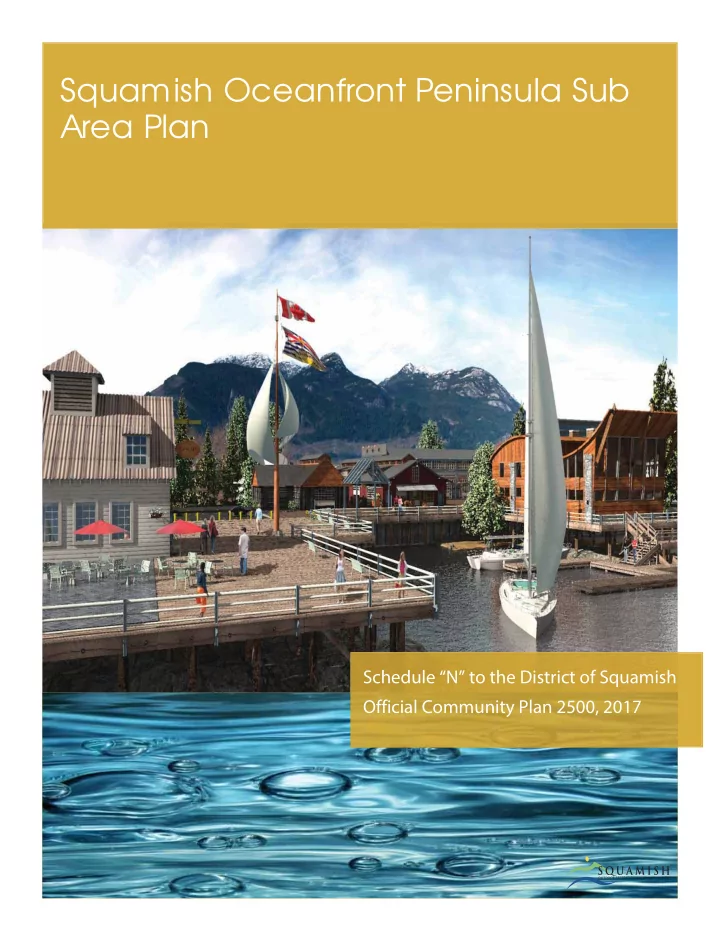
5.2.1.1 T he Villa g e Ce ntre
The Village Centre will provide a mix of pubs and patios, shops and boutiques, arts facilities, entertainment and dining combined in clusters to create a blend of village neighborhoods. One bleeds into the next, eventually connecting to a scenic marina sheltered along the edge. The Village Centre introduces a distinctive architecture that fuses the natural, the industrial and the creative into one. The village equally becomes a collage of locals and visitors attracting the full range of personalities that frequent the
play area, market stands and unforgettable West Coast dining - it’s a place where anyone can wander a day away. But unlike other settings of its kind, targeted to tourists, many of the social hubs for Squamish locals are found here - from that pub where people gather after work, study or play to everyone’s favorite restaurant for special occasions.
27
District of Squamish
5.2.1.2 Ma rine Se rvic e s
Marine Services will feature a fully integrated collection of businesses for chartering, outfjtting, training on, brokering, building, repairing and maintaining marine vessels. It has deep-water access at the south end to allow easy access for vessels of all sizes. In addition to providing employment, its location also allows it to be a visual and sound bufger between the rest of the Oceanfront and Squamish Terminals.
5.2.1.3 Prima ry E mplo yme nt
A diverse neighbourhood combines a montage of industries from light manufacturers, to entrepreneurs, to creatives. Here is an opportunity for iconic and inspiring companies to anchor the professional community and feed a culture
This will be the lifeblood of the Oceanfront peninsula and be an asset to all of Squamish. It provides local employment and economic stimulus. It creates work-near-home options in place of a bedroom community. It adds depth to the play activities seen on the site, by including services and creations to sustain these activities. As the Oceanfront develops and word spreads about this unique community, larger employers will begin to take notice and locate offjces here to take advantage of the local, highly skilled workforce.
5.2.1.4 E duc a tio n a nd I nstitutio ns
This neighbourhood will help meet the future educational and institutional needs of Squamish. It ofgers a great location to provide a range of outdoor, environmental and fjne arts programs along with a traditional post-secondary
a strong employment base for Squamish as well as educational opportunities for local and visiting students.
5.2.1.5 Pa rks a nd Pub lic Spa c e s
The Parks and Public Spaces will be the defjning character in this community and, are destined to become Squamish’s most treasured public amenities. They are the destinations for families to spend a summer’s day and the place for residents to come for a tranquil stroll, enjoy a picnic on the beach or participate in a unique festival or concert. The
to the Oceanfront Park and Beach, the Pier, the Lands’ End Monument and the Oceanfront Walkway, which encircles and connects the entire Oceanfront community.
28
Squamish Oceanfront Peninsula Sub Area Plan
5.2.1.6 Ne ig hb o urho o d Co mme rc ia l De stina tio ns
The Neighbourhood Commercial Destinations provide a small cluster of retail and commercial services for the surrounding neighbourhoods. Nearby residents and workers can fjnd a social gathering spot and place to fjnd needed provisions within an easy walking distance from their home or workplace on the Oceanfront.
5.2.1.7 Civic Use
When complete, the Oceanfront community will have a population of 2,500 – 3,000 residents and employees. A Civic Use area will be a valuable amenity and asset for the Oceanfront and all the residents of Squamish. Here we can fjnd a fmexible use community amenity facility, a performing arts facility and other civic uses near the center of the peninsula that are close to the core residential areas, the education and institutions, and within easy walking distance
5.2.1.8 Re side ntia l
Housing on the Oceanfront has been carefully planned to balance the success of the community but not to dominate the land. Diverse residential neighbourhood takes advantage of the waterfront to maximize value and the living
all drawn to the active lifestyle of the region as well as the unique energy and culture the Oceanfront community
Pie r
The Pier presents another opportunity to create a striking feature and draw for the Oceanfront. Some of the most visited and memorable waterfront and oceanfront destinations have pedestrian piers. The simple reason for their success is that people are drawn instinctively to the water. With the spectacular setting in Howe Sound, surrounded by magnifjcent mountain ranges the end of this Pier will be the essence of the Sea to Sky experience.
5.2.1.9 Oc e a nfro nt Wa lkwa y (Blue Do tte d L ine )
The Oceanfront Walkway encircles the peninsula providing pedestrians and cyclists with a unique water and
experience winding its way beside the water’s edge through the forest and landscape. Arriving at Oceanfront Park the views of Howe Sound open up and vibrant activity on both land and water surround you. As it heads down through the Village Centre and along the Mamquam Blind Channel, the Oceanfront Walkway becomes a lively waterfront boardwalk. The Oceanfront Walkway winds throughout the peninsula and beyond, creating pedestrian access to the Estuary and connecting the entire community including downtown Squamish.
29
District of Squamish
5.2.1.10 Pe de stria n Wa lkwa ys (L ig ht Gre e n Do tte d L ine )
Contained within the Oceanfront community, webs of pedestrian and cycling trails connect playing and working to living and learning. Follow these trails and you will be led easily through the community with discovery at every step.
5.2.1.11 Ma rina s
The redevelopment of the Oceanfront peninsula provides the opportunity to create protected marinas on the East and South edges of the peninsula. The Marinas can also provide animation and a customer base for the Village Centre and the Marine Services, as well as providing the fmoating infrastructure integral to a cruise ship terminal and the pedestrian pier experience.
5.2.1.12 Ma jo r F
a ndsc a pe I c o ns
A key planning principle is to develop attractive visual markers and beacons for visitors and residents approaching the Oceanfront peninsula from any direction, and in any mode of transport. Locations have been selected where views terminate to provide strong directional markers as you move through the peninsula. The two most important focal points are the Cleveland Avenue entry to the peninsula and the Lands’ End Monument at the southern point of Oceanfront Park.
5.2.1.13 Ma jo r Pub lic Vie ws
The plan was designed with public views in mind. Virtually all roads are open to views to the end, and the entry to the peninsula opens to a powerful view of the Chief and Shannon Falls over Galbraith Park.
5.2.1.14 Ma in Ac c e ss Ro a d (Da rk Ora ng e L ine s)
The main entry to the Oceanfront peninsula will start at the southern end of Cleveland Avenue as you leave
control the intersection at Cleveland and Vancouver, and also serve as the entry statement/feature for the Oceanfront
leg will allow vehicles to use a 2nd Access Bridge over to 3rd Avenue and the Estuary. These roads provide primary access for all landowners on the Oceanfront peninsula.
5.2.1.15 L
ig ht Ora ng e L ine s)
There are several secondary access roads that will access parcels ofg the Main Access Road.
30
Squamish Oceanfront Peninsula Sub Area Plan
5.3 L a nd Use Pla n
Land use policies address the spatial arrangement of a range of land uses on the Oceanfront, from living to working to recreation playing and learning, by controlling the types of uses that can be developed. The main types of uses include employment, commercial, public open space, community facilities and housing. The Oceanfront will be developed as a model of smart growth development. It will be compact, transit-friendly and include a diverse mix of uses to support working, learning and recreation, and living. To avoid becoming a bedroom community, Squamish will plan the Oceanfront peninsula to provide a good balance of jobs and housing as well as strong recreational and cultural facilities.. The mix of uses will complement and strengthen the existing Squamish downtown area, and contribute to a healthy mix of uses in the District of Squamish as a whole. Each major phase of development should include a variety of uses aimed at achieving suffjcient critical mass for success. The plan will take full advantage of the unique location and waterfront aspects of the peninsula. The form of buildings (height, shape, and character) is related to, but difgerent from their use, and is addressed in the Buildings and Built Form section. Figure 12 - Howe Sound Figure 13 - Local Scenery
31
District of Squamish
5.3.1 Ge ne ra l Ob je c tive s
Refmecting the Oceanfront Guiding Principles, policies in this section will work together to:
and quality public spaces;
32
Squamish Oceanfront Peninsula Sub Area Plan Substantial progress has been made to clarify the right mix and intensity of uses for the Oceanfront. Nevertheless, an objective of this policy is to achieve community goals within a fmexible framework, recognizing that community needs, market realities, and the understanding of what is best will change over the 20-40 year build-out period. General Policies
Buildings and Built Form;
the exceptions enhance the intent of the proposed land-use;
predominantly residential areas may still have small local commercial components, and employment areas may similarly have small-scale supporting services.
5.3.2 Villa g e Ce ntre
The Village Centre, located on the southeast corner of the Oceanfront, will be a hallmark feature of the Oceanfront. It will provide a true waterfront village experience that Squamish deserves to celebrate its identity as an
locate the Village Centre close to the ocean and give it true waterfront character. Being adjacent to the Oceanfront Park will both benefjt from and animate the core social gathering area in the development. The Village Centre should be designed as a compliment rather than a competitor to the Downtown area of Squamish. Accordingly, it should be sized to provide suffjcient critical mass for success, and yet not be overwhelming in its replace drawing commercial ofgering or in its massing or density. Overall this area should not exceed 90,000 square feet of buildable. The architectural style should be intentionally diverse to give it authenticity and character. There should be a focus on entertainment based food and beverage, and retail and only provide those services necessary to support the resident and employee community on the Oceanfront peninsula. The plan should contemplate a true waterfront marine/boardwalk edge so as to allow the buildings and activity of the Village Centre to spill towards the water and marina. The Village Commons should be a community gathering spot and the magnetic center for the convergence of
employment areas. All-important events can have a temporary home here in the Village Commons so it can become known as the place to arrive and meet when coming to the Oceanfront
5.3.2.1 Ob je c tive s
Figure 15- Village Centre
33
District of Squamish
5.3.2.2 Po lic ie s
Maximum permitted density in the Village Centre area is 2.50 FAR;
5.3.2.2.1 5.3.2.2.2
Permitted Uses in the Village Centre include retail, service, entertainment, cultural, marine, civic and tourism accommodation that are intended to serve the needs of both local residents and tourists;
5.3.2.2.3
Tourist accommodations may be in the form of hotels, condo-hotels and Bed and Breakfasts;
5.3.2.2.4
Commercial uses are required at grade facing all public spaces;
5.3.2.2.5
Encourage the use of patios and outdoor eating areas for food and beverage uses, to meet local retail and service needs, to create a draw, and to enliven public spaces;
5.3.2.2.6
Retail uses and services should contribute to a lively mix of uses and support the “richness of experience” desired by residents and visitors alike;
5.3.2.2.7
Encourage a lively nighttime area and use through an appropriate mix of restaurants, pubs and entertainment uses;
5.3.2.2.8
Focus on smaller scale commercial spaces to reinforce the essential character of the Village Centre as a small scale waterfront commercial village;
5.3.2.2.9
Encourage distinct commercial sub-neighbourhoods to provide a variety of themes and experiences;
5.3.2.2.10
Provide an appropriate space for a buskers, displays, outdoor markets and other temporary activities in the Village Commons;
5.3.2.2.11
Design public spaces with consideration for weather protection, including consideration of covered or enclosed outdoor spaces;
5.3.2.2.12
Encourage development to face east away from the prevailing winds and afgord the dramatic views up to the Chief and Shannon Falls;
5.3.2.2.13
Provide direct linkages between the Village Centre and any alternate transportation modes such as ferries and vertical transportation links;
5.3.2.2.14
Accessory residential, commercial or offjce uses are permitted above the ground fmoor if they are compatible with the commercial uses that are the primary use focus of the area;
5.3.2.2.15
Ground fmoor offjces and commercial uses that do not generate signifjcant pedestrian traffjc or enliven the public realm are discouraged from locating on the ground fmoor in the Village Centre;
5.3.2.2.16
Encourage innovative parking and transportation standards to create a more pedestrian oriented environment; and
5.3.2.2.17
Encourage a location and use for First Nations presence.
34
Squamish Oceanfront Peninsula Sub Area Plan
5.3.3 Wa te rfro nt E mplo yme nt 5.3.3.1 Ob je c tive s
A major asset of the Oceanfront is its deep- water access. Land uses should support continued use of this asset, and take advantage of it to draw marine activity, tourists, and local businesses. This area provides for a low impact environmental industrial use that can allow great marine access for all sized vessels and can complement and serve the marina activity on the south and east shores of the peninsula. It can provide large open space for transport and storage. A large boat ramp can be built at the south end accessing deep water. It provides a great complimentary use to the Squamish Terminals on the opposite side of the channel. This use may also not require extensive fmood level protection allowing the area to drop in elevation below the other development areas therefore, visually shielding some of this more light industrial activity. Prior to fjnalizing the zoning for this parcel, it would be prudent to explore having the fmexibility to allow an expanded list of light industrial uses to complement marine activity. In addition, some residential multi-unit developments at the northern portion of the area adjacent to the Education and Institution area may be appropriate, should the primary Marine Employment use not be suffjcient for the entire area. The Marine Employment area also includes an area for community use with the Performing Arts Centre and the Arts Studio. Figure 16- Waterfront Employment
5.3.3.2 Po lic ie s
Maximum permitted density is 1.75 FAR in the Waterfront Employment area;
5.3.3.2.1 5.3.3.2.2
Permitted Uses include boat building, leasing, sales and repair, small-scale manufacture and other maritime-related and accessory uses are permitted in this area;
5.3.3.2.3
Permitted Uses such as community arts facilities related to arts and marine are permitted in this area;
5.3.3.2.4
Permitted Uses such as a duty free export distribution facility are permitted in this area;
5.3.3.2.5
Retail uses are permitted only if they are directly associated with other types of commercial marine
5.3.3.2.6
Offjce uses are permitted only if they are directly associated with the marine or light industrial uses;
35
District of Squamish Surface parking is permitted in this area;
5.3.3.2.7 5.3.3.2.8
Where possible public will be provided physical, or at least visual, access to the Marine Employment Area for parking, and to experience a working marine employment area;
5.3.3.2.9
Marine-related tourist and recreation uses such as tourist services, cruise ship terminals, marinas, rentals, public boat launching and related activities, are encouraged;
5.3.3.2.10
Provide public access to the boat launching facilities given operational requirements of businesses;
5.3.3.2.11
Accommodate potential use for passenger ferries, and for emergency use for vehicle ferries, if appropriate;
5.3.3.2.12
Residential uses above the ground fmoor may be considered if they are for caretakers, seasonal stafg,
present, residential uses must be located away from the Squamish Terminal, and must be bufgered from noise and light by intervening buildings; and,
5.3.3.2.13 Use of the water in this area should be generally associated with adjacent employment land use. 5.3.4.1 Ob je c tive s 5.3.4 Prima ry E mplo yme nt
This core employment area is located in the central portion of the southern end of the
working environment since it is close to the
recreational activity provided at the south end. These kinds of amenities are crucial competitive attributes if Squamish is going to be successful in attracting more professional, creative and knowledge class workers who will help build a new economic foundation for the community. The Primary Employment area shall provide for a wide variety of employment land uses such as light manufacture, some service commercial and retail, professional and business use and high technology. It will also be appropriate to allow for a limited amount
mixed-use or multi-unit residential use shall be limited to a maximum of 25% of the overall Primary Employment site area and be located so as to not negatively detract from the primary land use. Although there will be a wide range of employment use, it will be necessary to focus certain activities and uses within industry sectors to maintain the integrity and principles of the Sub Area Plan. Figure 17 - Primary Employment
36
Squamish Oceanfront Peninsula Sub Area Plan
5.3.4.2 Po lic ie s
Maximum permitted density is 1.5 FAR in the Primary Employment area;
5.3.4.2.1 5.3.4.2.2
Uses such light manufacture, professional and business offjce use and high technology offjce are permitted in this area;
5.3.4.2.3
Accessory residential uses are permitted above the ground fmoor if they are compatible with the employment uses that are the primary focus of the area;
5.3.4.2.4
Any light manufacturing use should front the Waterfront Employment area and shall not be permitted to discharge any odors, heat or vibration;
5.3.4.2.5
Retail and commercial service uses are permitted at the south end adjacent to the surface parking area, the Oceanfront Park and the Main Access Road. They must be located at grade level;
5.3.4.2.6
Encourage a small grocery store in this location, sized to service the peninsula; and daycare and child care uses are encouraged in the primary employment area;
5.3.4.2.7
Surface parking is permitted in this area subject to appropriate screening and landscaping.
5.3.5 Ma in Stre e t F le x Use 5.3.5.1 Ob je c tive s
This area provides a fmexible framework to extend the potential for pedestrian-oriented commercial and retail activity from the Village Centre along the Main Access Road to the Village Crossroads. On the west side these uses would be located on the ground level of the development facing the Main Access Road with professional employment uses on the levels above. On the east side there would be similar use at ground level with residential use above. The commercial fmex uses shall be an optional use rather than a required use to allow the primary use to take priority. Figure 18 - Main Street Flex Use
37
District of Squamish
5.3.5.2 Po lic ie s
Uses such as retail, entertainment, cultural, and tourist activities and services that serve the needs
as identifjed on Schedule G;
5.3.5.2.1 5.3.5.2.2
Commercial experience is themed to enhance the connection between the commercial village and the learning centre;
5.3.5.2.3
Any permitted commercial uses are required at grade facing all public spaces to meet local retail and service needs, to create a draw, and to enliven public spaces;
5.3.5.2.4
Encourage innovative parking and transportation standards to create a more pedestrian oriented environment.
5.3.6 E duc a tio n a nd I nstitutio ns 5.3.6.1 Ob je c tive s
The Education and Institutions area has been ideally positioned in the center of the Oceanfront peninsula. This provides an essential complimentary bridge between the main residential areas and the employment areas. It fronts on green space and the Cattermole Slough that lends itself well to a student or other similar campus environment. Students and stafg can easily walk to the south end where the Village Centre, employment areas and parks are situated, the main residential areas and downtown to the north, and the Civic Use area that is immediately adjacent. The size of this area is adequate to meet the future needs of the existing higher education facilities already serving or interested in serving Squamish as it expands and
social, recreational, student housing and commercial uses associated with a post-secondary educational or institution
accommodate residential land use, should the primary use, or some portion thereof, not be determined to be viable. Figure 19- Education and Institutions
38
Squamish Oceanfront Peninsula Sub Area Plan
5.3.6.2 Po lic ie s
Maximum permitted density is 1.75 FAR in Education and Institution area;
5.3.6.2.1 5.3.6.2.2
Uses such as universities, post-secondary education, technology institutions, private schools, and arts schools and accessory student or faculty housing are permitted;
5.3.6.2.3
Accessory uses such as commercial, recreational and cultural activities that support the primary education and institutional use are also permitted;
5.3.6.2.4
Any permitted commercial uses shall be located at grade and face public spaces where possible;
5.3.6.2.5
Surface and structured parking are permitted in this area, subject to appropriate screening and landscaping;
5.3.6.2.6
Encourage innovative parking and transportation standards to create a more pedestrian oriented environment; and
5.3.6.2.7
Permit shared parking facilities with adjacent Civic Use as described in section 5.4.10 and shown on Schedule H.
5.3.7 Ca tte rmo le Slo ug h F le x Use 5.3.7.1 Ob je c tive s
Along the western side of the peninsula along the Cattermole Slough in an area that is designated for Marine Services or Educational and Institutional, there exists an area that will have a fmexible zoning to incorporate possible residential use. The rationale is that depending on market demand, land availability,
Figure 20 - Cattermole Slough Flex Use
5.3.7.2 Po lic ie s
Any permitted residential use will be at the discretion of the District of Squamish;
5.3.7.2.1 5.3.7.2.2
Residential if permitted here will abide by similar policy to the Cattermole Waterfront Residential.
39
District of Squamish
5.3.8 Ca tte rmo le Wa te rfro nt Re side ntia l 5.3.8.1 Ob je c tive s
The western exposure along the Cattermole Slough is quiet, afgords shelter from the prevailing winds, has ample green space setbacks and yet still maintains a waterfront character to enhance residential value. The massing of this area provides for low density townhome development fronting the Cattermole Slough with some medium density condominiums situated closer to the Education and Institution area. The objective is to scale the massing and density away from the water edge to create a sensitive interface with the natural edge and maximize light and views for all the residential development behind. The location ofg the Main Access Road makes this area feel more “residential” in character. The primary land use for this neighbourhood shall allow for the use and construction of multi-unit residential buildings, which can range from condominiums and apartment buildings to attached townhouse dwellings. Figure 21- Cattermole Waterfront Residential
5.3.8.2 Po lic ie s
Maximum permitted density is 1.5 FAR in the Cattermole Waterfront Residential area;
5.3.8.2.1 5.3.8.2.2
Permitted Uses are Multi-unit residential in the form of four storey apartments and two and three storey townhouses. Single-detatched housing is not appropriate here;.
5.3.8.2.3
Daycare and other similar accessory neighbourhood service uses are also encouraged in the Cattermole Residential Area;
5.3.8.2.4
Maintain lower built forms close to the water so as to afgord views for developments located in the interior of the peninsula;
5.3.8.2.5
Create a less intensive development edge against the natural Cattermole Slough environment with physical and visual access to Cattermole Slough;
5.3.8.2.6
Support but do not mandate the ability to allow live-work units in the residential areas;
5.3.8.2.7
Provide underground or covered parking as opposed to surface parking. Encourage innovative parking and transportation standards to create a more pedestrian oriented and environmentally sensitive environment;
40
Squamish Oceanfront Peninsula Sub Area Plan
5.3.8.2.8
Encourage zoning innovation to allow for the inclusion of:
5.3.9.1 Ob je c tive s
Mamquam Waterfront Residential is envisioned to be a more urban waterfront neighbourhood that will be desirable as a result of the direct views towards the Chief and Shannon
Commercial areas in addition to the activity of a vibrant, more urban waterfront environment. It will provide ground-
in a variety of sizes massed along the Main Access Road. Certain condominiums and apartments in this location will be allowed to be taller so as to maintain density with reduced building footprints. This will preserve pedestrian and adjacent development view corridors. Figure 22- Mamquam Waterfront Residential
5.3.9.2 Po lic ie s
Maximum permitted density in the Mamquam Waterfront Residential area is 3.5 FAR;
5.3.9.2.1 5.3.9.2.2
Permitted Uses such as Multi-unit residential in the form of 4 to 12 storey condominiums and apartments and two and three storey townhouses. Single detached and duplex housing is not appropriate here;
5.3.9.2.3
Maintain lower built forms close to the water, with height stepping up from the water to afgord views for developments located in the interior of the peninsula;
5.3.9.2.4
Encourage the design of patios, plazas, courtyards and pedestrian areas that will help create an active and vibrant edge along the Mamquam Blind Chanel;
5.3.9.2.5
Ensure that the distribution of density reinforces a walkable community and encourages successful commercial enterprises by increasing density towards commercial/institutional nodes;
5.3.9.2.6
Support but do not mandate the ability to allow live-work units in the residential areas;
41
District of Squamish
5.3.9.2.7
Provide underground or covered parking for all residential development as opposed to surface
5.3.9.2.8
Encourage zoning innovation to allow for the inclusion of:
nte rio r Re side ntia l 5.3.10.1 Ob je c tive s
The Sub Area Plan has positioned this core residential area towards the north end of the site. This accomplishes several goals. It positions residential between the existing downtown area and the Oceanfront peninsula commercial and employment areas. This will encourage a live work relationship. The Education and Institution area bufgers the neighbourhood from the Oceanfront employment uses and the Squamish Terminals. The massing of the site provides low-density townhome development at the north end against the Westminster Right of Way and the entry park area. High-density condominiums are located in the balance of the area. This scales the massing and density towards the center of the peninsula and allows those developments to have view overlooks over or through the lower density developments along the Cattermole Slough. In addition the views to the east will be facilitated through the Galbraith Park area and other view corridors along the Mamquam Blind. The primary land use for this neighbourhood shall allow for the use and construction of multi-unit residential buildings, which can range from condominiums and apartment buildings to attached townhouse dwellings. Figure 23- Interior Residential
42
Squamish Oceanfront Peninsula Sub Area Plan
5.3.10.2 Po lic ie s
Maximum permitted density in the Interior Residential area is 2.5 FAR;
5.3.10.2.1 5.3.10.2.2
Permitted uses include Multi-unit residential;
5.3.10.2.3
Building forms will be four to six storey condominiums and apartments and two and three storey
5.3.10.2.4
Ensure that the distribution of density reinforces a walkable community and encourages successful commercial enterprises by increasing density towards commercial/institutional nodes;
5.3.10.2.5
At rezoning, the District may consider the use of amenity based zoning to create incentives for green development or other public amenities;
5.3.10.2.6
Support but do not mandate the ability to allow live-work units in the residential areas;
5.3.10.2.7
Provide underground or covered parking for all residential development. Encourage innovative parking and transportation standards to create a more pedestrian oriented and environmentally sensitive environment;
5.3.10.2.8
Encourage zoning innovation to allow for the inclusion of:
5.3.11.1 Ob je c tive s
There are two Neighbourhood Commercial areas planned for the Oceanfront that provide vibrant commercial gathering places for the north end of the
Road to optimize visibility and are within easy walking distance of all the new diagrams Residential, Education and Institution uses. The intent is to make these small consolidated compact areas that do not compete directly with either Downtown Squamish or the Village
experience,” to the neighbourhoods and provide a pedestrian oriented social centre. Figure 24- Neighbourhood Commercial
43
District of Squamish
5.3.11.2 Po lic ie s
Permitted Uses include local retail, entertainment, essential service activities that primarily serve the needs of the local residents and employees;
5.3.11.2.1 5.3.11.2.2
Commercial uses should be oriented to public spaces; to create a draw, and to enliven public spaces;
5.3.11.2.3
Encourage the use of patios and outdoor eating areas for food and beverage uses;
5.3.11.2.4
Small plazas, patios and courtyards open up to the street;
5.3.11.2.5
Buildings should be softened with plants and green edges; and,
5.3.11.2.6
Encourage innovative parking and transportation standards to create a more pedestrian oriented environment.
5.3.12 Ma rina s a nd Wa te rfro nt Struc ture s 5.3.12.1 Ob je c tive s
The water lot areas in the Oceanfront peninsula are envisioned to be used to reclaim land for the purpose of uses dealt with above, provide for marine structures and to host a variety of marine activities and uses. The majority of the proposed marina berths in the Sub Area Plan have been located in the Mamquam Blind Channel. This is a sheltered location that will provide activity and ambience critical to the success of the commercial activity on the Oceanfront peninsula. An additional area for marina berths can be accommodated at the south end of Oceanfront Park sheltered by the Pier. These marinas will likely provide a range of berths, marine tourist operators, short-term transient boats and long-term
large vessels, short term daily berths and for community Sailing Center use. This will also be the likely location for any ferries and water taxis that will link the Village Centre to other Squamish waterfront locations. These activities in the Salt Dock area can create signifjcant activity that will compliment and animate the Village Centre. The Sub Area Plan does not contemplate any signifjcant marine activity in the Cattermole Slough. The intent is to keep this for more natural and low impact marine activity like kayaking and canoes. The Cruise Ship Terminal is ideally located in a deep-water portion of the water lot ofg the Pier and adjacent to the Squamish Terminals. It will also compliment and help screen the industrial marine activity at the Squamish Terminals. The Pier itself should be a fmoating breakwater that also provides protection for the marina berths at the south end of Oceanfront Park. Figure 25- Marinas and Waterfront Structures
44
Squamish Oceanfront Peninsula Sub Area Plan The Pier presents another opportunity to create a striking community pedestrian feature. It is in a position where one can view all the water activity, up close. It afgords great views back to the beaches, parks and Village. It allows one to
around the Oceanfront. Yet, it has been stepped back so that it does not block the Howe Sound view from Oceanfront Park, the Village Centre and the Lands’ End Beacon. At key points along the Mamquam Blind Channel it will be appropriate to allow for some other waterfront structures like small piers, docks, commercial ferry terminal, and potentially some small commercial buildings built over the water, extending out from the Oceanfront Walkway. Figure 26 - Mamquam Blind Channel Marina Area The opportunity to reclaim land within water lot areas is available. Any reclaimed land should adhere to and be consistent with the goals and objectives of the Sub Area Plan, and:
5.3.12.2.1 5.3.12.2.2
Permitted Uses include marinas, piers, docks, (including accessory boat rentals, ferry, water taxis and charter operations) fmoating homes, retail, rentals and tourist activities; The upland portion of the water’s edge shall be publicly accessible;
5.3.12.2.3
Encourage the Mamquam Blind Channel as a vibrant mix of marine activity and animated public realm;
5.3.12.2.4
Ensure land use provides a safe environment for the range of marine activities that will take place in the Mamquam Blind Channel;
5.3.12.2.5 5.3.12.2.6 5.3.12.2 Po lic ie s
Ensure the south end of the peninsula balances the primary views and the natural setting with any marine activity and structures; Ensure any reclaimed land in water lots properly mitigates and compensates for any environmental impacts;
45
District of Squamish
5.3.12.2.7
Any future reclamation
development, other than that currently shown in the Sub Area Plan will require an amendment to the Sub Area Plan. The amendment should show:
peninsula would be adjusted to integrate the new land area;
Maintain the natural character along the Cattermole Slough edge and allow only low impact and small non-motorized watercraft;
5.3.12.2.9
Small watercraft launching and landing will be permitted in the Sailing Centre and Wind Sports Beach area at the south-east portion;
5.3.12.2.10
Uses such as fmoating homes will be explored along the Mamquam Blind as long as public access along the waterfront is not restricted, and appropriate services can be provided;
5.3.12.2.11
Commercial Uses are permitted along the Mamquam Blind channel;
5.3.12.2.12
Use for marine structures associated with cruise ship activity and terminals are permitted at the south end of the Oceanfront peninsula;
5.3.12.2.13
Dredging activity that is required to accommodate any of the above uses would be permitted;
5.3.12.2.14
Encourage innovative parking and transportation standards to create a more pedestrian oriented environment and shared parking use with other complimentary uses and activity; and,
5.3.12.2.15
Development along the Mamquam Blind Channel will provide landing location(s) for local water taxis. Figure 27 - Local Wildlife
46
Squamish Oceanfront Peninsula Sub Area Plan
5.4 Pa rks, Pub lic Spa c e s a nd Co mmunity F a c ilitie s
The Parks, Public Space, and Community Facilities at the Oceanfront enhance the livability of Squamish, create new habitat, draw people to the Ocean, and act as a gateway to Squamish for locals and visitors.
5.4.1 Ove ra ll Ob je c tive s 5.4.2 Po lic ie s
These policies apply to all parks and public open spaces, including street rights of way, and support the broad objectives for Parks, Public Spaces and Community Facilities.
5.4.2.1
By providing public parks, plazas, greenways and other open space as generally shown on Schedule H ( Parks, Public Spaces & Community Facilities Plan), including space for community and cultural facilities to ensure the highest possible quality of life;
5.4.2.2
Parks and Public Spaces shall be built in accordance with the Sustainability Objectives and Policies as set out in section 5.7;
5.4.2.3
Vegetated bufgers, intended to enhance the ecological health of the riparian or intertidal zone, will be provided in accordance with the requirements of the Riparian Area Regulation, municipal bylaws, or the Squamish Estuary Management Plan, as applicable;
5.4.2.4
The Oceanfront will include intertidal areas as a part of the parks space;
5.4.2.5
Parks will be used for rainwater management;
47
District of Squamish
5.4.2.6
Plant species that are resilient and need little irrigation to minimize or eliminate water demand and pesticide use, will be prioritized for use in public spaces;
5.4.2.7
The Squamish Estuary Management Plan is acknowledged and guides the management of estuary lands and the Squamish Oceanfront Peninsula;
5.4.2.8
The District will ensure a contiguous trail connection around the entire Oceanfront lands for pedestrian and cyclists;
5.4.2.9
The green network will coincide with the trail network and recreation staging areas and will foster connections to other trails and activities in the community;
5.4.2.10
Connection between parks and public spaces should be provided along pedestrian friendly street and crossings, and where appropriate between buildings via the trail network;
5.4.2.11
Parks will support alternative modes of transportation by providing facilities such as cycle racks;
5.4.2.12
Parks will be designed to meet the needs of a range of users, including children, youth, and seniors;
5.4.2.13
Parks will gracefully accommodate vehicles where appropriate;
5.4.2.14
Shelter for pedestrians from the wind will be provided through the size, shape, and design of public spaces;
5.4.2.15
Solar access to the public spaces should be optimized;
5.4.2.16
Public spaces (and associated public art) shall be designed to celebrate wind, rain, the ocean, the estuary, and other environmental infmuences;
5.4.2.17
Ensure public spaces have a visual connection with the natural environment, especially treasured near and distant viewpoints;
5.4.2.18
Provide signage and other educational opportunities relating to history and environment;
5.4.2.19
Maintain good night sky access and minimize light pollution to nearby wilderness areas, use full cut-
5.4.2.20
Reduce toxic materials in the environment, use landscape design and integrated pest manage to eliminate the use of pesticides and herbicides;
5.4.2.21
Encourage residents of multi-unit residential buildings access to initiate community gardens and utilize edible landscaping;
5.4.2.22
Parks will not be subject to formal foreshore protection to allow for soft edges;
48
Squamish Oceanfront Peninsula Sub Area Plan
5.4.2.23
Provide Washroom facilities for public use and in encouraged in public areas, park areas and within developments in multiple locations;
5.4.2.24
Include seating, amenities, and landscaping in Plazas to create spatial variety and interest.
5.4.2.25
Parks should be designed and constructed in accordance with Crime Prevention through Environmental Design (CPTED) principles and practices.
5.4.3 Oc e a nfro nt Be a c h a nd Pa rk 5.4.3.1 Ob je c tive s
The Oceanfront beach and park will provide a major destination draw at the south end of the peninsula that provides year-round access to the ocean for the entire community, and accommodates large events. It will celebrate and embody the wind and water that so strongly defjnes the oceanfront environment and will be designed to support major events such as festivals and wind sports competitions. The Beach will provide more sheltered access to the water for all of the community. A purpose built Windsports Beach will provide access for windsports enthusiasts while other beach areas will accommodate more passive and relaxed access to the ocean. It will be a place that provides year-round access to the ocean for the entire community.
5.4.3.2 Po lic ie s 5.4.3.2.1 Oceanfront Park will be Located generally as shown on Schedule H, the Parks Public Spaces and
Community Facilities Plan;
5.4.3.2.2 An accessible oceanfront walkway will be accommodated in a combination of permeable and non-
permeable surfaces for bikers and walkers;
5.4.3.2.3
Oceanfront Beach and Park should also accommodate everyday use for picnicking, bird watching, and other outdoor activities;
5.4.3.2.4
The park will be primarily soft landscaping, with parking and hard elements as necessary to support anticipated events and activities; Surface or structured parking will be provided adjacent to the Oceanfront Park;
5.4.3.2.5
Desirable features include: launch facilities for wind sports; areas to accommodate large festivals and events; an interactive kids’ play park; and elements that celebrate and are animated by ocean and wind;
5.4.3.2.6
The park should incorporate a sailing centre on the east side of the park with a ramp for sailing dinghies and paddle-powered boats;
5.4.3.2.7
49
District of Squamish Design of the park will consider habitat creation in the sub tidal and intertidal areas a priority;
5.4.3.2.8
Large structured sports fjelds/facilities are not contemplated for this area;
5.4.3.2.9
The park will also feature the “Lands’ End Monument” as a distinctive vertical architectural or public art element;
5.4.3.2.10 5.4.3.2.11 Desirable features include: gently sloping beach and elements that celebrate and are animated
by ocean and wind;
5.4.3.2.12
Landscaping and grading will be designed to calm winds on playgrounds and Village Commons;
5.4.3.2.13 Landscaping will include bio swales of native plants and grasses for wind protection and
habitat creation along the intertidal area. These are separated from each other to provide access to the beach; and
5.4.3.2.14 Creosote pilings will be removed or capped. 5.4.4 Villa g e Co mmo ns 5.4.4.1 Ob je c tive s
Situated within the Village Centre and bordered on three sides with a Hotel and commercial buildings with an open area to the Oceanfront Park. The Village Commons will be supported by a tremendous range of activities nearby, including maritime and offjce-based business, community recreation, arts, and culture, local shopping and services, a public marina, and residential. The Village Commons is intended to function as the central focus of activity and events on the
throughout the year.
5.4.4.2 Po lic ie s 5.4.4.2.1
The Village Commons shall be located generally as shown on Schedule H, the Parks Public Spaces and Community Facilities Plan;
5.4.4.2.2
The Village Commons should be designed as a highly fmexible space, supporting a wind protected location for outdoor concerts, informal kids’ play, people-watching, relaxation, patios for eating and drinking, markets and similar events, community and cultural displays;
5.4.4.2.3
The Village Commons will combine soft and hard landscape with furniture to encourage year- round uses and creates interest. It should be laid out and landscaped to protect users from dominant winds; and,
5.4.4.2.4
Streets surrounding the Village Commons should be permeable pavers or similar treatment, to promote a pedestrian environment.
50
Squamish Oceanfront Peninsula Sub Area Plan
5.4.5 Ga lb ra ith Pa rk 5.4.5.1 Ob je c tive s
Situated at the southern end of existing Galbraith Avenue, the street- end Galbraith Park ofgers expansive views of the Chief and Shannon
to preserve and frame those views for travelers along Galbraith, and to provide for local recreational needs of residents and workers.
5.4.5.2 Po lic ie s 5.4.5.2.1 Galbraith Park shall be located generally as shown on Schedule H, the Parks Public Spaces and Community
Facilities Plan;
5.4.5.2.2 The park will support the recreational needs of the surrounding area and will provide view corridors and
green space adjacent to the waterfront walkway;
5.4.5.2.3
The park will allow for the Oceanfront Walkway
5.4.5.2.4
Anticipated activities include informal viewing points, relaxation and contemplation for children and adults;
5.4.5.2.5
The park will be primarily soft landscaping, with hard elements as necessary to support anticipated events and activities; and,
5.4.5.2.6
The park will be designed with intertidal habitat as a priority.
5.4.6 Ca tte rmo le We tla nd 5.4.6.1 Ob je c tive s
Enhancing the wetland is intended to symbolize the strength of the link to the estuary beyond Cattermole Slough and refmect the importance of the natural environment to the Oceanfront. The objective is that this will become a fully functioning intertidal marsh restored from its industrial heritage. It may form part of any habitat enhancement required by the Squamish Estuary Management Program (SEMP).
5.4.6.2 Po lic ie s
The Cattermole Wetland shall be located generally as shown on Schedule H, the Parks Public Spaces and Community Facilities Plan;
5.4.6.2.2
The wetland will be a protected area and the focus of environmental education, and wildlife viewing and similar activities;
5.4.6.2.1
Figure 28 - Howe Sound
51
District of Squamish The park will be dominated by the wetland itself, with access limited to a boardwalk and perimeter trail;
5.4.6.2.4
The wetland will allow for the Oceanfront Walkway;
5.4.6.2.3 5.4.6.2.5
Human (and canine) entry to the wetland should be restricted through design, signage, and management not fences; and,
5.4.6.2.6
The wetland will have a pedestrian low scale bridge over an intertidal zone that will create an interface between the wetland and the brackish water in the Cattermole Slough.
5.4.7 Oc e a nfro nt Wa lkwa y a nd T ra ils 5.4.7.1 Ob je c tive s
A public waterfront walkway around the entire Oceanfront is a critical element of the Sub Area Plan, linking major public spaces, and connecting users to the human and natural history of the site. The interconnected trail network cuts through the other land uses running primarily East West at a number of locations across the site for the purpose of allowing users easily access facilities on either side of the peninsula.
5.4.7.2 Po lic ie s
A contiguous public access to the water and trail along the entire Oceanfront Walkway shall be provided and shall be located generally as shown on Schedule H, the Parks Public Spaces and Community Facilities Plan;
5.4.7.2.2
The walkway should be designed and constructed to support passive recreational activities and active transportation, including relaxation and contemplation, walking, cycling, and dog walking;
5.4.7.2.1
Figure 20 0 - Representati ive Waterfront t Illustration
The walkway should be designed with a range of characteristics. The east will generally be urban edge, and the west side more natural;
5.4.7.2.4
The walkway need not support secondary activities such as rollerblading along its entire length;
5.4.7.2.3 5.4.7.2.5
Where marine-related business activities may confmict with recreational use, efgorts will be made to maintain a continuous walkway and ensure effjcient, safe use; including providing alternate bypass routes where necessary;
5.4.7.2.6
Trail sections are shown in the section plans;
5.4.7.2.7
Pursue opportunities to enhance habitat along the full length of the waterfront using Green Shores as a guideline; Figure 29- Representative Waterfront Illustration
52
Squamish Oceanfront Peninsula Sub Area Plan
5.4.7.2.8
Link the waterfront walkway with the larger system of trails throughout Squamish;
5.4.7.2.9
Punctuate the Oceanfront Walkway with points of interest, from viewpoints to activity centers, and provide a variety of experiences and character along its length;
5.4.7.2.10
Enhance the interpretive nature of the Oceanfront Walkway by adding signage about both historical and natural features; and,
5.4.7.2.11
Celebrate “Mile Zero” of the Sea to Sky Trail, at the south end of the walkway.
5.4.8 Oc e a nfro nt Pie r 5.4.8.1 Ob je c tive s
The Objective of the pier is to provide access for pedestrians out onto Howe Sound while providing a large vessel dock and protected marina, should such infrastructure be desired.
5.4.8.2 Po lic ie s
The Oceanfront Pier shall be located generally as shown on Schedule H, the Parks Public Spaces and Community Facilities Plan;
5.4.8.2.2
The Pier must be open to the public at all times with the exception of loading and unloading registered cruise ships;
5.4.8.2.1
The Pier will be built on environmentally responsible pilings for the portion required for the cruise ship services. The portion beyond will be a fmoating structure;
5.4.8.2.4
The pier must provide access to the water via ladders or other means to ensure exit from the water;
5.4.8.2.3 5.4.8.2.5
Pier design will be reviewed by Squamish Estuary Review Committee;
5.4.8.2.6
Pier design must enable docking of large scale cruise ships;
5.4.8.2.7
All Pier design must work in conjunction with Squamish Terminals and any proposed marina uses;
5.4.9 Wa te r 5.4.9.1 Ob je c tive s
Water surrounds the Oceanfront and is a defjning feature and amenity; it also functions as part of the larger ecosystem, and is an important part of Squamish’s marine commercial and recreational
boundary will support ecological, recreational, and commercial uses of adjacent waterways. Figure 30- Representative Waterfront Illustration
53
District of Squamish
5.4.9.2 Po lic ie s
To support public recreational use of the ocean, provide docks, launches and related access points;
5.4.9.2.2
To acknowledge and respect the importance of Squamish Terminals and related marine activities, ensure that water-based activities are planned and located so they do not interfere with effjcient Terminal operations;
5.4.9.2.1
Recognize the importance of private business use of the water, and support it in the context of a working harbour. Such use may include ferries, marinas, and other uses that are compatible with nearby land uses;
5.4.9.2.4
Enhance intertidal and marine habitat in keeping with requirements under the Squamish Estuary Management Plan and in collaboration with the SERC; and,
5.4.9.2.3 5.4.10 Civic Use 5.4.10.1 Ob je c tive s
The Oceanfront will be an amenity-rich environment, meeting Squamish’s high expectations of community benefjts from development. As a part of a model sustainable community, civic and community facilities and services on the Oceanfront will provide the District of Squamish community with recreational, cultural, and social opportunities while at the same time, they will meet the needs of people who live and work there. There is an opportunity to use these facilities to lead and complement sustainability principles, and practices. The primary Civic use area is near the center of the peninsula, close to the core residential areas, the education and institution area, and within easy walking distance of the Village Centre and the other commercial areas. This area envisions a community amenities facility and a separate facility(s) for other Civic use. Parking could be shared with the neighbouring Education and Institution use. A small community Sailing Center or Beach facility for storage, club and rental activities can be located near the Wind sports Beach. It will have a drive to boat launch area, a small temporary parking area and washrooms. Figure 31- Howe Sound
54
Squamish Oceanfront Peninsula Sub Area Plan
5.4.10.2 Po lic ie s
The Sailing Centre, Performing Arts Centre and Arts Workshop, and Community Amenity Centre and separate Civic Facility shall be located generally as shown on Schedule G, the Land Use Plan;
5.4.10.2.2
Notwithstanding the location identifjed on schedule G, the performing Arts Centre may also be located in the Village Centre or Oceanfront Beach and Park area;
5.4.10.2.1
The maximum permitted density is 1.75 FAR for Civic Use;
5.4.10.2.4
Consider the following community-wide uses, regionally signifjcant facilities as initial priorities and accommodate them in the Oceanfront:
5.4.10.2.5
When deciding what initial priorities and/or other civic and community facilities to provide, and how they are designed, consider the following principles:
Locate civic and community facilities in or very close to commercial and institutional nodes to act as anchors and contribute to the active nature of these centers;
5.4.10.2.7
Develop civic and community uses in tandem with other development uses to ensure residents and employees have access to facilities appropriate to their needs;
5.4.10.2.8
Disperse facilities through the peninsula: do not co-locate them all;
5.4.10.2.9
To the extent possible, allow for the Arts Community to use the blue warehouse facility;
5.4.10.2.10 Encourage mixed-use facilities, in which community uses are combined with other users such as
private businesses, residential or institutions. Look for complementary uses where participation would strengthen the business case for each partner; and,
5.4.10.2.11 Surface parking shall be permitted and should look to share use with neighbouring uses.
55
District of Squamish
5.5 Building s a nd Built F
Building heights, location, character, and their relationship to public spaces are the subject of this section. The Oceanfront is a spectacular place with a unique marine character. Buildings on the Oceanfront need to refmect this character and beauty, and capture and extend Squamish’s sense of self. Buildings can go beyond responding to local conditions to actually celebrate the wind, rain and views, and their overall form can also create a strong sense of place. The community of Squamish has indicated that there is strong support for high environmental performance for
as a whole and a balance between building a thriving dynamic living, playing and working environment and supporting other community objectives. It has embraced the goal to provide certain areas with “small town character” , provide strong diverse architecture, maintain sensitivity to the relationships with natural features and amenities, and
a mechanism to enhance the ability of the Oceanfront peninsula to provide a strong array of community amenities, assets and benefjts. Strong planning rationale has been employed to optimize the location of these specifjc more dense forms. While some policy directions have been defjned for buildings, an objective of this policy is to achieve community goals within a fmexible framework, recognizing that community needs, market realities, and the understanding of what is best may change over the 20-40 year build-out period.
5.5.1 Ge ne ra l Ob je c tive s
Refmecting the Oceanfront Guiding Principles, policies in this section will work together to:
56
Squamish Oceanfront Peninsula Sub Area Plan
5.5.2 He ig ht, De nsity a nd Ma ssing
Figure 32- Building Massing Rendering
5.5.2.1 Ob je c tive s
These policies are established to:
that portion of the site on which it is shown on the Plan, and the total density on the site shall not exceed the average
In general, buildings should be massed to enhance passive solar heating and passive ventilation.
5.5.2.2 Po lic ie s
Maximum permitted building heights will be in accordance with Schedule I;
5.5.2.2.2
Buildings exceeding 6 stories will only be considered subject to the District’s ability to provide appropriate fjre fjghting response;
5.5.2.2.1
In areas designated for buildings two stories or less, the following guidelines apply:
5.5.2.2.4
In areas designated for buildings three storey’s or less, the following guidelines apply: Preferred building forms are:
57
District of Squamish
5.5.2.2.5
In areas designated for buildings of 4 storeys or less, the following guidelines apply: Preferred building forms are:
In areas designated for buildings of 6 storeys or less, the following guidelines apply: Preferred building forms are:
In areas designated for buildings 12 storeys or less, the following guidelines apply:
de ntity
An objective of the Sub Area Plan is to develop coherent guidelines for building character as part of the detailed planning and design
be an authentic refmection of the Squamish community and the unique aspects of the Oceanfront. A diverse architectural character is preferred to a unifying theme.
5.5.3.1 Ob je c tive s
Figure 33- Oceanfront Village Rendering
58
Squamish Oceanfront Peninsula Sub Area Plan
5.5.3.2 Po lic ie s 5.5.3.2.1 Buildings should contribute to
the establishment of an authentic Squamish vernacular that will create a unique neighbourhood expression:
along the waterfront edges, particularly for the lower height buildings and structures.
character for the interior areas and for taller structures.
Access Roads, the facade of buildings should be articulated to create intervals that maintain a small- town feel by refmecting historical building types and scales.
5.5.3.2.2
Through building massing and design, buildings should respond to and celebrate key environmental infmuences:
5.5.3.2.3
Consider iconic building design in landmark locations. Design of these buildings may depart somewhat from that typifjed by Oceanfront character guidelines, but must complement them and reinforce their intent;
5.5.3.2.4
Through building form and sitting, and the pattern of blocks and streets, maintain key public views and enhance the public experience of dominant surrounding landforms.
5.5.3.2.5
Require or encourage:
Figure 34- Representative Waterfront Illustration
59
District of Squamish
5.5.4.2 Po lic ie s
Frame streets and plazas with buildings at a comfortable scale for pedestrians, appropriate to the width of the public
with taller buildings set back above that height to maintain a consistent street wall. Ensure private and public spaces are clearly distinguished, and that transitions between them are well managed; and,
5.5.4.2.2
Ensure solar access to streets and most importantly to key parks and public open spaces. Limit shading between 10 am and 2 pm between spring and fall equinoxes.
5.5.4.2.1 5.5.5 Site L a ndsc a ping 5.5.5.1 Ob je c tive s
Site landscaping should be sensitive to environmental goals and contribute to the character of the Oceanfront peninsula.
5.5.5.2 Po lic ie s 5.5.5.2.1
Native plant species are preferred, and particularly those that complement the adjacent estuarine environment;
5.5.5.2.2
To create safe spaces, support the principles of Crime Prevention Through Environmental Design (CPTED) without compromising other policy objectives;
5.5.5.2.3
Design landscaping to provide habitat for birds, small mammals, and where appropriate, fjsh. Ensure that it is “bear-aware” and use native plants wherever possible;
5.5.5.2.4
Eliminate the use of pesticides and herbicides through landscape design and Integrated Pest Management approaches; and,
5.5.5.2.5
Encourage signifjcant amounts of interesting landscaping; Discourage landscaping that completely blocks views of private space from public space;
5.5.5.2.6
Encourage development of gardening opportunities for residents and businesses, including shared and patio or balcony gardens. Consider potential for the use of green roofs for gardening.
5.5.5.2.7 5.5.4 Building a nd Pub lic Re a lm 5.5.4.1 Ob je c tive s
It is important to maintain pedestrian friendly relationships with all building forms at the public interface. Figure 35- Representative Pedestrian Walkway
60
Squamish Oceanfront Peninsula Sub Area Plan
5.6.1 Ob je c tive s
The Oceanfront access and circulation plan objectives are as follows:
through the Downtown Squamish 2031 Transportation Plan;
emergency vehicles as required;
parking while balancing the need for parking
5.6 Ac c e ss a nd Circ ula tio n
61
District of Squamish Cycling and walking trails will be arranged as generally described on Schedules K and L Cycling and walking trails will connect to other trails and community amenities in Squamish; Walking and Cycling gateways will be established on the trail network to act as gathering points for the start of walks or bicycle excursions; Safe pedestrian walking and cycling cross walks will be indicated at intersections, trail heads, and areas of the Oceanfront Walkway that interact with other uses such as marine boat launching; Walking and cycling priority will be demonstrated at the Oceanfront with bike lanes and sidewalks
The District will explore separated or protected bike lanes as appropriate. Pedestrians will have reasonable spaced outdoor furniture and appropriate lighting for safe travel; Walking trails will be constructed in an accessible manner to promote use by all residents of Squamish; Employment and civic uses are encouraged to have end of trip facilities or alternatives to support alternative transportation such as cycle racks, lockers and showers; Layout and signage will allow for various users’ needs and abilities to fjnd their way around the Oceanfront; and, Storm drains or other municipal service access points will be fmush with road surfaces to minimize safety hazards for cyclists. Any grates will not have openings wider than 15 mm and will be placed perpendicular to traffjc fmow.
5.6.2 Wa lking a nd Cyc ling Po lic ie s 5.6.2.1 5.6.2.2 5.6.2.3 5.6.2.4 5.6.2.5 5.6.2.6 5.6.2.7 5.6.2.8 5.6.2.9 5.6.2.10 5.6.2.11
62
Squamish Oceanfront Peninsula Sub Area Plan
5.6.3 Pub lic T ra nsit Po lic ie s
Work with BC Transit to ensure that the Oceanfront is well served by transit which is an essential component to achieving the sustainability objective of reducing dependency on the private automobile; Land owners and business owners will work with the District to explore more convenient public transportation for regional commuting; Ensure that transit system is designed such that all of the Oceanfront residents and workers are within a fjve minute walk of a transit stop; Development along the Mamquam Blind Channel will consider docking locations for a local water taxi service. Transit stops will have appropriate curbs, shelter and seating; Cycling and walking trails will be coordinated with Transit stops; and,
5.6.4 Ro a d Ac c e ss a nd Circ ula tio n Po lic ie s
Primary Road access will be via Cleveland Avenue per Schedule J, the Circulation Plan; Secondary Road access will be via a bridge over the Cattermole Slough to 3rd Avenue generally as per Schedule J, the Circulation Plan; Before the fjnal secondary access is complete, a temporary secondary access will be considered from Loggers lane through a temporary right of way as identifjed on the Access and Circulation Plan to provide safe and direct access points to the neighbourhood that permit effjcient circulation
5.6.3.1 5.6.3.2 5.6.3.3 5.6.3.4 5.6.3.5 5.6.3.6 5.6.4.1 5.6.4.2 5.6.4.3
63
District of Squamish Development standards consistent with the Smart Growth on the Ground planning principles will be applied, specifjcally in the design and construction of the streets; Private roads to access development parcels will be permitted; The District should ensure Site access and ofg-site road systems are upgraded where necessary to accommodate the build out of the Oceanfront; Site design will minimize travel lane widths, reducing street crossing distances and vehicle speeds; and Schedules N-Q are conceptual only, but represent preferred cross sections, row width, and right of way widths.
5.6.4.4 5.6.4.5 5.6.4.6 5.6.4.7 5.6.4.8
64
Squamish Oceanfront Peninsula Sub Area Plan
5.6.5 Ma rine T ra nspo rta tio n Po lic ie s 5.6.5.1
Encourage the use of the Mamquam Blind Channel as a transportation corridor between the Oceanfront and Downtown Core;
5.6.5.2
Establish launching points for dinghy’s and non-motorized vessels;
5.6.5.3
Establish a separate launching point from dinghy launch for larger sail and power boats;
5.6.5.4
All marine related public transportation will be accessible and cyclist friendly; and,
5.6.5.5
Establish a plan to manage the interface and safety of boaters accessing marina’s and the Mamquam Blind Channel and other non-motorized vessels including kite boarders, wind surfers, sailors, kayakers, canoeists, etc.
65
District of Squamish
5.6.6 Pa rking Po lic ie s
Align parking policies for residential and commercial buildings with the District’s Squamish Downtown parking standards; On and ofg street parking will be provided generally as per the areas shown on Schedule S, the Parking Plan; Where parking demand varies over the course of the day or week for difgerent activities and land use, shared parking facilities are encouraged where proven feasible;
5.6.6.1 5.6.6.2 5.6.6.3
Developers will be encouraged to incorporate co-op car programs and parking stall sale programs to discourage car uses; The District will investigate a “small car bylaw” to reduce parking numbers.
5.6.6.4 5.6.6.5
66
Squamish Oceanfront Peninsula Sub Area Plan Multi-storied buildings will be encouraged to incorporate underground parking into the development applications; The District will explore parking arrangements that reward cooperatively owned vehicles and vehicles that emit fewer greenhouse gases; and Parking levels will be consistent with accessibility of the site by walking, cycling, and transit with the overriding objectives to reduce auto use.
5.6.6.6 5.6.6.7 5.6.6.8 5.6.6.9 5.6.6.10
Parking structures with one underground level and one street level parking lot will be investigated at the multilevel parking locations identifjed on the Parking Plan; The District will investigate the requirement for a larger structured parking lot at the Civic Use site if demand requires this additional parking in the future;
5.7 Susta ina b ility
The Squamish Oceanfront peninsula will be a community that embraces the principles of sustainable development. Identifjed as a key priority by the Squamish community in the Create the Oceanfront planning process, the policies in this Sub-Area Plan aim to achieve targeted goals for sustainability on the Oceanfront.
5.7.1 Ge ne ra l Ob je c tive s
The sustainability objectives for the Squamish Oceanfront are as follows: Protect, Enhance and Rehabilitate Natural Ecosystems – The Oceanfront development will focus on protecting, enhancing and rehabilitating ecological features for people, animals, and plants;
5.7.1.1
Foster Economic Development – The Oceanfront development will work to achieve the community driven goal of job creation at the Oceanfront important for community sustainability;
5.7.1.2
Aim for reduced Energy use and reduced GHG– The Oceanfront will endorse and support development plans for the District of Squamish Community Energy Action Plan. Support the District’s OCP and Downtown Transportation Plan by designing a community that prioritizes walking, cycling, transit and water-based transportation options over private single
5.7.1.3
Figure 36- Sailing on Howe Sound
67
District of Squamish Build Green Infrastructure and Green Development – The Oceanfront will adopt responsible development principles for building and neighborhood development. The Oceanfront will support “naturalized” storm water management and reduce potable water consumption through the use of low-fmow technologies. The Oceanfront will target “zero waste” and ensure SODC’s waste management strategies are aligned with the policy recommendations of the Squamish-Lillooet Regional District’s (SLRD) Solid Waste Management Plan (SWMP);
5.7.1.4
Focus on public open spaces and parks for community cohesion – Support a network of new and existing green spaces that are linked together through the Oceanfront and support ecological and diverse social functions. Honour the culture and heritage of Squamish through vistas, public art, recreational opportunities and park infrastructure;
5.7.1.5
Be sustainably focused on Land Use, Density & Site Layout – The Oceanfront will adhere to Smart Growth on the Ground Principles for mixed-use community design including criteria for neighborhood pattern and design; and,
5.7.1.6
Be accountable to the Community – The Oceanfront will create a dashboard of measurable indicators that allow the community to understand how the Oceanfront is doing against its sustainability targets.
5.7.1.7 5.7.2 E nviro nme nta l Susta ina b ility a nd Ha b ita t E nha nc e me nt 5.7.2.1 Ob je c tive s
Rehabilitating previously contaminated land and water - The Oceanfront land is the previous site of Nexen Chemicals. As such, the fjrst and most important, sustainability priority at the Oceanfront is completing the cleanup of the site for the use outlined in the Sub Area Plan. The Sub Area Plan also includes some fjll at the south end of the land. This fjll is a key tactic to rehabilitating the marine habitat at the Oceanfront Park. This rehabilitation and creation of new clean habitat will be reviewed as part of the environmental assessment process.
5.7.2.1.1
Figure 37- Representative Waterfront Illustration
68
Squamish Oceanfront Peninsula Sub Area Plan Creation and protection of sub-tidal habitat - Through the environmental review process for the rezoning
sits within the boundaries covered by the Sub Area Plan. Areas already considered for this are the base submarine portions of the Oceanfront Park, anchors and substructure of the Oceanfront Pier and other fmoating marine features. The focus here will be on creating intertidal or sub tidal rock reef (boulder, cobble) or other structures to encourage bladed kelp or red algae growth. Considered in the plan will be a hierarchy of preferences to avoid impacts on critically sensitive ecological features that should include the following;
5.7.2.1.2
Creation and protection of intertidal habitat - For salmon smolt, herring, and other fjsh and wildlife the intertidal areas are key habitat. The Sub Area Plan should follow the Green Shores Principles
the Cattermole Slough up to the area reserved for water access in the Marine Centre. This will include
the Cattermole Wetland partially intertidal to add diversity to the wetland habitat. One of the key tactics for the protection of this intertidal area is a low profjle bridge over the Cattermole Slough as
the removal of creosote pilings and hard vertical edges. On the Mamquam Blind Channel, with a more urban character, the intertidal area will consist of the most appropriate combination of habit benches
Oceanfront trail in this area will be a combination of boardwalks or vented cantilevered boardwalks.
5.7.2.1.3
69
District of Squamish Creation and protection of upland habitat - There are a number of opportunities for upland habitat creation in the plan. The Oceanfront Walkway allows for natural habitat and a healthy 25 meter riparian setback along the Cattermole Slough. The Oceanfront Park is about the community and access to the ocean but will have continuous pockets of natural habitat above high tide to shelter animals and people from the wind.
5.7.2.1.4 5.7.2.2 Po lic ie s
The following policies apply to the environmental sustainability of the Oceanfront Neighbourhood.
5.7.2.2.1
Protect, enhance and rehabilitate habitat at the Oceanfront;
5.7.2.2.2
Setback on the Cattermole slough should be no less than 20m from high tide mark;
5.7.2.2.3
Use Green Shores Principles as a guideline for water interface design;
5.7.2.2.4
Provide high quality terrestrial, riparian and marine habitat areas;
5.7.2.2.5
Limit motorized boat traffjc north of the Cattermole Bridge; Work with the Squamish Estuary Review Committee to develop a policy for grey water in any marina;
5.7.2.2.6
Establish an invasive species identifjcation, removal and replacement program;
5.7.2.2.7
Use landscape techniques that will reduce irrigation, harmful fertilizer, herbicide and pesticide use;
5.7.2.2.8
Utilize native plant species that are well suited to the regional climate and conditions in all parks, private yards and other landscapes where appropriate;
5.7.2.2.9
Create bio-swales in the Oceanfront Park and Beach between ocean access points to create biodiversity in the park;
5.7.2.2.10 5.7.2.2.11
Incorporate innovative storm water collection infjltration, retention and treatment systems;
5.7.2.2.12
Provide water use guidelines that will encourage sustainable and effjcient use of water resources;
5.7.2.2.13
Plant or improve vegetation bufgers between the light source and the shoreline to screen light from the shoreline; Figure 38- Representative Bike Board Walk Illustration
70
Squamish Oceanfront Peninsula Sub Area Plan
5.7.2.2.14
Angle outdoor lights downwards and away from shorelines
5.7.2.2.15
Initiate a program to replace creosote piles with more durable and less contaminated steel or concrete piles;
5.7.2.2.16
Review marina anchors as locations for sub-tidal reef locations for eco diversity;
5.7.2.2.17
Use remediation strategies as environmental habitat enhancement;
5.7.2.2.18
Designate the Cattermole Sough wetland as a natural marine zone;
5.7.2.2.19
Decommission the hard retaining walls in the Cattermole Slough and replace with soft shore designed foreshore;
5.7.2.2.20
Designate the portion of the Cattermole Sough north of the Cattermole Bridge a natural marine zone;
5.7.2.2.21
On the more urban edge of Mamquam Blind Channel, maintain the natural foreshore with sheet piling set back as far as possible in the intertidal zone and use piled or cantilevered boardwalks. Where the setback is not feasible, intertidal benches will be employed to maintain habitat; and,
5.7.2.2.22
All habitat design, park design, and foreshore protection will be reviewed by the appropriate government regulators for compliance to environmental standards.
5.7.3 E c o no mic Susta ina b ility 5.7.3.1 Ob je c tive s
A sustainable Squamish is a working Squamish. The feedback from the community indicated that a key motivation for the use of this land should be in the creation of long term well paid employment. There are number of ways that the Sub Area Plan works to achieve this goal. The plan calls for land use specifjc to employment use that should generate more than 2200 full time jobs in the professional employment sector, Marine Industry, Education, Retail and Tourism. It also results in thousands of person years of construction employment over the build out. Figure 39- Squamish Oceanfront Figure 40- Representative Pier Panorama illustration
71
District of Squamish
5.7.3.2 Po lic ie s
The following policies apply to the economic sustainability of the Squamish Oceanfront
5.7.3.2.1
The Oceanfront will pursue a balance between regulatory requirements and economic viability;
5.7.3.2.2
Provide a variety of commercial space types and sizes to provide growth options for business;
5.7.3.2.3
Enhance tourism expansion in the District of Squamish;
5.7.3.2.4
Enhance marine services expansion in the District of Squamish
5.7.3.2.5
Ensure that the target quality level of these new opportunities is coordinated with the economic development direction of the District of Squamish. Ensure the opportunity for Cruise Ship facilities are available if the District of Squamish requires this facility. Enhance educational business expansion in the District of Squamish;
5.7.3.2.7 5.7.3.2.6 5.7.3.2.8
Enhance the knowledge base industry and professional employment in the District of Squamish;
5.7.3.2.9
Provide an entertainment retail experience to assist with the economic development of the District of Squamish;
5.7.3.2.10
Provide the ability for high speed wireless internet services to the Oceanfront;
5.7.3.2.11
Ensure a compact or clustered development approach with a mix of uses to reduce servicing costs and long-term infrastructure maintenance costs that would be incurred by the District;
5.7.3.2.12
Provide post-development employment opportunities within the Oceanfront; The Oceanfront will look for ways to incent developers to build employment oriented facilities;
5.7.3.2.14 5.7.3.2.13
Incorporate energy effjcient design techniques where appropriate to reduce long-term energy and capital requirements of the Oceanfront; and,
5.7.3.2.15
Site preparation materials will be sourced locally, as much as possible. Figure 41- Representative Slough Panorama illustration
72
Squamish Oceanfront Peninsula Sub Area Plan
5.7.4 So c ia l Susta ina b ility 5.7.4.1 Ob je c tive s 5.7.4.1.1 Public Open Spaces and Parks - Parks and Open Spaces are critical for the health of a community. Small
spaces and big multiuse spaces to accommodate a wide variety of groups and gathering occasions have been made available at the Oceanfront. These parks and open spaces provide an opportunity to celebrate the past industrial heritage, the present physical majesty, and the future environmental goals of the District
playgrounds, windsports, picnicking, nature reserves, view preservation, water access, public art, historical education, natural education, cycling and walking.
5.7.4.1.2 Land Use, Density & Site Layout - The Oceanfront is part of planning for growth in the most sustainable
way in the District of Squamish. If the population is going to double in the next 15 to 20 years, compact neighbourhoods are part of the sustainable approach to growth. Compact neighbourhoods are a combination of residential and commercial use where walking is a viable option for transportation to all services required by the community to prosper over time. Increased walk ability of downtown Squamish through medium to high mixed-use density, the development of small city blocks on a grid pattern, the development of a pedestrian oriented streetscape with safe, wide sidewalks and greenways that connect neighborhoods to community amenities. The focus on compact neighbourhoods allows for community safety and allows for all demographics of the community to fjnd a home and the services to meet their needs.
5.7.4.1.3 Community Accountability - Sustainability for the Oceanfront has been defjned by the community through
the extensive public process that has occurred over the last 2 years. An objective of the Oceanfront should be to create a community dashboard that can demonstrate how closely the development is achieving the goals set out by the community. The District will need to determine how to set up and monitor the various components of the community dashboard.
73
District of Squamish
5.7.4.2 Po lic ie s
The following policies apply to the social sustainability of the Squamish Oceanfront:
5.7.4.2.1 5.7.4.2.2 5.7.4.2.3 5.7.4.2.4 5.7.4.2.5 5.7.4.2.7 5.7.4.2.6 5.7.4.2.8 5.7.4.2.9 5.7.4.2.10 5.7.4.2.11
Provide a variety of dwelling types, sizes and costs to accommodate a wide range of residents; Incorporate a variety of land uses including residential, commercial, light industrial, marine, educational, retail, open space and habitat; Foster a strong arts community at the Oceanfront; Create a dynamic and interesting public realm to foster social interaction gatherings, events, activities, recreation and refmection; Provide active and passive outdoor recreation opportunities and facilities for storage of recreation gear on site; Ensure accessibility to all groups interested in using the waterfront for activities that add to the vibrancy; Promote the availability of Daycare facilities and businesses; Ensure that a segment of housing is suitable for senior needs in the design; Utilize the Squamish Oceanfront as a catalyst to re-brand what it means to live in Squamish. Enhance the identity and vitality of the downtown area by increasing the core population; and, Incorporate the Dashboard into the public realm to monitor the Oceanfront’s progress in achieving its sustainability goals.
5.7.5 Built fo rm Susta ina b ility 5.7.5.1 Ob je c tive s 5.7.5.1.1
Energy use and GHG reductions Policies - The two places energy use and GHG reductions are primarily addressed are related to development and transportation. The Oceanfront supports the District of Squamish Community Energy Action Plan (CEAP) that has evolved as part of the Smart Growth on the Ground concept plan and changes in provincial legislation (bill 27-2008 - Green Communities). As signatories to the BC Climate Action Charter, Squamish will be required to report annually on steps taken to become carbon neutral by 2012. Incentives will be available for any developer that chooses to incorporate viable decentralized (building scale or nodal-scale) renewable energy sources where possible (geo-exchange, solar, wind, tidal, wave etc). Other more specifjc methods are outlined in the design guidelines but include: thermal property guidelines, solar guidelines, and utility monitoring guidelines.
74
Squamish Oceanfront Peninsula Sub Area Plan
5.7.5.1.2 Green Infrastructure and Development
Policies -The efgort with infrastructure and buildings is to reduce use and
broadly specifjed and specifjc green and sustainable building techniques are determined at the development permit stage for each development application to the satisfaction of District stafg. The following policies apply to Built Form Sustainability of the Squamish Oceanfront:
5.7.5.2 Po lic ie s 5.7.5.2.1
The Oceanfront will be built to take advantage of the District Energy/ NEU systems when they are available;
5.7.5.2.2 Develop in accordance with the
District of Squamish approved Smart Growth on the Ground and other approved policies;
5.7.5.2.3
Incorporate leading edge green and sustainable building strategies, including elements of LEED, Green Shores, and other future green design strategies that further the objectives of sustainability as defjned above, over the course of the project;
5.7.5.2.4
Incorporate design and construction technology to maximize energy effjciency, water conservation, and waste reduction;
5.7.5.2.5
The Oceanfront will target the provision of metering utilities for all uses. This will help to educate users on consumption; Reduce potable water use in residential and commercial/offjce buildings through the use of low- fmow fjxtures - such as, but not limited to, dual-fmush toilets, 1.5gpm showerheads, 0.9gpm sinks, 0.5gpm lavatories, waterless urinals and high effjciency front load washers; The development will incorporate storm water management processes into building design, streetscapes, parks, playgrounds and as landscaping. Example may include exposed pipes as part of park and playground designs, channeling water down the centre of streets, and fjltration through bio- swales or constructed wetlands;
5.7.5.2.7 5.7.5.2.6
Figure 42- Sun Setting over Howe Sound
75
District of Squamish
5.7.3.2.11 The Oceanfront will align with the policy
recommendations of the Squamish-Lillooet Regional District’s (SLRD) Solid Waste Management Plan (SWMP);
5.7.3.2.12 Provide facilities in all buildings to accommodate a private or municipal recycling program; 5.7.3.2.13
Three-stream waste separation (garbage, recycling and composting) to residents and businesses
collection services;
5.7.3.2.14
Reuse or recycle site resources and materials in order to reduce waste during construction; All Strata’s will be responsible for a user pay waste program that incorporates monitoring;
5.7.3.2.16 5.7.3.2.15
Contractors will use on-site recycling and disposal bins or recycle their own waste. Set aside an area of the job site to store salvaged building materials and house recycling bins; and,
5.7.3.2.17 Incorporate alternative development standards to minimize road widths and other hard
infrastructure.
5.7.5.2.8
Minimize impervious surfaces wherever possible;
5.7.5.2.9
Incorporate innovative technologies to utilize alternative clean energy options and explore
renewable sources such as geothermal, solar and wind;
5.7.5.2.10 Contribute to achieving higher performance
standards in building effjciency while lessening environmental impacts. These initiatives may include: extensive use of glass to maximize natural illumination, building orientation, building insulation, sustainable roofjng technology and alternative clean energy options;
5.8 I nfra struc ture
This section deals with the usually unseen but essential systems that support a healthy community: water and sewer systems, energy, solid waste management, and storm water management. Each of these human systems interacts directly with the environment that supports the community, and the plan’s impacts on the physical environment are a second element of this section. Figure 43 - Howe Sound
76
Squamish Oceanfront Peninsula Sub Area Plan
5.8.1 Ge ne ra l Ob je c tive s
The general objectives of infrastructure at the Oceanfront are:
A more detailed site servicing summary, analysis, and capital cost estimate will be prepared once the District has completed their fjnal review and analysis of the Downtown Infrastructure capacity in order to address ofg-site sewer and water infrastructure upgrades. The general infrastructure plan is below.
77
District of Squamish
5.8.2 Ge o te c hnic a l a nd F lo o d Pro te c tio n 5.8.2.1 Ob je c tive s
Provide geotechnical and fmood protection measures recommended by a professional engineer, including engineered geotechnical site preparation, foreshore protection and fmood control elevation or acceptable equivalent. An example of the fmood level elevation is adjacent.
5.8.2.2 Po lic ie s
The following policies pertain to the geotechnical and fmood protection of the oceanfront:
5.8.2.2.1
All geotechnical design will be done to provincial building code standards;
5.8.2.2.2
Habitable elevation is estimated to be approximately El. 5.0m geodetic datum and will be fjnalized in the engineering design;
5.8.2.2.3
All foreshore protection will be in accordance and approval of the provincial authority and will adjust
5.8.2.2.4 5.8.2.2.5
Parking garages, storage, utility rooms and services may be below the habitable elevation; and, Foreshore protection should be designed using Green Shores Principles as a guideline.
78
Squamish Oceanfront Peninsula Sub Area Plan
5.8.3 Wa te r 5.8.3.1 Ge ne ra l Ob je c tive s
The general objectives for water services are to provide the water capacity for the Oceanfront in a manner that optimizes capital costs, long term maintenance costs and environmental impacts. The Water Service Plan is below.
5.8.3.2 Ge ne ra l Po lic ie s 5.8.3.2.1
The proposed water system will be capable of meeting the Oceanfront’s ultimate domestic and fjre protection needs estimated at 175 L/s and 225 L/s respectively;
5.8.3.2.2
On site water systems will be designed, upgraded, and expanded as required to meet the requirements of the development and will meet all regulatory guidelines;
5.8.3.2.3
The development will be serviced by ofg-site District operated water supply;
79
District of Squamish
5.8.3.2.5
No water infrastructure will be constructed outside of the foreshore protection;
5.8.3.2.4
Water system design will incorporate the principle of two positively charged loops to allow for redundancy and safety. This will be constructed in a phased approach;
5.8.3.2.6
Water service may be done above existing grade and covered for impact and weather protection
5.8.3.2.7
Investigate water supply design that conserves water and construction resources through infrastructure and planning;
5.8.3.2.8
Investigate high pressure systems to limit piping size to try and reduce the piping sizes for the water utility;
5.8.3.2.9
Explore the potential for water metering of individual residential and business units; and,
5.8.3.2.10
Develop an education plan to inform residents and tenants about the benefjts of conserving water and the opportunities to save water.
The following water system servicing policies apply:
5.8.3.3.1
The Oceanfront will have fjre safety infrastructure to meet District regulations;
5.8.3.3.2
No buildings will be permitted in excess of 12 storeys unless and until the District has the fjre fjghting capacity to combat fjres in those buildings in accordance with Worker’s Compensation Board requirements and best practices; and,
5.8.3.3.3
The Oceanfront will implement approved fjre protection plans on an interim basis prior to the fjnal water loops being completed, and post completion of the water system. Figure 44- Representative Stormwater Illustration
80
Squamish Oceanfront Peninsula Sub Area Plan
5.8.4 Sa nita ry a nd Se we r 5.8.4.1 Ge ne ra l Ob je c tive s
The general objectives for water services are to provide the water capacity for the Oceanfront in a manner that optimizes capital costs, long term maintenance costs and environmental impacts. The Water Service Plan is below.
5.8.4.2 Po lic ie s 5.8.4.2.1
The sanitary sewer system will meet the estimated design criteria of 175 L/s PWWF and have the capacity to vary fmow to deliver the average daily loading to the District Pump Station;
5.8.4.2.2
The proposed development will be serviced by ofg site sanitary treatment facilities operated by the District;
5.8.4.2.3
On site sanitary sewer systems will be designed, upgraded, and expanded as required to meet the requirements of the development and will meet all regulatory guidelines;
5.8.4.2.4
The Oceanfront Sanitary Sewer system will join District system at the current pumping station on Vancouver between 2nd Avenue and 3rd Avenue or other location designed by District and Oceanfront representatives;
5.8.4.2.5
No sanitary sewer infrastructure will be constructed outside of the foreshore protection;
5.8.4.2.6
Sanitary sewer service may be done above existing grade and covered for impact and weather protection
5.8.4.2.7
Investigate design that reduces waste through infrastructure and planning;
5.8.4.2.8
Investigate alternatives for PVC piping to limit infjltration and extend the life cycle of the equipment;
81
District of Squamish
5.8.4.2.9
Investigate high pressure systems to limit piping size to try and reduce the piping sizes for the sewer utility; and,
5.8.4.2.10
Explore the potential for sewer metering of individual residential and business units.
5.8.5 Off-Site Se we r a nd Wa te r I nfra struc ture 5.8.5.1 Ob je c tive s
The objective of the Ofg Site Infrastructure is to ensure that the utilities required for the Oceanfront are available when they are needed according to an agreed upon cost sharing with the District. The Ofg-Site Infrastructure Plan is below.
5.8.5.2 Po lic ie s 5.8.5.2.1
Ofg-site sanitary sewer and water systems will be upgraded and expanded as required to meet the requirements of the development and will meet all regulatory guidelines;
5.8.5.2.2
The landowners will work with the District to establish a cost-sharing basis for the ofg-site water and sewer upgrades required to handle the water demand and sewer supply from the Oceanfront. This will be based on some variance of supply and demand required by the Oceanfront;
5.8.5.2.3
Specifjc ofg-site water upgrades necessary for the Oceanfront development will be determined prior to the rezoning of the land; and,
5.8.5.2.4
Specifjc ofg-site sewer upgrades necessary for the Oceanfront Development will be determined prior to the rezoning of the land.
82
Squamish Oceanfront Peninsula Sub Area Plan
5.8.6 Sto rm Wa te r 5.8.6.1 Ob je c tive s
The general objectives for storm water at the Oceanfront are as follows:
5.8.6.2 Po lic ie s
The following storm water policies apply:
5.8.6.2.1
The Oceanfront will strive to preserve or improve water quality in the storm water system design;
5.8.6.2.2
Minimize storm water or drainage fmow impact on downstream watercourses or habitat;
5.8.6.2.3
Reduce the area of impervious area and maximize the area of pervious area;
5.8.6.2.4
Allow for storm water and drainage to recharge designated wetlands, drainage basins, open space or immediate ocean discharge;
5.8.6.2.5
The installation of the most suitable best management practices will be required to infjltrate the 6-month/24 hour storm event runofg from the impervious surfaces such as the building and driveway;
5.8.6.2.6
Design should allow for direct fmow to the ocean;
83
District of Squamish
5.8.6.2.7
Storm water will be managed by way of infjltration systems on site;
5.8.6.2.8
On site storm water design will be staged so that they can be independently operated during the phasing
5.8.6.2.9
Explore the potential to celebrate rainfall and runofg through integration of storm water management and public art. Encourage interactive and dynamic elements; and,
5.8.6.2.10
Meet or exceed all requirements of the BC Ministry of Environment.
5.8.7 Wa ste 5.8.7.1 Ob je c tive s
The Squamish Oceanfront will strive to achieve a goal of zero waste from the site over time.
5.8.7.2 Po lic ie s 5.8.7.2.1
Provide three-stream waste separation (garbage, recycling, and composting) to residents and businesses
5.8.7.2.2
Work with the District to identify local waste depots, handler and buyers for glass, plastic, offjce paper, newspaper, cardboard and organic wastes in order to establish a mutually equitable and cost efgective recycling and waste management program within the Oceanfront.
5.8.7.2.3
All strata’s will be responsible to provide building waste management; and,
5.8.7.2.4
Waste Management will be in accordance with the Squamish Lillooet Regional District’s Solid Waste Management Plan.
5.8.8 Dry Utilitie s 5.8.8.1 Ob je c tive s
The general objectives for dry utility services are to provide the dry utility capacity for the Oceanfront in a manner that
5.8.8.2 Po lic ie s 5.8.8.2.1
Power utilities currently provided to the site as a part of the former chemical plant infrastructure will be retained and upgraded as required;
5.8.8.2.2
Gas is currently available to the site and in close proximity and will be utilized or upgraded as required;
5.8.8.2.3
Telecom (cable, phone, HIS, and Fibre) is currently available to the site and in close proximity and will be utilized or upgraded as required; and
5.8.8.2.4
Dry utilities will be designed to be underground utilities at completion.
84
Squamish Oceanfront Peninsula Sub Area Plan
5.8.9 Gro undwa te r a nd So il Re me dia tio n 5.8.9.1 Ob je c tive s
The general objective of the Groundwater and Soil Remediation policy is to create usable land for use by the community to the desired land use.
5.8.9.2 Po lic ie s 5.8.9.2.1
Any development will meet or exceed Ministry of Environment standards for the specifjc land use; and,
5.8.9.2.2
Ongoing maintenance and monitoring will occur to ensure the health and safety standards are adhered to.
5.8.10 I nfra struc ture Pha sing Re q uire me nts 5.8.10.1 Ob je c tive s
The Oceanfront will add signifjcant public amenities to the broader Squamish community. To ensure that the amenities are constructed as early in the development as possible certain infrastructure staging is important. The following policies are intended to provide fmexibility to the typical infrastructure delivery.
5.8.10.2 Po lic ie s 5.8.10.2.1
Subdivision of land approved by the district may precede servicing and remediation if the community benefjt can be demonstrated;
5.8.10.2.2
Existing infrastructure such as roads and dry utilities currently in place may be used to service new construction at the south end of the peninsula if the existing infrastructure is suffjcient from a capacity and design perspective;
5.8.10.2.3
Any new roads would be built to fjnished grade with fjnished services. Transitions would be built to tie into any existing roads;
5.8.10.2.4
All permanent power utility construction within the site will be underground, however as the site is being developed, dip service ofg the existing overhead would be tied to the new underground on a phase by phase basis; and,
5.8.10.2.5
Loggers Lane will be designated as the construction access route and temporary emergency access route and likely the service access as the development proceeds. This may be altered once the second access Cattermole Bridge is constructed.
85
District of Squamish
6.1 Applic a tio n a nd I nte nt
The guidelines form part of the Oceanfront Sub-Area Plan and establish criteria to be applied in the design and approval of new development. The Guidelines are intended to give the District of Squamish greater control over the form and character of developments in the afgected areas beyond the provisions of the Zoning Bylaw and the Subdivision Development Control Bylaw. It is the intent of these guidelines to support the policies in the Sub-Area Plan by ensuring the character of the Oceanfront respects and celebrates its unique attributes, by supporting an authentic extension of Squamish’s character onto the Oceanfront, and by enhancing and protecting the integrity of the local and global environment.
6.2 De sig na tio n
Development Permit areas Area No. 12 is established to regulate form and character of multi-unit, commercial, mixed use, marine, and open space development, and to regulate the protection of the environment within the Oceanfront Peninsula Area pursuant to Section 919.1 of the Local Government Act (LGA). The Oceanfront Peninsula Sub Area Plan establishes the following Development Permit Areas as identifjed in Schedule U (Development Permit Areas):
Development policies for the Oceanfront are aimed at creating a vital, diverse, mixed-use district that complements the downtown, connects the community to the water, and strengthens Squamish’s community and economy. There are several interrelated objectives for this area that include the creation of a high- quality public realm, high-value public amenities, a character suited to its location, and a healthy local ecosystem. Figure 45- Oceanview from the Water
86
Squamish Oceanfront Peninsula Sub Area Plan
6.4 E xe mptio ns
A development permit will not be required for the following development:
» construction within a building including interior renovations; » addition of a balcony, deck or patio not exceeding an area of 20 square metres; » replacement of a roof with the same or similar style and building materials; » underground service connections; » addition of (HVAC) rooftop equipment; » replacement of building exterior fnishes using the same or similar colour scheme » replacement of sign faces with no change in the location, size or type of signage; » addition of canopies or other decorative building features such mullions and windows; » accessory buildings not exceeding an area of 50 square metres; » building additions which are not visible from an existing road or adjacent residential development as determined by the director of Planning; and » interpretive signage providing general or tourist information and located on municipal owned property, other publicly owned property or any road right-of-way
6.5 Use o f the Guide line s
The guidelines are intended to help proponents develop projects that are in keeping with the policy and goals of the
87
District of Squamish
6.6 De ve lo pme nt Pe rmit Guide line s F ra me wo rk
Sections 6.7, 6.8 and 6.9 include general development guidelines that are established to direct the form and character of development in all development permit areas on the Oceanfront Peninsula. Section 6.7 describes general guidelines that apply to all development uses. Section 6.8 describes guidelines that apply to commercial buildings and commercial components of mixed-use buildings, including standalone offjce buildings and light industrial buildings. Section 6.9 describes guidelines for any development that is primarily residential. Sections 6.10 to 6.17 further describe specifjc development guidelines for each development permit area. The guidelines refer only to private property development. The following table lists each Development Permit Area and the applicable sections of design guidelines.
O = General Oceanfront (section 6.7) O = General Oceanfront (section 6.8) GC = General Commercial and Mixed Use (section 6.8) GR = General Residential (section 6.9) GW = Gateway (section 6.10) IR = Interior Residential (section 6.11) MW = Mamquam Waterfront (section 6.12) EI = Education and Institutions (section 6.13) VC = Village Centre (section 6.14) M = Maritime (section 6.15) PE = Primary Employment (section 6.16) CW = Cattermole Waterfront (section 6.17) The development guidelines include illustrations and fjgures that are intended to visually portray or represent a design concept or principle. Unless specifjed, the illustrations and fjgures do not portray actual designs or details such as form, character, or materials.
88
Squamish Oceanfront Peninsula Sub Area Plan
6.7 De ve lo pme nt Pe rmit Guide line s F ra me wo rk 6.7.1 Ob je c tive
The objectives of this designation are to ensure that development:
6.7.2 Guide line s
The following development guidelines apply to all development permit areas.
6.7.2.1 Siting a nd Orie nta tio n 6.7.2.1.1
Preserve Views and Respond to Sun, Wind, and Privacy
Figure 46- View Analysis Contributes to Squamish: enhances the vitality of downtown, Squamish as a whole, and the Sea-to-Sky corridor; Strong Identity: Enhances the sense of community, history and connection with the natural world, celebrating the uniqueness of Squamish and the Oceanfront itself; Complete Community: Encourages a healthy, diverse and vital mix of uses; Economic Viability and Business Vitality: Ensures the plan is viable, and supports long-term economic prosperity and resilience through diverse business and employment opportunities; Housing for the Whole Community: Provides a diversity of housing to match community needs; Access for All: Ensures public access to the waterfront, and emphasizes options to the car; A Model of Green Development: Buildings and infrastructure that are greener, smarter and cheaper; support for a secure and resilient local food system; Environmentally Restorative: In harmony with natural systems, protects and enhances the environment; Enhanced Livability: Designed for safe, healthy experiences, and facilitates social interaction; and, Everyone Has a Voice: Base planning decisions on an efgective, transparent and inclusive public process.
89
District of Squamish
and the surrounding properties at the following times: Equinox: 8 a.m., 12 noon, 4 p.m. Winter Solstice: 9 a.m., 12 noon, 3 p.m.; and,
6.7.2.1.2
Create a Sense of Enclosure in Keeping With Squamish Character and Scale
. Exceptions include:
provide community spaces such as patios and sidewalk cafes;
patio should be sited with no setback;
siting diversity to allow for a more meandering pedestrian experience; Figure 47- Sun/Shading Lines Figure 48- Desired Building Frontage
90
Squamish Oceanfront Peninsula Sub Area Plan
6.7.2.1.3
increased setbacks will be considered to create a ‘green bufger’ for unit comfort;
Figure 49- Desired Building Setbacks Figure 50- Height Ratios Use Sun and Wind to Minimize Energy Use
91
District of Squamish
6.7.2.1.4
Address the Street for Safety and Vitality:
and, where appropriate, landscape treatment, should be used to emphasize primary entrances, and to
prominently marked through signage, changes in weather protection, landscaping, and/or paving treatment. Figure 51- Example of Preferred Entrance Types
92
Squamish Oceanfront Peninsula Sub Area Plan
6.7.2.2.1 Provide Adequate and Comfortable Open Space:
meeting areas;
ground-oriented and upper-storey spaces in surrounding buildings such as offjces, living rooms, and kitchens is possible;
6.7.2.2 Ope n Spa c e De sig n a nd De ve lo pme nt 6.7.2.2.2 Ensure Accessible Open Space:
glare signage, coloured band or etching at eye level of main entrance glazing).
6.7.2.3 Pa rking , L
6.7.2.3.1 Support Safety in Locating Parking and Servicing
is encouraged to minimize visual intrusion.
93
District of Squamish
6.7.2.3.2 Support Bicycle Access and Parking
6.7.2.3.3 Design Parking and Auto Access for Safety, Pedestrian Comfort, and Effjciency
and use;
streets, parks and open spaces.
6.7.2.3.4 Locate Loading to Contribute to Vitality
and Safety
the front, while rear loading for other commercial and industrial uses is preferred.
6.7.2.3.5 Provide Safe, Accessible, and Discrete
Servicing
possible, be accessed from a local (side) street, mews, or lanes. They should be screened from view to the extent possible; Figure 52- Illustrative Parking Treatment
94
Squamish Oceanfront Peninsula Sub Area Plan
6.7.2.4.1
Transition Smoothly from Building to Building
This allows for an efgective transition in scale and allows adequate sunlight penetration into open spaces and adjacent properties. Figure 53- Illustrative Servicing Treatment
6.7.2.4.2
Create a Sense of Narrow Building Frontages
areas;
exterior vertical surfaces
limited to lengths of approximately 40 m or less by incorporating a
Figure 54- Illustrative Massing Grades
95
District of Squamish
intervals, and should be paired with frequent entrances on the ground fmoor;
adjacent to the sidewalk;
views into private open space features;
must be broken into an even rhythm of sections, each no more than 40 m in length. Figure 55- Illustrative Facade Treatment
6.7.2.4.3
Minimize the Visual Impact of Tall Buildings
square, and a minimum horizontal separation (the distance from the adjacent building face) equal to the widest tower width, but no less than 25 m, to minimize negative impacts from shadowing, wind, and views;
from streets, open spaces, and neighbouring property. Upper story step backs provide the
wind protection for pedestrians;
buildings and street width;
buildings is encouraged;
cross ventilation and penetration of daylight into the building mews and courtyards; and,
incorporate a primary entrance to allow the tall building to meet the street in order to achieve clear and visible address (i.e., to make the entrance to the tall building obvious). Figure 56- Illustrative Tall Building Treatment
96
Squamish Oceanfront Peninsula Sub Area Plan
6.7.2.4.4 Minimize the Wind Impact
perpendicular to wind direction should be avoided or designed to meet this requirement; and,
existing or planned open spaces around the development. Figure 57- Wind Consideration
6.7.2.5 Building F a c a de s, Ro o fs, Ma te ria ls, a nd Co lo ur 6.7.2.5.1 Create Iconic Buildings in Select Locations
difgerent character areas, but must complement them and reinforce their intent.
6.7.2.5.2 Architectural Character and Pedestrian Scale
vernacular that will create a unique neighbourhood expression:
buildings and structures;
colour and encourage the creation of individual character sub neighbourhoods to enhance the visual experience and unique character of the place;
feel by refmecting historical building types and scales. These will vary by use: commercial and mixed use frontages should be articulated at 8 m – 15 m intervals, while residential intervals may be twice that if individual units provide some articulation at grade. Proponents can use several methods to promote compatibility with the existing architectural context through building articulation:
97
District of Squamish
roofs, gables, or other roof elements to reinforce the modulation or articulation interval;
and,
feature within each interval.
facades that respond to the internal function and use of the building while being rich and varied in detail to create human scale and visual interest;
building materials in their facade, especially the lower fmoors. Use of substantial natural materials lends permanence to the structure, and can aid in passive solar design;
discouraged and should be avoided. When blank walls are unavoidable, they should be mitigated through treatments such as trellising, planting, art, lighting, and articulation of the wall;
be an integral part of the overall building and site design;
Figure 58- Facade Treatment g p Figure 59- Illustrative Landscaping
98
Squamish Oceanfront Peninsula Sub Area Plan
6.7.2.5.3
Protect Pedestrians from the Weather
edge of the roof or podium. Signifjcant landscaping next to the parapet on podiums is encouraged to further reduce wind efgects at grade;
6.7.2.5.4
Convey Local Character through Materials and Colours
architectural diversity. Some thematic consistency may be considered for each character area on the Oceanfront to promote a neighbourhood feel and to remain consistent with the overall objectives;
minimize transportation energy costs, and convey local character and a sense of permanence. Metal cladding and fjnished concrete may be appropriate for some locations, for example, the Village Centre, in Maritime areas, Primary Employment, Institution and light industrial buildings;
local geology, the marine, stream and estuary environments, and weather infmuences such as wind, clouds, fog, rain and snow. However, creative use of colour for interest and character is also appropriate when blended with the overall colour palette. Figure 60- Entry Protection
6.7.2.5.5
Use Long-Lasting and Low-Energy Materials
Figure 61- Example Building Character
99
District of Squamish
6.7.2.6 L a ndsc a ping a nd L ig hting
Refmect the Local Ecosystem and Support Energy and Water Conservation
gain;
south and west exposures.
6.7.2.6.1 6.7.2.6.2
Manage Run-ofg
retain and/or infjltrate run-ofg in order to treat it to stormwater quality objectives set out in the applicable stormwater management plan, or as required to meet Water Quality Objectives for the receiving water body;
passive energy design is also encouraged;
Figure 62- Illustrative Sun Penetration
100
Squamish Oceanfront Peninsula Sub Area Plan Protect from Strong Winds
Conserve Energy While Maintaining Character and Daylight Access
and minimize heat conduction. Refmective (mirrored) glazing is not permitted;
such as fjxed awnings or retractable canopies, or fjxed, such as projecting roofs, deep balconies, light shelves, and fjxed fjns;
accommodating gardens and play areas; and,
.
6.7.2.6.5 6.7.2.7 E nviro nme nta l Pro te c tio n a nd Ha za rd Ma na g e me nt
Facilitate Good Solid Waste Management
6.7.2.7.1
Provide Natural Ventilation and Solar Access
dwellings should have a choice of aspect, either front and back, or on two sides for corner units;
ventilation and daylight access;
6.7.2.7.2
Figure 64- Illustrative Ventilation and Solar Access Figure 63- Example Building Type to increase energy conservation
101
District of Squamish
side; and,
thermal sources is strongly encouraged for all residential development and for commercial use where economical.
6.7.2.7.3
Protect From Flooding
m above the current downtown FCL.
6.7.2.7.4 6.8.1 Ob je c tive 6.8 Ge ne ra l Co mme rc ia l a nd Mixe d Use De ve lo pme nt Pe rmit Guide line s (GC)
The objectives of this designation are to ensure that all commercial developments respect the overall
commercial and mixed use developments.
6.8.2 Guide line s
The following design guidelines apply to any commercial and mixed-use development in all development permit areas where such uses are allowed.
6.8.2.1 Siting , Orie nta tio n a nd L a ndsc a ping De ve lo pme nt Pe rmit Guide line s 6.8.2.1.1
Design
102
Squamish Oceanfront Peninsula Sub Area Plan
6.8.2.1.2
Parking, Transportation Support, and Loading
encouraged;
storage facilities between several uses.
6.8.2.1.3
Circulation and Accessibility
store access at the front;
Common areas and amenity spaces
front of a building.
6.8.2.1.5
Materials and Storage
and compostable waste; and,
6.8.2.2 Building De ve lo pme nt Pe rmit Guide line s 6.8.2.2.1
Design
103
District of Squamish
6.8.2.2.2
Relationship to the Street
from the street. Where appropriate, design of shop fronts should allow users to spill out onto the public sidewalk in seating areas and other similar spaces;
connection to the sidewalk by providing bay windows, extended balconies, or roof decks that overlook the street;
grained rhythm of entries and windows should be used to break up the facade and increase interest and variety. Figure 65- Canopy Preferences
6.8.2.2.3 6.8.2.2.4
Roofscape and Image
6.8.2.2.5
Building Height and Massing
this condition shall be handled with landscaped edges or with elevated porches or patios;
104
Squamish Oceanfront Peninsula Sub Area Plan
than 15 m could create a monotonous roofmine or block wall
6.8.2.2.6
Building Materials and Colors
fjnished concrete, steel, and exposed timbers. Vinyl, or plastic cladding materials are strongly discouraged;
structural references such as river rock veneers or highly polished stone or masonry veneers.
rain and wind, should be avoided;
6.9 Ge ne ra l Re side ntia l De sig n Pe rmit Guide line s (GR)
The objectives of this designation are to ensure that all residential developments respect the overall
residential development.
6.9.2 Guide line s
The following design guidelines apply to any residential developments in all development permit areas where such uses are allowed.
6.9.2.1 Siting , Orie nta tio n a nd L a ndsc a ping De ve lo pme nt Pe rmit Guide line s 6.9.2.1.1
Design
exceed the standards of the B.C. Nursery Trades Association or the B.C. Society of Landscape Architects. Figure 66- Patios
105
District of Squamish
6.9.2.1.2
Parking, Transportation Support, and Loading
Circulation and Accessibility
neighbours;
for indoor and outdoor areas of the unit while enabling surveillance of the street (see fjgures 22 and 25);
Common areas and amenity spaces
meters) to support functional use by the occupants;
106
Squamish Oceanfront Peninsula Sub Area Plan
6.9.2.1.5
Landscaping
planting containers shall be used to ‘soften’ building edges along the
balconies and roof decks. Ground level landscaping should function as rainwater management structures;
round interest; and,
in soils that are appropriate to the size and species.
6.9.2.1.6
Materials and Storage
and compostable waste;
6.9.2.2 Building De ve lo pme nt Pe rmit Guide line s 6.9.2.2.1
Design
6.9.2.2.2
Accessibility and Adaptability
Relationship to the Street
Figure 67- Eyes on the Street
107
District of Squamish
6.9.2.2.4
Roofscape and Image
6.9.2.2.5
Building Height and Massing
setbacks, and to allow for landscaped front yards, porches, and/or patios;
condition shall be handled with landscaped edges or with elevated porches or patios;
6.9.2.2.6
Building Materials and Colors
rain and wind, should be avoided;
6.10 Ga te wa y De ve lo pme nt Pe rmit Guide line s (GW)
pedestrians travelling through downtown Squamish. Figure 68- Sample Building Types
108
Squamish Oceanfront Peninsula Sub Area Plan
6.10.2 Guide line s
The following development permit guidelines plus the general guidelines in Section 6.7, 6.8, and 6.9 apply to these development permit areas.
6.10.2.1
Site Planning and Circulation
the surrounding landscape and encourage a sense of discovery to continue the journey through the Oceanfront peninsula to the Lands’ End Monument at the south end;
6.10.2.2
Building Height and Massing
The following development permit guidelines plus the general guidelines in Section 6.7, 6.8, and 6.9 apply to these development permit areas.
6.10.2.3
Development Permit Coordination
experience of the two areas.
6.11 I nte rio r Re side ntia l De ve lo pme nt Pe rmit Guide line s (I R) 6.11.1 Ob je c tive
The Interior Residential area of the Oceanfront is a more urban residential neighbourhood where buildings and residences must balance privacy against the more vibrant urban activity along the Main Access Street. The objective is to allow visual connections to the street from private outdoor spaces such as patios and balconies, and allowing outdoor activities by providing common amenity spaces for residents. This area must also create a strong relationship with the Institutional and Civic area at the south end and the Gateway area at the north end and ensure that character and design are compatible with all surrounding neighbourhood.
109
District of Squamish
6.11.2 Guide line s 6.11.2.1
Site Planning and Circulation
units to face the fronting public street, the remaining units may be oriented to internal private streets or landscaped spaces;
Landscaping should be sympathetic to the surrounding neighbourhood. All areas not used for buildings
landscaping elements. Irrigation of all landscaping is encouraged and is mandatory in front yards and key
6.11.2.2
Parking and Vehicle Access
provide some visual aesthetic.
6.11.2.3
Building Relationship to the Pedestrian Paths
railings, landscaped bufgers, and private spaces that are slightly elevated above the pathway.
110
Squamish Oceanfront Peninsula Sub Area Plan
6.11.2.4
Building Height and Massing
Building Materials and Colours
Development Permit Coordination
two areas.
6.12.1 Ob je c tive 6.12 Ma mq ua m Wa te rfro nt De ve lo pme nt Pe rmit Guide line s (MW)
The following development permit guidelines plus the general guidelines in Section 6.7, 6.8, and 6.9 apply to these development permit areas. The objective of this designation is to ensure that development refmects and celebrates the unique characteristics of the waterfront along the Mamquam Blind Channel, including:
pathway is characterized by both urban and natural landscape experiences, but is primarily urban where it connects at the north end along the Mamquam Blind Channel through to the Village Centre and Oceanfront Park.
6.12.2 Guide line s
Site Planning and Circulation
facilitate and enhance public access to and views along the Mamquam Blind Channel for recreational, aesthetic and economic purposes. The public walkway should link a series of distinct spaces such as residential plazas, commercial dockside areas, harbourfront esplanades, and marinas in order to provide variety and interest. This public walkway should provide a variety of interfaces with and varying degrees of proximity to the water including:
6.12.2.1
111
District of Squamish
and,
unobstructed travel width of 3.5 metres at grade suffjcient to permit two pedestrians walking abreast and a bicycle lane as well as maintenance and emergency vehicles, where required. A wider public walkway should be provided where a greater variety of activities are proposed and where connections to docksides, quays are provided;
street ends are particularly encouraged to provide commercial frontages that include outdoor seating, cafes, and patios;
crafts shall be provided at regular intervals along the path, preferably near the street end plazas;
be sympathetic to the surrounding neighbourhood. All areas not used for buildings or parking must be landscaped and
encouraged and is mandatory in front yards and key open areas. Figure 69 - Illustrative Squamish Market Figure 70 - Pedestrian Friendly Wider Public Walkways
112
Squamish Oceanfront Peninsula Sub Area Plan
6.12.2.2
Parking and Vehicle Access
not be visually screened from the Oceanfront Walkway, since a visual relationship between these spaces and the Walkway will contribute to a safe public environment. Instead, other design techniques should be used to create privacy such as clear or open railings, landscaped bufgers, and private spaces that are slightly elevated above the pathway; and,
6.12.2.3
Building Height and Massing
Building Materials and Colours
6.12.2.5
Development Permit Coordination
two areas.
6.12.2.6
113
District of Squamish
6.13.1 Ob je c tive 6.13 E duc a tio n a nd I nstitutio n De ve lo pme nt Pe rmit Guide line s (I C) (I f Applic a b le )
The following development permit guidelines plus the general guidelines in Section 6.7, 6.8, and 6.9 apply to these development permit areas. The objective of this designation is to regulate the form and character of institutional, commercial, and compatible residential development within the Education and Institution area on the Oceanfront to create a campus like environment, as applicable under the LGA. The initial experience of the campus should provide an overall impression
following characteristics will contribute to this experience:
the opportunity for student housing.
6.13.2 Guide line s 6.13.2.1
Site Planning and Circulation
areas not used for buildings, outdoor storage or parking must be landscaped. Paving, gravel or mulch will not be considered primary landscaping elements. Irrigation of landscaping is encouraged;
114
Squamish Oceanfront Peninsula Sub Area Plan
should be used such as timber, stone and metal to reinforce the developments relationship to the
stand of rain forest to a more formal, hard-surfaced plaza providing opportunities for special events to the courtyard gardens-should be enhanced and reinforced.
6.13.2.2 Parking and Vehicle Access
by preset parking calculations;
and direct access to building entry points. Paving, plant material, and screening walls and fences should be encouraged to screen cars from the streets and buildings;
some other device.
6.13.2.3 Building Relationship to the Street
115
District of Squamish
6.13.2.4
Building Height and Massing
6.13.2.5
Building Materials and Colours
timbers, steel, fjnished concrete and extensive use of glass is encouraged;
from the site. Specifjc pedestrian pathways may be selected for night pathway lighting to maximize safety and security aspects; and,
6.13.2.6
Development Permit Coordination
two areas. Figure 71 - Sample Architectural Drawings
116
Squamish Oceanfront Peninsula Sub Area Plan
6.14.1 Ob je c tive 6.14 Villa g e Ce ntre De ve lo pme nt Pe rmit Guide line s (VC)
The following development permit guidelines plus the general guidelines in Section 6.7 and 6.8 apply to these development permit areas The Village Centre celebrates the waterfront in a way that has not been possible during the unique history of the District
and provide a social gathering place at the Oceanfront. Although most visitors to the Village Centre will be residents of Squamish, it is also should aspire to become a “must-do” for visitors to Squamish. The hotel should be considered as an
The objective of this designation is to ensure that this waterfront development refmect the wind-swept oceanfront on Howe Sound, as well as the signifjcant heritage of the area for shipping and travel and retain a small pedestrian scale feel. Important contextual features include:
Shannon Falls
6.14.2 Guide line s 6.14.2.1 Site Planning and Circulation
facilitate and enhance public access to and views along the Mamquam Blind Channel for recreational, aesthetic and economic purposes. The public walkway should link a series of distinct spaces such as plazas, commercial dockside areas, harbourfront esplanades, and marinas in order to provide variety and interest. This public walkway should provide a variety of interfaces with and varying degrees of proximity to the water including:
Figure 72 - Squamish Waterfront
117
District of Squamish
clear, unobstructed travel width of 3.5 meters at grade suffjcient to permit two pedestrians walking abreast and a bicycle lane as well as maintenance and emergency vehicles, where required. A wider public walkway should be provided where a greater variety of activities are proposed and where connections to docksides, and quays are provided;
6.14.2.2 Parking and Vehicle Access
6.14.2.3 Building Relationship to the Street and Oceanfront Walkway
Figure 73 - Winterfest
118
Squamish Oceanfront Peninsula Sub Area Plan
6.14.2.5 Building Materials and Colours
will likely add to the charm and authenticity of the “small village” feel;
canopies and banners. The signage design should take into account the background surface. Spot lighting is preferable to backlit signs; and,
6.14.2.6 Development Permit Coordination
6.15.1 Ob je c tive 6.15 Ma ritime De ve lo pme nt Pe rmit Guide line s (M)
The following development permit guidelines plus the general guidelines in Section 6.7, 6.8, and 6.9 apply to these development permit areas. The objective of this designation is to provide guidance for the physical development of marinas and waterfront structures that will support the various adjacent parks and public spaces, commercial, recreational, tourist and multiple- unit residential neighbourhoods. The guidelines should ensure there is minimal impact on environmentally sensitive areas and ensure esthetically attractive waterfront and maritime development.
6.15.2 Guide line s
Building Relationship to the Street and Oceanfront Walkway
such as buildings, docks, piers and decks will be considered in order to maximize waterfront development
6.15.2.2 Parking and Vehicle Access
119
District of Squamish Building Height and Massing
6.15.2.4
Building Materials and Colours
selection, refmect a “west coast marine” character and the strong contrasts
this is an area where diversity of colour and materials will likely add to the charm and authenticity of the “small village” feel;
and character to the waterfront will be encouraged. Preferred sign forms include projecting signs, wall painted super graphic signs, hanging board signs, signs suspended from canopies and banners. The signage design should take into account the background surface. Spot lighting is preferable to backlit signs; and,
Infrastructure
6.15.2.6 6.15.2.5
Figure 74 - Sailing in the Sound Figure 75 - Marina
120
Squamish Oceanfront Peninsula Sub Area Plan
6.16.1 Ob je c tive 6.16 Prima ry E mplo yme nt De ve lo pme nt Pe rmit Guide line s (PE )
The following development permit guidelines plus the general guidelines in Section 6.7, 6.8, and 6.9 apply to these development permit areas. The Primary Employment Area is comprised of the Marine Services Area and the Primary Employment Area. The objective
marine service uses. The guidelines should ensure there is minimal impact on nearby environmentally sensitive areas and ensure esthetically attractive employment based development.
6.16.2 Guide line s 6.16.2.1
Site Planning and Circulation
road allowance;
roads and any visible residential areas;
areas not used for buildings, outdoor storage or parking must be landscaped. Paving, gravel or mulch will not be considered primary landscaping elements. Irrigation of landscaping is encouraged;
tenanted buildings.
121
District of Squamish Building Relationship to the Street
6.16.2.2
Parking and Vehicle Access
customers/visitors, which are visible from a public road or adjacent residential development, should be landscaped so to provide screening; and,
areas and offjce and retail space. Where pedestrian walkways intersect with vehicular movements, the walkways should be demarcated with painted lines, raised surface, signage or some other device.
6.16.2.3
Building Height and Massing
6.16.2.4
Building Materials and Colours
encouraged; and,
6.16.2.5
Development Permit Coordination
the two areas.
6.16.2.6
Figure 76 - Knowledge Based Industries
122
Squamish Oceanfront Peninsula Sub Area Plan
6.17.1 Ob je c tive 6.17 Ca tte rmo le Wa te rfro nt De ve lo pme nt Pe rmit Guide line s (CW)
The following development permit guidelines plus the general guidelines in Section 6.7 and 6.9 apply to these development permit areas. The objective of this designation is to ensure that development refmects and respects the unique natural characteristics of the Cattermole Slough and the Squamish Estuary on the west side of the waterway. The core consideration shall be the relationship between the residential development and the natural edge against the Cattermole Slough. The Oceanfront Walkway is also a key feature along the length of this area.
6.17.2 Guide line s 6.17.2.1
Site Planning and Circulation
with parks;
Landscaping should be sympathetic to the surrounding neighbourhood. All areas not used for buildings
landscaping elements. Irrigation of all landscaping is encouraged and is mandatory in front yards and key
6.17.2.2
Parking and Vehicle Access
Building Relationship to the Street and Oceanfront Stroll
6.17.2.4
Building Height and Massing
123
District of Squamish
6.17.2.5
Building Materials and Colours
6.17.2.6
Exterior Lights
6.17.2.7
Development Permit Coordination
two areas.
7.1 Pha sing
The following items are areas of interest related to execution of the plan outlined above.
7.2 E mplo yme nt a nd E c o no mic De ve lo pme nt 7.2.1 Po lic ie s
values;
amenities are funded.
124
Squamish Oceanfront Peninsula Sub Area Plan
7.3 Pa rks, Ope n Spa c e , a nd Co mmunity Ame nitie s 7.3.1 Ob je c tive s
To support provision and maintenance of parks and open spaces identifjed in the plan, and to maximize benefjts to the community and ecosystem from them, and to maximize resources available to meet these objectives.
7.3.2 Po lic ie s
funding;
educational initiatives for small boaters and signage and information for visitors;
community groups;
management practices and principles;
125
District of Squamish
7.4 Ac c e ss a nd Circ ula tio n 7.4.1 Ob je c tive s
To support initiatives that will accelerate the transition to less car dependence both for local and commuter trips.
7.4.2 Po lic ie s
7.5 I nfra struc ture a nd E nviro nme nt 7.5.1 Po lic ie s
funding;
7.6 Implementation of the Sub Area Plan 7.6.1
Despite any other provision of this Sub Area Plan, or of the Official Community Plan of which this Sub Area Plan forms a part, Council may adopt a bylaw or undertake a work that is inconsistent with the text or a plan forming part of this Sub Area Plan only if Council considers that:
the bylaw or work respects the oceanfront vision, themes and values described in section 1 of this Sub Area Plan;
the total gross floor area of each of
7.6.1.2.1
commercial, having a maximum gross floor area of 31,085 m2;
7.6.1.2.2
employment, having a maximum gross floor area of 58,000 m2;
7.6.1.2.3
institutional, having a maximum gross floor area of 59,000 m2;
126
Squamish Oceanfront Peninsula Sub Area Plan
7.6.1.2.4
institutional having amaximum gross floor area of 59,000 m2; is not exceeded;
despite section 7.6.1.2, commercial on the lands shown cross-hatched on Schedule AD having a maximum gross floor area of 27,666m2, plus up to
(a) 7895 m2 subtracted from the maximum gross floor area for
“employment” under section 7.6.1.2.2; and (b) 5,000 m2 subtracted from the maximum floor area for the “Mamquam Blind Residential” area shown on Schedule “G”, is not exceeded;
despite section 7.6.1.2, residential on the lands shown cross-hatched on Schedule “AD” having a maximum gross floor area of 133,000 m2, plus up to 40,000 m2 subtracted from the “employment” and “institutional” gross floor area under sections 7.6.1.2.2 and 7.6.1.2.3, consistent with sections 5.3.4 and 5.3.7 and Schedule “G” of the Sub Area Plan, is not exceeded;
subject to section 7.6.1.2 through 7.6.1.4, the boundary of an area designated for Neighbourhood Commercial, Primary Employment, Waterfront Employment, Education and Institutions, Interior Residential, Cattermole Residential, or Mamquam Blind Residential on Schedule “G” is not adjusted substantially;
the policy ground for the inconsistency is one or more of the following: 7.6.1.6.1 environmental constraints and opportunities in connection with fish and wildlife habitat, soil remediation, groundwater contamination, flood protection, greenhouse gas emissions, climate adaptation or similar matters, 7.6.1.6.2 social, economic or environmental benefits, 7.6.1.6.3 engineering or other technical constraints and opportunities in connection with geotechnical or servicing matters;
the land area of the Oceanfront Beach and Park described in section 5.4.3, less any area dedicated as highway within that park land area, shall not be less than the area described in the master plans prepared by PWL Partnership and dated January 1, 2011;
in the case of a park, open space or waterfront public walkway referred to in this Sub Area Plan (other than the Oceanfront Beach and Park described in section 5.4.3 which shall be dedicated as park land on a plan of subdivision, subject to section 7.6.1.7), the park, open space or waterfront public walkway is:
7.6.1.8.1 a highway or parking area boundary may be adjusted without limitation, and
for certainty the boundaries and area shapes on Schedule “AC” are for illustrative purposes and not intended to constrain the final boundaries and shapes;
7.6.1.8.2 not less in area than the area described in section 5.4 and Schedule “H”,
and for certainty the boundaries and area shapes of the parks, open space and waterfront public walkways in Schedule “H” are for illustrative purposes and not intended to constrain the final boundaries and shapes.
a highway or parking area boundary may be adjusted without limitation, and for certainty the boundaries and area shapes on Schedule “AC” are for illustrative purposes and not intended to constrain the final boundaries and shapes
in the area shown outlined in yellow on Schedule “AC”, the boundaries of areas designated for Interior Residential, Education and Institutions or Civic Uses may be adjusted without limitation.
space (other than the Oceanfront Beach and Park described in section 5.4.3 which shall be dedicated as park land on a plan
will be in various cases (in order to accommodate underground parking or a dedicated access requirement for cruise ship and other facilities and uses) a need for public open space to take the form of privately owned but publicly accessible public
Centre, Maritime, Primary Employment, and Cattermole Waterfront Development Permit Areas on Schedule U are amended to the extent necessary to align with any adjustment of any concomitant land use designation boundary on Schedule “G” as contemplated under section 7.6.1.
DISTRICT OF SQUAMISH SCHEDULE “AC” District of Squamish OCP Bylaw 2100, 2009, Amendment Bylaw (Squamish Oceanfront Peninsula Sub Area Plan) No. 2385, 2015
DISTRCT OF SQUAMISH SCHEDULE “AD” District of Squamish Zoning Bylaw No. 2200, 2011, Amendment Bylaw (Comprehensive Development Zone No. 69 - Squamish Oceanfront) No. 2386, 2015 The Subject Lands are the Oceanfront Lands