
SLIDE 1
South Fork Snoqualmie Status Briefing Corridor Plan Director True - - PowerPoint PPT Presentation
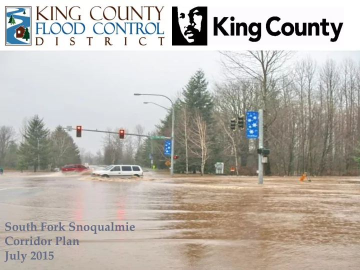
South Fork Snoqualmie Corridor Plan South Fork Snoqualmie Status Briefing Corridor Plan Director True July 2015 April 44, 2015 Levee overtopping Road flooding and seepage Neighborhood flooding Flooding near I-90: Potential for
Levee overtopping and seepage Channel migration: Circle River Ranch Flooding near I-90: Potential for interstate closure Neighborhood flooding Road flooding
Flood Impacts 100- yr 500- yr Flow (cfs) 15,650 19,120 Structures 144 778 AV ($million) 53.8 147.9 Roads (mi.) 5.4 14.8 Acres 368 778
500 year flood protection if feasible
Eliminate high and moderate geotechnical problems
Mitigate channel migration risk over 50 years
Improve instream aquatic habitat
Improve riparian habitat
Sustainable cost-effective solutions
Reduce long-term maintenance & repair costs by 30%
Provide equitable outcomes
Incorporate multiple objectives through involvement
MAINTAIN EXISTING MANAGEMENT PRACTICES
Maintain Existing Management Practices
Blue areas represent new areas of flooding
Hashed area represents areas that flood now Red area represent areas no longer flooded
100-year Flood
500-year Flood
Blue areas represent new areas of flooding
Hashed area represents areas that flood now Red area represent areas no longer flooded
500-year Flood
Blue areas represent new areas of flooding
Hashed area represents areas that flood now Red area represent areas no longer flooded
500-year Flood
Blue areas represent new areas of flooding
Hashed area represents areas that flood now Red area represent areas no longer flooded
Solve geotechnical problems Solve hydraulic problems Manage or accommodate sediment
Increases in floodplain connectivity Increase in velocity refuges for fish
Implementation costs Projected maintenance and repair costs
Multi-objective benefits Limit downstream impacts Gravel management Effects on recreation/ trails access
Structures Inundated (10's of structures) Critical Facilities Inundated Local /Arterial Roadway Inundated (in 1000's of feet) Interstate Inundated (in 100's of feet) Assessed Value at Risk (in mil $)
Cost to Implement (in mil $)
Maintain Existing Management Practices Corridor Wide Levee Setbacks Raise Levees In Place Hybrid Approach
Home Buyouts Undeveloped Property Buyout Easements Needed Home Elevations
Flood Control District Approval (4th quarter 2015) County Council adoption (1st quarter 2016?)
January 2009 – Water close to