SLIDE 9 Clean Water Act Regulatory Agencies Protecting Waters of the United States
Ephemeral Wash within project limits Santa Cruz River in project limits Wetland analysis test pit
The Clean Water Act (CWA) was passed by Congress in 1972. It establishes the framework for regulating discharges of pollutants into the Waters of the United States, as well as regulating quality standards for surface waters. Key Sections of the CWA include:
- Section 401 – Creates a water quality
certification tool for states and tribes.
- Section 402 – Authorizes Arizona
Pollutant Discharge Elimination System (AZPDES) permit requirements for stormwater discharges.
- Stormwater Pollution Prevention
Plan (SWPPP) will be prepared and implemented to control pollutants and sediment from leaving the site during construction.
- Section 404 - Establishes a program to
regulate the discharge of dredged and fill material into Waters of the United States, including wetlands. Water resources within the project area are regulated by the U.S. Army Corps of Engineers (USACE), Arizona Dept. of Environmental Quality (ADEQ), and Pima County Regional Flood Control District (PCRFCD).
Wetland along the Santa Cruz River in project limits
A PJD is a document that defines the aerial extent of USACE jurisdiction by identifying wetlands and Waters of the U.S. This document was approved for the project on May 5, 2104 A Section 404 Nationwide Permit No.14 (NWP 14) will be submitted. This permit allows construction activities required for linear transportation projects that impact less than 0.5 acres of wetlands or Waters of the U.S. The NWP 14 with a Pre- construction Notice (PCN), is required for projects impacting more than 0.1 but less than 0.5 acres of Waters of the U.S., or any impacts to wetlands. The PCN is submitted to the USACE District Engineer for review
Potential wetlands and Waters of the U.S. within project limits
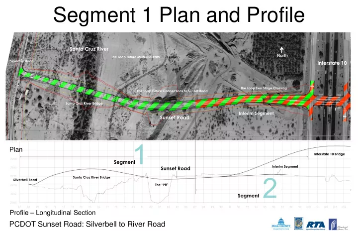
PCDOT Sunset Road: Silverbell to River Road
Water Resources