s
play

S Ministry of Foreign Affairs Republic of Cyprus Nicosia, - PDF document

5/31/2019 Recent developments in the continental shelf/EEZ of the Republic of Cyprus Ambassador Tasos Tzionis S Ministry of Foreign Affairs Republic of Cyprus Nicosia, 31.05.2019 European Union marine waters 1 5/31/2019 European Union


  1. 5/31/2019 Recent developments in the continental shelf/EEZ of the Republic of Cyprus Ambassador Tasos Tzionis S Ministry of Foreign Affairs Republic of Cyprus Nicosia, 31.05.2019 European Union marine waters 1

  2. 5/31/2019 European Union marine waters  What is the meaning of European Union marine waters?  Marine waters under the sovereignty and jurisdiction of Member States of the European Union  Continuity of marine space starting from the Baltic Sea, surrounding the EU Member-States and ending in the Eastern Mediterranean Sea.  Cyprus ’ maritime boundaries with its non-EU neighbouring States, namely Turkey, Syria, Lebanon, Israel and Egypt, are the southern- most and eastern-most maritime boundaries of the European Union. European Union marine waters 
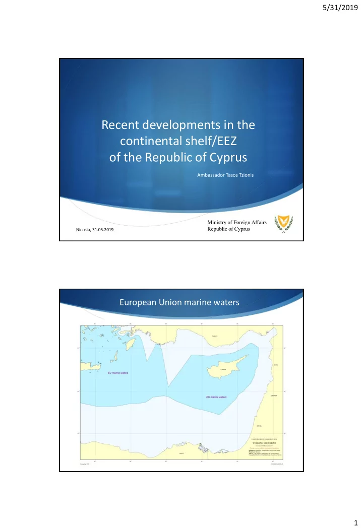
Source: Reporting under the Marine Strategy Framework Directive (MSFD) 2008/56/EC http://cdr.eionet.europa.eu/cy/eu/msfd8910/msfd4geo/envuzvkwq/ 2

  3. 5/31/2019 Cyprus’ maritime zones  12 nautical miles territorial sea  Every coastal state has ipso facto and ab initio exclusive sovereign rights over the natural resources of its continental shelf  Proclamation/establishment of a maritime zone is, by definition, a unilateral sovereign act of any coastal state  Cyprus has duly proclaimed an EEZ in 2004 and has submitted the relevant information to the Secretary-General of the UN, the depository of UNCLOS  Cyprus has also declared a 24 nm contiguous zone Cyprus’ continental shelf/EEZ limits 3

  4. 5/31/2019 EU/International Companies in Cyprus’ continental shelf/EEZ - today Discoveries in Cyprus’ continental shelf/EEZ 4

  5. 5/31/2019 Turkish drilling operations in Cyprus’ continental shelf/EEZ  The State-owned Turkish Petroleum company’s (TPAO) drilling vessel, ‘ Fatih ’, accompanied by Turkish navy frigates and submarines, was deployed on 4 th May well within the continental shelf/EEZ of the Republic of Cyprus  Drilling target: - 36.6 nm from the nearest coast of Cyprus - 30 nm from the median line between the coasts of the two States, towards the coast of Cyprus - as far as, at least 83 n.m. from the coast of Turkey  Navigational warning 0560/19 – Antalya Radio – announced drilling operations by ‘ Fatih ’ and supporting vessels, between 03 May – 03 September 2019 Turkey’s drilling target 5

  6. 5/31/2019 Turkish claims in Cyprus’ continental shelf/EEZ Drilling does not aim to benefit TCs  The drilling area lies within a maritime area claimed, with no plausible basis, by Turkey as part of its own continental shelf  By its own admission, Turkey’s claim to the continental shelf to the west of Cyprus does not aim to benefit the Turkish Cypriot community  It is a claim to continental shelf solely for the Republic of Turkey  This is contrary to the very interests of the Turkish Cypriots who, together with the Greek Cypriots, would be deprived of the fair share of the benefits over the resources of the western maritime area of Cyprus 6

  7. 5/31/2019 Turkish view of Cyprus’ EEZ/continental shelf  This is what would remain for Cyprus if the Turkish view were to be imposed or tolerated  Cyprus (Greek Cypriots and Turkish Cypriots alike) would practically lose 69% of its continental shelf/EEZ SAIPEM incident (02/2018)  February 2018  the Turkish Navy prevented ENI’s  Turkish navy’s actions constituted a drilling vessel ‘SAIPEM 12000 ’ from conducting threat of use of force, in violation exploratory drillings on behalf of the Republic of of Article 2(4) UN Charter Cyprus in Block 3 of Cyprus’ continental shelf/EEZ 7

  8. 5/31/2019 Turkey’s illegal seismic surveys - BARBAROS (October 2018 - today) N/W 1032/18: 18 OCT 18 - 01 FEB 19 N/W 0147/19: 26 JAN - 26 N/W 0549/19: MAY 19 01 MAY - 31 JUL 19  Turkish survey vessel ‘ Barbaros ’ has been performing illegal seismic surveys within the continental shelf/EEZ of the Republic of Cyprus since 2014 .  As of 10/2018, ‘ Barbaros ’ has been conducting illegal seismic surveys as shown in map. Cyprus – Turkey Maritime Delimitation  In accordance with international law (both UNCLOS and customary), the delimitation of the continental shelf or the EEZ between States with opposite or adjacent coasts shall be effected by agreement on the basis of international law in order to achieve an equitable result  Cyprus has repeatedly called upon Turkey to enter into negotiations for the delimitation of their maritime zones, in accordance with international law  This invitation to Turkey was, in fact, repeated in a letter addressed to the UN Secretary-General, on 12th December 2018  Turkey dismissed any efforts for a peaceful negotiation, and has resorted to actions that jeopardize and hamper the reaching of a final agreement, in violation of Articles 74(3) and 83(3) UNCLOS, which reflect customary principles such as good faith, self-restraint and peaceful settlement of disputes 8

  9. 5/31/2019 Recourse to dispute settlement mechanism  Maritime delimitation may of course be effected by recourse to an international dispute settlement mechanism (eg. conciliation, arbitration, ITLOS, ICJ)  Turkey:  not a party to UNCLOS  does not accept the compulsory jurisdiction of the International Court of Justice  Has chosen to keep itself outside the ambit of all such third- party dispute resolution procedures  Also, due to its own refusal to accept recourse to international adjudication, there is NO international dispute settlement mechanism that Turkey’s assertions can be put to the test Turkey’s rejection of the median line  In the absence of a delimitation agreement, only claims up to the median line are acceptable  Cyprus has declared that the outer limit of its continental shelf/EEZ is the median line with Turkey  Turkey’s claims, however, extend far over the median line. This demonstrates how Turkey exercises what it regards as its ‘rights’ in an abusive manner contrary to international law  There is no plausible basis for Turkey’s claim in the western maritime areas of Cyprus. Turkey’s position that a vast maritime area in the Eastern Mediterranean Sea falls within its continental shelf is inconsistent with international law 9

  10. 5/31/2019 Characterization of the area as “disputed” S As a matter of international law, Cyprus’ sovereign rights over its continental shelf and EEZ cannot be abrogated by an announcement by another State that it has a claim to an area of the EEZ or continental shelf of the Republic of Cyprus S In order for a genuine dispute even to arise it is at the very least necessary that the other State put forward a plausible legal claim to the area in question S Patently unreasonable conflicting claims CANNOT deprive a coastal State of its rights under international law or require the suspension of the exercise of those rights Maritime Delimitation Law  The international law rules applicable to maritime delimitation are clear, are firmly established, and are applied world-wide  International courts and tribunals have long been utilising the median/equidistant line as the starting point when applying the ‘three -stage method’ in delimitation cases (starting from the 2009 Black Sea case)  Based on a) the drawing of a provisional equidistance line, b) if necessary, its modification to take account of special/relevant circumstances c) checking the equitableness of the result  International jurisprudence has firmly established that a delimitation effected according to the median line/equidistance method is, prima facie , equitable (eg. 1993 Denmark v Norway case) 10

  11. 5/31/2019 Median line in the Eastern Mediterranean  There are no such special/relevant circumstances here and the provisional equidistance line in this case is clearly equitable  The fact that Turkey has a longer coastline than Cyprus does not entail that it must be allocated a broader maritime space than it gains from the application of the median line  Egypt possesses a longer coastline than Cyprus (comparable to the coast of Turkey)  Cyprus-Egypt EEZ Delimitation Agreement (2003), based on the median line  Lebanon and Israel have also agreed to a maritime boundary with Cyprus according to the median line  General acceptance by the international community, and the countries of the region, that the median line is a proper approach to the achievement of an equitable delimitation Islands and maritime delimitation  Article 121 UNCLOS – customary international law (2001 Qatar v Bahrain ; 2012 Nicaragua v Colombia ): an island has the same rights to all maritime zones as a land territory  There is no legal basis for the argument that all islands necessarily ‘distort’ equitable delimitation and should therefore be given diminished effect  The majority of delimitation cases cited by Turkey in which international courts and tribunals gave reduced effect to islands concerned small and/or isolated islands belonging to continental States, or to islands that lie on the ‘wrong side’ of a median line drawn between the main territories of the States concerned 11

Download Presentation
Download Policy: The content available on the website is offered to you 'AS IS' for your personal information and use only. It cannot be commercialized, licensed, or distributed on other websites without prior consent from the author. To download a presentation, simply click this link. If you encounter any difficulties during the download process, it's possible that the publisher has removed the file from their server.

Recommend


More recommend