
SLIDE 1
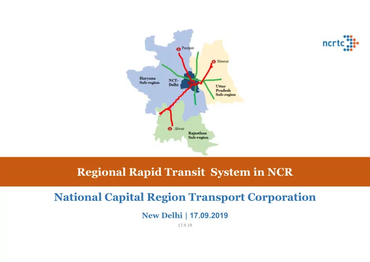
Regional Rapid Transit System in NCR National Capital Region Transport Corporation
New Delhi | 17.09.2019
17.9.19
Regional Rapid Transit System in NCR National Capital Region - - PowerPoint PPT Presentation
Regional Rapid Transit System in NCR National Capital Region Transport Corporation New Delhi | 17.09.2019 17.9.19 World is changing Some Facts 40 India will have 7 cities of 35 population more than 10 30 million by 2030 Delhi will
New Delhi | 17.09.2019
17.9.19
5 10 15 20 25 30 35 40 New York London Tokyo Beijing Delhi Mumbai Kolkata Mexico Sao Paulo 1960 1970 1980 1990 2000 2010 2020 2030
Source – World Urbanization Prospects 2018 – UN DESA
Some Facts
population more than 10 million by 2030
become world’s most populous city
be in Asia: India and China
population
17.9.19
Consequences of rapid urbanization in Delhi & NCR Unmanageable Urban Sprawl Lacking Regional Public Transport – low frequency – lack of integration - Multiple interchanges Pollution2: 40% increase in vehicular pollution - 2010 & 2018 Road vehicles contribute as high as 41% of the pollution Vehicles from NCR contribute 40%-50% Congestion Vanishing off-peak hours; 63% share of Private Transport Regional Travel on Delhi-Meerut Accidents In 2016 – highest # of deaths in Delhi – 1591 (highest among top 50 cities with million plus population)
1: World Bank data 2: Report No. 92, EPCA, Oct. 2018
Population trend of mega cities in World1
Inadequate regional mobility – constraining economic growth
10 15 20 25 30 35 40 2005 2014 2030 Population in Millions
Tokyo Delhi Shanghai Beijing New York
17.9.19
Better Connectivity triggers Urban Development
Night Imagery- NCR
17.9.19
infrastructure with multi- modal integration:
17.9.19
Network of Networks - Paris Metropolitan Region
Regional Express Rail
257 stations 587 kms
Metro
384 stops 216.5 kms
Tramway
148 stations 95 kms
Buses
12,500 stops 347 lines
Regional Rail serves as the main transport backbone of the region with buses and metros supplementing as feeders Regional Rail serves as the main transport backbone of the region with buses and metros supplementing as feeders
Sub-Urban Nodes Regional express rail Motorways
Dreu x To Lyon Vernon Gisors Creil Crépy-en- Valois Provins To Reims Montreau Nemours To Orleans Rambouillet
PARIS CBD PARIS CBD
Regional Express Rails connect sub-urban centers to Paris CBD Co existence of multiple modes performing different roles in the metropolitan region
Line A: 108 KM Line B: 80 KM Line C: 185 KM Line D: 190 KM Line E: 52 KM
17.9.19
Network of Networks - Seoul Metropolitan Region
GTX Network
22 stations 140 Kms
Seoul Urban Rail
293 stations 316 Kms
Seoul BRT 115 Kms GTX Network connecting sub-urban centers to Seoul CBD along with expressways for private vehicles and freight GTX Network connecting sub-urban centers to Seoul CBD along with expressways for private vehicles and freight
Sub-Urban Nodes GTX Rail Roadways
Paju Dongducheo n Namyangju Ozan Seongnan Incheon
329 stations Line B Line A Line C
17.9.19
Functional Plan on Transport for NCR-2032 - eight (8) Corridors of RRTS
having representation of GOI and NCR States –
Delhi-Ghaziabad-Meerut (Sanctioned by GoI –
07.03.2019) – in implementation phase
Delhi-Gurugram-Alwar Delhi-Panipat
to oversee the planning
17.9.19
Design speed of 180 kmph (Delhi to Meerut in 60-65 min) Train every ~5-10 min. & serving traffic nodes every 5-10 kms Universal Access – Dedicated Women Coach Reduced Land use for high throughput Commuter friendly information system Weather proof – rains, fog High capacity, comfortable journey, airline seating
RRTS – Rail based high speed, high capacity, comfortable and safe commuter service connecting regional nodes. It will help in reducing Road Congestion, Energy Consumption and Pollution
Interoperable Corridors & Multimodal Integration
RRTS trains will travel at 3 times the average speed of Metro
17.9.19
Parameters Delhi – Meerut Delhi – Panipat Delhi – Alwar Total Length (km) 82.15 103 164 Estimated travel time (min) 60 70 100
24 12 19 ~ 350 kms 600 coaches 6 Depot. ~ 2 mn daily ridership
17.9.19
Meerut to Education City in Haryana: 150-160 min Ghaziabad to Gurgaon (Cyber City): 160-170 min Meerut to IGI Airport: 230-240 min Ghaziabad to Manesar: 190-200 min
Travel time by Road Travel time by RRTS
Ghaziabad to Gurgaon (Cyber City): 35-40 min Meerut to IGI Airport: 70-75 min Ghaziabad to Manesar: 55-60 min Meerut to Education City in Haryana: 90-95 min
Meerut Alwar Delhi Panipat Meerut Ghaziabad
17.9.19
Area covered by Metro in 1 hr
Share of Public Transport Increase in share of public transport from 37% to 63%
Car 36% Two Wheeler Bus 5% Rail 32%
Modal Shift after RRTS
Car 22% Two Wheeler 15% Bus 2% Rail 15% RRTS 46%
17.9.19
All three corridors of phase I will converge at Sarai Kale Khan & will be interoperable providing seamless movement 1 2 Creating a Network of Networks Multimodal integration (MMI) with various modes of pubic transport
Modes MMI with RRTS Metro Rail Systems Delhi Metro :With 7 metro lines, at Ghaziabad, Anand Vihar, New Ashok Nagar, SKK, Jor Bagh, Aerocity, Indraprastha, Kashmere Gate, Munirka Meerut Metro: At Begumpul Gurgaon Rapid Metro: Udyog Vihar Bawal Metro: At Panchgaon, Kherki Daula Airport At Indira Gandhi International Airport, Delhi – Aerocity Metro Station Indian Railways Hazrat Nizamuddin & Anand Vihar ISBTs Sarai Kale Khan, Kashmere Gate, Anand Vihar, Panchgaon Other Bus Terminal/ Depot Kaushambi Bus Depot, Sahibabad Bus Adda, Ghaziabad New Bus Adda, Bhaisali Bus Adda (Meerut), Bawal, etc.
17.9.19
17.9.19
dedicated rail connectivity
every 5-10 kms – 24 stations
modes of transport
37% to 63% – 0.1 Mn vehicles off the road
Not merely connecting two cities but serving 82 km of urban strip
Corridor Length: 82.15 km
Elevated Underground
17.9.19
Govt. of India accorded its sanction – March 2019 Approval of Govt. of Uttar Pradesh – March 2019 Approval of Govt. of NCT of Delhi – February 2019 Foundation Stone Laid by Hon’ble Prime Minister - March 2019
Construction of priority section started in the month of June 2019
17.9.19
17.9.19
17.9.19
17.9.19
Parameters SKK – SNB Total Length (km) 106.5 Elevated (km) 70.56 In Delhi 0.22 In Haryana 68.41 In Rajasthan 1.93 Underground (km) 35.94 In Delhi 21.86 In Haryana 14.08 In Rajasthan 0.0 Estimated travel time ~ 70 min
16 In Delhi (U/G: 3) 4 In Haryana (U/G: 2) 11 In Rajasthan 1
17.9.19
Status of Delhi-Gurugram-SNB RRTS Corridor
progress. Geotechnical investigation works – in progress
17.9.19
17.9.19
Parameters Value Total Length (km 104 In Delhi Elevated (km) 30.17 Underground (km) 6.83 In Haryana Elevated (km) 62 Underground (km) 5 Estimated travel time (min) ~65 min
16
6
10
17.9.19
NCR Transport Corporation, 7/6, Siri Fort Institutional area, August Kranti Marg, New Delhi 110049 Website ncrtc.in
17.9.19