
SLIDE 1
Public Hearing Presentation
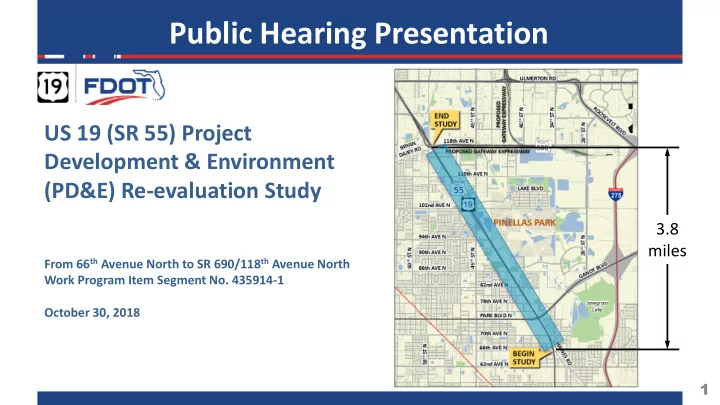
3.8 miles
From 66th Avenue North to SR 690/118th Avenue North Work Program Item Segment No. 435914-1 October 30, 2018
US 19 (SR 55) Project Development & Environment (PD&E) Re-evaluation Study
1
Public Hearing Presentation US 19 (SR 55) Project Development & - - PowerPoint PPT Presentation
Public Hearing Presentation US 19 (SR 55) Project Development & Environment (PD&E) Re-evaluation Study 3.8 miles From 66 th Avenue North to SR 690/118 th Avenue North Work Program Item Segment No. 435914-1 October 30, 2018 1 The
From 66th Avenue North to SR 690/118th Avenue North Work Program Item Segment No. 435914-1 October 30, 2018
1
2
3
4
5
6
7
8
9
Ave N to 80th Ave N
19
8-Lanes Gandy Blvd from Interstate 275
40th St N to 43rd St N on Park Blvd.
Accommodations Throughout
The Shoppes At Park Place Wal-Mart
10
approach
Westbound Approach
The Shoppes At Park Place
11
12
13
14
15
16
Warrant Analysis
Turns
Accommodations
Crossing from PSTA Bus Stop
PSTA Stop Proposed Raised Median Bi-directional median to be removed
17
A. Social & Economic
1. Social 2. Economic 3. Land Use Changes 4. Mobility 5. Aesthetic Effects 6. Relocation Potential 7. Farmland
1. Section 4(f) 2. Historic Sites/Districts 3. Archaeological Sites 4. Recreational Areas
C.
Natural
1. Wetlands and Other Surface Waters 2. Aquatic Preserves and Outstanding FL Waters 3. Water Quality and Water Quantity 4. Wild and Scenic Rivers 5. Floodplains 6. Coastal Zone Consist. 7. Coastal Barrier Resources 8. Protected Species and Habitat 9. Essential Fish Habitat
1. Highway Traffic Noise 2. Air Quality 3. Contamination 4. Utilities and Railroads 5. Construction 6. Bicycles and Pedestrians 7. Navigation
18
contamination
should be conducted
Archaeological
Historical
No identified cultural resources (archaeological
eligible, or appear potentially eligible for listing in the National Register of Historic Places. 19
Channel 3
impact
conveyance to floodplains and floodways
considered not significant
noise
barrier at the Pine Ridge Court Mobile Home Park, during final design 20
4(f) resources by the proposed project.
protected species
affect
tricolored heron, and roseate spoonbill
drainage canals totaling 0.34 acres
to Section 373.4137, F.S. 21
22
23
24
FDOT Adopted with Amended Five Year Work Program for FY 2017 – 2022
25
26
27