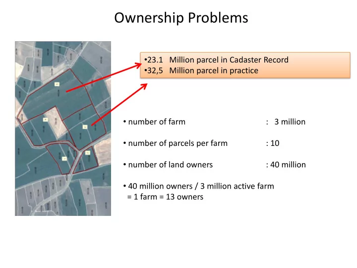
Ownership Problems 23.1 Million parcel in Cadaster Record 32,5 - - PowerPoint PPT Presentation

ownership problems
SMART_READER_LITE
LIVE PREVIEW

Ownership Problems 23.1 Million parcel in Cadaster Record 32,5 - - PowerPoint PPT Presentation

Ownership Problems 23.1 Million parcel in Cadaster Record 32,5 Million parcel in practice number of farm : 3 million number of parcels per farm : 10 number of land owners : 40 million 40 million owners / 3 million


slide-1
SLIDE 1

Ownership Problems

  • 23.1 Million parcel in Cadaster Record
  • 32,5 Million parcel in practice
  • number of farm

: 3 million

  • number of parcels per farm

: 10

  • number of land owners

: 40 million

  • 40 million owners / 3 million active farm

= 1 farm = 13 owners

slide-2
SLIDE 2

WHAT IS THE LAND CONSOLIDATION?

THUS, IRRIGATION RATE HAS EXCEEDED OVER 80’S %

Ex Ownership Irrigation canals The shape after the consolidation Former and new plots Integration of 7 plots

slide-3
SLIDE 3

Sensor Sensor Sensor Index Calculator Index Calculator Event Computer Event Computer

initial state initial state

Sensor Fusion Scheme

35x1200senors 12Mx200+ Layers xST

slide-4
SLIDE 4
slide-5
SLIDE 5
slide-6
SLIDE 6

Real Time Mapping for Hourly Precipitation

slide-7
SLIDE 7

Real Time Mapping for Leaf Wetness Index

slide-8
SLIDE 8

Drought & Risk Management in Turkey

Data Fusion System (spatio-temporal Data) Remote Sensing System (Spatial Data) Administrative Data Agro-meteo- pheno Monitoring Network Drought Monitoring Crop Monitoring Land and Resource Monitoring Drought and Risk Management Crop Pattern Management (subsidy, …) Decision Support Systems Policy Management (9-Level plan)

slide-9
SLIDE 9
slide-10
SLIDE 10

Intranet

Turksat GPS yield (kg/da, humid., x,y,t) Yield Verification via harvesting monitors

slide-11
SLIDE 11
slide-12
SLIDE 12

e-form and Image assistants Harvesting machines YE data acquistion Yield Monitoring Trajectory Planning Sampling & Data Acquisiton Management Monitoring devices’ Phenological stage detection sys.

Terrestrial monitoring network

Efficiency indices calculator Data Fusion System Risk and loss Estimation system Yield Efficiency Estimation Yield Efficiency Computations Continous Yield Monitoring Prediction and Reporting System Risk indices calculator Yield efficiency monitoring network TARGEL staff mobile Observation network Remote Sensing satellite constellation V(x,y,m,t)

T(b, x, y, t, s) G(b, x, y, t, s) Ri(.)

Agricultural field Cadastral and regs. DB

(1) (2) (3) (12) (11) (4) (8) (6) (5) (7) (14) (9) (10) (13)

i=1..8