nasa helps finding damaged buildings using satellite
play

NASA Helps Finding Damaged Buildings using Satellite Radar Data - PowerPoint PPT Presentation

NASA Helps Finding Damaged Buildings using Satellite Radar Data NASAs JPL Produced Damage Proxy Map (DPM) derived from Synthetic Aperture Radar (SAR) data acquired from Italian Space Agencys (ASIs) COSMO- SkyMed satellites.


  1. NASA Helps Finding Damaged Buildings using Satellite Radar Data  
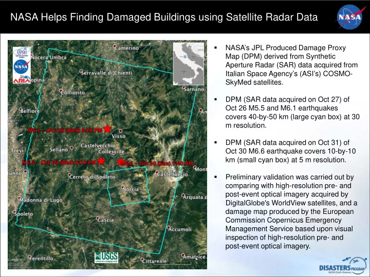
NASA’s JPL Produced Damage Proxy Map (DPM) derived from Synthetic Aperture Radar (SAR) data acquired from Italian Space Agency’s (ASI’s) COSMO- SkyMed satellites.  DPM (SAR data acquired on Oct 27) of Oct 26 M5.5 and M6.1 earthquakes covers 40-by-50 km (large cyan box) at 30 m resolution.  DPM (SAR data acquired on Oct 31) of Oct 30 M6.6 earthquake covers 10-by-10 km (small cyan box) at 5 m resolution.  Preliminary validation was carried out by comparing with high-resolution pre- and post-event optical imagery acquired by DigitalGlobe's WorldView satellites, and a damage map produced by the European Commission Copernicus Emergency Management Service based upon visual inspection of high-resolution pre- and post-event optical imagery.

  2. Satellite Radar Data Reveals Damage in Norcia, Italy Red pixels in ARIA DPM (pixel ARIA DPM BEFORE (WorldView) size about 5 m, overlaid on Google Earth) represent areas of potential damage due to the M6.6 Oct 30, 2016 Central Italy Earthquakes, as well as ground surface change during the time period Oct 30, 2016 - - Oct 31, 2016. The color variation from yellow to red indicates increasingly more significant ground surface change. Copernicus AFTER (WorldView) Norcia Basilica Photo Courtesy: Matteo Guidelli / AP

  3. Small Scale Damage can be Detected by Radar ARIA DPM BEFORE (WorldView) ARIA DPM was derived from COSMO-SkyMed radar data acquired on Oct 30, 2016 and Oct 31, 2016. Pixel size is about 5 m. The resolution of the original SAR data is about 1 m. High-resolution SAR data are sensitive to small scale damage. Damage map produced by the European Commission Copernicus Emergency Management Service based upon Copernicus AFTER (WorldView) visual inspection of high-resolution pre- (Orthophoto, 50 cm resolution, acquired in 2014) and post-event (Pleiades-1, 50 cm resolution, acquired on Oct 31, 2016) optical imagery. Different time span can introduce false positives and false negatives.

Download Presentation
Download Policy: The content available on the website is offered to you 'AS IS' for your personal information and use only. It cannot be commercialized, licensed, or distributed on other websites without prior consent from the author. To download a presentation, simply click this link. If you encounter any difficulties during the download process, it's possible that the publisher has removed the file from their server.

Recommend


More recommend