
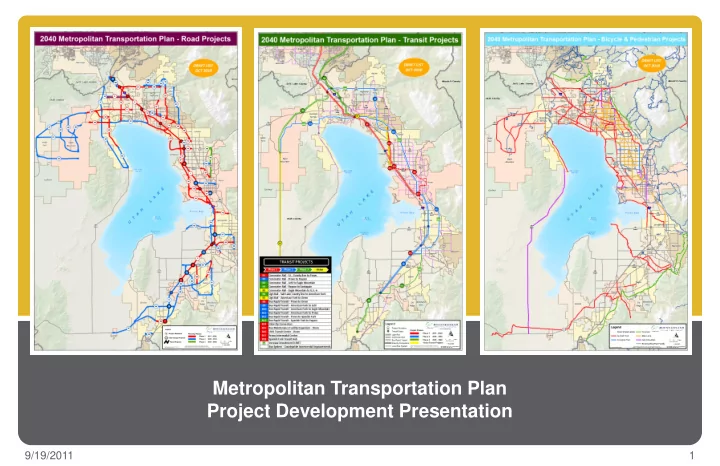
SLIDE 1
Metropolitan Transportation Plan Project Development Presentation
1 9/19/2011
Metropolitan Transportation Plan Project Development Presentation - - PowerPoint PPT Presentation
Metropolitan Transportation Plan Project Development Presentation 9/19/2011 1 Draft Listing of Highway Projects Does Not Include Any New Freeways Have Reviewed with City Staff So Far Minor Changes Have Been Suggested Red = Needed
1 9/19/2011
3 9/19/2011
4 9/19/2011
5 9/19/2011
6 9/19/2011
7 9/19/2011
Each have about 1 million population and have multiple freeways and expressways
8 9/19/2011
30 years, Utah Co. lacks ideal freeway spacing
choke points in Lehi, Santaquin, Lindon, and Springville
today, SL Co. is close to ideal freeway spacing
needs better east/west connectivity
ITE Ideal Highway Spacing
9 9/19/2011
134k 102k 52k
Metropolitan Transportation Plan
Lehi CP Cedar Pass CP
145k 127k 156k 37k 32k 28k
Lindon CP
V2 V1
−Pony Exp PKWY Fails −S Pass RD not used −N Pass RD not used −Pioneer Crossing Fails −No relief to Choke Point −I-15 Fails −No relief to Choke Point −Pony Exp PKWY Fails −HWY 73 Fails, has FWY traffic level, 67k −N Pass RD not used −Pioneer Crossing Fails −No relief to Choke Point −I-15 Fails −No relief to Choke Point −Pony Exp PKWY Fails −South Pass RD is Minor Arterial −Pioneer Crossing is Congested −No relief to Choke Point −I-15 Fails −No relief to Choke Point
Cedar Pass Choke Point Conditions Lehi Choke Point Conditions Lindon Choke Point Conditions
2040 Traffic 2007 I-15 Traffic 126k
The Question is Always Asked… “Why Not Build A Bypass to I-15 on the West Side of the Lake?”
10 9/19/2011
Metropolitan Transportation Plan
145k 127k 156k 134k 102k 52k 37k 32k 28k
Cedar Pass Choke Point Conditions Lehi Choke Point Conditions Lindon Choke Point Conditions
V5 V4
−Pony Exp PKWY Congested −S Pass RD M.ART −N Pass RD not used −All Corridors Good −Relieves Choke Point −Reduces I-15 by 20k −Blue Corridor adds 20k to Vineyard Connector −Pony Exp PKWY Fails −HWY 73 Fails, has FWY traffic level, 67k −Pioneer Crossing Fails −Congestion in central and southern Lehi −Reduces I-15 by 40k −Blue Corridor adds 20k to Vineyard Connector −Pony Exp PKWY Fails −South Pass RD is Minor Arterial −All Corridors Good −Relieves Choke Point −Reduces I-15 by 20k −Blue Corridor adds 20k to Vineyard Connector
Lehi CP Cedar Pass CP Lindon CP
11 9/19/2011
2040 Traffic 2007 I-15 Traffic 126k
N Cedar Pass to Santaquin FWY | 6 Lanes Point of Mtn FWY | 8 Lanes Mtn View FWY to HWY 73 | 8 Lanes Mtn View FWY to Foothill | 6 Lanes Lake Crossing FWY | 6 Lanes I-15 FWY | 12 Lanes Payson to Provo FWY | 6 Lanes HWY 73 | 6 Lanes Pony Express PKWY/Lehi 1900 S | 4 Lanes Redwood RD | 4 Lanes
FREEWAYS ARTERIALS
(Expressways)
2040 Traffic 2007 I-15 Traffic
126k
15
Lehi 2100 N
12 9/19/2011
Pony Exp PKWY
EXPRESSWAYS
Lehi 2100 N EXPWY | 6 Lanes Hidden Valley EXPWY | 6 Lanes Pioneer Crossing EXPWY | 6 Lanes Foothill EXPWY | 4 Lanes Vineyard Connector EXPWY | 6 Lanes
N Cedar Pass to Santaquin FWY | 6 Lanes Lehi 2100 N FWY | 10 Lanes Mtn View FWY to HWY 73 | 8 Lanes Mtn View FWY to Lake Crossing | 6 Lanes Lake Crossing FWY | 6 Lanes Payson to Provo FWY | 6 Lanes Lindon | 12 Lanes
Lehi | 12 Lanes
Point of the Mtn | 12 Lanes Orem | 12 Lanes Provo | 10 Lanes HWY 73 | 6 Lanes Pony Express PKWY | 4 Lanes Hidden Valley ART | 6 Lanes Pioneer Crossing | 6 Lanes Lehi 1900 South | 4 Lanes Vineyard Connector | 6 Lanes Redwood RD | 4 Lanes
15
FREEWAYS ARTERIALS
Congestion Starts at… FREEWAYS 6 Lane 105+ 8 Lane 140+ 10 Lane 175+ 12 Lane 210+ ARTERIALS 4 Lane 40k+ 6 Lane 55k+
(Freeway Grid Network)
145k 127k 134k
2040 Traffic 2007 I-15 Traffic
126k
FWY Arterial
15
Pony Exp PKWY
156k 84k 36k 54k 28k 58k 199k 258k 42k 79k 20k 167k 66k 75k 30k 19k 237k 267k 173k 246k 104k
15 15 15 15
13 9/19/2011
Extreme Congestion Congestion Constrained Flow Free Flow
Lehi CP
Cedar Pass CP
Lindon CP
Pioneer Crossing Lehi 2100 N
Metropolitan Transportation Plan
14 9/19/2011
Orange = I-15 FWY Green = West Side FWY Red = Mountain View/Lake Crossing FWY Blue = Payson to Provo FWY